
Recent from talks
Yukon River Basin
Knowledge base stats:
Talk channels stats:
Members stats:
Yukon River Basin
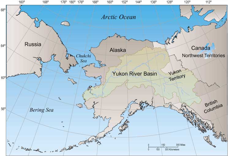
The Yukon River Basin is located between the Yukon Territory in Canada and Alaska in the United States, with a small portion in British Columbia, Canada. This basin is made up of 13 other individual basins that drain into the Yukon River and other adjoining rivers and tributaries. The Yukon River Basin is 330,000 square miles (850,000 km2) in area and 1,980 miles (3,190 km) in length. Many different geological features make up the basin, including several types of terrain, shrubland, and rivers.
In the mid to late 1800s, European and American explorers discovered its natural resources and began settling in the region. The Yukon River Basin remains a relatively intact ecosystem, known for its density of salmon, which are used as both food for the villagers and a growing industry for the community.
Some of the oldest known humans who inhabited North America are thought to have lived around the western part of the Yukon Basin. They migrated across the land bridge, Beringia, living without influence from other cultures for hundreds of years.
The earliest exploration and European settlement in the Yukon River Basin was by Robert Campbell in 1840. Early explorers like Campbell came not for gold but for furs. In the 1870s, explorers like Leroy McQuesten, Arthur Harper, and Alfred Mayo discovered how plentiful the Yukon river and Yukon River basin was with minerals. Their mining ventures grew and spread until they reached the Stewart River, where they found gold, starting the Klondike Gold Rush.
The Yukon River Basin is approximately 330,000 square miles (850,000 km2) in area and 1,980 miles (3,190 km) in length. This makes the Yukon River Basin the fourth largest basin in North America. It is located between the Rocky Mountains in the north and the Pacific Mountain system to the south. The Basin spans across Canada in the Yukon Territory and the US state of Alaska. The Yukon Flats basin is south of the Yukon River Basin and it drains deposits and reworked materials into the Flats. It is within the Arctic Complex of the Arctic-Atlantic Bioregion, therefore has freshwater.
The Yukon River Basin is made up of 13 other individual basins and stretches across two countries: the United States of America and Canada. The topography of the Yukon Basin is diverse with different elevations. While there are 13 individual basins within the Basin, there are also 5 physio-graphic regions. They include Alaska Range (6,000–9,000 feet or 1,800–2,700 metres), Central and Eastern Brooks Range (7,000–8,000 feet or 2,100–2,400 metres), Indian River Uplands (1,500–2,000 feet or 460–610 metres), Innoko Lowlands (flat flood plains), and Kolkrine-Hodzana Highlands (2,000–4,000 feet or 610–1,220 metres).
Half of the Yukon River Basin lies in Canada, with the other half occupying space in Alaska. The Yukon River Basin is made up of many different geological terrains, with a variety of different rocks that make up the basin itself. These include various types of sedimentary, igneous, and metamorphic rocks There are several different land types that make up the entirety of the Yukon River Basin. These include the needleleaf forest, tall and low shrublands, broadleaf forest, lichens, barren, wet herbaceous, dwarf shrublands, dry herbaceous, ice/snow, and rivers, streams, and lakes. There are also many different types of soils that make up the Yukon River Basin. These soils include Entisols, Gelisols, Inceptisols, Inceptisols/Gelisols, Mollisols, Spodosols, and Rough Mountainous Land.
Permafrost dominates the Yukon River Basin. Because of the level of permafrost in the basin, the basin itself is far more prone to flash floods. The melting of permafrost is believed to be one of the reasons that the Yukon River Basin's flow has increased over the years, causing erosion of the basin.
Hub AI
Yukon River Basin AI simulator
(@Yukon River Basin_simulator)
Yukon River Basin
The Yukon River Basin is located between the Yukon Territory in Canada and Alaska in the United States, with a small portion in British Columbia, Canada. This basin is made up of 13 other individual basins that drain into the Yukon River and other adjoining rivers and tributaries. The Yukon River Basin is 330,000 square miles (850,000 km2) in area and 1,980 miles (3,190 km) in length. Many different geological features make up the basin, including several types of terrain, shrubland, and rivers.
In the mid to late 1800s, European and American explorers discovered its natural resources and began settling in the region. The Yukon River Basin remains a relatively intact ecosystem, known for its density of salmon, which are used as both food for the villagers and a growing industry for the community.
Some of the oldest known humans who inhabited North America are thought to have lived around the western part of the Yukon Basin. They migrated across the land bridge, Beringia, living without influence from other cultures for hundreds of years.
The earliest exploration and European settlement in the Yukon River Basin was by Robert Campbell in 1840. Early explorers like Campbell came not for gold but for furs. In the 1870s, explorers like Leroy McQuesten, Arthur Harper, and Alfred Mayo discovered how plentiful the Yukon river and Yukon River basin was with minerals. Their mining ventures grew and spread until they reached the Stewart River, where they found gold, starting the Klondike Gold Rush.
The Yukon River Basin is approximately 330,000 square miles (850,000 km2) in area and 1,980 miles (3,190 km) in length. This makes the Yukon River Basin the fourth largest basin in North America. It is located between the Rocky Mountains in the north and the Pacific Mountain system to the south. The Basin spans across Canada in the Yukon Territory and the US state of Alaska. The Yukon Flats basin is south of the Yukon River Basin and it drains deposits and reworked materials into the Flats. It is within the Arctic Complex of the Arctic-Atlantic Bioregion, therefore has freshwater.
The Yukon River Basin is made up of 13 other individual basins and stretches across two countries: the United States of America and Canada. The topography of the Yukon Basin is diverse with different elevations. While there are 13 individual basins within the Basin, there are also 5 physio-graphic regions. They include Alaska Range (6,000–9,000 feet or 1,800–2,700 metres), Central and Eastern Brooks Range (7,000–8,000 feet or 2,100–2,400 metres), Indian River Uplands (1,500–2,000 feet or 460–610 metres), Innoko Lowlands (flat flood plains), and Kolkrine-Hodzana Highlands (2,000–4,000 feet or 610–1,220 metres).
Half of the Yukon River Basin lies in Canada, with the other half occupying space in Alaska. The Yukon River Basin is made up of many different geological terrains, with a variety of different rocks that make up the basin itself. These include various types of sedimentary, igneous, and metamorphic rocks There are several different land types that make up the entirety of the Yukon River Basin. These include the needleleaf forest, tall and low shrublands, broadleaf forest, lichens, barren, wet herbaceous, dwarf shrublands, dry herbaceous, ice/snow, and rivers, streams, and lakes. There are also many different types of soils that make up the Yukon River Basin. These soils include Entisols, Gelisols, Inceptisols, Inceptisols/Gelisols, Mollisols, Spodosols, and Rough Mountainous Land.
Permafrost dominates the Yukon River Basin. Because of the level of permafrost in the basin, the basin itself is far more prone to flash floods. The melting of permafrost is believed to be one of the reasons that the Yukon River Basin's flow has increased over the years, causing erosion of the basin.
Recent media