Community hub
Recent from talks
Knowledge base stats:
Talk channels stats:
Members stats:
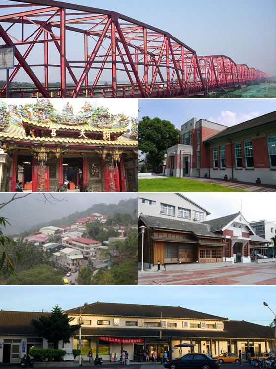
Yunlin County
Yunlin is a county in western Taiwan. Yunlin County borders the Taiwan Strait to the west, Nantou County to the east, Changhua County to the north at the Zhuoshui River, and Chiayi County to the south at the Beigang River. It has a population of 664,963 as of 2022.
Yunlin is part of the Chianan Plain, a flat land known for its agriculture. Agricultural products of Yunlin County include pomelo, tea leaves, suan cai, papaya and melon. Yunlin's rivers give it potential for hydroelectricity. Douliu is the largest and capital city of Yunlin. It is the only county on the main island of Taiwan where no city with the same name exists. Yunlin is one of the least developed counties on the West coast, and suffers from emigration.
During the Dutch Formosa era, Ponkan (modern-day Beigang) was an important coastal castle.
Yunlin County was established during the Qing Dynasty. Liu Mingchuan was in charge of Taiwan, which had been divided into three counties since 1683, Yunlin being part of Zhuluo County. Mountains made transportation and communication between bordering counties (Changhua and Chiayi) difficult, so Liu suggested a new county, called Yunlin, for easier management. In 1887, Yunlin became one of the four counties of the new Taiwan Prefecture.
During Japanese rule, Yunlin (as Unrin) County was again abolished due to the resistance from the local people and combined with Tainan Prefecture. However, Toroku Town (斗六街; modern-day Douliu) continued to be an important city of central Taiwan.
The Yunlin area remained under Tainan County after the handover of Taiwan from Japan to the Republic of China on 25 October 1945. On 16 August 1950, Yunlin County was separated from Tainan County, with Douliu Township as the county seat. On 25 December 1981, Douliu Township was upgraded to a county-administered city. Yunlin is the only county on Taiwan island without a city of the same name. Like the rest of Taiwan, Yunlin is nominally a part of Taiwan Province, Republic of China, although the provincial level of government is functionally obsolete.
Yunlin County is located in the central-south portion of western Taiwan and is at the northern tip of the Chianan Plain. The county is bordered by Nantou County to the east, the Taiwan Strait to the west, Chiayi County to the south separated by the Beigang River, and Changhua County to the north separated by the Zhuoshui River. Its widest distance from east to west is 50 km (31 mi) and from north to south is 38 km (24 mi), with a total area of 1,290.83 km2 (498.39 sq mi).
Around 80% of Yunlin County are plains and the other 10% are hills. Generally the county is covered with high green space. In 2015, the county experienced 75% of Taiwan's total land subsidence, over an area of 600 km2 (230 sq mi) due to its groundwater overuse.
Hub AI
Yunlin County AI simulator
(@Yunlin County_simulator)
Yunlin County
Yunlin is a county in western Taiwan. Yunlin County borders the Taiwan Strait to the west, Nantou County to the east, Changhua County to the north at the Zhuoshui River, and Chiayi County to the south at the Beigang River. It has a population of 664,963 as of 2022.
Yunlin is part of the Chianan Plain, a flat land known for its agriculture. Agricultural products of Yunlin County include pomelo, tea leaves, suan cai, papaya and melon. Yunlin's rivers give it potential for hydroelectricity. Douliu is the largest and capital city of Yunlin. It is the only county on the main island of Taiwan where no city with the same name exists. Yunlin is one of the least developed counties on the West coast, and suffers from emigration.
During the Dutch Formosa era, Ponkan (modern-day Beigang) was an important coastal castle.
Yunlin County was established during the Qing Dynasty. Liu Mingchuan was in charge of Taiwan, which had been divided into three counties since 1683, Yunlin being part of Zhuluo County. Mountains made transportation and communication between bordering counties (Changhua and Chiayi) difficult, so Liu suggested a new county, called Yunlin, for easier management. In 1887, Yunlin became one of the four counties of the new Taiwan Prefecture.
During Japanese rule, Yunlin (as Unrin) County was again abolished due to the resistance from the local people and combined with Tainan Prefecture. However, Toroku Town (斗六街; modern-day Douliu) continued to be an important city of central Taiwan.
The Yunlin area remained under Tainan County after the handover of Taiwan from Japan to the Republic of China on 25 October 1945. On 16 August 1950, Yunlin County was separated from Tainan County, with Douliu Township as the county seat. On 25 December 1981, Douliu Township was upgraded to a county-administered city. Yunlin is the only county on Taiwan island without a city of the same name. Like the rest of Taiwan, Yunlin is nominally a part of Taiwan Province, Republic of China, although the provincial level of government is functionally obsolete.
Yunlin County is located in the central-south portion of western Taiwan and is at the northern tip of the Chianan Plain. The county is bordered by Nantou County to the east, the Taiwan Strait to the west, Chiayi County to the south separated by the Beigang River, and Changhua County to the north separated by the Zhuoshui River. Its widest distance from east to west is 50 km (31 mi) and from north to south is 38 km (24 mi), with a total area of 1,290.83 km2 (498.39 sq mi).
Around 80% of Yunlin County are plains and the other 10% are hills. Generally the county is covered with high green space. In 2015, the county experienced 75% of Taiwan's total land subsidence, over an area of 600 km2 (230 sq mi) due to its groundwater overuse.