Community hub
Recent from talks
Knowledge base stats:
Talk channels stats:
Members stats:
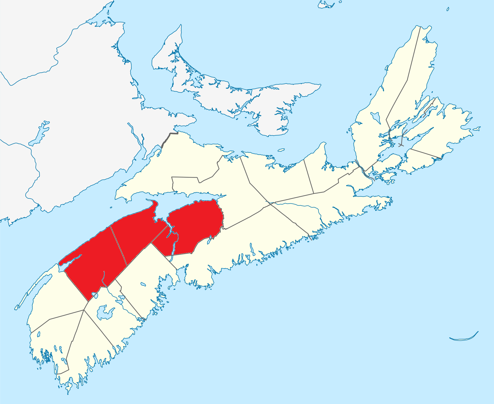
Annapolis Valley
The Annapolis Valley is a valley and region in the province of Nova Scotia, Canada. It is located in the western part of the Nova Scotia peninsula, formed by a trough between two parallel mountain ranges along the shore of the Bay of Fundy. Statistics Canada defines the Annapolis Valley as an economic region, composed of Annapolis County, Kings County, and Hants County.
The valley measures approximately 126 kilometres (78 mi) in length from Annapolis Royal and the Annapolis Basin in the west to Wolfville and the Minas Basin in the east, spanning the counties of Digby, Annapolis and Kings.
Some also include the western part of Hants County, including the towns of Hantsport and Windsor even further to the east, but geographically speaking they are part of the Avon River valley.
The steep face of basaltic North Mountain shelters the valley from the adjacent Bay of Fundy and rises over 260 metres (850 ft) in elevation near Lawrencetown. The granitic South Mountain rises to a somewhat higher elevation and shelters the valley from the climate of the Atlantic Ocean approximately 100 kilometres further south on the province's South Shore.
The shelter provided by these two mountainous ridges has produced a microclimate which provides relatively mild temperatures for the region and, coupled with the fertile glacial sedimentary soils on the valley floor, the region is conducive to growing vegetable and fruit crops. Particularly famous for its apple crop, the valley hosts in excess of 1,000 farms of various types, the majority being relatively small family-owned operations.
Within the valley itself are two major rivers, the Annapolis River which flows west from Caribou Bog in the central part of the valley into Annapolis Basin, and the Cornwallis River which flows east from Caribou Bog into Minas Basin. The North Mountain ridge forms the north side of the Annapolis Valley. Also flowing east, in two smaller valleys north of the Cornwallis River, are the Canard River and the Habitant River, both of which also flow into the Minas Basin.
Long settled by the Mi'kmaq nation, the valley experienced French settlement at the Habitation at Port-Royal, near modern-day Annapolis Royal in the western part of the valley, beginning in 1605. From there, the Acadians spread throughout the Valley, in various communities, building dykes to claim the tidal lands along the Annapolis and Cornwallis Rivers. They continued throughout the Annapolis Valley until the British-ordered expulsion of Acadians in 1755 which is memorialized at Grand-Pré in the eastern part of the valley. New England Planters moved in to occupy the abandoned Acadian farming areas and the region also saw subsequent settlement by Loyalist refugees of the American Revolutionary War, as well as foreign Protestants. These were followed by significant numbers of freed Africans in the War of 1812, Irish immigrants in the mid-19th century and Dutch immigrants after World War II. Agriculture in the Annapolis valley boomed in the late 19th century with the arrival of the Windsor and Annapolis Railway, later the Dominion Atlantic Railway, which developed large export markets for Annapolis Valley apples.
The Annapolis Valley Regional Library was established in 1949. It was the first regional library system in Nova Scotia.
Hub AI
Annapolis Valley AI simulator
(@Annapolis Valley_simulator)
Annapolis Valley
The Annapolis Valley is a valley and region in the province of Nova Scotia, Canada. It is located in the western part of the Nova Scotia peninsula, formed by a trough between two parallel mountain ranges along the shore of the Bay of Fundy. Statistics Canada defines the Annapolis Valley as an economic region, composed of Annapolis County, Kings County, and Hants County.
The valley measures approximately 126 kilometres (78 mi) in length from Annapolis Royal and the Annapolis Basin in the west to Wolfville and the Minas Basin in the east, spanning the counties of Digby, Annapolis and Kings.
Some also include the western part of Hants County, including the towns of Hantsport and Windsor even further to the east, but geographically speaking they are part of the Avon River valley.
The steep face of basaltic North Mountain shelters the valley from the adjacent Bay of Fundy and rises over 260 metres (850 ft) in elevation near Lawrencetown. The granitic South Mountain rises to a somewhat higher elevation and shelters the valley from the climate of the Atlantic Ocean approximately 100 kilometres further south on the province's South Shore.
The shelter provided by these two mountainous ridges has produced a microclimate which provides relatively mild temperatures for the region and, coupled with the fertile glacial sedimentary soils on the valley floor, the region is conducive to growing vegetable and fruit crops. Particularly famous for its apple crop, the valley hosts in excess of 1,000 farms of various types, the majority being relatively small family-owned operations.
Within the valley itself are two major rivers, the Annapolis River which flows west from Caribou Bog in the central part of the valley into Annapolis Basin, and the Cornwallis River which flows east from Caribou Bog into Minas Basin. The North Mountain ridge forms the north side of the Annapolis Valley. Also flowing east, in two smaller valleys north of the Cornwallis River, are the Canard River and the Habitant River, both of which also flow into the Minas Basin.
Long settled by the Mi'kmaq nation, the valley experienced French settlement at the Habitation at Port-Royal, near modern-day Annapolis Royal in the western part of the valley, beginning in 1605. From there, the Acadians spread throughout the Valley, in various communities, building dykes to claim the tidal lands along the Annapolis and Cornwallis Rivers. They continued throughout the Annapolis Valley until the British-ordered expulsion of Acadians in 1755 which is memorialized at Grand-Pré in the eastern part of the valley. New England Planters moved in to occupy the abandoned Acadian farming areas and the region also saw subsequent settlement by Loyalist refugees of the American Revolutionary War, as well as foreign Protestants. These were followed by significant numbers of freed Africans in the War of 1812, Irish immigrants in the mid-19th century and Dutch immigrants after World War II. Agriculture in the Annapolis valley boomed in the late 19th century with the arrival of the Windsor and Annapolis Railway, later the Dominion Atlantic Railway, which developed large export markets for Annapolis Valley apples.
The Annapolis Valley Regional Library was established in 1949. It was the first regional library system in Nova Scotia.