Recent from talks
Australian Alps
Knowledge base stats:
Talk channels stats:
Members stats:
Australian Alps
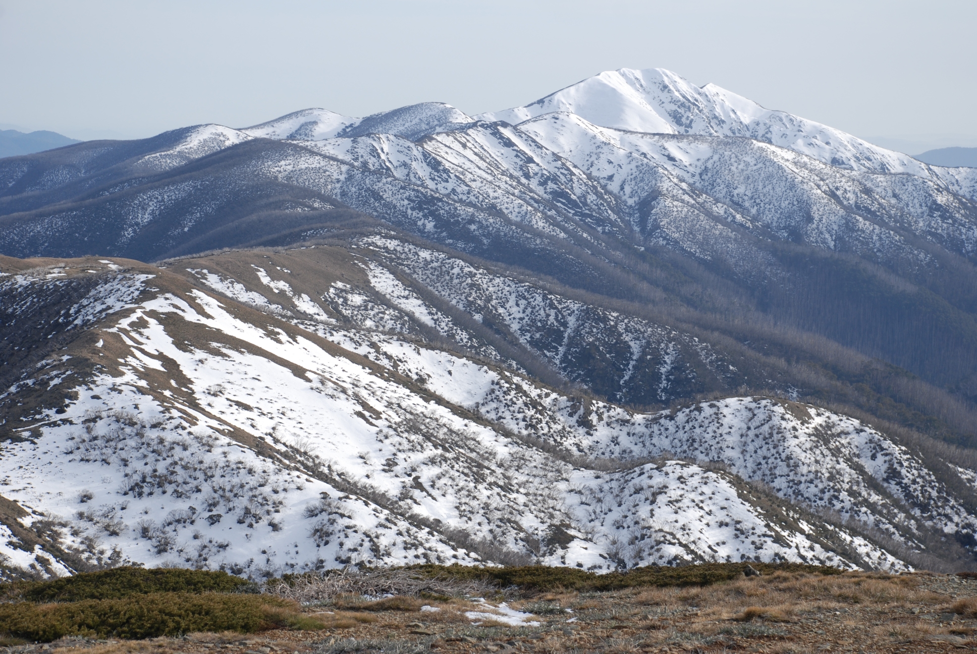
The Australian Alps are a mountain range in southeast Australia. The range comprises an interim Australian bioregion, and is the highest mountain range on mainland Australia. The range straddles the borders of eastern Victoria, southeastern New South Wales, and the Australian Capital Territory. It contains the only peaks exceeding 2,000 m (6,600 ft) in elevation on the Australian mainland, and is the only bioregion on the Australian mainland in which deep snow falls annually. The range comprises an area of 1,232,981 ha (3,046,760 acres).
The Australian Alps are part of the Great Dividing Range, the series of mountain and hill ranges and tablelands that runs about 3,000 km (1,900 mi) from northern Queensland, through New South Wales, and into the northern part of Victoria. This chain of highlands divides the drainage of the rivers that flow to the east into the Pacific Ocean from those that flow west into the drainage of the Murray–Darling Basin (and thence to the Southern Ocean) or into inland waters, such as Lake Eyre, which lie below sea level, or else evaporate rapidly.
The Australian Alps consist of two biogeographic sub regions: the Snowy Mountains, including the Brindabella Range, located in New South Wales and the Australian Capital Territory; and the Victorian Alps, located in Victoria. The latter region is also known as the "High Country", particularly within a cultural or historical context.
Unlike the high mountain ranges found in places like the Rockies (highest peak 4,401 m (14,439 ft)), the European Alps (highest peak 4,808 m (15,774 ft)) or the Himalayas (highest peak 8,848 m (29,029 ft)), the Australian Alps were not formed by two continental plates colliding and pushing up the Earth's rocky mantle to form jagged, rocky peaks. Instead, the Australian Alps consist of a high plateau, with significantly softer rolling hills spread across a long, wide plateau that was lifted thousands of feet up by the movement of magma when Gondwana began to break up between 130 and 160 million years ago. The highest peak in the Australian Alps is Mount Kosciuszko (2,228 metres (7,310 ft)).
Formation of the Australian Alps was largely complete by around 100 million years ago, but during the past 90 million years, a number of minor uplift episodes occurred, with occasional eruptions of basalt lava from small volcanoes, which flowed across the landscape and down some of the valleys, filling in the low-lying areas to form the flat landscapes of these high plains.
During the Pleistocene ice age, commencing around 2 million years ago, when ice caps formed on many high ranges around the world, as well as at the poles, small glaciers were formed on the very highest parts of the Australian Alps, mostly in the vicinity of Mount Kosciuszko. Whilst no glaciers remain today, evidence of their past presence can be found in the numerous tarns and cirques found in that region, such as Club Lake, Blue Lake, and Hedley Tarn.
The Australian Alps are important for conservation, recreation, and as a water drainage basin, with much of the range's eastern slopes having its runoff diverted artificially into the Murray River and its tributary the Murrumbidgee River through the civil engineering project of the Snowy Mountains Scheme.
The range's natural ecology is protected by large national parks, in particular the Kosciuszko National Park in New South Wales and the adjoining Alpine National Park in Victoria. These are managed cooperatively as the Australian Alps National Parks by agencies of the Australian government and the state governments of this region.
Hub AI
Australian Alps AI simulator
(@Australian Alps_simulator)
Australian Alps
The Australian Alps are a mountain range in southeast Australia. The range comprises an interim Australian bioregion, and is the highest mountain range on mainland Australia. The range straddles the borders of eastern Victoria, southeastern New South Wales, and the Australian Capital Territory. It contains the only peaks exceeding 2,000 m (6,600 ft) in elevation on the Australian mainland, and is the only bioregion on the Australian mainland in which deep snow falls annually. The range comprises an area of 1,232,981 ha (3,046,760 acres).
The Australian Alps are part of the Great Dividing Range, the series of mountain and hill ranges and tablelands that runs about 3,000 km (1,900 mi) from northern Queensland, through New South Wales, and into the northern part of Victoria. This chain of highlands divides the drainage of the rivers that flow to the east into the Pacific Ocean from those that flow west into the drainage of the Murray–Darling Basin (and thence to the Southern Ocean) or into inland waters, such as Lake Eyre, which lie below sea level, or else evaporate rapidly.
The Australian Alps consist of two biogeographic sub regions: the Snowy Mountains, including the Brindabella Range, located in New South Wales and the Australian Capital Territory; and the Victorian Alps, located in Victoria. The latter region is also known as the "High Country", particularly within a cultural or historical context.
Unlike the high mountain ranges found in places like the Rockies (highest peak 4,401 m (14,439 ft)), the European Alps (highest peak 4,808 m (15,774 ft)) or the Himalayas (highest peak 8,848 m (29,029 ft)), the Australian Alps were not formed by two continental plates colliding and pushing up the Earth's rocky mantle to form jagged, rocky peaks. Instead, the Australian Alps consist of a high plateau, with significantly softer rolling hills spread across a long, wide plateau that was lifted thousands of feet up by the movement of magma when Gondwana began to break up between 130 and 160 million years ago. The highest peak in the Australian Alps is Mount Kosciuszko (2,228 metres (7,310 ft)).
Formation of the Australian Alps was largely complete by around 100 million years ago, but during the past 90 million years, a number of minor uplift episodes occurred, with occasional eruptions of basalt lava from small volcanoes, which flowed across the landscape and down some of the valleys, filling in the low-lying areas to form the flat landscapes of these high plains.
During the Pleistocene ice age, commencing around 2 million years ago, when ice caps formed on many high ranges around the world, as well as at the poles, small glaciers were formed on the very highest parts of the Australian Alps, mostly in the vicinity of Mount Kosciuszko. Whilst no glaciers remain today, evidence of their past presence can be found in the numerous tarns and cirques found in that region, such as Club Lake, Blue Lake, and Hedley Tarn.
The Australian Alps are important for conservation, recreation, and as a water drainage basin, with much of the range's eastern slopes having its runoff diverted artificially into the Murray River and its tributary the Murrumbidgee River through the civil engineering project of the Snowy Mountains Scheme.
The range's natural ecology is protected by large national parks, in particular the Kosciuszko National Park in New South Wales and the adjoining Alpine National Park in Victoria. These are managed cooperatively as the Australian Alps National Parks by agencies of the Australian government and the state governments of this region.
Recent media