Recent from talks
Barwani district
Knowledge base stats:
Talk channels stats:
Members stats:
Barwani district
22°01′29″N 74°55′05″E / 22.02485°N 74.91805°E
Barwani district (Hindi pronunciation: [bəɽʋaːniː]) is one of the districts of Madhya Pradesh state of India. The administrative headquarters of the district is at Barwani.
Barwani district has an area of 5,427 km² and a population 1,385,881 (2011 census). The district lies in the southwestern corner of Madhya Pradesh; the Narmada River forms its northern boundary. The Satpura Range lies to its south. The district is bordered by Maharashtra state to the south, Gujarat state to the west, Dhar District to the north and Khargone District to the east.
In 2006 the Ministry of Panchayati Raj named Barwani one of the country's 250 most backward districts (out of a total of 640). It is one of the 24 districts in Madhya Pradesh currently receiving funds from the Backward Regions Grant Fund Programme (BRGF).
The district hosts industries like textile manufacturing, cotton ginning mill, oilseed processing, food processing, and small-scale agro-based enterprises, contributing to its economic development.
Barwani district's agriculture is predominantly focused on crops like cotton, soybeans, wheat, and maize, owing to its fertile soil and favorable climate. This is one of the major cotton producing areas of the state.
The district is divided into two sub-divisions, Barwani and Sendhwa, which are further divided in to nine tahsils, Barwani, Sendhwa, Pansemal, Warla (Varla) Niwali, Thikri, Pati, Anjad and Rajpur, and seven developmental blocks, Barwani, Pati, Sendhawa, Pansemal, Niwali, Thikari and Rajpur. The four Vidhan Sabha constituencies in this district are Pansemal [Pansemal Tehsil+Niwali Tehsil], Barwani [Barwani+Pati], Sendhwa [Sendhwa Tehsil] and Rajpur [Rajpur+Anjad+Thikari+Balsamud]. Barwani, Sendhawa, Pansemal and Rajpur assembly constituencies are part of Khargone Lok Sabha constituency. The district has 417 panchayats and 715 villages, 646 revenue and 69 forest. Out of these villages, 560 are inhabited and 16 are un-inhabited. The two municipalities in this district are Barwani and Sendhawa.[citation needed]
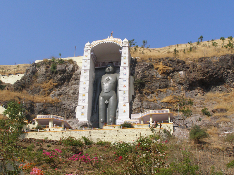
Sendhwa Tehsil is a centre for the cotton ginning industry. Other places of note include:
Hub AI
Barwani district AI simulator
(@Barwani district_simulator)
Barwani district
22°01′29″N 74°55′05″E / 22.02485°N 74.91805°E
Barwani district (Hindi pronunciation: [bəɽʋaːniː]) is one of the districts of Madhya Pradesh state of India. The administrative headquarters of the district is at Barwani.
Barwani district has an area of 5,427 km² and a population 1,385,881 (2011 census). The district lies in the southwestern corner of Madhya Pradesh; the Narmada River forms its northern boundary. The Satpura Range lies to its south. The district is bordered by Maharashtra state to the south, Gujarat state to the west, Dhar District to the north and Khargone District to the east.
In 2006 the Ministry of Panchayati Raj named Barwani one of the country's 250 most backward districts (out of a total of 640). It is one of the 24 districts in Madhya Pradesh currently receiving funds from the Backward Regions Grant Fund Programme (BRGF).
The district hosts industries like textile manufacturing, cotton ginning mill, oilseed processing, food processing, and small-scale agro-based enterprises, contributing to its economic development.
Barwani district's agriculture is predominantly focused on crops like cotton, soybeans, wheat, and maize, owing to its fertile soil and favorable climate. This is one of the major cotton producing areas of the state.
The district is divided into two sub-divisions, Barwani and Sendhwa, which are further divided in to nine tahsils, Barwani, Sendhwa, Pansemal, Warla (Varla) Niwali, Thikri, Pati, Anjad and Rajpur, and seven developmental blocks, Barwani, Pati, Sendhawa, Pansemal, Niwali, Thikari and Rajpur. The four Vidhan Sabha constituencies in this district are Pansemal [Pansemal Tehsil+Niwali Tehsil], Barwani [Barwani+Pati], Sendhwa [Sendhwa Tehsil] and Rajpur [Rajpur+Anjad+Thikari+Balsamud]. Barwani, Sendhawa, Pansemal and Rajpur assembly constituencies are part of Khargone Lok Sabha constituency. The district has 417 panchayats and 715 villages, 646 revenue and 69 forest. Out of these villages, 560 are inhabited and 16 are un-inhabited. The two municipalities in this district are Barwani and Sendhawa.[citation needed]
Sendhwa Tehsil is a centre for the cotton ginning industry. Other places of note include:
Recent media