

Community hub
Recent from talks
Contribute something
Nothing was collected or created yet.
Barwani
View on WikipediaThis article needs additional citations for verification. (August 2020) |
Barwani or Badwani (Hindi: Baḍwāni) is a municipal town in Barwani district of Madhya Pradesh, India, that is situated near the left bank of the Narmada River. It is the administrative headquarters of Barwani district and has also served as the capital of the former princely state of Barwani. Barwani is only accessible by road.
Key Information


Origin of name
[edit]The name Barwani originated from the words Bad and Wani. The Forests of "Bad" surrounded the city in old times and "Wani" is an old word meaning "the garden", translating to the Garden of Bad. Despite its official spelling, Barwani is pronounced as "Badwani".[1]
Geography
[edit]
Barwani is located at 22°02′N 74°54′E / 22.03°N 74.9°E.[2] It has an average elevation of 178 meters (583 feet). The Narmada River flows through Barwani; it is 5 km (3.1 miles) from the city centre. The maximum temperature of Barwani in April and May used to reach 48 °C (118 °F), making it one of the hottest places in Central India. However, in recent years, it has cooled down.[citation needed]

The hills of the Satpura Range surround Barwani. The city is also called the "Paris of Nimar" ("area beyond Neem trees").[3] Nimar is split into East Nimar and West Nimar; Barwani lies in West Nimar. The annual rainfall of Barwani is around 15 in (38 cm), though since 2006 it has increased significantly.[citation needed] Barwani is famous for its papayas and Bawangaja, a Jain holy place 8 km (5.0 miles) from Barwani.
Transport
[edit]
Barwani has no immediate connectivity through rail but is easily accessible via roadways.[citation needed] The nearest airport is indore.
Railways
[edit]Barwani has no direct rail connectivity the nearest station to the town is at Indore. Western Railways (Ratlam Mandal) has a reservation counter in Ambedkar Park on Rajghat Road. There is also a railway station at Khandwa on the Central Railway, which is 180 km (110 miles) from Barwani via State Highway 26.[4]
Roads
[edit]Barwani is well connected to other parts of Madhya Pradesh and other states via national and state highways. The town is connected to the Agra-Bombay national highway number three by the Khandwa-Baroda interstate highway no. 26 at a distance of 51 km (32 miles) at Thikri. Bus services connect the town with the major and minor cities near Barwani, including Indore, Khandwa, Dhar, Barwaha, Khargone, Mumbai, Ahmedabad, and Vadodara.[citation needed]
Demographics
[edit]As of the 2011 Census of India,[4] Barwani had a population of 55,504, consisting of 28,437 males (51%) and 27,067 females (49%).
The population of children aged 0–6 was 6,961 (12.54%). In Barwani Municipality, the male-to-female sex ratio is 1,000:952 against the state average of 1,000:931. The child male-to-female sex ratio in Barwani is around 1000:919, compared with the Madhya Pradesh state average of 1000:918. The literacy rate of Barwani City is 82.10% compared with the state's average of 69.32%. In Barwani, male literacy is around 87.17%, while the female literacy rate is 76.80%.[citation needed]
Schedule Tribes (ST) constitutes 23.29% while Schedule Castes (SC) were 9.95% of the population in Barwani.[5]
Out of the total population, 18,438 were engaged in work or business activity. Of these, 13,957 were males and 4,481 were females. In a census survey, a worker is defined as a person who does business, job, service, and cultivator and labour activity. With 18,438 people in the working population, 89.06% were engaged in Main Work while 10.94% of total workers were engaged in marginal work.[5]
Economy
[edit]While Barwani is not heavily industrialized, it does have some industries, including those producing electronic products and heavy machinery. Economically, Barwani engages in agricultural crops and wood,[6] with several other small industries developing in the area. Barwani mainly has edible oil mills and cotton ginning factories which are the mainstay of the economy.Small-scale agro-based enterprises contribute to the district's economic development.[7]
Culture
[edit]Main festivals
[edit]The major festivals of Holi, Raksha Bandhan, Ganesh Utsav, Navratri, Dussehra, Deepavali, Muharram, Gudi Padwa, Gangaur, Bhai Dooj, Eid al-Fitr and Eid al-Adha, Christmas and Naga Panchami are all celebrated with equal enthusiasm. Barwani is known for jhakis (झाकी) (glimpse or view) during Ganesh Utsav and Tajiye during Muharram.[citation needed]
Places of interest
[edit]- Bawangaja (Jain Mandir) is a temple.
- Rajghat (Narmada River) is a significant ghat of Narmada River, A ghat on the Narmada River, offering a peaceful atmosphere.
- Sawariya Seth Mandir.[8]
- Tir Gola, located on Khandwa-Baroda Road, built in memory of the late son of Raja Ranjit Singh.[9]
Healthcare
[edit]Barwani is prominent in the Nimar and Malwa regions for its healthcare facilities and its private hospitals. Barwani District Hospital is one of the oldest hospitals in Madhya Pradesh.[circular reference]
Notable people
[edit]- Dr. Anil Kakodkar - India's eminent nuclear physicist, and former chairman of the Atomic Energy Commission of India and the Secretary to the Government of India, Department of Atomic Energy, was born in Barwani.
- Sumer Singh Solanki A Indian Politician
- Bhima Nayak, an Indian revolutionary
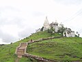
Gallery
[edit]-
 Vaishno Devi Mandir during festival, Barwani
 -
 84 feet tall, huge statue of Bhagwan Rishabhadeva at Bawangaja
 -
 Beauty of Satpura Hills
 -
 Beautiful Satpura Hills, Barwani
 -
-
 Choolgiri View from forest point
 -
 MAA VAISHNO DEVI MANDIR


References
[edit]- ^ "Barwani/District Court in India | Official Website of District Court of India". districts.ecourts.gov.in. Retrieved 26 July 2020.
- ^ Falling Rain Genomics, Inc - Barwani
- ^ "Profile | District Barwani, Government of Madhya Pradesh | India". Retrieved 30 July 2020.
- ^ a b "Census of India 2011: Data from the 2011 Census, including cities, villages and towns (Provisional)". Census Commission of India. Retrieved 18 June 2015.
- ^ a b "Barwani Municipality City Population Census 2011-2022 | Madhya Pradesh".
- ^ "Barwani | India". Encyclopedia Britannica. Retrieved 31 July 2020.
- ^ "District Industrial Potential Survey Report of Barwani District Madhya Pradesh And Industrial Development Plan" (PDF).
- ^ "बड़वानी के श्री सांवरिया सेठ मंदिर में 21 फरवरी से होगा छठा अमृत महोत्सव". Patrika News (in Hindi). Retrieved 23 July 2025.
- ^ "जानिए… क्या है तीर-गोले का इतिहास, किसकी याद में कराया था निर्माण". Patrika News (in Hindi). Retrieved 23 July 2025.
| Authority control databases: National |
|---|
Barwani
View on GrokipediaBarwani is a district in southwestern Madhya Pradesh, India, encompassing 5,427 square kilometres of terrain bordered by the Narmada River to the south and featuring the Satpura and Vindhya mountain ranges along with extensive forests.[1][2]
Established on 25 May 1998 by bifurcation from Khargone district, it has Barwani town as its administrative headquarters, a historical settlement formerly known as the capital of the princely state of Barwani until India's independence and subsequent merger in 1948.[3][4]
As of the 2011 census, the district's population stood at 1,385,881, with 699,340 males and 686,541 females, of which 1,181,812 resided in rural areas and 204,069 in urban settings, reflecting a predominantly tribal and agrarian demographic engaged in agriculture, timber trade, and cotton processing.[5][6]
The region is noted for natural landmarks such as the Choolgiri hills and Jain pilgrimage sites including Bawangaja, alongside scenic riverine and forested landscapes that define its ecological and cultural character.[3][7]
Etymology and History
Origin of the Name
The name Barwani (also spelled Badwani) derives from the Hindi words bad (बड़), denoting the banyan tree (Ficus benghalensis), and wani (वनी), an archaic term for garden or wooded area.[1][8] This etymology reflects the region's historical landscape, which was enveloped by extensive forests dominated by banyan trees in ancient times.[9][10] Local historical accounts emphasize that these bad forests formed a natural enclosure around the original settlement, with wani signifying the verdant, garden-like quality of the terrain along the Narmada River valley.[3] The term thus conveys "banyan forest" or "garden of banyans," underscoring the ecological prominence of these trees prior to extensive deforestation and urbanization.[8] No alternative derivations, such as from rulers or events, appear in primary regional records, establishing this botanical origin as the predominant explanation.[9]Pre-Colonial and Princely State Era
The Barwani region, situated in the Narmada Valley of the Nimar area, was traditionally founded as a princely state in 836 AD by a Sisodia prince from Mewar who migrated southward, establishing rule over the hilly terrain predominantly inhabited by Bhil tribals.[11] [9] Alternative accounts place the founding in the 14th century, reflecting uncertainties in early records, but the Sisodia lineage traces descent from the Rajput rulers of Udaipur.[11] The rulers, titled Rana, belonged to the Sisodiya (or Shishodhya) dynasty and governed a fragmented territory characterized by rocky, forested landscapes that provided natural defenses.[12] [3] During the medieval and early modern periods, Barwani evaded direct conquest by major powers, including the Mughals and Marathas, owing to its defensible geography and limited strategic value despite proximity to trade routes along the Narmada River.[3] By the 17th century, the state had solidified under Rana Jodh Singh (r. circa 1675–1700), marking the beginning of documented Sisodiya consolidation amid regional feudal dynamics.[13] The princely state maintained internal autonomy, with the ruling family overseeing a small military force including cavalry, infantry, and artillery, while deriving revenue from agriculture and tribal tributes in the Malwa Plateau fringes.[14] Under British paramountcy from the early 19th century, Barwani fell within the Bhopawar Agency of the Central India Agency, receiving an 11-gun salute as a recognized salute state, though it experienced brief direct British administration between 1861 and 1873 due to internal succession disputes.[12] [13] The Rana's court at Barwani town, established around 1650 as the capital, functioned with Rajput traditions intact, including alliances with neighboring states like Indore and Dewas.[15] Forests remained under nominal British oversight for resource management, but local governance preserved Sisodiya customs until accession to the Union of India in 1948, integrating Barwani into Madhya Bharat.[14]Post-Independence Formation and Developments
Following India's independence in 1947, the princely state of Barwani acceded to the Union of India on 15 June 1948.[14] The state was subsequently merged into the Union of Madhya Bharat on 29 June 1948 through a covenant, becoming part of its Nimar district.[16] This integration marked the end of Barwani's independent status as a 11-gun salute princely state under Sisodia Rajput rule, transitioning its administration to the centralized framework of post-independence India.[14] Under the States Reorganisation Act of 1956, Madhya Bharat was reorganized and merged into the enlarged state of Madhya Pradesh effective 1 November 1956, with Barwani's territories incorporated into the West Nimar district (later renamed Khargone district).[3] This realignment aligned the region with linguistic and administrative boundaries, placing Barwani under Madhya Pradesh's governance while retaining its position along the Narmada River as a peripheral area with significant tribal populations.[3] Administrative developments continued with the creation of Barwani as a separate district on 25 May 1998, carved out from the western portion of Khargone district to address local governance needs in the southwestern Madhya Pradesh region.[3] [9] The new district encompassed an area of approximately 5,427 square kilometers, focusing administrative resources on the area's agricultural and tribal-dominated economy, though it inherited challenges such as infrastructure deficits common to post-independence rural integrations.[3] This bifurcation enhanced localized decision-making, separating Barwani's hilly terrains and Narmada-border areas from Khargone's core.[9]Geography
Location and Physical Features
Barwani district is situated in the southwestern region of Madhya Pradesh, India, spanning latitudes 21°37′ N to 22°22′ N and longitudes 74°27′ E to 75°30′ E.[3] The district covers a geographical area of 5,422 square kilometers.[17] It is bordered to the north by the Narmada River, which serves as its northern boundary, and to the south by the Satpura hills.[17][3] To the east lies Khargone district, while the western boundaries adjoin Jhabua and Dhar districts of Madhya Pradesh along with portions of Gujarat state.[17] The physical landscape of Barwani district features undulating terrain dominated by the Satpura mountain range in the south, creating hilly and valley formations.[17] The region is primarily drained by the Narmada River and its tributaries, including the Goi and Deb rivers, which flow southward to northward into the Narmada.[17] Predominant soil types consist of medium black cotton soils, comprising approximately 50% silt and clay.[17] The town of Barwani, serving as the district headquarters, is positioned along the southwestern edge of Madhya Pradesh proximate to the Narmada River.[3] This positioning integrates the district's topography, where the riverine plains meet the encroaching Satpura elevations, influencing local hydrology and landforms.[17]Climate and Environmental Conditions
Barwani district has a tropical climate that is predominantly dry, except during the southwest monsoon season from mid-June to September. Summers are intensely hot, with May recording average high temperatures of 41°C (105°F) and lows around 27°C (81°F). Winters remain mild, spanning December to February, with daytime highs of 24–28°C and minimum temperatures falling to approximately 11°C (52°F) in January.[18][17] Annual rainfall averages 746.3 mm, concentrated in the monsoon period, with July seeing the peak at about 200 mm. Historical data indicate a 22.88% rise in average rainfall from 1901–1930 compared to prior baselines, followed by relative stability. The district occasionally experiences extreme weather, including heat waves in summer and potential flooding along the Narmada River during heavy monsoons.[5][19] Environmentally, Barwani encompasses the Narmada River basin and segments of the Satpura ranges, fostering riparian and hill ecosystems with moderate biodiversity. Forest cover totals 244.09 km² in a district area of 5,429 km², equating to roughly 4.5% dense and open forest, while overall green cover reaches 17.10%. Challenges include forest fire vulnerability in drier zones and degradation from historical deforestation, reducing original forest extent by up to 93% in some sub-regions since 1908. The Madhya Pradesh Pollution Control Board notes ongoing efforts to address air and water quality amid agricultural and limited industrial pressures.[19][17]Demographics
Population and Growth Trends
According to the 2011 Census of India, Barwani district had a total population of 1,385,881, comprising 699,340 males and 686,541 females, yielding a sex ratio of 982 females per 1,000 males.[5][6] The population density stood at 255 persons per square kilometer across the district's 5,427 square kilometers.[5] The district recorded a decennial population growth rate of 27.57% between 2001 and 2011, surpassing the Madhya Pradesh state average of approximately 20.3% and the national average of 17.7% during the same period.[5][6] This elevated growth reflects factors such as high fertility rates in rural and tribal-dominated areas, where 85.28% of the population resides, compared to 14.72% in urban regions.[20][6] Projections based on the 2011 growth trajectory estimate the district's population at around 1,790,000 in 2024, though official census updates remain pending due to the deferral of India's 2021 enumeration.[20] Sustained high growth could strain resources in this predominantly agrarian and tribal region, underscoring the need for targeted demographic interventions.[5]Literacy Rates and Educational Attainment
According to the 2011 Census of India, Barwani district recorded an overall literacy rate of 49.09 percent, substantially below the national average of 72.99 percent at the time. Male literacy was 57.41 percent, while female literacy lagged at 40.65 percent, highlighting a significant gender disparity influenced by the district's rural-tribal demographics and limited access to education in remote areas. Rural literacy stood at 43.74 percent, compared to higher urban rates, underscoring infrastructural challenges in serving the predominantly adivasi (tribal) population.[6][20]| Literacy Category | Rate (%) |
|---|---|
| Overall | 49.09 |
| Male | 57.41 |
| Female | 40.65 |
| Rural | 43.74 |