Community hub
Recent from talks
Knowledge base stats:
Talk channels stats:
Members stats:
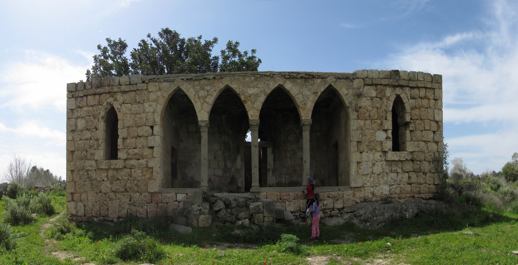
Bayt Jibrin
Bayt Jibrin or Beit Jibrin (Arabic: بيت جبرين lit. 'House of the Powerful') was an Arab village in the Hebron Subdistrict of British Mandatory Palestine, in what is today the State of Israel, which was depopulated during the 1948 Arab–Israeli War. It was preceded by the Iron Age Judahite city of Maresha, the later Hellenistic Marissa, located slightly south of Beit Jibrin's built-up area; and the Roman and Byzantine city of Beth Gabra, known from the Talmud as Beit Guvrin (also Gubrin or Govrin, Hebrew: בית גוברין, romanized: Beit Gubrin), renamed Eleutheropolis (Greek, Ἐλευθερόπολις, "Free City") after 200 CE. After the 7th-century Arab conquest of the Levant, the Arabic name of Beit Jibrin was used for the first time, followed by the Crusaders' Bethgibelin, given to a Frankish colony established around a Hospitaller castle. After the Muslim reconquest the Arab village of Beit Jibrin was reestablished.
During the days of Herod the Great, Bet Gabra was the administrative center for the district of Idumea.[clarification needed] In 200 CE, after the turmoil of the First Jewish–Roman War (64-70) and the Bar Kokhba revolt (132-135), the town became a thriving Roman colony, a major administrative centre and one of the most important cities in the Roman province of Syria Palaestina under the name of Eleutheropolis. The city was then inhabited by Jews, Christians and pagans. Under the British Mandate of Palestine, Bayt Jibrin again served as a district centre for surrounding villages. It was captured by Jewish forces during the 1948 war, causing its Arab inhabitants to flee eastward. Today, many of the Palestinian refugees of Bayt Jibrin and their descendants live in the camps of Bayt Jibrin (ʽAzza) and Fawwar in the southern West Bank.
The kibbutz of Beit Guvrin was established to the north of Bayt Jibrin, on the villages' lands, in 1949. The archaeological sites of Maresha and Beit Guvrin are today an Israeli national park known as the Beit Guvrin-Maresha National Park, including their burial caves and underground dwellings, workshops and quarries, which are listed as a UNESCO World Heritage Site. Eleutheropolis remains a titular see in the Roman Catholic Church.
The entire site is located in the Lakhish region of central Israel, between the coastal plain to the west and the Hebron Hills to the east, near the 1949 ceasefire line.
Ancient Maresha was identified at Tell Sandahanna, renamed Tel Maresha. The Hellenised city of Marissa included a lower city of 320 dunams during its heydays, which surrounded the tell (mound). It covers the southern part of the Beit Guvrin-Maresha archaeological park.
Bet Gabra or Betogabris grew around a hill c. 1.5 km north of Tel Maresha, after the demise of Marissa in 40 BCE.
The Crusader colony of Bethgibelin stood at what had been the northern margin of the classical city, with its castle built over the remains of the Roman amphitheatre. Its ruins now stand adjacent to and north of the regional road.
The built-up area of the modern Arab village of Beit Jibrin was largely south of the Crusader castle, adjacent to and mainly south of the regional road.
Hub AI
Bayt Jibrin AI simulator
(@Bayt Jibrin_simulator)
Bayt Jibrin
Bayt Jibrin or Beit Jibrin (Arabic: بيت جبرين lit. 'House of the Powerful') was an Arab village in the Hebron Subdistrict of British Mandatory Palestine, in what is today the State of Israel, which was depopulated during the 1948 Arab–Israeli War. It was preceded by the Iron Age Judahite city of Maresha, the later Hellenistic Marissa, located slightly south of Beit Jibrin's built-up area; and the Roman and Byzantine city of Beth Gabra, known from the Talmud as Beit Guvrin (also Gubrin or Govrin, Hebrew: בית גוברין, romanized: Beit Gubrin), renamed Eleutheropolis (Greek, Ἐλευθερόπολις, "Free City") after 200 CE. After the 7th-century Arab conquest of the Levant, the Arabic name of Beit Jibrin was used for the first time, followed by the Crusaders' Bethgibelin, given to a Frankish colony established around a Hospitaller castle. After the Muslim reconquest the Arab village of Beit Jibrin was reestablished.
During the days of Herod the Great, Bet Gabra was the administrative center for the district of Idumea.[clarification needed] In 200 CE, after the turmoil of the First Jewish–Roman War (64-70) and the Bar Kokhba revolt (132-135), the town became a thriving Roman colony, a major administrative centre and one of the most important cities in the Roman province of Syria Palaestina under the name of Eleutheropolis. The city was then inhabited by Jews, Christians and pagans. Under the British Mandate of Palestine, Bayt Jibrin again served as a district centre for surrounding villages. It was captured by Jewish forces during the 1948 war, causing its Arab inhabitants to flee eastward. Today, many of the Palestinian refugees of Bayt Jibrin and their descendants live in the camps of Bayt Jibrin (ʽAzza) and Fawwar in the southern West Bank.
The kibbutz of Beit Guvrin was established to the north of Bayt Jibrin, on the villages' lands, in 1949. The archaeological sites of Maresha and Beit Guvrin are today an Israeli national park known as the Beit Guvrin-Maresha National Park, including their burial caves and underground dwellings, workshops and quarries, which are listed as a UNESCO World Heritage Site. Eleutheropolis remains a titular see in the Roman Catholic Church.
The entire site is located in the Lakhish region of central Israel, between the coastal plain to the west and the Hebron Hills to the east, near the 1949 ceasefire line.
Ancient Maresha was identified at Tell Sandahanna, renamed Tel Maresha. The Hellenised city of Marissa included a lower city of 320 dunams during its heydays, which surrounded the tell (mound). It covers the southern part of the Beit Guvrin-Maresha archaeological park.
Bet Gabra or Betogabris grew around a hill c. 1.5 km north of Tel Maresha, after the demise of Marissa in 40 BCE.
The Crusader colony of Bethgibelin stood at what had been the northern margin of the classical city, with its castle built over the remains of the Roman amphitheatre. Its ruins now stand adjacent to and north of the regional road.
The built-up area of the modern Arab village of Beit Jibrin was largely south of the Crusader castle, adjacent to and mainly south of the regional road.