Recent from talks
Caribbean plate
Knowledge base stats:
Talk channels stats:
Members stats:
Caribbean plate
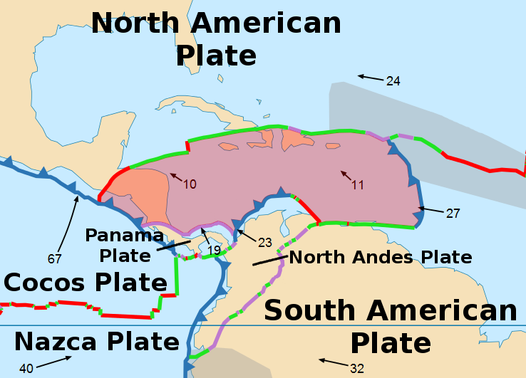
The Caribbean plate is a mostly oceanic tectonic plate underlying Central America and the Caribbean Sea off the northern coast of South America.
Roughly 3.2 million square kilometres (1.2 million square miles) in area, the Caribbean plate borders the North American plate, the South American plate, the Nazca plate and the Cocos plate. These borders are regions of intense seismic activity, including frequent earthquakes, occasional tsunamis, and volcanic eruptions.
The northern boundary with the North American plate is a transform or strike-slip boundary that runs from the border area of Belize, Guatemala (Motagua Fault), and Honduras in Central America, eastward through the Cayman trough along the Swan Islands Transform Fault before joining the southern boundary of the Gonâve microplate. East of the Mid-Cayman Rise this continues as the Walton fault zone and the Enriquillo–Plantain Garden fault zone into eastern Hispaniola. From there it continues into Puerto Rico, and the Virgin Islands. Part of the Puerto Rico Trench, the deepest part of the Atlantic Ocean (roughly 8,400 metres or 27,600 feet), lies along this border. The Puerto Rico Trench is at a complex transition from the subduction boundary to the south and the transform boundary to the west.
The eastern boundary is a subduction zone, the Lesser Antilles subduction zone, where oceanic crust of the South American plate is being subducted under the Caribbean plate. Subduction forms the volcanic islands of the Lesser Antilles Volcanic Arc from the Virgin Islands in the north to the islands off the coast of Venezuela in the south. This boundary contains seventeen active volcanoes, most notably Soufriere Hills on Montserrat; Mount Pelée on Martinique; La Grande Soufrière on Guadeloupe; Soufrière Saint Vincent on Saint Vincent; and the submarine volcano Kick 'em Jenny which lies about 10 km north of Grenada. Large historical earthquakes in 1839 and 1843 in this region are possibly megathrust earthquakes.
Along the geologically complex southern boundary, the Caribbean plate interacts with the South American plate forming Barbados, Trinidad and Tobago (all on the Caribbean plate), and islands off the coast of Venezuela (including the Leeward Antilles) and Colombia. This boundary is in part the result of transform faulting, along with thrust faulting and some subduction. The rich Venezuelan petroleum fields possibly result from this complex plate interaction. The Caribbean plate is moving eastward about 22 millimetres (0.87 in) per year in relation to the South American plate. In Venezuela, much of the movement between the Caribbean plate and the South American plate occurs along the faults of Boconó, El Pilar, and San Sebastián.
The western portion of the plate is occupied by Central America. The Cocos plate in the Pacific Ocean is subducted beneath the Caribbean plate, just off the western coast of Central America. This subduction forms the volcanoes of Guatemala, El Salvador, Nicaragua, and Costa Rica, also known as the Central America Volcanic Arc.
The usual theory of the origin of the Caribbean plate was confronted by a contrasting theory in 2002.
The mainstream theory holds that it is the Caribbean large igneous province (CLIP) which formed in the Pacific Ocean tens of millions of years ago, perhaps originating at the Galápagos hotspot. As the Atlantic Ocean widened, North America and South America were pushed westward, separated for a time by oceanic crust. The Pacific Ocean floor subducted under this oceanic crust between the continents. The CLIP drifted into the same area, but as it was less dense and thicker than the surrounding oceanic crust, it did not subduct, but rather overrode the ocean floor, continuing to move eastward relative to North America and South America. With the formation of the Isthmus of Panama 3 million years ago, it ultimately lost its connection to the Pacific.
Hub AI
Caribbean plate AI simulator
(@Caribbean plate_simulator)
Caribbean plate
The Caribbean plate is a mostly oceanic tectonic plate underlying Central America and the Caribbean Sea off the northern coast of South America.
Roughly 3.2 million square kilometres (1.2 million square miles) in area, the Caribbean plate borders the North American plate, the South American plate, the Nazca plate and the Cocos plate. These borders are regions of intense seismic activity, including frequent earthquakes, occasional tsunamis, and volcanic eruptions.
The northern boundary with the North American plate is a transform or strike-slip boundary that runs from the border area of Belize, Guatemala (Motagua Fault), and Honduras in Central America, eastward through the Cayman trough along the Swan Islands Transform Fault before joining the southern boundary of the Gonâve microplate. East of the Mid-Cayman Rise this continues as the Walton fault zone and the Enriquillo–Plantain Garden fault zone into eastern Hispaniola. From there it continues into Puerto Rico, and the Virgin Islands. Part of the Puerto Rico Trench, the deepest part of the Atlantic Ocean (roughly 8,400 metres or 27,600 feet), lies along this border. The Puerto Rico Trench is at a complex transition from the subduction boundary to the south and the transform boundary to the west.
The eastern boundary is a subduction zone, the Lesser Antilles subduction zone, where oceanic crust of the South American plate is being subducted under the Caribbean plate. Subduction forms the volcanic islands of the Lesser Antilles Volcanic Arc from the Virgin Islands in the north to the islands off the coast of Venezuela in the south. This boundary contains seventeen active volcanoes, most notably Soufriere Hills on Montserrat; Mount Pelée on Martinique; La Grande Soufrière on Guadeloupe; Soufrière Saint Vincent on Saint Vincent; and the submarine volcano Kick 'em Jenny which lies about 10 km north of Grenada. Large historical earthquakes in 1839 and 1843 in this region are possibly megathrust earthquakes.
Along the geologically complex southern boundary, the Caribbean plate interacts with the South American plate forming Barbados, Trinidad and Tobago (all on the Caribbean plate), and islands off the coast of Venezuela (including the Leeward Antilles) and Colombia. This boundary is in part the result of transform faulting, along with thrust faulting and some subduction. The rich Venezuelan petroleum fields possibly result from this complex plate interaction. The Caribbean plate is moving eastward about 22 millimetres (0.87 in) per year in relation to the South American plate. In Venezuela, much of the movement between the Caribbean plate and the South American plate occurs along the faults of Boconó, El Pilar, and San Sebastián.
The western portion of the plate is occupied by Central America. The Cocos plate in the Pacific Ocean is subducted beneath the Caribbean plate, just off the western coast of Central America. This subduction forms the volcanoes of Guatemala, El Salvador, Nicaragua, and Costa Rica, also known as the Central America Volcanic Arc.
The usual theory of the origin of the Caribbean plate was confronted by a contrasting theory in 2002.
The mainstream theory holds that it is the Caribbean large igneous province (CLIP) which formed in the Pacific Ocean tens of millions of years ago, perhaps originating at the Galápagos hotspot. As the Atlantic Ocean widened, North America and South America were pushed westward, separated for a time by oceanic crust. The Pacific Ocean floor subducted under this oceanic crust between the continents. The CLIP drifted into the same area, but as it was less dense and thicker than the surrounding oceanic crust, it did not subduct, but rather overrode the ocean floor, continuing to move eastward relative to North America and South America. With the formation of the Isthmus of Panama 3 million years ago, it ultimately lost its connection to the Pacific.
Recent media