Recent from talks
City map
Knowledge base stats:
Talk channels stats:
Members stats:
City map
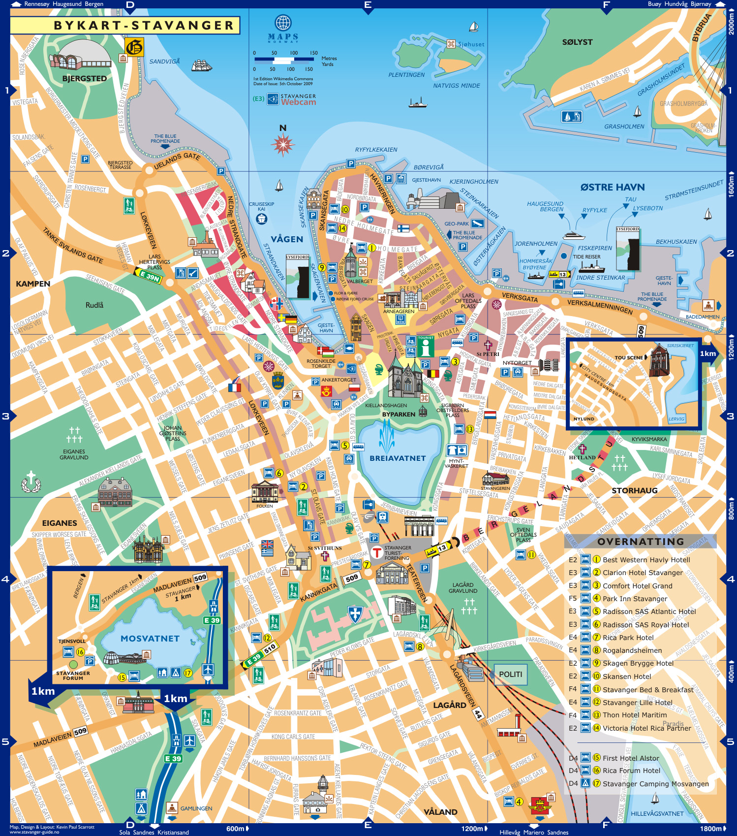
A city map is a large-scale thematic map of a city (or part of a city) created to enable the fastest possible orientation in an urban space. The graphic representation of objects on a city map is therefore usually greatly simplified, and reduced to generally understood symbology.
Depending upon its target group or market, a city map will include not only the city's transport network, but also other important information, such as city sights or public institutions.
The scale of a city map is usually between 1:10,000 and 1:25,000. Densely settled downtown areas will sometimes be partly drawn in a larger scale, on a separate detail map.
In addition to linear true to scale maps, there are also maps with variable scale, for example where the scale gradually increases towards the city centre (aerial photography, and photogrammetry methods).
Central to the information provided by a city map is the street network, including its street names (often supplemented by at least a selection of individual house numbers), along with buildings, parks and waterways. Streets and points of interest are usually also listed in a legend or register, locating objects on a map grid on the map. Important places such as administrative buildings, cultural institutions, attractions, etc. may be highlighted with the assistance of pictograms. The map may also be complemented by representations of public transport facilities.
As early as the time of the Ancient Near East, clay tablets were being produced with scaled, graphical representations of cities. Excavations of the Sumerian city of Nippur brought to light a fragment of an approximately 3,500-year-old city map, which is sometimes referred to as the oldest known city map. The clay tablet depicts the temple of Enlil, a city park, the city wall including its gates, along with a canal and the river Euphrates. The individual objects on this map were already labelled, in a Sumerian cuneiform.
In manuscripts and early printed books of the Late Middle Ages, cities are often shown in profile, or viewed from an elevated standpoint. Nautical charts of that time sometimes depict partly stylized cityscapes drawn in pictogram form - for example in Cristoforo Buondelmonti's Liber insularum archipelagi (Book of Islands), from the year 1422.
The Nuremberg Chronicle, which first appeared in 1493, is one of the most important collections of city views of the late Middle Ages, with over 100 such illustrations. Nevertheless, panoramas like this one, or the one in Bernhard von Breydenbach's Travelogue from 1483, had more narrative or representative functions.
Hub AI
City map AI simulator
(@City map_simulator)
City map
A city map is a large-scale thematic map of a city (or part of a city) created to enable the fastest possible orientation in an urban space. The graphic representation of objects on a city map is therefore usually greatly simplified, and reduced to generally understood symbology.
Depending upon its target group or market, a city map will include not only the city's transport network, but also other important information, such as city sights or public institutions.
The scale of a city map is usually between 1:10,000 and 1:25,000. Densely settled downtown areas will sometimes be partly drawn in a larger scale, on a separate detail map.
In addition to linear true to scale maps, there are also maps with variable scale, for example where the scale gradually increases towards the city centre (aerial photography, and photogrammetry methods).
Central to the information provided by a city map is the street network, including its street names (often supplemented by at least a selection of individual house numbers), along with buildings, parks and waterways. Streets and points of interest are usually also listed in a legend or register, locating objects on a map grid on the map. Important places such as administrative buildings, cultural institutions, attractions, etc. may be highlighted with the assistance of pictograms. The map may also be complemented by representations of public transport facilities.
As early as the time of the Ancient Near East, clay tablets were being produced with scaled, graphical representations of cities. Excavations of the Sumerian city of Nippur brought to light a fragment of an approximately 3,500-year-old city map, which is sometimes referred to as the oldest known city map. The clay tablet depicts the temple of Enlil, a city park, the city wall including its gates, along with a canal and the river Euphrates. The individual objects on this map were already labelled, in a Sumerian cuneiform.
In manuscripts and early printed books of the Late Middle Ages, cities are often shown in profile, or viewed from an elevated standpoint. Nautical charts of that time sometimes depict partly stylized cityscapes drawn in pictogram form - for example in Cristoforo Buondelmonti's Liber insularum archipelagi (Book of Islands), from the year 1422.
The Nuremberg Chronicle, which first appeared in 1493, is one of the most important collections of city views of the late Middle Ages, with over 100 such illustrations. Nevertheless, panoramas like this one, or the one in Bernhard von Breydenbach's Travelogue from 1483, had more narrative or representative functions.
Recent media