Recent from talks
Congo Pedicle
Knowledge base stats:
Talk channels stats:
Members stats:
Congo Pedicle
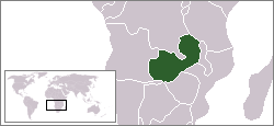
The Congo Pedicle (at one time referred to as the Zaire Pedicle; in French, la botte du Katanga, meaning 'Katanga boot') is the southeast salient of the Haut-Katanga Province of the Democratic Republic of the Congo, which divides neighbouring Zambia into two lobes. In area, the pedicle is similar in size to Wales or New Jersey. 'Pedicle' is used in the sense of 'a little foot'. 'Congo Pedicle' or 'the Pedicle' is also used to refer to the Congo Pedicle road, which crosses it.
The Congo Pedicle is an example of the boundaries imposed by European powers on Africa in the wake of the Scramble for Africa, which were set by European interests and usually did not consider pre-existing political or tribal boundaries.
As it is located at the country's southeastern extremity, its eastern end is closer to the capital cities of 17 other African countries than its own, Kinshasa.
Cecil Rhodes's British South Africa Company (BSAC) approached Katanga from the south, and the Belgian King Leopold II's Congo Free State (CFS) approached from the northwest. Southeast Katanga was controlled by the Yeke or Garanganze kingdom of Msiri based at Bunkeya (see map[which?]), and the BSAC and CFS competed to sign treaties with him while he tried to play one off against the other.
After Msiri's death the CFS was quicker to consolidate their claim to Msiri's territory called 'Garanganza', and later Katanga, west up to the Luapula. Since 1885 they already had claimed land north of the Congo-Zambezi watershed. The BSAC was left with the land south of the watershed and east of the Luapula. The 1884–85 Berlin Conference was organised by Germany to resolve the outcome of the Scramble for Africa. It did not set the actual boundaries, but agreed areas of influence, including the CFS's control over the Congo. Detailed borders were left to bilateral negotiations.
The main problem of both the Belgian and British sides over the southeast Katanga border was the lack of an obvious geographical feature for the border to follow, as the Congo-Zambezi watershed boundary and the Luapula do not meet. Separated by a distance of 70 to 150 km (43.50 to 93.21 mi), they run in an arc curving southeast then northeast, running almost parallel but gradually getting closer, and would reach the highlands between Lakes Tanganyika and Nyasa if the Chambeshi River, considered the ultimate source stream of the Congo River, were accepted as being the same river as the Luapula.
From the British point of view, the obvious choice for the border would have been southwest to northeast line from the watershed to the Luapula. Failing agreement on that, a second option would be to continue southwards the line of the Luapula-Lake Mweru valley (longitude 28° 35' E) which forms the longest north–south part of the border, until it intersects the Congo-Zambezi watershed, so all of the country immediately east of a north–south line through Ndola would then be in Northern Rhodesia. But the Belgians hoped for access to the rich game areas of the Bangweulu Wetlands and pressed for the borders to stick to the river and watershed. In negotiations for a treaty some 'trading' of territories was involved in northeast Congo, Sudan and Uganda. There was also the question of how far east into the Bangweulu swamps and floodplain the Pedicle should extend. The king of Italy[which?] was called in to adjudicate[when?], and he drew a north–south line (a line of longitude) through a point on the map where the Luapula was thought to exit from the Lake Bangweulu swamps[citation needed], which gave birth to the Pedicle: 70 to 100 km (43.50 to 62.14 mi) wide and about 200 kilometres (120 mi) long.
The agreement was incorporated into this larger treaty between Great Britain and King Leopold II, which dealt mainly with Equatoria.
Hub AI
Congo Pedicle AI simulator
(@Congo Pedicle_simulator)
Congo Pedicle
The Congo Pedicle (at one time referred to as the Zaire Pedicle; in French, la botte du Katanga, meaning 'Katanga boot') is the southeast salient of the Haut-Katanga Province of the Democratic Republic of the Congo, which divides neighbouring Zambia into two lobes. In area, the pedicle is similar in size to Wales or New Jersey. 'Pedicle' is used in the sense of 'a little foot'. 'Congo Pedicle' or 'the Pedicle' is also used to refer to the Congo Pedicle road, which crosses it.
The Congo Pedicle is an example of the boundaries imposed by European powers on Africa in the wake of the Scramble for Africa, which were set by European interests and usually did not consider pre-existing political or tribal boundaries.
As it is located at the country's southeastern extremity, its eastern end is closer to the capital cities of 17 other African countries than its own, Kinshasa.
Cecil Rhodes's British South Africa Company (BSAC) approached Katanga from the south, and the Belgian King Leopold II's Congo Free State (CFS) approached from the northwest. Southeast Katanga was controlled by the Yeke or Garanganze kingdom of Msiri based at Bunkeya (see map[which?]), and the BSAC and CFS competed to sign treaties with him while he tried to play one off against the other.
After Msiri's death the CFS was quicker to consolidate their claim to Msiri's territory called 'Garanganza', and later Katanga, west up to the Luapula. Since 1885 they already had claimed land north of the Congo-Zambezi watershed. The BSAC was left with the land south of the watershed and east of the Luapula. The 1884–85 Berlin Conference was organised by Germany to resolve the outcome of the Scramble for Africa. It did not set the actual boundaries, but agreed areas of influence, including the CFS's control over the Congo. Detailed borders were left to bilateral negotiations.
The main problem of both the Belgian and British sides over the southeast Katanga border was the lack of an obvious geographical feature for the border to follow, as the Congo-Zambezi watershed boundary and the Luapula do not meet. Separated by a distance of 70 to 150 km (43.50 to 93.21 mi), they run in an arc curving southeast then northeast, running almost parallel but gradually getting closer, and would reach the highlands between Lakes Tanganyika and Nyasa if the Chambeshi River, considered the ultimate source stream of the Congo River, were accepted as being the same river as the Luapula.
From the British point of view, the obvious choice for the border would have been southwest to northeast line from the watershed to the Luapula. Failing agreement on that, a second option would be to continue southwards the line of the Luapula-Lake Mweru valley (longitude 28° 35' E) which forms the longest north–south part of the border, until it intersects the Congo-Zambezi watershed, so all of the country immediately east of a north–south line through Ndola would then be in Northern Rhodesia. But the Belgians hoped for access to the rich game areas of the Bangweulu Wetlands and pressed for the borders to stick to the river and watershed. In negotiations for a treaty some 'trading' of territories was involved in northeast Congo, Sudan and Uganda. There was also the question of how far east into the Bangweulu swamps and floodplain the Pedicle should extend. The king of Italy[which?] was called in to adjudicate[when?], and he drew a north–south line (a line of longitude) through a point on the map where the Luapula was thought to exit from the Lake Bangweulu swamps[citation needed], which gave birth to the Pedicle: 70 to 100 km (43.50 to 62.14 mi) wide and about 200 kilometres (120 mi) long.
The agreement was incorporated into this larger treaty between Great Britain and King Leopold II, which dealt mainly with Equatoria.
Recent media