Hubbry Logo
Cyclone NumaCyclone NumaMain
Open search
Cyclone Numa
Community hub
Cyclone Numa
logo
8 pages, 0 posts
0 subscribers
Be the first to start a discussion here.
Cyclone Numa
Cyclone Numa
from Wikipedia
Cyclone Numa
Numa over the Ionian Sea on 18 November, after peak intensity
Meteorological history
Formed11 November 2017
Dissipated20 November 2017
Tropical storm
Highest winds100 km/h (65 mph)
Lowest pressure995 hPa (mbar); 29.38 inHg
Overall effects
Fatalities22[1]
Damage$100 million (2017 USD)
85 million (2017 Euro)
Areas affectedUnited Kingdom, Ireland, France, Italy, Tunisia, Greece, Turkey

Cyclone Numa, also known as Medicane Numa,[2] was a Mediterranean tropical-like cyclone with the properties of a subtropical cyclone.[2][3][4][5][6] Numa formed on 11 November 2017 west of the British Isles, out of the extratropical remnants of Tropical Storm Rina, the seventeenth named storm of the 2017 Atlantic hurricane season. Subsequently, on 17 November, Numa acquired subtropical characteristics[7] before reaching peak intensity on 18 November,[2][8] becoming a rare "medicane". After making landfall in Greece on 18 November, Numa rapidly weakened, and was later absorbed into another extratropical storm on 20 November.[9] The flooding triggered by Numa became the worst weather event Greece had experienced since 1977,[10] and the storm caused an estimated $100 million (2017 USD) in damages in Europe.[1]

The National Observatory of Athens named the system Zenon.[10][11]

Meteorological history

[edit]
Map plotting the storm's track and intensity, according to the Saffir–Simpson scale
Map key
  Tropical depression (≤38 mph, ≤62 km/h)
  Tropical storm (39–73 mph, 63–118 km/h)
  Category 1 (74–95 mph, 119–153 km/h)
  Category 2 (96–110 mph, 154–177 km/h)
  Category 3 (111–129 mph, 178–208 km/h)
  Category 4 (130–156 mph, 209–251 km/h)
  Category 5 (≥157 mph, ≥252 km/h)
  Unknown
Storm type
triangle Extratropical cyclone, remnant low, tropical disturbance, or monsoon depression

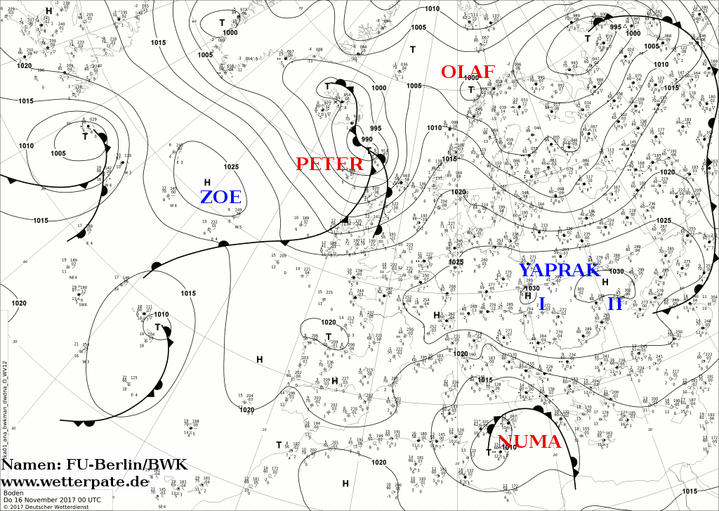
On 12 November, the Free University of Berlin named a low-pressure system over the British Isles Numa.[12] Moving southeastward, Numa quickly crossed the southern British Isles, and then France and Italy, before splitting into two low-pressure centres – Numa I and Numa II – on 13 November. Numa II was the stronger of the two, tracking down the centre of the Adriatic Sea, parallel to the Italian coastline and reaching an initial peak intensity of 995 hPa (29.4 inHg) on that day.[13] By 14 November, low-pressure centre Numa I had dissipated, and Numa II dominated the system, and the system was referred to simply as "Numa," while it was located in the open Mediterranean, to the west of Greece.[14]

Numa subsequently slowed and turned south, crossing southern Italy and emerging to the north of Sicily, before stalling over the island on 15 November.[15] Clearing Sicily to the southeast on 16 November,[16] Numa began to gain subtropical characteristics, while situated off the west coast of Greece, though by 16 November, the system was still extratropical.[16] Around this time, some computer models forecasted that Numa may soon transition into a warm-core subtropical or tropical cyclone, which would bring stronger winds and more flash flooding to Greece if this were to occur.[17]

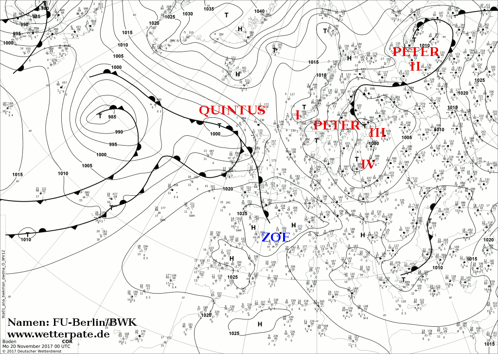
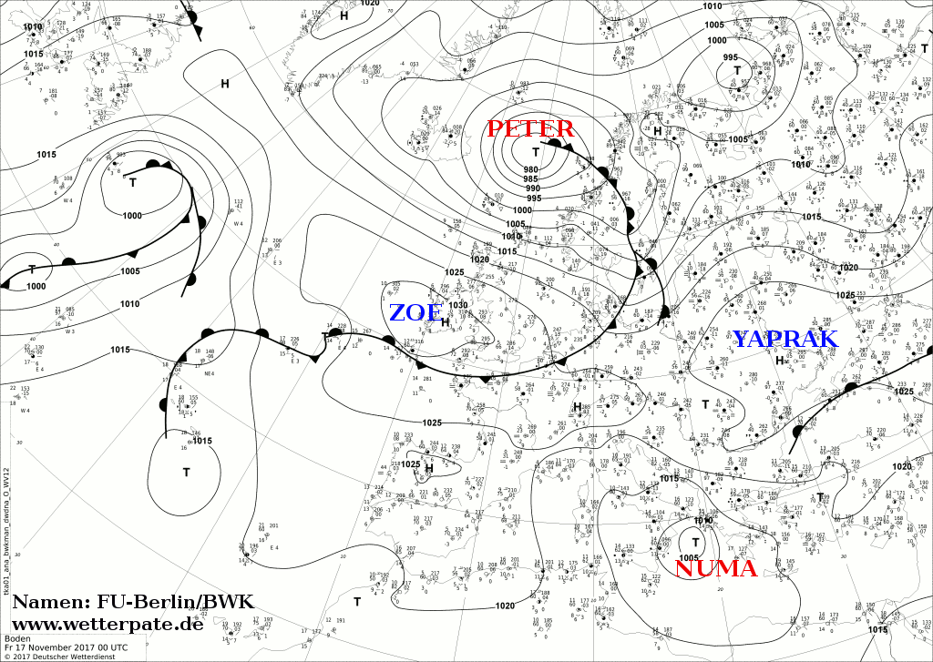
On 17 November, Numa stalled in the Ionian Sea and completely lost its frontal system.[18] On the afternoon of the same day, Météo France tweeted that Numa had attained the status of a subtropical Mediterranean depression.[19] According to ESTOFEX, Numa showed numerous 83-kilometre-per-hour (52 mph; 45 kn) flags of 10-minute sustained winds in satellite data.[20] During the next several hours, Numa continued to strengthen, before reaching its peak intensity on 18 November. Between 18:00 UTC on 17 November and 5:00 UTC on 18 November, Numa acquired evident tropical characteristics; between 22:00 UTC on 17 November and 01:00 UTC on 18 November, Numa began to display a hurricane-like structure;[2] ESTOFEX still reported 10-minute sustained winds of 83 km/h (52 mph; 45 kn) at about this time. Around the time of Numa's peak, the storm had a clear, well-defined eye structure,[8] with the National Oceanic and Atmospheric Administration noting an eyewall similar to that of a hurricane's.[7] Satellite ASCAT indicated that the storm had 1-minute sustained winds of 102 km/h (63 mph; 55 kn), equivalent to tropical storm intensity,[21][22] though the actual winds may have been higher, due to the small diameter of the storm. Later on the same day, Numa made landfall in Greece, producing a storm surge at the Gulf of Patras and damaging wind gusts, before rapidly weakening into a low-pressure area afterward. Subsequently, the system emerged into the Aegean Sea on 19 November.[23] On 20 November, Numa was absorbed into another extratropical storm approaching from the north.[9]

Impact

[edit]

Prior to Numa's arrival, unusually heavy rainfall from other storm systems had been affecting mainland Greece for around a week, leading to some localised flooding. The fire brigade had received over 600 calls relating to flooding in the days preceding Numa's arrival, dispatching more than 200 firefighters in 55 vehicles to villages across the country to assist.[24]

Numa was linked to exceptionally heavy rainfall across the Balkans in mid-November, which lasted for over week, killing at least 21 people in Greece, with Athens being the worst affected area.[25][5][6][10] However, the National Observatory of Athens did not link the flooding to Numa, naming an earlier low which had initiated the flooding Eurydice.[26]

The flooding associated with Numa became the deadliest weather event that Greece has experienced since 1977.[10][7]

Numa began to bring heavy rainfall to already saturated areas of the Balkans beginning on 15 November, causing severe flooding, especially in central mainland Greece. By 16 November, at least 16 people had been killed by flooding in the towns of Mandra, Megara, and Nea Peramos to the west of Athens, with five people missing.[27] Many of those who were killed were elderly residents unable to escape their homes, as floodwaters quickly rose.[24] On 19 November, the death toll in Greece increased to 19, while 3 people still remained missing.[10] On 21 November, the death toll increased to 21, with 1 man still missing.[26]

At least 86 people were rescued[25] and at least 37 people were hospitalised across Greece, and more than one third of buildings were destroyed in the town of Nea Peramos, including over 1,000 homes.[24] Thousands of homes were left without electricity or running water after being inundated by more than a metre of floodwater, with the national electricity grid suffering severe damage.[25] More than 20 schools remained closed on 17 November, with further flooding anticipated, while Numa stalled off the Greek coast.[25]

In the aftermath of the flooding, Greek Prime Minister Alexis Tsipras declared three days of national mourning and a state of emergency,[25] saying it was "the least we can do". Food, water and blankets were distributed to victims in the worst affected towns.[27] The deputy governor of the worst-affected West Attica region, Yiannis Vassileiou, likened the flooding to Niagara Falls, while mayor of Mandra Yianna Krikouki referred to the flooding as "biblical", with the flooding leaving "nothing standing" in the town.[24][25] European Commission President Jean-Claude Juncker, French President Emmanuel Macron, and Turkish Deputy Prime Minister Hakan Çavuşoğlu expressed their condolences to the people of Greece, following the tragedy.[25][28] A 364-cabin cruise ship was later opened up as a shelter for those made homeless by the disaster.[27]

See also

[edit]

References

[edit]

Further reading

[edit]
[edit]
Revisions and contributorsEdit on WikipediaRead on Wikipedia
from Grokipedia
Cyclone Numa was a rare , also known as a medicane, that developed in the central in mid-November 2017. The system originated from the remnants of Atlantic Tropical Storm Rina and tracked across before acquiring subtropical and tropical characteristics over the south of , bringing severe weather to and surrounding areas. In its earlier extratropical phase, the cyclone caused deadly flash flooding in eastern , resulting in at least 20 deaths, while its later medicane phase produced heavy rains and flooding in . By November 18, Numa intensified into a hybrid storm with a well-defined eye-like feature visible on , exhibiting sustained winds of around 60 mph (95 km/h) and a minimum central pressure of 994 hPa. Numa tracked slowly eastward, looping near before making landfall near the Greek island of Kefalonia on November 18, after which it weakened rapidly over land and dissipated by November 19. The produced extreme rainfall totals of 100–300 mm (4–12 inches) in and , triggering flash floods, landslides, and widespread infrastructure damage. Named by the Free University of Berlin's Institute of , Numa represented one of the few documented medicanes in recent decades, highlighting the Mediterranean's vulnerability to such hybrid storms amid warming sea temperatures that may favor their formation. These events, occurring roughly once or twice per year, combine extratropical and tropical features but are limited by the 's cooler temperatures and shallower depths compared to the Atlantic or Pacific. The associated flooding in marked the deadliest weather disaster since 1977.

Background

Naming and classification

Cyclone Numa was named on 12 November 2017 by the Free University of Berlin's Institute of Meteorology, which maintains a for low-pressure systems affecting as part of its "Adopt a Vortex" program. The system originated from the remnants of Atlantic Tropical Storm Rina. Numa was classified as a medicane, a portmanteau of "Mediterranean" and "hurricane," referring to rare tropical-like cyclones that form over the . Medicanes exhibit hybrid subtropical-tropical properties, characterized by a warm core, convective spiral rainbands, and sometimes an eye-like feature, distinguishing them from typical extratropical cyclones that rely on baroclinic instability and possess a cold core. These systems typically measure 100-200 km in diameter and develop over warm sea surface temperatures exceeding 20°C, enabling convection-driven intensification akin to tropical cyclones but on a smaller scale due to the enclosed basin's constraints. By 17 2017, Numa had acquired subtropical characteristics, including a warm core and an emerging eye-like structure, solidifying its medicane classification despite its extratropical origins. The term "medicane" emerged in the late with advances in satellite observation, highlighting these storms' hurricane-like traits. A study documented 99 medicanes from 1948 to 2011, occurring at an average rate of about 1.6 per year, primarily in autumn.

Origins from Tropical Storm Rina

Tropical Storm Rina formed in the central Atlantic Ocean on November 5, 2017, as a tropical depression approximately 700 nautical miles east-southeast of Bermuda, strengthening to tropical storm status by November 7 while located about 780 nautical miles east of Bermuda. The system tracked slowly eastward initially, then accelerated northward, reaching peak intensity on November 8 with maximum sustained winds of 50 knots (58 mph) about 650 nautical miles south-southeast of Cape Race, Newfoundland. Rina transitioned into a post-tropical cyclone by 0600 UTC on November 9, located roughly 300 nautical miles southeast of Cape Race, and fully dissipated later that day after merging with an extratropical low-pressure area over the northern Atlantic. The remnants of Rina, carrying residual tropical moisture and , were drawn northeastward by the prevailing mid-latitude flow, approaching the by late November 10 and early November 11. This interaction with a mid-latitude trough over the North Atlantic facilitated the development of a new extratropical late on November 11, positioned west of the , as the remnant energy merged with the frontal zone of the larger synoptic system. The influx of Rina's moisture contributed to enhanced instability in the developing low, though it remained broadly structured without closed isobars at this nascent stage. A key synoptic feature was a persistent blocking high-pressure over , which deflected the remnants southeastward rather than allowing typical eastward progression across the North Atlantic, while an anticyclone near the further channeled the flow. This setup, combined with a cold air outbreak from the North Atlantic toward on November 11-12, provided the environmental conditions for the low's initial . Early from Meteosat on November 11 revealed disorganized scattered around the low's center, with patterns indicative of baroclinic activity and no evidence of structure, such as a warm core or symmetric . These characteristics marked the as a potential precursor to a medicane, though it exhibited predominantly extratropical features initially.

Meteorological history

Initial development over the Atlantic

Cyclone Numa originated from the extratropical remnants of Tropical Storm Rina, which had transitioned into a post-tropical cyclone over the northern Atlantic Ocean on November 9, 2017, after merging with a complex extratropical low-pressure area. By November 11, these remnants contributed to the formation of a new low-pressure system west of the British Isles, initially exhibiting extratropical characteristics due to interaction with cold air masses advected from an upper-level trough. This interaction enhanced baroclinicity, promoting the system's early organization as it drifted southeastward across the Atlantic, with moderate vertical wind shear limiting immediate convective development. Numerical weather prediction models, including the ECMWF , forecasted the system's southeastward trajectory toward the Mediterranean but tended to underestimate the moisture content carried over from Rina's remnants, which later influenced its evolution. Satellite observations during this phase revealed a multi-banded structure indicative of an asymmetric, disorganized circulation, lacking a distinct warm core at the surface and upper levels, consistent with its extratropical nature.

Path across northwestern Europe

After transitioning to an on 9 southeast of Newfoundland, the remnants of Tropical Storm Rina accelerated northeastward across the North Atlantic, steered by strong mid-latitude westerly flow between a to the east and a deepening trough to the west. By 10 , the system approached the from the southwest, crossing and the in a southeastward trajectory over the next 24 hours, with its center passing near 53°N, 8°W early on 11 . This phase featured gale-force winds up to 65 km/h (40 mph) and widespread rain bands, influenced by interactions with a deep upper-level trough extending from southward. The cyclone continued southeastward across on 11–12 November, entering the Mediterranean via the near 43°N, 4°E, before tracking toward . Land friction over the densely populated regions of caused significant weakening, with sustained winds decreasing from gale-force levels during the crossing of the and around 13 November. Central pressure stabilized around 1000 hPa during this transit, with minor fluctuations driven by enhanced baroclinicity from the advection of continental cold air masses interacting with warmer maritime air. Over the period from to 14, the low-pressure center gradually intensified, reaching a central pressure of approximately 1002 hPa and sustained surface winds of up to 19 m/s (about 68 km/h) within a 300 km radius by November 14. ECMWF reanalysis data from the ERA5 dataset illustrate the system's integration into broader European synoptic patterns, including a that facilitated the development of asymmetric rain bands extending from the Biscay Bay toward the , contributing to totals exceeding 50 mm in parts of and . By 15 November, the low had reached the off western near 40°N, 12°E, where it stalled briefly southeast of due to blocking by a persistent anticyclone over , setting the stage for subsequent reorganization.

Intensification in the Mediterranean

After crossing as a weakening , Numa stalled over the central Mediterranean and began re-intensifying on , 2017, as it drifted into the between and . The system transitioned to subtropical status by 0000 UTC on , with convection surrounding the center and cloud tops cooling to -50 to -55°C, supported by sea surface temperatures around 21°C that facilitated surface heat and moisture fluxes. Low vertical , estimated below 10 m/s up to 6 km altitude, allowed for organized development, while moderate upper-level enhanced by a nearby contributed to the removal of mass aloft, promoting further deepening. By 1200 UTC on November 17, Numa had strengthened into a tropical storm, exhibiting weak upper-level outflow and intensified after sunset, leading to a more symmetric structure with spiral bands. observations from EUMETSAT's Meteosat-9 revealed a whirl of convective destabilized by the cold, humid airmass over the warm Ionian waters, with initial weak shear enabling the buildup of deep . A warm core became evident in thickness and maps at 850 hPa, peaking with a of about 3°C at 700 hPa and extending vertically from roughly 1 to 8 km altitude. release from this drove the 's hybrid tropical-extratropical traits, as confirmed by the Hart phase space diagram using a 70 km , indicating a shift toward tropical characteristics. Numa reached its peak intensity around 0000 UTC on , with maximum sustained winds of 95 km/h (59 mph) in a well-defined eyewall and a central pressure of 994 hPa, marking its full transition to medicane status. satellite imagery from /Sat24 showed cloud tops as cold as -60 to -65°C surrounding an almost fully closed eye-like feature approximately 75 km in diameter, while Suomi NPP VIIRS data captured the symmetric structure and eyewall as the storm moved eastward in the . Satellite-derived intensity estimates, including pattern analysis akin to the , classified the system as subtropical to tropical-like at this stage, with a strong of about 5 hPa per 50 km underscoring its compact, intense nature. The combination of favorable environmental conditions, including the 20-24°C sea surface temperatures in the , sustained the and symmetric development until shear began to increase later that day.

Landfall in Greece and dissipation

As Cyclone Numa approached the western coast of after reaching peak intensity in the , it made near Kefalonia Island around 2300 UTC on 18 November 2017, with sustained winds of approximately 75 km/h (47 mph) and a central pressure of 998 hPa. The interaction with the rugged Greek terrain triggered , which disrupted the cyclone's symmetric structure and resulted in an asymmetric rainfall distribution, concentrating heavier precipitation in the southern sectors over elevated areas. Following , Numa rapidly weakened over land, dropping to tropical depression strength by 0600 UTC on 19 November, with sustained winds decreasing to about 65 km/h (40 mph) and central pressure rising to 1002 hPa. The system's diminished due to and entrainment of cooler continental air, leading to a loss of organization by late morning on 19 November when it transitioned into a remnant low. Numa fully dissipated by 0000 UTC on 20 November 2017, as its remnants merged with a larger extratropical low moving across . Post-event analysis by the Cooperative Institute for Meteorological Satellite Studies (CIMSS) classified the as a hybrid subtropical system, confirming its decay was accelerated by cool and land-induced shear.

Impacts

Effects in the and

Cyclone Numa formed on 11 November 2017 west of the from the extratropical remnants of Tropical Storm Rina. The system crossed the and on 12 November, bringing gusty winds and rain, but no significant disruptions, damages, or fatalities were reported.

Impacts in France and Italy

As the extratropical precursor to the medicane phase crossed and entered on 13–14 November 2017, it brought heavy rainfall to these regions. Rainfall accumulations of 100–300 mm fell over over several days, contributing to localized flooding and thunderstorms. In , precipitation exacerbated runoff in coastal areas. Gusty winds of 50–70 km/h affected Mediterranean ports, leading to some ferry cancellations. issued yellow alerts for and strong winds in the region. No major infrastructure damage or injuries were reported, though the rains impacted agriculture in Italy.

Devastation in Greece

Cyclone Numa brought torrential rains to the Attica region of Greece, dumping 200–300 mm of precipitation in just 48 hours in areas such as Mandra, Megara, and Nea Peramos, marking the heaviest downpours since the deadly floods of 1977. These intense rains triggered catastrophic flash floods and mudslides, transforming dry riverbeds into raging torrents that swept through low-lying suburbs west of Athens. The flooding was exacerbated by the cyclone's landfall on November 18, with peak winds reaching 60 mph, though the primary devastation stemmed from the prolonged deluge rather than wind damage. The human toll was severe, with at least 20 people killed across the affected areas, including eight fatalities in Mandra alone where floodwaters overwhelmed homes and vehicles. Among the tragic incidents, a family of four drowned in a sudden torrent in Mandra, their home buried under a wall of mud and debris. Rescue operations saved 86 individuals via helicopter and boat extractions, while 37 others were hospitalized for injuries ranging from to trauma from collapsing structures. The victims, mostly aged 45–70, highlighted the vulnerability of elderly residents in flood-prone zones without adequate evacuation warnings. Infrastructure suffered widespread destruction, with over 1,000 homes and businesses inundated or completely demolished by mudslides that buried cars and blocked roads. Key roadways and railway lines in the suburbs were washed out, isolating communities and complicating relief efforts, while power outages affected approximately 61,000 households due to flooded substations. In Nea Peramos, coastal surges compounded the inland flooding, leading to flows that damaged local bridges and agricultural lands. The total economic impact in was estimated at $100 million, encompassing repairs to housing, transportation networks, and lost productivity in the capital's outskirts. In response, the declared a on November 15, mobilizing national resources for immediate aid and allocating emergency funds for affected families. This event underscored the growing risks of medicanes in intensifying hazards in urbanized Mediterranean regions.

Aftermath and significance

Immediate response and recovery efforts

In the immediate aftermath of Cyclone Numa's landfall, the Greek government mobilized emergency services, including the fire brigade and civil protection units, to conduct search and rescue operations, clear debris, and restore essential services in the hardest-hit areas of western Attica, such as Mandra, Megara, and Nea Peramos. The Hellenic Red Cross (HRC) responded swiftly at the request of civil protection authorities, deploying Samaritan volunteers for 24/7 patrols, first aid, body recovery, water pumping from flooded homes, and distribution of food, water, and hygiene kits to affected residents. By mid-December 2017, the government had allocated emergency compensation of €5,000 per damaged household and €8,000 per affected business, benefiting hundreds of families and enterprises amid assessments revealing 428 damaged structures, including 319 homes. International support complemented national efforts, with the Attica regional authority announcing plans to apply for funding from the Solidarity Fund to aid reconstruction and infrastructure repair. The International Federation of the Red Cross and Red Crescent Societies (IFRC) provided logistical and financial backing to the HRC operation, enabling the distribution of relief goods and cash assistance to vulnerable households, while support teams assisted survivors, including housing around 40 individuals in temporary accommodations. Short-term recovery initiatives laid groundwork for longer-term resilience, including the deployment of civil engineers by the Ministry of Infrastructure to survey and repair systems, which had been disrupted for thousands in the affected towns. Following the disaster, Greek authorities initiated improvements to warning systems, particularly in peri-urban basins like Mandra, incorporating advanced nowcasting tools to enhance real-time monitoring and alerts for future events. These measures addressed vulnerabilities exposed by the storm, which claimed 20 lives in . Recovery faced significant challenges, including initial shortages of potable and , as well as incidents of in evacuated zones, which strained response coordination. Political debates intensified over failures, particularly the role of in flood-prone areas that exacerbated inundation and left hundreds homeless, prompting calls for stricter enforcement of building regulations in western .

Climatological context and records

Cyclone Numa was one of the rare intense medicanes observed in the Mediterranean since 1990, underscoring their infrequency compared to the overall average of 1.5 medicanes per year over the past six decades. The development of intense medicanes like Numa is facilitated by elevated sea surface temperatures (SSTs) in the Mediterranean, which have risen by approximately 2°C since the early 1980s, primarily attributed to anthropogenic . This warming enhances atmospheric moisture availability, contributing to the convective intensity of these systems. Numa established several precipitation records during its passage, including the highest short-duration rainfall in since observations began in the , with up to 300 mm recorded in just 8 hours near Mandra on 15 November 2017. Furthermore, it marked the first medicane for which the (GPM) Core Observatory's Dual-frequency Precipitation Radar (DPR) provided detailed overpasses, capturing the vertical structure of its precipitation and revealing warm rain processes dominant in its mature phase. These observations offered unprecedented insights into the storm's hybrid subtropical-tropical characteristics, with weaker and asymmetric rainfall distribution compared to fully tropical cyclones. In comparison to Medicane Ianos of September 2020, Numa exhibited similar peak intensity, with central pressures around 990 hPa, but resulted in greater loss of life—20 fatalities in —due to its landfall near densely populated urban areas around . IPCC assessments project a potential decrease in overall medicane frequency under future scenarios, yet an increase in the intensity of the most severe events, driven by continued SST rises and atmospheric destabilization. A 2019 study highlighted ongoing research gaps in Numa's hybrid dynamics, utilizing GPM microwave and radar data to refine estimates and model validations for such systems. The event's total damages exceeded $100 million, emphasizing its socioeconomic impact. Long-term recovery efforts, supported by funding, focused on upgrades, with studies as of 2023 confirming heightened medicane risks due to warming trends.

References

Add your contribution
Related Hubs
User Avatar
No comments yet.