Hubbry Logo
DaillyDaillyMain
Open search
Dailly
Community hub
Dailly
logo
8 pages, 0 posts
0 subscribers
Be the first to start a discussion here.
Dailly
Dailly
from Wikipedia

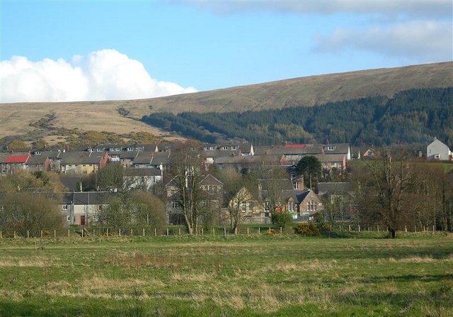
Dailly (Scottish Gaelic: Dail Mhaol Chiarain)[2] is a village in South Ayrshire, Scotland. It is located on the Water of Girvan, five miles (eight kilometres) south of Maybole, and three miles (five kilometres) east of Old Dailly. "New Dailly", as it was originally known, was laid out in the 1760s as a coal-mining village. In 1849 a fire broke out in Maxwell Colliery, one of the nearby mines, and continued to burn for 50 years. In Dailly there are two castles which the locals call the new castle and the old castle; they are both derelict.

Key Information

Notable people

[edit]

References

[edit]
[edit]
Revisions and contributorsEdit on WikipediaRead on Wikipedia
from Grokipedia
Dailly is a picturesque village in , , situated on the Water of Girvan approximately five miles south of Maybole and three miles north of , encompassing both the planned "New Dailly" developed in the 1760s and the nearby "Old Dailly" settlement. The name Dailly derives from Gaelic words meaning "meadow" and "field," reflecting the surrounding farmland and rolling hills that characterize the rural landscape. Known for its rich history dating back to , the village features notable landmarks such as the ruins of the original by the river and the later Adams Castle built in the by the , who played a significant role in its development. Today, Dailly serves as a vibrant hub with essential amenities including a church, shops, a , and a sports center, while offering outdoor enthusiasts access to a network of five scenic paths that highlight local history, nature, and woodlands. The village's strong and proximity to the west coast make it an inviting destination for those seeking authentic rural Scottish charm and hospitality.

Geography

Location and Setting

Dailly is a village located in , , situated along the banks of the Water of . The village's precise geographical coordinates are 55°16′36″N 4°43′28″W, corresponding to the Ordnance Survey grid reference NS270014. It lies within the administrative boundaries of the council area, which governs local services and planning in the region. Positioned 5 miles (8 km) south of Maybole and 3 miles (5 km) east of Old Dailly, Dailly serves as a central point in the rural landscape of Carrick, the encompassing much of . The village uses the postcode district KA26, with designated as the post town, and its telephone dialling code is 01465, shared with nearby communities along the coast. The Scottish Gaelic name for Dailly is Dail Mhaol Chiarain, derived from Gaelic terms meaning "meadow" and "field," reflecting its pastoral setting amid surrounding farmland and gentle hills.

Physical Features

Dailly is situated within the lower section of the Water of valley, a broad undulating dale characterized by gently rolling terrain and enclosed pastures that dominate the surrounding landscape. The river, originating from Loch Girvan Eye and flowing westward to the , shapes the area's hydrology, with its floodplain supporting lush meadows and riparian woodlands along the banks. This setting, typical of South Ayrshire's lowland river systems, features small to medium-sized fields bounded by intact hedgerows and shelterbelts, fostering a environment conducive to . The rolling countryside around Dailly exemplifies Ayrshire's agricultural lowlands, with meadows and fields that reflect the village's Gaelic-derived name, meaning "meadow and field," highlighting the area's historical emphasis on fertile dales and lands. Valley sides rise gradually to form smoother hills in the north and steeper, more rugged slopes to the south, creating a contained yet visually diverse topography with elevations in the village ranging from approximately 40 to 100 meters above . Surrounding farmland extends across these undulating slopes, interspersed with semi-natural woodlands of , sycamore, and that enhance the intimate scale of the landscape. While Dailly maintains an inland position about 7 miles from the coast, its connection to coastal areas occurs via the nearby town of at the river's mouth, though the local environment remains focused on valley-based features. Wooded policies and coniferous plantations dot the upper slopes, contributing to with habitats for wildlife such as and red squirrels. The Dailly Paths network traverses this terrain, offering access to riverside woods, glens like Falfarocher with waterfalls, and hilltops providing elevated views over the dale, underscoring the area's suitability for recreational walking amid its natural contours.

History

Origins and Early Settlement

The name Dailly derives from the Gaelic "Dail Mhaol Chiarain," referring to the meadow or dale associated with a devotee of St. Ciarán (also known as St. Kieran), an early Christian missionary whose influence reached the region through the . Early records refer to the area as Dalmakeran or Dalmaolkeran, meaning "the dale of St. Kieran," with the first documented mention appearing in 1404. By 1490, the name had shortened to Dailly, reflecting its location in a fertile valley along the Water of in the Carrick district of the former Kingdom of . The parish's pre-industrial foundations trace back to Celtic settlement patterns, evolving into an agricultural community under feudal lords by the medieval period. From the 15th century, the lands around Dailly were held by branches of the , prominent feudal lords in who controlled estates including the nearby , with ruins dating to at least the early 1400s. The Kennedys' influence is evident in medieval charters and land grants, tying the area to broader Scottish nobility following the establishment of the around 1186. Old Dailly served as the original settlement site, centered on a medieval church founded circa 1186 by Duncan, the first , and dedicated to St. Michael as Ecclesia Sancti Michaelis de Dalmulkerane. This church, initially granted to and later to Crossraguel Abbey under confirmations by and Robert III, functioned as the parish seat until around 1696, with its ruins preserving pre-Reformation architecture. The graveyard at Old Dailly Church holds significant historical remnants, including the graves of Covenanter martyrs John Semple and Thomas McClorgan, who were shot by government forces in 1685 for their adherence to Presbyterian principles during the "Killing Times." Semple, a local resident of Eldington on Hadyard Hill, was killed while sheltering fugitives, and both men are commemorated by an obelisk erected in 1825 within a railed enclosure southwest of the church ruins. Nearby, the Blue Stones—two large, smooth blue-grey boulders embedded in the church walls—functioned historically as charter stones, symbolizing land grants and community rights from ancient times, with Dailly occasionally called the "Blue Stone Burgh." These stones, weighing approximately 260-320 pounds each, were also used for strength tests by lifting them to prove physical prowess and for oaths, where touching them was believed to invoke sanctity or good fortune; in 1695, they became central to a dispute over the parish's relocation, ultimately remaining at Old Dailly.

Industrial Development

Dailly's industrial development in the 18th and 19th centuries centered on , transforming the area from rural lands held by the into a planned . In the , "New Dailly" was established as a dedicated coal-mining village, with streets laid out parallel to the Water of to house workers near the medieval-era pits. This planned expansion supported the extraction of from the rich seams of the Carrick coalfield, fostering and economic reliance on activities. Key to this growth was the development of collieries such as Maxwell Colliery, which targeted seams like the Main, Craigie, and others within the of the Late Carboniferous strata. Mining operations employed hundreds in hazardous conditions, contributing to the village's identity as a hub until the closure of the last colliery in 1977. However, safety challenges were evident in major incidents, including a devastating that ignited in Maxwell Colliery in and smoldered underground for about 50 years, until roughly 1900; this prolonged blaze disrupted production, heightened risks for workers, and strained the local economy by limiting access to workings. The industrial era also left a legacy in the derelict castles tied to estate owners overseeing the lands. The ruins of the original 15th-century , a Kennedy stronghold, stand as remnants of pre-industrial control, while the later "new castle"—a neoclassical mansion designed by and completed in 1790 for Thomas Kennedy of Dunure—overlooks the mining valley and reflects the wealth generated from estate resources, including . Both structures, now in ruinous states, symbolize the transition from feudal holdings to industrial exploitation in the region.

Demographics and Society

Dailly's population has undergone significant changes since the , reflecting its evolution from a small to a and back to a quiet village. In the late 1700s, the parish of Dailly, which encompasses the village, supported a modest , estimated at around 1,500 residents amid agricultural and early industrial activities. By the early , as expanded in the area, the population grew noticeably, peaking during the mining era before beginning a long-term decline associated with the industry's contraction. The following table summarizes key historical population figures for Dailly from data:
YearPopulation
18011,621
18111,756
18212,161
18312,074
18911,809
19011,673
2001908
2011895
These figures illustrate growth from 1801 to 1821, coinciding with heightened operations, followed by a steady decrease into the as collieries closed and residents migrated elsewhere, a trend that continued into the 21st century with 908 residents in 2001 and 895 in 2011. According to the 2022 census, the of the Dailly settlement was 833, representing a continuation of the post-industrial decline, with the village now exhibiting low typical of rural , where the broader council area spans approximately 1,222 square kilometers and supported about 111,500 people as of the 2022 census. Demographically, Dailly mirrors the aging profile common in Scottish rural villages, with featuring a higher-than-average proportion of residents over 65—26.5% as of the 2022 census—driven by longer life expectancies and out-migration of younger generations. This composition underscores the challenges and community dynamics of small, aging locales in the region.

Community Life

Dailly is a small rural in , , characterized by its welcoming atmosphere and emphasis on local history and hospitality, as promoted through the village's community website. The Dailly Parish Church serves as a central hub for social and spiritual life, offering worship services on the first, third, and fifth Sundays of each month and maintaining a rich history dating back to 1695, with the current building constructed in 1766. Community events foster connections among residents, including the annual Village Fete, a free Lunch, and gatherings at the Dailly Community Hall, which hosts activities such as the Monday Club's Cozy Space for adults and youth clubs for ages 12-18 in partnership with local trusts. The Dailly Community Trust coordinates these initiatives, along with practical support like a weekly Food Pantry to address food insecurity and IT drop-in sessions to build digital skills. Education in Dailly centers on the , located in the heart of the village on and serving children aged 2 to 12 from the surrounding rural area. The school emphasizes high-quality learning in a nurturing environment, encouraging pupil participation, confidence-building, and community involvement through events like Harvest and services at the , as well as collaborations with parents via open days and assemblies. For , pupils typically transition to Girvan Academy in nearby or Carrick Academy in Maybole, ensuring continuity in the broader educational network. The social fabric of Dailly reflects its rural charm, with many families maintaining ties to amid the rolling hills and lush greenery that define the . Volunteer groups, including the Dailly Community Trust and , play a vital role in sustaining community spirit through hands-on involvement in environmental projects, play-park improvements, and initiatives. This local engagement integrates seamlessly with the wider culture, sharing traditions of hospitality and resilience in a post-industrial context where farming and community support remain cornerstones of daily life. Contemporary Dailly faces challenges common to rural Scotland's post-industrial villages, particularly in maintaining its small amid declining numbers in remote areas due to limited services and economic shifts away from historical industries like . Efforts by the Community Trust and local partnerships aim to counter these pressures through inclusive programs that promote retention and vitality.

Economy and Infrastructure

Historical Economy

Prior to the industrial era, Dailly's economy was predominantly agrarian, centered on small-scale farming and feudal estate management under the influential , who held sway over much of Carrick since the . The Kennedys controlled key estates such as Bargany and Drummellan, where tenants engaged in cultivating crops on cleared woodlands and managing meadows for , supporting a subsistence-based system of arable and pastoral agriculture. This feudal structure emphasized pasturage over intensive cropping, with local farmers raising cattle and sheep on the parish's hilly terrain, yielding modest incomes from livestock sales and wool production—best improved pastures produced around 70 stone of wool annually at 11 shillings per stone in the late 18th century. From the onward, Dailly's economy shifted decisively toward as the dominant industry within the Carrick coalfield, building on earlier extractions dating back to 1415 under Crossraguel Abbey's . By the , operations at pits like Drummochreen (active since 1617) and Dalquharran (from 1701) expanded significantly, employing the majority of residents in extraction and related labor, with over 100 mines operating across the area during the peak period. This transition transformed Dailly from an agricultural into a mining-dependent , as fueled regional industries and exports, supplanting traditional farming as the of livelihood. A major setback occurred on 6 December 1849, when a erupted in the Dalquharran Colliery's Burning Pit, one of Dailly's key operations, reaching depths of 200 feet and burning underground for years, leading to the pit's permanent closure. The caused significant economic disruption, including widespread job losses for miners and their families who comprised much of the local workforce, exacerbating in an already specialized economy. Long-term environmental effects persisted, with visible red-hot hills and scorched land rendering surrounding areas unusable for or further for decades. Supplementary historical trades included limited quarrying of and , which supported through lime production as —and estate-related work on Kennedy holdings, such as maintenance and artisanal tasks at sites like Drummochreen. These activities provided ancillary employment but remained secondary to the agrarian and later sectors.

Modern Economy and Services

Following the decline of in the late , with the closure of the Dalquharran mine in 1977 marking the end of significant local extraction activities, Dailly's economy transitioned toward agriculture and small-scale as primary sectors. , a hallmark of South 's fertile landscape, dominates agricultural output in the area, alongside crop production on surrounding farmlands that support both local consumption and regional markets. Small-scale has emerged as a complementary mainstay, bolstered by Dailly's inclusion in the and Southern , which promotes sustainable rural economic activities through eco-friendly visitor experiences. Local services in Dailly center on essential amenities, including the Dailly Store and , which provides groceries, mail, and parcel services to residents. Traditional pubs and nearby establishments serve as social hubs for the community. For larger retail needs, residents rely on nearby , approximately 3 miles (5 km) south, where supermarkets and specialty shops are accessible. Transportation infrastructure supports connectivity without a local railway station, which closed in 1965. Bus services, including Stagecoach routes 358 and 360, provide regular links to Maybole and Girvan, facilitating commutes and access to broader amenities. The village benefits from proximity to the A77 trunk road, enabling efficient road travel to major centers like Ayr and Glasgow. Modern infrastructure includes reliable utilities such as water, electricity, and waste management provided by South Ayrshire Council and regional suppliers, ensuring standard rural service levels. Broadband access has improved significantly, with ultrafast fiber options available to many premises, enabling remote work and digital connectivity in this rural setting.

Landmarks and Culture

Historic Sites

Dailly is home to several notable historic sites that reflect its medieval and early modern heritage, particularly tied to the and religious in . These include ruined castles, a medieval church, and ancient stones, each offering insights into the area's feudal past and cultural traditions. The Old , a 15th-century ruin situated on the north bank of the Water of , dates back to at least the 13th century as an estate held by Crossraguel Abbey in an area dominated by the , known as the "Kings of Carrick." This L-plan , once a of a Kennedy branch, features typical defensive architecture of the period, including thick walls and a vaulted , though it fell into disuse by the late 18th century. The Kennedy family's long association with the site underscores their influence in Carrick's feudal landscape, as detailed in the area's early settlement . Nearby, the New Dalquharran Castle, designed by renowned architect and completed around 1790, replaced the older structure as a neoclassical mansion for Thomas Kennedy of Dunure. This category A , extended in the early 1880s, exemplifies Adam's castle-style architecture with its three-story design, round tower, and central stair, reminiscent of his work at . Abandoned in the after a fire in 1967, it now stands as dramatic ruins dominating the Dailly village skyline, with its masonry shell preserved amid the 261-acre estate. In September 2025, plans were submitted to Council for a £12 million holiday park with nearly 100 lodges on the estate, with approval anticipated by the end of 2025. The Old Dailly Church, a roofless structure of medieval origin, with the surviving ruins primarily dating to the , served as the until the and now functions primarily as a historic graveyard. Its simple rectangular layout with remnants of a and highlights early architecture in southwest . The site holds particular significance for its graves of Covenanter martyrs John Semple and Thomas McClorgan, shot in 1685 during the "Killing Times" for their Presbyterian beliefs; a erected in 1825 marks their burial within the railed enclosure. Within the walls of this ruined church lie of Old Dailly, two large smooth blue/grey boulders known as Charter Stones dating to ancient times, possibly granted to the community in lieu of written charters, earning Dailly the moniker "Blue Stone Burgh." The larger stone, weighing 290–320 pounds and called "," and the smaller at 260–280 pounds, were traditionally used as lifting or testing stones to demonstrate male strength during community rites. They also served as Sanctuary Stones, where wrongdoers or debtors touching them gained temporary from pursuit, and were believed to possess mystical properties for good fortune and . Scheduled as an in 1999 and protected by steel bands since 2001, these boulders remain under the care of and Council.

Cultural and Natural Attractions

Dailly offers a variety of cultural and natural attractions that highlight its rural Scottish charm and historical ties to Ayrshire's literary and industrial past. Visitors can explore a network of walking trails known as the Dailly Trails, managed by Council, which provide immersive experiences in the local landscape. These paths emphasize the area's natural beauty, , and , drawing walkers interested in gentle strolls or more challenging hikes. The Dailly Trails consist of five distinct routes starting from the village square, each enhanced with interpretive art, benches, waymarkers, and a modern footbridge over the Water of . The Dailly Village Trail is a short circular path through a plantation, offering views of the surrounding countryside and opportunities to spot , red squirrels, sparrowhawks, and buzzards while passing remnants of the area's coalmining history and the 1766 . The Barony Hill Trail climbs to the summit for panoramic vistas, traversing moorland and forest where badgers, foxes, and are common, and includes historical sites linked to St Machar's Church. The Dalquharran Trail follows the banks of the Water of through a riverside wood of sycamore, , lime, and elm, showcasing spring displays of snowdrops, daffodils, and bluebells, and passes the ruins of and the 1786 mansion once used as a youth . The Lindsayston Trail is a linear hill walk along Lindsayston Burn, featuring steep sections, waterfalls, and and sightings, with ties to a prehistoric fort and Robert the Bruce's era. Finally, the Kilgrammie Trail winds through woods near the old Kilgrammie Coal Pit, where walkers may encounter and amid reminders of 19th-century mining. Nearby attractions connect Dailly to Ayrshire's literary heritage, particularly the works of . Souter Johnnie's Cottage, located in Kirkoswald approximately 8 kilometers away, is an 18th-century thatched home preserved by the as a museum dedicated to John Davidson, the shoemaker immortalized as "Souter Johnnie" in Burns's poem Tam o' Shanter, featuring period tools, artworks, and gardens that evoke rural life. The John Brown Memorial in Dailly commemorates collier John Brown, who miraculously survived 23 days buried alive in a mine collapse at Kilgrammie Coal Pit in 1835, serving as a poignant site reflecting the perils of industrial labor in the region. Cultural events in Dailly emphasize Scottish rural traditions through -organized gatherings promoted on the local parish website. Annual parish fairs and seasonal festivals, such as Halloween events at the hall with activities, celebrate local and . Nature-focused initiatives like the "Wee Wild Wander" guided walks highlight environmental awareness and traditional outdoor pursuits. Natural attractions center on the Water of , where riverside walks along the Dalquharran and Lindsayston Trails reveal the river's meandering path through wooded valleys and open farmlands, supporting diverse flora like and wildflowers in spring. The surrounding farmlands contribute to regional , with habitats fostering pollinators, birds, and small mammals amid a mosaic of grasslands and hedgerows typical of Ayrshire's agricultural landscape.

Notable Figures

Historical Figures

Thomas Thomson (1768–1852), born in the manse of Dailly, , where his father served as minister, was a prominent Scottish , , and . Educated at the , he became a key figure in preserving Scotland's historical records, serving as Deputy Clerk Register from 1800 and later as Principal Clerk of Session from 1828 until his death. Thomson's scholarly contributions advanced Scottish historical research through editions of medieval texts, such as Acts of Parliament of Scotland (1814–1844) and The History of Scotland by (1521), and he maintained a close friendship with , collaborating on literary and antiquarian projects. His work as a Fellow of the Royal Society of Edinburgh underscored his influence on 19th-century historiography. Hamilton Paul (1773–1854), born on 10 April 1773 in Bargany, Dailly, , to John Paul, manager of the local collieries, emerged as a notable church minister, , and local historian. After studying at the alongside figures like Thomas Campbell, he was ordained as minister of Broughton and Kilbucho in in 1800, serving there for over 50 years. Paul's literary output included poetry and prose on Ayrshire themes, with his History of the Parish of Kilbucho (1830) and contributions to Burns reflecting his interest in and heritage; he also edited early collections of Ayrshire poetry. As a and , his works captured rural life, cementing his role in preserving Dailly's cultural legacy. Charles Strong (1844–1942), born on 26 September 1844 in Dailly, , to Reverend David Strong, the local parish minister, spent his early years in the village, which shaped his initial intellectual and spiritual development. After education at the and New College, he emigrated to in 1874, becoming a Presbyterian minister in before founding the Australian Church in 1885 amid controversy over his liberal theological views. Strong's philosophical writings, including Modern Thought on Immortality (1890), reflected influences from his Scottish upbringing, promoting a progressive, non-dogmatic that emphasized social reform and ethical philosophy throughout his long career.

Modern Figures

(14 May 1940 – 10 January 2018), born in Dailly, was a pivotal goalkeeper for during the 1960s under manager , contributing to the club's resurgence with 346 appearances between 1962 and 1971. He played a key role in Liverpool's successes, including two First Division titles (1963–64 and 1965–66), the 1965 , and the 1964 Charity Shield, often praised for his sweeper-keeper style that advanced play from the back. Lawrence earned three caps for in the 1960s, including his debut in a 1-0 win over the in 1963. Colin Ross (born 29 August 1962 in Dailly) was a Scottish who began his professional career in the youth setups of Rangers and represented at youth international level before moving to English clubs. He progressed through Rangers' in the late 1970s and early 1980s, showcasing promise as a dynamic player, though he did not break into the senior squad. Ross later played in the Football League for (1981–1984), Chesterfield (1984–1986), and (1986–1988), making over 100 appearances in total.

References

  1. https://en.wikisource.org/wiki/Dictionary_of_National_Biography%2C_1885-1900/Thomson%2C_Thomas_%281768-1852%29
Add your contribution
Related Hubs
User Avatar
No comments yet.