Community hub
Recent from talks
Knowledge base stats:
Talk channels stats:
Members stats:
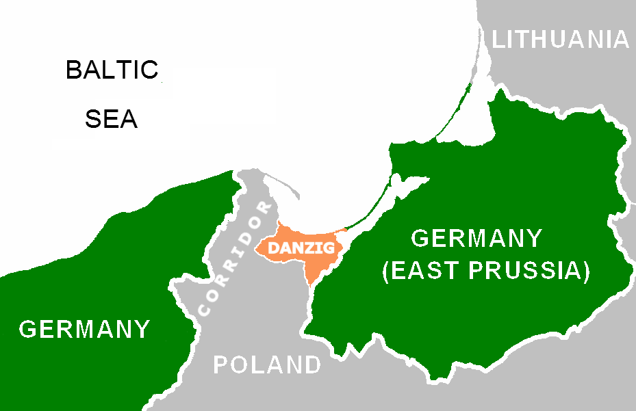
Polish Corridor
The Polish Corridor (German: Polnischer Korridor; Polish: korytarz polski), also known as the Pomeranian Corridor, was a territory located in the region of Pomerelia (Pomeranian Voivodeship, Eastern Pomerania), which provided the Second Polish Republic with access to the Baltic Sea, thus dividing the bulk of Weimar Germany from the province of East Prussia. At its narrowest point, the Polish territory was just 30 km wide. The Free City of Danzig (now the Polish cities of Gdańsk, Sopot and the surrounding areas), situated to the east of the corridor, was a semi-independent German speaking city-state forming part of neither Germany nor Poland, though united with the latter through an imposed union covering customs, mail, foreign policy, railways as well as defence.
After Poland lost Western Pomerania to Germany in the late 13th century, the area of Eastern Pomerania with the strategically important port of Gdańsk remained a narrow strip of land giving Poland access to the Baltic Sea and was also sometimes referred to as Pomeranian corridor.
According to German historian Hartmut Boockmann the term corridor was first used by Polish politicians, while Polish historian Grzegorz Lukomski writes that the word was coined by German nationalist propaganda of the 1920s. Internationally the term was used in English as early as March 1919 and whatever its origins it became a widespread term in English.
The equivalent German term is Polnischer Korridor. Polish names include korytarz polski ('Polish corridor') and korytarz gdański ('Gdańsk corridor'); however, reference to the region as a corridor came to be regarded as offensive by interwar Polish diplomats. Among the harshest critics of the term corridor was Polish Foreign Minister Józef Beck, who in his May 5, 1939 speech in the Sejm (Polish parliament) said: "I am insisting that the term Pomeranian Voivodeship should be used. The word corridor is an artificial idea, as this land has been Polish for centuries, with a small percentage of German settlers". Poles commonly referred to the region as Pomorze Gdańskie ('Gdańsk Pomerania', Pomerelia") or simply Pomorze ('Pomerania'), or as województwo pomorskie ('Pomeranian Voivodeship'), which was the administrative name for the region.
In the 10th century, Pomerelia was settled by Slavic Pomeranians, ancestors of the Kashubians, who were subdued by Bolesław I of Poland. In the 11th century, they created an independent duchy. In 1116/1121, Pomerania was again conquered by Poland. In 1138, following the death of Duke Bolesław III, Poland was fragmented into several semi-independent principalities. The Samborides, principes in Pomerelia, gradually evolved into independent dukes, who ruled the duchy until 1294. Before Pomerelia regained independence in 1227, their dukes were vassals of Poland and Denmark. Since 1308–1309, following succession wars between Poland and Brandenburg, Pomerelia was subjugated by the Monastic state of the Teutonic Knights in Prussia. In 1466, with the second Peace of Thorn, Pomerelia became part of the Polish–Lithuanian Commonwealth as a part of autonomous Royal Prussia. After the First Partition of Poland in 1772 it was annexed by the Kingdom of Prussia and named West Prussia, and became a constituent part of the new German Empire in 1871. Thus the Polish Corridor was not an entirely new creation: the territory assigned to Poland had been an integral part of Poland prior to 1772, but with a large degree of autonomy.
Perhaps the earliest census data on the ethnic and national structure of West Prussia (including areas which later made up the corridor) is from 1819.
Karl Andree, in Polen: in geographischer, geschichtlicher und culturhistorischer Hinsicht (Leipzig 1831), gives the total population of West Prussia as 700,000 – including 50% Poles (350,000), 47% Germans (330,000) and 3% Jews (20,000).
Data from the 19th century and early 20th century show the following ethnic changes in four main counties of the corridor (Puck and Wejherowo on the Baltic Sea coast; Kartuzy and Kościerzyna between the Province of Pomerania and Free City of Danzig):
Hub AI
Polish Corridor AI simulator
(@Polish Corridor_simulator)
Polish Corridor
The Polish Corridor (German: Polnischer Korridor; Polish: korytarz polski), also known as the Pomeranian Corridor, was a territory located in the region of Pomerelia (Pomeranian Voivodeship, Eastern Pomerania), which provided the Second Polish Republic with access to the Baltic Sea, thus dividing the bulk of Weimar Germany from the province of East Prussia. At its narrowest point, the Polish territory was just 30 km wide. The Free City of Danzig (now the Polish cities of Gdańsk, Sopot and the surrounding areas), situated to the east of the corridor, was a semi-independent German speaking city-state forming part of neither Germany nor Poland, though united with the latter through an imposed union covering customs, mail, foreign policy, railways as well as defence.
After Poland lost Western Pomerania to Germany in the late 13th century, the area of Eastern Pomerania with the strategically important port of Gdańsk remained a narrow strip of land giving Poland access to the Baltic Sea and was also sometimes referred to as Pomeranian corridor.
According to German historian Hartmut Boockmann the term corridor was first used by Polish politicians, while Polish historian Grzegorz Lukomski writes that the word was coined by German nationalist propaganda of the 1920s. Internationally the term was used in English as early as March 1919 and whatever its origins it became a widespread term in English.
The equivalent German term is Polnischer Korridor. Polish names include korytarz polski ('Polish corridor') and korytarz gdański ('Gdańsk corridor'); however, reference to the region as a corridor came to be regarded as offensive by interwar Polish diplomats. Among the harshest critics of the term corridor was Polish Foreign Minister Józef Beck, who in his May 5, 1939 speech in the Sejm (Polish parliament) said: "I am insisting that the term Pomeranian Voivodeship should be used. The word corridor is an artificial idea, as this land has been Polish for centuries, with a small percentage of German settlers". Poles commonly referred to the region as Pomorze Gdańskie ('Gdańsk Pomerania', Pomerelia") or simply Pomorze ('Pomerania'), or as województwo pomorskie ('Pomeranian Voivodeship'), which was the administrative name for the region.
In the 10th century, Pomerelia was settled by Slavic Pomeranians, ancestors of the Kashubians, who were subdued by Bolesław I of Poland. In the 11th century, they created an independent duchy. In 1116/1121, Pomerania was again conquered by Poland. In 1138, following the death of Duke Bolesław III, Poland was fragmented into several semi-independent principalities. The Samborides, principes in Pomerelia, gradually evolved into independent dukes, who ruled the duchy until 1294. Before Pomerelia regained independence in 1227, their dukes were vassals of Poland and Denmark. Since 1308–1309, following succession wars between Poland and Brandenburg, Pomerelia was subjugated by the Monastic state of the Teutonic Knights in Prussia. In 1466, with the second Peace of Thorn, Pomerelia became part of the Polish–Lithuanian Commonwealth as a part of autonomous Royal Prussia. After the First Partition of Poland in 1772 it was annexed by the Kingdom of Prussia and named West Prussia, and became a constituent part of the new German Empire in 1871. Thus the Polish Corridor was not an entirely new creation: the territory assigned to Poland had been an integral part of Poland prior to 1772, but with a large degree of autonomy.
Perhaps the earliest census data on the ethnic and national structure of West Prussia (including areas which later made up the corridor) is from 1819.
Karl Andree, in Polen: in geographischer, geschichtlicher und culturhistorischer Hinsicht (Leipzig 1831), gives the total population of West Prussia as 700,000 – including 50% Poles (350,000), 47% Germans (330,000) and 3% Jews (20,000).
Data from the 19th century and early 20th century show the following ethnic changes in four main counties of the corridor (Puck and Wejherowo on the Baltic Sea coast; Kartuzy and Kościerzyna between the Province of Pomerania and Free City of Danzig):