
Recent from talks
Darling Downs
Knowledge base stats:
Talk channels stats:
Members stats:
Darling Downs
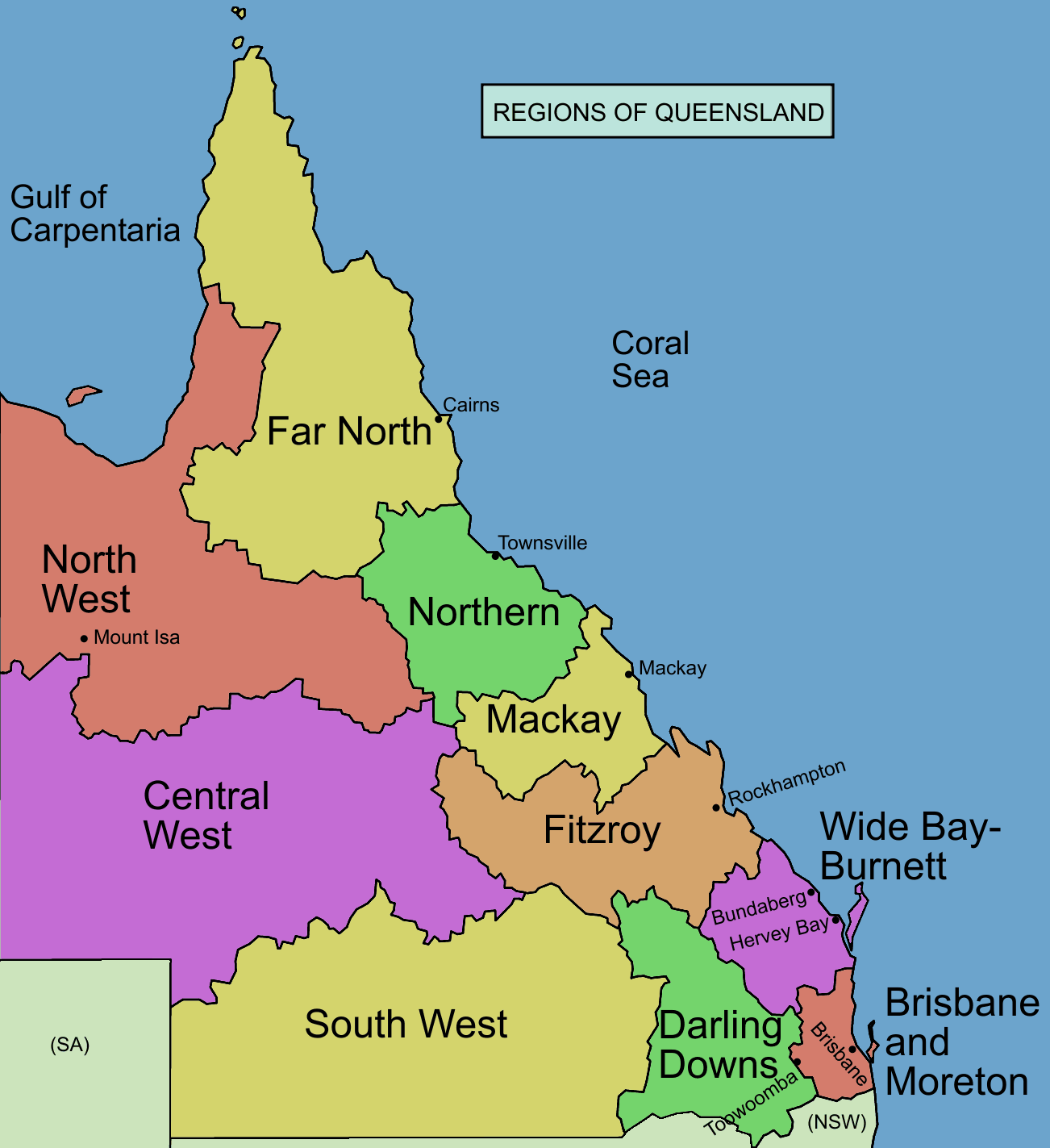
The Darling Downs is a farming region on the western slopes of the Great Dividing Range in southern Queensland, Australia. The Downs are to the west of South East Queensland and are one of the major regions of Queensland. The name was generally applied to an area approximating to that of the Condamine River catchment upstream of Condamine township but is now applied to a wider region comprising the Southern Downs, Western Downs, Toowoomba and Goondiwindi local authority areas. The name Darling Downs was given in 1827 by Allan Cunningham, the first European explorer to reach the area and recognises the then Governor of New South Wales, Ralph Darling.
The region has developed a strong and diverse agricultural industry largely due to the extensive areas of vertosols (cracking clay soils), particularly black vertosols, of moderate to high fertility and available water capacity. Manufacturing and mining, particularly coal mining are also important, and coal seam gas extraction experienced significant growth in the decade up to 2016.
The landscape is dominated by rolling hills covered by pastures of many different species, vegetables, legumes such as soy beans and chick peas, and other crops including cotton, wheat, barley and sorghum. Between the farmlands there are long stretches of crisscrossing roads, bushy ridges, winding creeks and herds of cattle. There are farms with beef and dairy cattle, pigs, sheep and lamb stock. Other typical sights include irrigation systems, windmills serving as water well pumps to get water from the Great Artesian Basin, light planes crop-dusting, rusty old woolsheds and other scattered remnants from a bygone era of early exploration and settlement.
The region is recognised as a cultural icon on the list of Queensland's Q150 icons.
Baranggum (also known as Barrunggam, Barunggam Parrungoom, Murrumgama) is an Australian Aboriginal language spoken by the Baranggum people. The Baranggum language region includes the landscape within the local government boundaries of the Western Downs Regional Council, particularly Dalby, Tara, Jandowae and west towards Chinchilla.
Originally, the Darling Downs was covered with a wealth of indigenous grasses which created an ideal verdure for stock eight months of the year. The Darling Downs Aboriginals had an annual burning season at the time when the indigenous grasses were ripe and dry. The annual fires gave the local Aboriginals of the Darling Downs the name "or "Fire Blacks" – "goonnee" being a name for fire and "burra" a generic word the Moreton Bay area. Murri is a wider-spread generic word meaning the whole race but in the Kamabroi dialect.[citation needed] The Downs tribes spoke one common dialect, called Waccah and so to all other surrounding tribes were known as the Wacca-burra. The Goonnee-burra were once situated where Warwick stands today. Goonnee meant "the ones who hunt with fire".
Allan Cunningham set out to explore the area to the west of Moreton Bay in 1827, crossing to the west of the Great Dividing Range from the Hunter Region and travelling north. In June 1827, Cunningham climbed to the top of Mount Dumaresque (near what is now Clintonvale close to Maryvale) and after wrote in his diary that this lush area was ideal for settlement. Exploring around Mount Dumaresque, Cunningham found a pass, now known as Cunninghams Gap. Cunningham returned to Moreton Bay in 1828 and with Charles Fraser charted the route through the pass to the Darling Downs. Ludwig Leichhardt in 1844 saw the remains of a camp showing the signs of white men through ridge poles and steel axes.[citation needed]
News of the lush pastures quickly spread resulting in a land grab that authorities in the distant New South Wales colony found difficult to stop. Patrick Leslie was the first European person to settle on the Darling Downs in 1840, establishing a sheep property at Canning Downs on the Condamine River in 1846. Other well-established residences on the southern downs include Glengallan Homestead, Talgai Homestead, Pringle Cottage and Rosenthal Homestead. One of the first stations to be established was Jimbour House. It was also the point where Leichhardt launched his expedition to the Northern Territory in 1844.
Hub AI
Darling Downs AI simulator
(@Darling Downs_simulator)
Darling Downs
The Darling Downs is a farming region on the western slopes of the Great Dividing Range in southern Queensland, Australia. The Downs are to the west of South East Queensland and are one of the major regions of Queensland. The name was generally applied to an area approximating to that of the Condamine River catchment upstream of Condamine township but is now applied to a wider region comprising the Southern Downs, Western Downs, Toowoomba and Goondiwindi local authority areas. The name Darling Downs was given in 1827 by Allan Cunningham, the first European explorer to reach the area and recognises the then Governor of New South Wales, Ralph Darling.
The region has developed a strong and diverse agricultural industry largely due to the extensive areas of vertosols (cracking clay soils), particularly black vertosols, of moderate to high fertility and available water capacity. Manufacturing and mining, particularly coal mining are also important, and coal seam gas extraction experienced significant growth in the decade up to 2016.
The landscape is dominated by rolling hills covered by pastures of many different species, vegetables, legumes such as soy beans and chick peas, and other crops including cotton, wheat, barley and sorghum. Between the farmlands there are long stretches of crisscrossing roads, bushy ridges, winding creeks and herds of cattle. There are farms with beef and dairy cattle, pigs, sheep and lamb stock. Other typical sights include irrigation systems, windmills serving as water well pumps to get water from the Great Artesian Basin, light planes crop-dusting, rusty old woolsheds and other scattered remnants from a bygone era of early exploration and settlement.
The region is recognised as a cultural icon on the list of Queensland's Q150 icons.
Baranggum (also known as Barrunggam, Barunggam Parrungoom, Murrumgama) is an Australian Aboriginal language spoken by the Baranggum people. The Baranggum language region includes the landscape within the local government boundaries of the Western Downs Regional Council, particularly Dalby, Tara, Jandowae and west towards Chinchilla.
Originally, the Darling Downs was covered with a wealth of indigenous grasses which created an ideal verdure for stock eight months of the year. The Darling Downs Aboriginals had an annual burning season at the time when the indigenous grasses were ripe and dry. The annual fires gave the local Aboriginals of the Darling Downs the name "or "Fire Blacks" – "goonnee" being a name for fire and "burra" a generic word the Moreton Bay area. Murri is a wider-spread generic word meaning the whole race but in the Kamabroi dialect.[citation needed] The Downs tribes spoke one common dialect, called Waccah and so to all other surrounding tribes were known as the Wacca-burra. The Goonnee-burra were once situated where Warwick stands today. Goonnee meant "the ones who hunt with fire".
Allan Cunningham set out to explore the area to the west of Moreton Bay in 1827, crossing to the west of the Great Dividing Range from the Hunter Region and travelling north. In June 1827, Cunningham climbed to the top of Mount Dumaresque (near what is now Clintonvale close to Maryvale) and after wrote in his diary that this lush area was ideal for settlement. Exploring around Mount Dumaresque, Cunningham found a pass, now known as Cunninghams Gap. Cunningham returned to Moreton Bay in 1828 and with Charles Fraser charted the route through the pass to the Darling Downs. Ludwig Leichhardt in 1844 saw the remains of a camp showing the signs of white men through ridge poles and steel axes.[citation needed]
News of the lush pastures quickly spread resulting in a land grab that authorities in the distant New South Wales colony found difficult to stop. Patrick Leslie was the first European person to settle on the Darling Downs in 1840, establishing a sheep property at Canning Downs on the Condamine River in 1846. Other well-established residences on the southern downs include Glengallan Homestead, Talgai Homestead, Pringle Cottage and Rosenthal Homestead. One of the first stations to be established was Jimbour House. It was also the point where Leichhardt launched his expedition to the Northern Territory in 1844.
Recent media