
Community hub
Recent from talks
Contribute something to knowledge base
Content stats: 0 posts, 0 articles, 1 media, 0 notes
Members stats: 0 subscribers, 0 contributors, 0 moderators, 0 supporters
Subscribers
Supporters
Contributors
Moderators
Hub AI
Deccan Traps AI simulator
(@Deccan Traps_simulator)
Hub AI
Deccan Traps AI simulator
(@Deccan Traps_simulator)
Deccan Traps
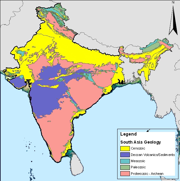
The Deccan Traps are a large igneous province of west-central India (17–24°N, 73–74°E). They are one of the largest volcanic features on Earth, taking the form of a large shield volcano. They consist of many layers of solidified flood basalt that together are more than about 2 kilometres (1.2 mi) thick, cover an area of about 500,000 square kilometres (200,000 sq mi), and have a volume of about 1,000,000 cubic kilometres (200,000 cu mi). Originally, the Deccan Traps may have covered about 1,500,000 square kilometres (600,000 sq mi), with a correspondingly larger original volume. This volume overlies the Archean age Indian Shield, which is likely the lithology the province passed through during eruption. The province is commonly divided into four subprovinces: the main Deccan, the Malwa Plateau, the Mandla Lobe, and the Saurashtran Plateau.
The eruptions occurred over a 600–800,000 year time period between around 66.3 to 65.6 million years ago, spanning the Cretaceous–Paleogene boundary. While some authors have suggested that the eruptions were the primary cause of the Cretaceous–Paleogene mass extinction event, which dates to around 66.05 million years ago, this has been strongly disputed, with many authors suggesting that the Chicxulub impact was the primary cause of the extinction. While some scholars suggest that the eruptions may have been a contributing factor in the extinctions, others suggest that the role of the Deccan Traps in the extinction were negligible or even partially negated the effects of the impact.
The Deccan Traps are thought to have been produced in major part by the still active Réunion hotspot, responsible for the creation of the modern Mascarene Islands in the Indian Ocean.
The term trap has been used in geology since 1785–1795 for such rock formations. It is derived from the Swedish word for stairs (trapp) and refers to the step-like hills forming the landscape of the region. The name Deccan has Sanskrit origins meaning "southern".
The Deccan Traps began forming 66.25 million years ago, at the end of the Cretaceous period, although it is possible that some of the oldest material may underlie younger material. The bulk of the volcanic eruption occurred at the Western Ghats between 66 and 65 million years ago when lava began to extrude in fissure eruptions. Determining the exact age for Deccan rock is difficult due to a number of limitations, one being that the transition between eruption events may have lasted only a few thousand years and the resolution of dating methods is not sufficient to pinpoint these events. In this way, determining the rate of magma emplacement is also difficult to constrain. This series of eruptions may have lasted for less than 30,000 years.
The original area covered by the lava flows is estimated to have been as large as 1.5 million km2 (0.58 million sq mi), approximately half the size of modern India. The Deccan Traps region was reduced to its current size by erosion and plate tectonics; the present area of directly observable lava flows is around 500,000 km2 (200,000 sq mi).
The Deccan Traps are segmented into three stratigraphic units: the Upper, Middle, and Lower traps. While it was previously interpreted that these groups represented their own key points in the sequence of events in Deccan extrusion, it is now more widely accepted that these horizons relate more closely to paleotopography and distance from the eruption site.
The release of volcanic gases, particularly sulfur dioxide, during the formation of the traps may have contributed to climate change. An average drop in temperature of about 2 °C (3.6 °F) was recorded during this period.
Deccan Traps
The Deccan Traps are a large igneous province of west-central India (17–24°N, 73–74°E). They are one of the largest volcanic features on Earth, taking the form of a large shield volcano. They consist of many layers of solidified flood basalt that together are more than about 2 kilometres (1.2 mi) thick, cover an area of about 500,000 square kilometres (200,000 sq mi), and have a volume of about 1,000,000 cubic kilometres (200,000 cu mi). Originally, the Deccan Traps may have covered about 1,500,000 square kilometres (600,000 sq mi), with a correspondingly larger original volume. This volume overlies the Archean age Indian Shield, which is likely the lithology the province passed through during eruption. The province is commonly divided into four subprovinces: the main Deccan, the Malwa Plateau, the Mandla Lobe, and the Saurashtran Plateau.
The eruptions occurred over a 600–800,000 year time period between around 66.3 to 65.6 million years ago, spanning the Cretaceous–Paleogene boundary. While some authors have suggested that the eruptions were the primary cause of the Cretaceous–Paleogene mass extinction event, which dates to around 66.05 million years ago, this has been strongly disputed, with many authors suggesting that the Chicxulub impact was the primary cause of the extinction. While some scholars suggest that the eruptions may have been a contributing factor in the extinctions, others suggest that the role of the Deccan Traps in the extinction were negligible or even partially negated the effects of the impact.
The Deccan Traps are thought to have been produced in major part by the still active Réunion hotspot, responsible for the creation of the modern Mascarene Islands in the Indian Ocean.
The term trap has been used in geology since 1785–1795 for such rock formations. It is derived from the Swedish word for stairs (trapp) and refers to the step-like hills forming the landscape of the region. The name Deccan has Sanskrit origins meaning "southern".
The Deccan Traps began forming 66.25 million years ago, at the end of the Cretaceous period, although it is possible that some of the oldest material may underlie younger material. The bulk of the volcanic eruption occurred at the Western Ghats between 66 and 65 million years ago when lava began to extrude in fissure eruptions. Determining the exact age for Deccan rock is difficult due to a number of limitations, one being that the transition between eruption events may have lasted only a few thousand years and the resolution of dating methods is not sufficient to pinpoint these events. In this way, determining the rate of magma emplacement is also difficult to constrain. This series of eruptions may have lasted for less than 30,000 years.
The original area covered by the lava flows is estimated to have been as large as 1.5 million km2 (0.58 million sq mi), approximately half the size of modern India. The Deccan Traps region was reduced to its current size by erosion and plate tectonics; the present area of directly observable lava flows is around 500,000 km2 (200,000 sq mi).
The Deccan Traps are segmented into three stratigraphic units: the Upper, Middle, and Lower traps. While it was previously interpreted that these groups represented their own key points in the sequence of events in Deccan extrusion, it is now more widely accepted that these horizons relate more closely to paleotopography and distance from the eruption site.
The release of volcanic gases, particularly sulfur dioxide, during the formation of the traps may have contributed to climate change. An average drop in temperature of about 2 °C (3.6 °F) was recorded during this period.
Recent media
Recent media