
Community hub
Recent from talks
Contribute something to knowledge base
Content stats: 0 posts, 0 articles, 1 media, 0 notes
Members stats: 0 subscribers, 0 contributors, 0 moderators, 0 supporters
Subscribers
Supporters
Contributors
Moderators
Hub AI
Des Moines River AI simulator
(@Des Moines River_simulator)
Hub AI
Des Moines River AI simulator
(@Des Moines River_simulator)
Des Moines River
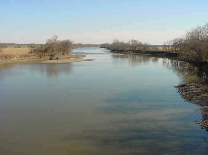
The Des Moines River (/dəˈmɔɪn/ ⓘ) is a tributary of the Mississippi River in the upper Midwestern United States that is approximately 525 miles (845 km) long from its farther headwaters. The largest river flowing across the state of Iowa, it rises in southern Minnesota and flows across Iowa from northwest to southeast, passing from the glaciated plains into the unglaciated hills, transitioning near the capital city of Des Moines in the center of the state. The river continues to flow in a southeastern direction away from Des Moines, flowing directly into the Mississippi River. The Des Moines River forms a short portion of Iowa's border with Missouri between Lee County, Iowa and Clark County, Missouri.
The city of Des Moines, Iowa, was named for the river.
In Minnesota, the upper forks of the Des Moines River drain the plateau and moraines between the Coteau des Prairies to the west, which is drained by the Big Sioux River, and the lower lands to the east which drain northward into the Blue Earth and Minnesota Rivers.
The Des Moines River rises in two forks. The West Fork (the main branch) rises out of the wetlands surrounding Lake Yankton and Long Lake in Lyon County in southwestern Minnesota. The small stream flows southwest into Lake Shetek, then through Windom and Jackson, Minnesota, and near Estherville, Iowa. The East Fork rises out in rural Martin County, Minnesota, just north of Interstate 90. It then flows through Okamanpeedan Lake on the Iowa-Minnesota border, then south, through Algona. The two forks join in southern Humboldt County, approximately 5 miles (8 km) south of Humboldt at Frank Gotch State Park.
The combined stream flows roughly southward through Fort Dodge. South of Boone it passes through the Ledges State Park. It flows through downtown Des Moines, then turns generally southeastward, flowing through Ottumwa. It forms approximately 20 miles (32 km) of the border between Iowa and Missouri before joining the Mississippi from the northwest at Keokuk.
It receives the Boone River from the northeast approximately 20 miles (32 km) southwest of Fort Dodge. It receives the Raccoon River from the west in the city of Des Moines. Above the city of Des Moines, it is impounded to create the Saylorville Lake reservoir. About midway below Saylorville and above Ottumwa, near Pella, the river is impounded to create the Lake Red Rock reservoir.
One of the earliest French maps that depicts the Des Moines (1703) refers to it as "R. des Otentas", which translates to "River of the Otoe"; the Otoe Tribe lived in the interior of Iowa in the 18th century. The Meskwaki and Sauk people referred to the river as "Ke-o-shaw-qua" (Hermit's River), from which Keosauqua, Iowa, derives its name. The Dakota Indians, who lived near its headwaters in present-day Minnesota, referred to it as "Inyan Shasha" in their Siouan language. Another Siouan name was "Eah-sha-wa-pa-ta," or "Red Stone" river, possibly referring to the bluffs at Red Rock or the reddish Sioux Quartzite bedrock near its headwaters.
The origin of the name Des Moines is obscure. Early French explorers named it La Rivière des Moines, literally meaning "River of the Monks". The name may have referred to early Trappist monks who built huts near the mouth of the river at the Mississippi.[citation needed]
Des Moines River
The Des Moines River (/dəˈmɔɪn/ ⓘ) is a tributary of the Mississippi River in the upper Midwestern United States that is approximately 525 miles (845 km) long from its farther headwaters. The largest river flowing across the state of Iowa, it rises in southern Minnesota and flows across Iowa from northwest to southeast, passing from the glaciated plains into the unglaciated hills, transitioning near the capital city of Des Moines in the center of the state. The river continues to flow in a southeastern direction away from Des Moines, flowing directly into the Mississippi River. The Des Moines River forms a short portion of Iowa's border with Missouri between Lee County, Iowa and Clark County, Missouri.
The city of Des Moines, Iowa, was named for the river.
In Minnesota, the upper forks of the Des Moines River drain the plateau and moraines between the Coteau des Prairies to the west, which is drained by the Big Sioux River, and the lower lands to the east which drain northward into the Blue Earth and Minnesota Rivers.
The Des Moines River rises in two forks. The West Fork (the main branch) rises out of the wetlands surrounding Lake Yankton and Long Lake in Lyon County in southwestern Minnesota. The small stream flows southwest into Lake Shetek, then through Windom and Jackson, Minnesota, and near Estherville, Iowa. The East Fork rises out in rural Martin County, Minnesota, just north of Interstate 90. It then flows through Okamanpeedan Lake on the Iowa-Minnesota border, then south, through Algona. The two forks join in southern Humboldt County, approximately 5 miles (8 km) south of Humboldt at Frank Gotch State Park.
The combined stream flows roughly southward through Fort Dodge. South of Boone it passes through the Ledges State Park. It flows through downtown Des Moines, then turns generally southeastward, flowing through Ottumwa. It forms approximately 20 miles (32 km) of the border between Iowa and Missouri before joining the Mississippi from the northwest at Keokuk.
It receives the Boone River from the northeast approximately 20 miles (32 km) southwest of Fort Dodge. It receives the Raccoon River from the west in the city of Des Moines. Above the city of Des Moines, it is impounded to create the Saylorville Lake reservoir. About midway below Saylorville and above Ottumwa, near Pella, the river is impounded to create the Lake Red Rock reservoir.
One of the earliest French maps that depicts the Des Moines (1703) refers to it as "R. des Otentas", which translates to "River of the Otoe"; the Otoe Tribe lived in the interior of Iowa in the 18th century. The Meskwaki and Sauk people referred to the river as "Ke-o-shaw-qua" (Hermit's River), from which Keosauqua, Iowa, derives its name. The Dakota Indians, who lived near its headwaters in present-day Minnesota, referred to it as "Inyan Shasha" in their Siouan language. Another Siouan name was "Eah-sha-wa-pa-ta," or "Red Stone" river, possibly referring to the bluffs at Red Rock or the reddish Sioux Quartzite bedrock near its headwaters.
The origin of the name Des Moines is obscure. Early French explorers named it La Rivière des Moines, literally meaning "River of the Monks". The name may have referred to early Trappist monks who built huts near the mouth of the river at the Mississippi.[citation needed]
Recent media
Recent media