Hubbry Logo
Desertas IslandsDesertas IslandsMain
Open search
Desertas Islands
Community hub
Desertas Islands
logo
8 pages, 0 posts
0 subscribers
Be the first to start a discussion here.
Desertas Islands
Desertas Islands
from Wikipedia

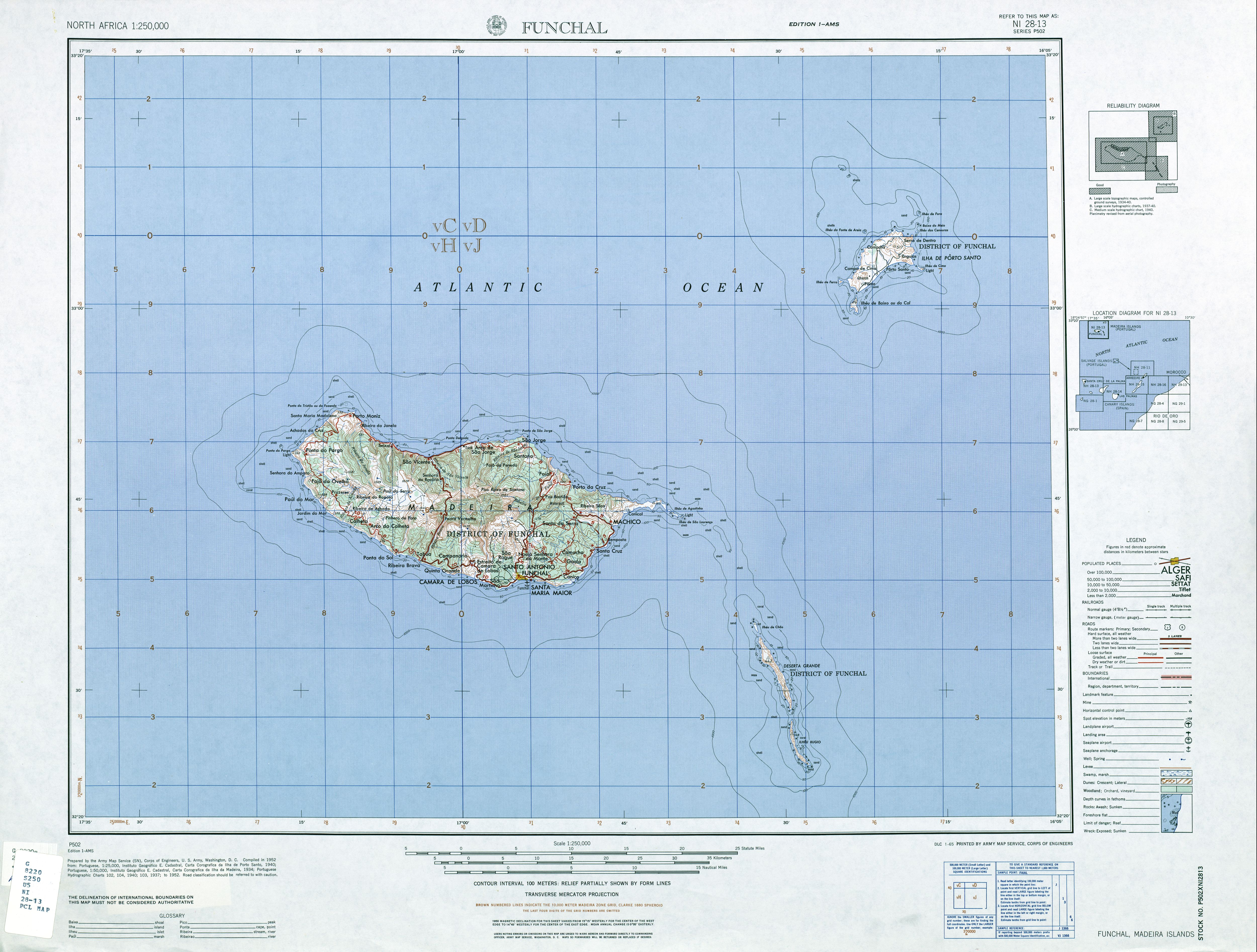
The Desertas Islands (Portuguese: Ilhas Desertas, IPA: [ˈiʎɐʒ ðɨˈzɛɾtɐʃ], "Deserted Islands") are a small archipelago in the Atlantic Ocean, part of the larger Portuguese Madeira Archipelago.

Key Information

The archipelago is located off the coast of Morocco. Deserta Grande Island is located about 25 kilometres (16 mi) southeast of the eastern tip of Madeira Island, Ponta de São Lourenço.

Geography

[edit]
Aerial view of the Desertas Islands (Ilhas Desertas)

The archipelago of the Desertas Islands is a chain of three long and narrow islands that stretch over a north/south distance of 22.3 kilometres (13.9 mi). The Desertas Islands, from north to south with approximate area figures, are:

Island Area (km2) Height (m)
Chão Islet 1 98
Deserta Grande 10 442
Bugio 3 348
TOTAL 14.21 442

Administration

[edit]

Administratively, the islands are part of the Municipality of Santa Cruz in Madeira, and in the Santa Cruz civil parish.

The islands are a designated Portuguese nature reserve. A licence is needed to land there.

Natural history

[edit]
Nature reserve warden's house on Deserta Grande Island
Paul Alexander Zino

Though near the main island of Madeira, where the islands can often be seen on the horizon, the geology of the Ilhas Desertas is starkly different. The high, long, and rocky islands of the group are barren of topsoil, and the only vertebrate wildlife consists of about sixteen species of birds, including eight species of seabirds, and a scarce population of feral goats, rabbits, and rodents, brought from Portugal by the mariners who first reached the rocky shores. The Deserta Grande wolf spider and Madeiran wall lizard also exist in the fragile and arid ecosystem. There are a number of endemic arthropods and other invertebrates, however, that are more poorly studied.[1] These include two species of endemic land snail: Discula lyelliana and Geomitra grabhami.[2] They had not been observed for over a century, and were presumed extinct by the early 21st century. However, during conservation expeditions conducted between 2012 and 2017, experts from the Institute for Nature Conservation and Forests rediscovered small populations of the two snail species, each with fewer than 200 individuals. These snails were transferred to zoos in the UK and France and successfully bred in captivity. In 2024, more than 1300 of them were reintroduced to the wild on Bugio Island.[3]

The only inhabitable island, with its own water source, is Deserta Grande. This water is murky and scarce, and historic attempts to colonise the island failed due to the impracticability of agriculture.

A tiny colony of Mediterranean monk seals inhabits the beaches, and since 1990 the islands have been constituted as a nature reserve for their protection. In 1998, the colony numbered only eight; now the population is approximately forty seals. The only humans on the islands are the permanent wardens, geologists, occasional boaters, and those who work at the few research stations.

Important Bird Area

[edit]

The Desertas archipelago has been recognised as an Important Bird Area (IBA) by BirdLife International because of its seabird colonies. These include Fea's and Bulwer's petrels, Cory's and Barolo shearwaters, band-rumped storm petrels, common terns and Caspian gulls.[4]

See also

[edit]

References

[edit]
[edit]
Revisions and contributorsEdit on WikipediaRead on Wikipedia
from Grokipedia
The Desertas Islands are a small, uninhabited volcanic in the North , forming part of Portugal's autonomous region of and located approximately 22 nautical miles (about 40 km) southeast of . The group consists of three main islands—Deserta Grande (the largest, 12 km long and rising to 479 m), Bugio (7.5 km long and up to 388 m high), and Ilhéu Chão (1.6 km long)—along with several smaller islets and a surrounding marine area, covering a total land area of roughly 14 km² within a protected zone of 11,457 hectares. Of volcanic origin and approximately 3.5 million years old, the islands feature rugged, arid terrain with steep coastal escarpments, minimal freshwater sources, and sparse vegetation adapted to semi-desert conditions, reflecting remnants of ancient subtropical . Discovered by navigators in the early during the exploration of the archipelago, the Desertas Islands saw several failed attempts at , including the introduction of , rabbits, and other animals that later became invasive threats to native ecosystems. Privately owned until 1971, when they were acquired by the Portuguese state, the islands were historically used for and but remained largely unsettled due to their harsh environment. Legal protection began in 1990 as a , escalating to full status in 1995 under management by the Madeira Natural Park (Parque Natural da Madeira), with inclusion in the European network as both a Site of Community Importance (SAC) and (SPA) since 2009. Ecologically, the Desertas Islands are a within the Macaronesian biogeographic region, hosting over 200 species—including 37 endemics to and 20 to —and serving as a key refuge for threatened fauna. Notable wildlife includes the critically endangered Mediterranean (Monachus monachus), with a stable population of approximately 27 individuals (as of 2021) representing one of Europe's last strongholds; the vulnerable Desertas (Pterodroma deserta, 160–180 breeding pairs); Bulwer's (Bulweria bulwerii, up to 45,000 pairs); an endemic subspecies of (Teira dugesii mauli); and unique such as 44 endemic mollusc species and over 300 arthropods, including the Desertas tarantula (Hogna ingens). Designated an (IBA) and biogenetic reserve, the archipelago's marine and terrestrial habitats support high and scientific value, though they face ongoing challenges from and . Human access is strictly regulated to preserve this pristine , with permits required for visits limited to conservation, research, or guided tours (capped at 250 visitors per day and 2,500 per month), prohibiting activities like fishing, anchoring, or collecting specimens. Conservation efforts, supported by projects, focus on eradicating invasives (e.g., from Deserta Grande, Argentine from Ilhéu Chão), monitoring monk seals, and habitat restoration, including the 2024 reintroduction of endemic land snails to Bugio Island; earning the reserve the Council of Europe's European Diploma for Protected Areas in recognition of its exemplary management.

Geography

Location and Physical Features

The Desertas Islands form a small in the North , situated approximately 25 km southeast of the eastern tip of at coordinates around 32°30′N 16°30′W. They are administratively part of the autonomous region of in . The covers a total land area of about 14.2 km² and comprises three main islands—Deserta Grande, Bugio, and Ilhéu Chão—along with several surrounding islets. Deserta Grande dominates the group with an area of approximately 10 km², while Bugio spans about 3 km² and Ilhéu Chão about 0.4 km². Deserta Grande extends 12 km in length and up to 2 km in width, characterized by arid, mountainous terrain rising to steep cliffs and a maximum of 479 m. Bugio measures 7.5 km long and 0.7 km wide with peaks up to 388 m, while Ilhéu Chão is a compact plateau 1.6 km long and 0.5 km wide, reaching 98 m in height. These islands originated from volcanic activity associated with the broader hotspot. Surrounding the islands is the Desertas Plateau, a submarine ridge that forms part of the underwater topography extending from . The archipelago lies within Portugal's for the Madeira region, which spans approximately 454,000 km² and extends 200 nautical miles from the baselines.

Geology and Climate

The Desertas Islands originated from volcanic activity associated with the Madeira hotspot, a that has influenced in the eastern North Atlantic for over 70 million years. on the islands occurred primarily during the to epochs, spanning approximately 5.1 to 1.9 million years ago, as part of the shield-building phase of the broader Madeira-Desertas volcanic complex. This activity formed a northwest-southeast trending , characterized by aligned eruptive centers and parallel dyke swarms, with the islands emerging through successive eruptions along this structure. Although no calderas are prominently featured, the includes evidence of extensive ancient lava flows and intrusive dikes, reflecting a rift-dominated without recent eruptive activity. Current seismic tremors in the region are linked to tectonic stresses from the nearby , but the islands themselves exhibit no active . The islands' rock composition is dominated by alkaline mafic rocks, including alkali basalts, basanites, and hawaiites, with minor occurrences of more evolved types such as benmoreites. These materials were extruded during the rift phases, forming thick sequences of subhorizontal lava flows interspersed with pyroclastic deposits from explosive interactions between and . The volcanic edifice has since undergone significant , exposing the underlying structures and contributing to the islands' rugged . The of the Desertas Islands is classified as subtropical oceanic with Mediterranean influences, characterized by mild temperatures and low . Annual rainfall averages approximately 400 mm, predominantly occurring during the winter months from to , while summers remain largely dry. Mean temperatures range from 15°C in winter to 25°C in summer, moderated by the surrounding Atlantic waters. Frequent , generated by the cooling of moist air masses, is common, particularly on windward slopes, alongside persistent strong northeast that can reach speeds of up to 50 km/h. These climatic conditions promote intense on the steep, exposed terrains, resulting in thin, rocky soils and an overall desert-like landscape despite the islands' oceanic setting.

History

Discovery and Early Exploration

The Desertas Islands were first referenced in European records during the , appearing on a Venetian dated 1351 that depicted them alongside Porto Santo and the Selvagens Islands as remote Atlantic features. This early cartographic mention suggests prior knowledge among Mediterranean navigators, though no detailed explorations are recorded from that period. The islands were officially discovered by explorers in as part of the broader reconnaissance of the , led by under the patronage of Dom Henrique. Zarco, who had previously identified Porto Santo in 1418, sighted the Desertas during subsequent voyages and named them "Ilhas Desertas" owing to their arid, barren landscape devoid of vegetation and apparent habitability. Early accounts highlighted the 's extreme isolation, approximately 40 kilometers southeast of , and the scarcity of , rendering them unsuitable for immediate settlement. Portugal formally claimed the Desertas in the , integrating them administratively into the holdings granted by ; this followed initial mapping efforts influenced by 14th-century Italian portolans, such as those by the Pizzigani brothers in 1367 and the of 1375, which broadly outlined the region's insular features. By the , Portuguese captains conducted further surveys, confirming the islands' unyielding terrain and absence of any pre-European human artifacts or settlements, while occasionally linking them to medieval legends of phantom Atlantic isles like Antilia, though such associations remain speculative without supporting evidence.

Human Activity and Settlement Attempts

Following the discovery of the Desertas Islands by navigators in the early , human activity primarily involved the introduction of as a reliable food source for potential settlers and shipwreck survivors. These animals, released by order of D. Henrique before 1460, proliferated unchecked, resulting in severe that stripped the islands' fragile vegetation, accelerated , and fundamentally altered the ecosystems through the . In the , emerged as a key economic pursuit in the surrounding Atlantic waters, with temporary stations and lookout points established on Deserta Grande by British and American whalers, alongside operators, targeting sperm whales from the 1850s to the 1870s. These facilities included stone tanks for rendering and elevated posts for spotting pods, contributing to the depletion of local populations while providing brief seasonal human presence on the otherwise barren island. Settlement efforts intensified in the late , as Portuguese families from attempted to farm the islands in the 1890s, constructing rudimentary stone walls, water catchment systems, and shelters on Deserta Grande in hopes of . However, the persistent and extreme arid conditions—exacerbated by the ongoing effects of goat —rendered these ventures untenable, leading to their abandonment by 1900 and confirming the islands' uninhabitability for permanent communities. From 1894 until 1971, the islands were privately owned, primarily by families from (including English residents), who used them for and limited of introduced . In 1971, the Portuguese state acquired the Desertas Islands, marking the end of private exploitation and facilitating their transition to protected status. By the , exploitation gave way to scientific inquiry, with early estimates indicating critically low populations of species like the , around 25 individuals across the archipelago. These assessments represented an early pivot toward ecological evaluation, laying groundwork for later conservation initiatives amid the islands' mounting environmental challenges.

Biodiversity

Flora

The flora of the Desertas Islands comprises over 200 indigenous and naturalized species of vascular plants (phanerogams), reflecting the archipelago's isolation within the Macaronesian region. Among these, approximately 10%—around 20 species—are restricted to Macaronesia, while 30% are endemic to the broader Madeira archipelago, with only a few (e.g., 2-4) strictly endemic to Desertas, such as Musschia isambertoi and Sinapidendron sempervivifolium. Notable endemics include Chamaemeles coriacea, a priority species under conservation frameworks, Monizia edulis, Musschia aurea, and Musschia isambertoi, the latter critically endangered and restricted to these islands. These plants exhibit adaptations to the islands' arid, rocky substrates, such as succulent leaves and deep root systems that enable survival in low-rainfall conditions. Vegetation is dominated by drought-resistant shrubs and succulents, forming remnants of Macaronesian laurisilva-influenced communities in more sheltered areas, alongside open arid scrub. Key associations include the , characterized by the succulent , which thrives in exposed, coastal slopes and provides structural cover in otherwise sparse habitats. Other representative species in these scrub formations include Frankenia sp. (halophytic shrubs) and various endemics, contributing to a low, patchy canopy that withstands strong winds and salt spray. Bryophytes, such as the Desertas-exclusive Frullania sergiae, further diversify microhabitats in damp crevices. Plant zonation follows elevational and exposure gradients, with coastal areas at to 360 m featuring salt-tolerant herbs and low shrubs like Monizia edulis and maderensis in halophytic zones near shorelines. Higher slopes (300–480 m) transition to arid scrub dominated by species such as Lotus argyrodes and haematomma, which form denser patches on outcrops amid the prevailing . These patterns highlight the islands' ecological stratification, where maritime influences yield to montane dryness. Invasive species, particularly feral goats introduced historically, severely impacted native flora by overgrazing succulents and shrubs, reducing cover in scrub communities and threatening endemics like Musschia isambertoi through direct herbivory. Partial removal efforts began in the 1990s, including the removal of over 100 goats from Deserta Grande, with ongoing culling to control the population and facilitate recovery, including post-management actions such as native plant reseeding promoting regeneration of Euphorbietum piscatoriae and associated vegetation on islands like Bugio and Deserta Grande. In 2025, endemic snails were reintroduced to a neighboring islet to mitigate ongoing goat threats.

Fauna

The Desertas Islands support a diverse avifauna dominated by seabirds, with more than 15 breeding species recorded and no native terrestrial birds establishing significant populations due to the arid conditions and isolation. Key breeding populations include the Madeiran (Hydrobates castro, formerly Oceanodroma castro), which nests in burrows across the islands with an estimated 1,000 pairs; Bulwer's (Bulweria bulwerii), hosting the largest Atlantic colony of up to 45,000 pairs across the islands, primarily on Deserta Grande; and Desertas (Pterodroma deserta), with approximately 200 pairs (as of ) breeding exclusively on Bugio in . Recent studies () reveal that Desertas petrels track tropical cyclones for enhanced foraging opportunities. These species utilize the steep cliffs and plateaus for nesting, benefiting from the islands' remoteness that limits predation, though invasive Argentine ants prey on nestlings. The islands harbor notable endemic invertebrates, particularly among arthropods, with over 100 unique and endemic to Desertas adapted to the harsh, isolated environment, including flightless ground beetles (Coleoptera: Carabidae) that exhibit reduced dispersal capabilities, contributing to a total of approximately 300 arthropods. A prominent example is the critically endangered Desertas wolf (), one of the world's largest with a leg span up to 12 cm, restricted to a single valley on Deserta Grande where it preys on and small vertebrates. Recent surveys have identified 32 additional endemic on Deserta Grande alone, underscoring the archipelago's role in driven by volcanic isolation. Reptilian fauna is limited but includes the rare endemic subspecies of the Madeira wall lizard (Teira dugesii mauli), the only terrestrial reptile on the islands, adapted to rocky outcrops and feeding primarily on insects in the sparse vegetation. Marine mammals frequent the surrounding waters, with the Desertas serving as a critical breeding site for the endangered (Monachus monachus), supporting a resident population of approximately 20-25 individuals (as of 2023) that use coastal caves for pupping and resting. The area also attracts cetaceans such as sperm whales (Physeter macrocephalus) and bottlenose dolphins (Tursiops truncatus), which utilize the deep offshore waters for foraging.

Conservation and Administration

Protected Status and Management

The Desertas Islands were designated as a (SPA) under the European Union's Birds Directive in 1990, recognizing their importance for the conservation of wild bird species, including several seabirds. This designation was followed in 1995 by classification as a under Regional Legislative Decree No. 9/95/M, administered by the Regional Government of , which encompasses the entire —comprising Deserta Grande, Ilhéu Chão, and Bugio—and approximately 11,457 hectares (114 km²) of surrounding to the 100 m isobath to protect both terrestrial and coastal ecosystems. The islands also hold status as a Site of Community Importance (SCI) under the EU , proposed in 1995 and confirmed in 2001, further safeguarding their unique biodiversity through integrated environmental measures. Management of the is overseen by the Instituto das Florestas e Conservação da Natureza (IFCN), a public institute under the Regional Government of responsible for and biodiversity planning across the . Key initiatives have focused on control to restore native habitats; notably, a LIFE Nature project (LIFE95 NAT/P/000125) successfully eradicated feral goats from Deserta Grande between 1996 and 1998, eliminating a major threat to vegetation and soil stability after centuries of browsing pressure. Ongoing efforts target invasive plants, such as the ice plant (), through manual removal and monitoring to prevent encroachment on endemic flora and support recovery of degraded areas, as well as eradication of Argentine ants (Linepithema humile) from Ilhéu Chão to protect colonies. Conservation strategies include dedicated monitoring programs for priority species, particularly the critically endangered Mediterranean monk seal (Monachus monachus) and seabirds like Bulwer's petrel (Bulweria bulwerii). Systematic surveys of monk seal populations and behaviors began in the late 1980s, with a permanent research station established on Deserta Grande to facilitate year-round observations, photo-identification, and habitat assessments by wardens and scientists. These programs track population trends—revealing a recovery to approximately 30 individuals as of 2023—and breeding success for petrels, while enforcing strict access restrictions to minimize human disturbance.

Access and Tourism

Access to the Desertas Islands is strictly controlled by the Madeira Natural Park Services (SPNM) to preserve their fragile and . All visits require prior authorization through a issued by the SPNM, and independent is prohibited; access is permitted only via licensed maritime tourist vessels or private boats for approved purposes such as scientific research, educational programs, or guided eco-tourism. The primary mode of reaching the islands is by boat departing from on , with journeys typically lasting 2.5 to 5 hours depending on weather and vessel type. access is occasionally used for personnel but is not available for general visitors. No permanent visitor facilities, such as accommodations or overnight options, exist on the islands; all excursions operate as full-day trips with return to the same day. Guided tours, conducted by SPNM-licensed operators, emphasize low-impact activities like for seabird colonies and observation of the endangered from designated viewpoints. These tours provide educational insights into the islands' unique and while adhering to protocols that minimize disturbance, such as restricted landing sites primarily on Deserta Grande. Annual visitor numbers are capped through these regulations, with approximately 4,000 to 5,000 participants recorded in recent years, supporting conservation funding via tour fees. Following the recovery of regional after , interest in Desertas eco-tours has grown alongside 's overall visitor surge, yet strict quotas and seasonal restrictions maintain ecological balance. As a within the Madeira Natural Park, these measures ensure tourism complements rather than compromises protection efforts.

References

Add your contribution
Related Hubs
User Avatar
No comments yet.