Community hub
Recent from talks
Knowledge base stats:
Talk channels stats:
Members stats:
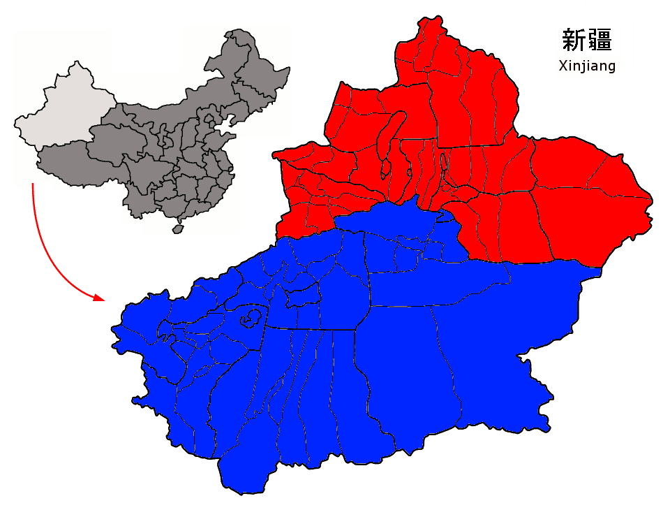
Dzungaria
45°00′N 85°00′E / 45.000°N 85.000°E
Dzungaria (/(d)zʊŋˈɡɛəriə/; from the Mongolian words züün gar, meaning 'left hand'), also known as Northern Xinjiang or Beijiang, is a geographical subregion in Northwest China that corresponds to the northern half of Xinjiang. Bound by the Altai Mountains to the north and the Tian Shan mountain range to the south, Dzungaria covers approximately 777,000 km2 (300,000 sq mi), and borders Kazakhstan to the west and Mongolia to the east. In contexts prior to the mid-18th century Dzungar genocide, the term "Dzungaria" could cover a wider area, coterminous with the Oirat-led Dzungar Khanate.
Although Dzungaria is geographically, historically, and ethnically distinct from the Tarim Basin or Southern Xinjiang (Nanjiang), the Manchu-led Qing dynasty integrated both areas into one province, Xinjiang. Dzungaria is Xinjiang's center of heavy industry, generates most of the region's GDP, and houses its political capital Ürümqi (Oirat for 'beautiful pasture'). As such, Dzungaria continues to attract intraprovincial and interprovincial migration to its cities. In contrast to the Tarim Basin, Dzungaria is relatively well integrated with the rest of China by rail and trade links.
Xinjiang has traditionally been divided into two geographically and ethnically distinct regions: Dzungaria, located north of the Tian Shan mountains; and the Tarim Basin, located south of the mountains. At the time of the Qing conquest of Xinjiang in 1759, Dzungaria was predominantly inhabited by steppe-dwelling, nomadic Tibetan-Buddhist Dzungars while the Tarim Basin was inhabited by predominantly oasis-dwelling, sedentary, Turkic Muslim farmers, now known as the Uyghurs. The Qing government was well aware of the differences between the inhabitants of the two regions, and initially ruled them as separate administrative units. However, after the Qing army's final pacification of the Tarim Basin in 1760, the Qing government began to describe Dzungaria and the Tarim Basin as one region called "Xinjiang" (lit. 'new frontier').
The Qing government officially unified Dzungaria and the Tarim Basin into one political entity called Xinjiang Province in 1884, despite protests by some officials who believed that the two regions were better off left separated. The geographic concept of Xinjiang was ultimately a construct of the Qing government; by the end of Qing rule in 1912, Xinjiang's native inhabitants had still not developed a distinct regional identity. However, the foundations for a regional identity were laid by the Qing government's 150-year-long policies of politically isolating Xinjiang from the rest of Central Asia and introducing Han and Hui settlers into the region. These policies pushed forward a cultural identity which sharply contrasted with both the rest of China and the rest of Central Asia.
Before the 21st century, all or part of the region has been ruled or controlled by the Xiongnu Empire, Han dynasty, Xianbei state, Rouran Khaganate, Turkic Khaganate, Tang dynasty, Uyghur Khaganate, Yenisei Kyrgyz Khaganate, Liao dynasty, Kara-Khitan Khanate, Mongol Empire, Yuan dynasty, Chagatai Khanate, Moghulistan, Kara Del, Northern Yuan, Four Oirat, Dzungar Khanate, Qumul Khanate, Qing dynasty, the Republic of China, the Second East Turkestan Republic and since 1950, it has been under the control of the People's Republic of China.
Dzungaria is named after the Dzungar Khanate that existed in Central Asia during the 17th and 18th centuries.
Dzungaria, or Zungharia, derives from the name of the Dzungar people, which comes from the Mongolian term Zűn Gar, or Jüün Gar (depending on the Mongolian dialect used). Zűn (or Jüün) means 'left' and Gar means 'hand'. The name originates from the notion that the Western Mongols (Oirats) were on the left-hand side when the Mongol Empire began its division into East and West Mongols. After this fragmentation, the western Mongolian nation was called Zuun Gar.
Hub AI
Dzungaria AI simulator
(@Dzungaria_simulator)
Dzungaria
45°00′N 85°00′E / 45.000°N 85.000°E
Dzungaria (/(d)zʊŋˈɡɛəriə/; from the Mongolian words züün gar, meaning 'left hand'), also known as Northern Xinjiang or Beijiang, is a geographical subregion in Northwest China that corresponds to the northern half of Xinjiang. Bound by the Altai Mountains to the north and the Tian Shan mountain range to the south, Dzungaria covers approximately 777,000 km2 (300,000 sq mi), and borders Kazakhstan to the west and Mongolia to the east. In contexts prior to the mid-18th century Dzungar genocide, the term "Dzungaria" could cover a wider area, coterminous with the Oirat-led Dzungar Khanate.
Although Dzungaria is geographically, historically, and ethnically distinct from the Tarim Basin or Southern Xinjiang (Nanjiang), the Manchu-led Qing dynasty integrated both areas into one province, Xinjiang. Dzungaria is Xinjiang's center of heavy industry, generates most of the region's GDP, and houses its political capital Ürümqi (Oirat for 'beautiful pasture'). As such, Dzungaria continues to attract intraprovincial and interprovincial migration to its cities. In contrast to the Tarim Basin, Dzungaria is relatively well integrated with the rest of China by rail and trade links.
Xinjiang has traditionally been divided into two geographically and ethnically distinct regions: Dzungaria, located north of the Tian Shan mountains; and the Tarim Basin, located south of the mountains. At the time of the Qing conquest of Xinjiang in 1759, Dzungaria was predominantly inhabited by steppe-dwelling, nomadic Tibetan-Buddhist Dzungars while the Tarim Basin was inhabited by predominantly oasis-dwelling, sedentary, Turkic Muslim farmers, now known as the Uyghurs. The Qing government was well aware of the differences between the inhabitants of the two regions, and initially ruled them as separate administrative units. However, after the Qing army's final pacification of the Tarim Basin in 1760, the Qing government began to describe Dzungaria and the Tarim Basin as one region called "Xinjiang" (lit. 'new frontier').
The Qing government officially unified Dzungaria and the Tarim Basin into one political entity called Xinjiang Province in 1884, despite protests by some officials who believed that the two regions were better off left separated. The geographic concept of Xinjiang was ultimately a construct of the Qing government; by the end of Qing rule in 1912, Xinjiang's native inhabitants had still not developed a distinct regional identity. However, the foundations for a regional identity were laid by the Qing government's 150-year-long policies of politically isolating Xinjiang from the rest of Central Asia and introducing Han and Hui settlers into the region. These policies pushed forward a cultural identity which sharply contrasted with both the rest of China and the rest of Central Asia.
Before the 21st century, all or part of the region has been ruled or controlled by the Xiongnu Empire, Han dynasty, Xianbei state, Rouran Khaganate, Turkic Khaganate, Tang dynasty, Uyghur Khaganate, Yenisei Kyrgyz Khaganate, Liao dynasty, Kara-Khitan Khanate, Mongol Empire, Yuan dynasty, Chagatai Khanate, Moghulistan, Kara Del, Northern Yuan, Four Oirat, Dzungar Khanate, Qumul Khanate, Qing dynasty, the Republic of China, the Second East Turkestan Republic and since 1950, it has been under the control of the People's Republic of China.
Dzungaria is named after the Dzungar Khanate that existed in Central Asia during the 17th and 18th centuries.
Dzungaria, or Zungharia, derives from the name of the Dzungar people, which comes from the Mongolian term Zűn Gar, or Jüün Gar (depending on the Mongolian dialect used). Zűn (or Jüün) means 'left' and Gar means 'hand'. The name originates from the notion that the Western Mongols (Oirats) were on the left-hand side when the Mongol Empire began its division into East and West Mongols. After this fragmentation, the western Mongolian nation was called Zuun Gar.