
Community hub
Recent from talks
Contribute something
Nothing was collected or created yet.
Fly Geyser
View on Wikipedia
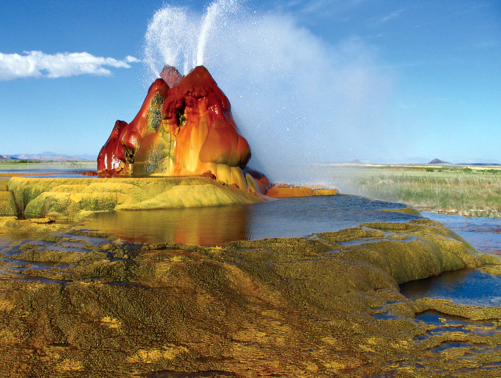
Fly Geyser, also known as Fly Ranch Geyser, is a small geothermal geyser located on private land in Washoe County, Nevada, about 20 miles (32 km) north of Gerlach. Fly Geyser is located near the edge of Fly Reservoir in the Hualapai Geothermal Flats and is approximately 5 feet (1.5 m) high by 12 feet (3.7 m) wide, counting the mound on which it sits.
Key Information


In June 2016, the non-profit Burning Man Project purchased the 3,800 acres (1,500 ha) Fly Ranch, including the geyser, for $6.5 million.[1][2] The Burning Man Project began offering limited public access to the property in May 2018.[3] The geyser contains thermophilic bacteria and archaea,[4] which flourish in moist, hot environments, resulting in multiple hues of green and red, coloring the rocks.
Location
[edit]Fly Geyser is located on the Fly Ranch in Hualapai Flat, about 0.3 miles (0.48 km) from State Route 34[5] and about 25 miles (40 km) north of Gerlach, Nevada. It is west of Black Rock Desert.
Origin
[edit]The source of the Fly Geyser field's heat is attributed to a very deep pool of hot rock where tectonic rifting and faulting are common.
The first geyser at the site was formed in 1916 when a well was drilled seeking irrigation water. When geothermal water at close to boiling point was found, the well was abandoned, and a 10–12-foot (3.0–3.7 m) calcium carbonate cone formed.[6]
In 1964, a geothermal energy company drilled a second well near the site of the first well.[6] The water was not hot enough for energy purposes. They reportedly capped the well, but the seal failed. The discharge from the second well released sufficient pressure that the original geyser dried up.[6][7] Dissolved minerals in the water, including calcium carbonate and silica, accumulated around the new geyser, creating the cones and travertine pools.[7]
The geyser has multiple conic openings sitting on a mound: the cones are about 6 feet (1.8 m), and the entire mound is 25 to 30 feet (7.6 to 9.1 m) tall.

Characteristics
[edit]The temperature of the water exiting the geyser can exceed 200 °F (93 °C),[10] which is typical for geysers at high elevation.[11]
Carolina Muñoz Saez, who was hired by the Burning Man owners to study the geyser, reported that the geyser contains "a really high amount of silica." The silica combined with the temperature has caused quartz to form inside the geyser extraordinarily quickly. Quartz typically takes up to 10,000 years to develop in geysers.[10] Saez said the Fly Geyser is unlike any other geyser she has studied.[10]
Water is constantly released, reaching 5 feet (1.5 m) in the air.[5] The geyser has formed several travertine terraces, creating 30 to 40 pools over an area of 74 acres (30 ha).[12] The water produced by the geyser contains thermophilic algae, which flourish in moist, hot environments, coloring the rocks with brilliant hues of green and red.[6][7]
Public access
[edit]Fly Ranch is open to small, guided three-hour nature walks from April to October of each year.[10] The geyser is part of the nature walk. Tours are managed and led by the Friends of Black Rock-High Rock.[13][14]
Payments for tickets for the walk are considered to be donations and are used to support Fly Ranch and the Friends organization.[13]
Other local geysers
[edit]A prior well-drilling attempt in 1917 resulted in the creation of a geyser close to the currently active Fly Geyser; it created a pillar of calcium carbonate about 12 feet (3.7 m) tall, but ceased when the Fly Geyser began releasing water in 1964.[7]
References
[edit]- ^ "Fly Ranch - Burning Man Project". burningman.org.
- ^ "We Bought Fly Ranch". Burning Man Journal. Retrieved 2017-11-08.
- ^ "Fly Ranch - Burning Man Project". Fly Ranch - Burning Man Project. Retrieved 2017-11-08.[dead link]
- ^ https://landartgenerator.org/lagi2020/FlyRanch-Microbial-Biogeochemistry.pdf, p. 17 and p. 20–23
- ^ a b "Fly Geyser". CmdrMark.com. Archived from the original on 2017-08-27. Retrieved 2010-06-01.
- ^ a b c d Fly Gerser
- ^ a b c d Richard Moreno (4 November 2008). Nevada Curiosities: Quirky Characters, Roadside Oddities & Other Offbeat Stuff. Globe Pequot Press. pp. 104–. ISBN 978-0-7627-4682-8. Retrieved 15 July 2013.[permanent dead link]
- ^ "Fly Geyser". Travels in the American Southwest. CmdrMark.com. 2003-08-23. Archived from the original on 2017-08-27. Retrieved 2014-11-08.
- ^ Leininger, Merrie. "Playa playground - indulge your primitive side at Northern Nevada's Black Rock Desert". Nevada Magazine. Archived from the original on 2011-07-14. Retrieved 2008-10-13.
- ^ a b c d Zee, Brenda (April 6, 2018) "Fly Geyser Opens To Public For First Time In Two Decades" KUNR
- ^ Rinehart, John S. (2012-12-06). Geysers and Geothermal Energy. Springer Science & Business Media. ISBN 978-1-4612-6084-4.
- ^ "Fly Geyser". FlyGeyser.org. Archived from the original on 2010-06-20. Retrieved 2010-06-01.
- ^ a b FLY GEYSER NEVADA TOUR – WHAT YOU NEED TO KNOW BEFORE YOU GO
- ^ "Fly Geyser". Archived from the original on 2021-03-05. Retrieved 2019-01-01.
External links
[edit]- Fly Geyser Archived 2019-04-17 at the Wayback Machine (in German)
- "Fly Geyser". Friends of Black Rock High Rock. Archived from the original on 2013-06-05. Retrieved 2010-09-07.
- "Fly Geyser Nevada". All Over the Map. Archived from the original on 2011-12-09. Retrieved 2010-09-07.
- Images and background of Fly Geyser
- Fly Ranch-Burning Man Project
Fly Geyser
View on GrokipediaGeography and Location
Site Coordinates and Elevation
Fly Geyser is precisely located at 40°51′34″N 119°19′55″W on the private Fly Ranch property in Washoe County, Nevada.[5] This positioning places it within the expansive Black Rock Desert, a remote high-desert expanse known for its geothermal features. The site's elevation stands at 4,014 feet (1,223 m) above sea level, contributing to the harsh, elevated conditions typical of the region.[6] Approximately 20 miles (32 km) north of the town of Gerlach, Nevada, Fly Geyser occupies a strategic spot along State Route 34, accessible only via guided tours due to its status on private land.[7] The immediate surroundings form an arid desert landscape dominated by alkaline flats and sparse vegetation, situated near the edge of Fly Reservoir in the Hualapai Geothermal Flats.[8] This terrain underscores the isolation and environmental extremity of the Black Rock Desert area, where extreme temperatures and low precipitation define the habitat.Regional Geological Context
Fly Geyser is situated within the Basin and Range Province of the western United States, a vast region characterized by extensional tectonics that has produced a landscape of alternating mountain ranges and fault-bounded valleys. Northwestern Nevada, where the geyser is located, exemplifies this province's fault-block terrain, with the Hualapai Flat serving as a key intermountain basin bounded by the Granite Range to the east and the Calico Hills to the north and west. This structural setting results from Cenozoic normal faulting, which has created grabens filled with thick Quaternary sediments, including over 2,000 feet (610 m) of lacustrine deposits from ancient Lake Lahontan.[9] The regional fault lines play a critical role in facilitating geothermal upwelling in the Hualapai Valley area. Major normal faults trend in three directions—northeast along the Black Rock Desert, northwest along the Granite Range, and north-south through Hualapai Flat and adjacent ranges—intersecting near the town of Gerlach. These intersections, combined with steps and terminations in the range-front faults, enhance permeability and channel heated fluids upward, as evidenced by Holocene fault scarps and recurrent tensional activity since the Late Tertiary. Late Quaternary faulting, with displacements exceeding 5,000 feet vertically in nearby grabens, maintains open fractures that serve as conduits for geothermal fluids.[9][10] Hydrologically, the area's hot springs, including those near Fly Geyser, are fed by groundwater recharged from precipitation and surface runoff in the surrounding ranges, which percolates through fractured basement rocks such as Permian-Triassic metavolcanics, Cretaceous granodiorite, and Tertiary volcanics before discharging at the surface. This groundwater is heated by the high regional heat flow characteristic of the Great Basin's Battle Mountain Heat Flow Province, where conductive heat transfer through thinned lithosphere—rather than shallow magma or recent volcanism—elevates subsurface temperatures to over 150°C in reservoirs. Thick insulating layers of clay-rich lacustrine sediments trap this heat, promoting upwelling at fault zones without associated volcanic activity.[9][11] In comparison to other geothermal features in Nevada, the Hualapai Flat's natural manifestations—such as the Gerlach and Fly Ranch hot springs clusters, with surface temperatures up to 94°C—are typical of Basin and Range systems driven by tectonic extension and fault-controlled circulation of meteoric waters. These differ from anthropogenic features like Fly Geyser, which resulted from drilling that pierced shallow aquifers and accelerated mineral deposition, though the underlying heat source remains the same regional geothermal gradient. Unlike volcanic-dominated systems elsewhere in the state, such as Steamboat Springs, the area's activity relies on non-magmatic heat flow, making it representative of Nevada's extensive low-enthalpy resources.[9][12]History and Formation
Early Development and Accidental Creation
The Fly Geyser originated from human activities in the early 20th century when, in 1916, local ranchers in the Hualapai Valley near Gerlach, Nevada, drilled a shallow well to access groundwater for irrigation purposes. The drilling unexpectedly tapped into a geothermal source, yielding water heated to approximately 200°F (93°C), which was unsuitable for agricultural use due to its high temperature and mineral content. The well was subsequently abandoned, but the persistent flow of hot, mineral-rich water led to the gradual deposition of calcium carbonate, forming a small travertine cone known as "The Wizard" that reached heights of 10–12 feet (3–3.7 m) over the following decades. This was one of three geysers on the property, including Fly Geyser and Will's Geyser.[3][8] In 1964, a geothermal exploration effort by Western Geothermal Partnership further altered the site when the company drilled a deeper temperature-gradient test well approximately 800 feet (244 m) into the subsurface to assess potential energy resources. This well penetrated a hot aquifer, indicative of lateral flow from deeper geothermal sources. However, the well's casing failed or was improperly sealed upon abandonment, allowing pressurized hot water to erupt uncontrollably and redirecting the geothermal flow, sharply reducing pressure at the original 1916 feature but not eliminating it.[3] The seal failure initiated continuous eruptions from the 1964 well, marking the birth of the modern Fly Geyser and triggering rapid cone formation through ongoing mineral precipitation beginning in the mid-1960s. The ejected water, saturated with dissolved silica and carbonates, evaporated quickly in the arid desert environment, depositing layers of travertine and siliceous sinter at rates that built significant structures within years; for instance, early growth observations noted cones expanding by 2–3 feet over 6–10 years in similar nearby features. Thermophilic algae in the outflow further accelerated deposition by facilitating mineral crystallization, contributing to the geyser's distinctive multicolored appearance.[3][13]Modern Ownership and Land Management
Following the accidental creation of the geyser in 1964 through geothermal drilling efforts, the Fly Ranch property, encompassing the site, remained under private ownership for over five decades. Various individuals and entities, including the John Casey estate until 1998 and subsequently the Bright Holland Corporation under Todd Jaksick, controlled the 3,800-acre land, strictly restricting public access to prevent trespassing and damage to the developing geothermal features.[14][15] In June 2016, the non-profit Burning Man Project acquired Fly Ranch for $6.5 million through direct donations, aiming to preserve it as a protected sanctuary rather than a commercial attraction. This purchase marked a shift toward long-term stewardship, with the organization committing to ecological restoration and limited public engagement while maintaining the site's seclusion from unrestricted visitation.[16][17] By 2018, the Burning Man Project entered a partnership with the Friends of Black Rock-High Rock, a conservation group, to co-manage public programs on the property, including guided nature walks that promote awareness of the site's geothermal and natural features without compromising its integrity. This collaboration has facilitated controlled access while prioritizing preservation.[18][19] As of 2025, ongoing conservation initiatives under Burning Man Project oversight include habitat restoration across the ranch, such as rehabilitating over 600 acres of wetlands, restoring waterways, and creating nesting and migration corridors for local wildlife, including 143 plant species and 136 bird species. These efforts also involve removing non-native species and managing excavated landfills to enhance biodiversity and sustainability on the land.[20][21]Physical Characteristics
Structure and Morphology
Fly Geyser is classified as a cone-type geyser, featuring multiple cone-like formations constructed primarily from travertine, a type of calcium carbonate deposit, along with siliceous sinter.[22] These formations create a distinctive morphology with several openings that resemble branching horns, formed through the accumulation of precipitated minerals from geothermal fluids.[2] The central cones measure approximately 6 feet (1.8 m) in height and 12 feet (3.7 m) in width, rising from a broader base.[23] Surrounding these cones is a larger mound that elevates the structure to 25–30 feet (7.6–9.1 m) in total height, shaped by ongoing mineral deposition.[2] The geyser complex spans about 74 acres, including 30–40 shallow pools formed from travertine terraces at the base, which collect and cool the outflowing water.[24] Visually, the structure displays vibrant multicolored patterns, with reds and greens primarily from thermophilic algae growing on the travertine surfaces and whites from the mineral deposits themselves, creating rainbow-like effects.[1][22]Geothermal Activity and Mineral Deposits
The Fly Geyser exhibits continuous geothermal activity characterized by a steady ejection of superheated water from multiple vents on its cone structure. This eruption occurs constantly, propelling water up to 5 feet (1.5 meters) in height, driven by the pressure from the underlying geothermal reservoir. The water temperature at the surface reaches approximately 93 °C (199 °F), reflecting the intense heat from the subsurface source.[25][26] The mineral deposits forming the geyser's cone are primarily composed of silica-rich materials, with high concentrations of dissolved silica in the geothermal water promoting rapid quartz crystallization. Unlike natural geysers, where quartz formation typically requires around 10,000 years under ambient conditions, the elevated temperatures and silica saturation at Fly Geyser accelerate this process, enabling quartz development within mere years or decades. This unusual rapidity is attributed to the supersaturated state of the water, which favors immediate precipitation of amorphous silica that transitions into crystalline quartz.[26][25] Deposition occurs through the cooling and evaporation of the ascending hot water, which carries dissolved minerals such as silica and calcium carbonate; upon exposure to air, these minerals precipitate out, building the cone at a rate of several inches per year. The water originates from a regional geothermal aquifer in the Hualapai Geothermal Flats, circulating through fault-related conduits at depths of approximately 300 meters (980 feet), with a chemistry featuring alkaline pH values between 7.8 and 8.4, hardness of 120 mg/L as CaCO₃, and alkalinity of 240 mg/L as CaCO₃, all supporting the sustained flow and mineral transport.[27][28][1]Ecology and Biology
Microbial Communities
The microbial communities inhabiting Fly Geyser consist primarily of thermophilic bacteria and cyanobacteria that endure the site's extreme conditions, including water temperatures up to 74°C at the outflow and alkaline pH levels of 7.8 to 8.4. These organisms, such as members of the Candidate Phylum Hydrothermae (comprising up to 14% of communities in nearby features), thrive in the mineral-saturated pools and outflow channels, forming layered microbial mats that serve as the primary biomass in this geothermal ecosystem.[27] These microbes play a key role in the geyser's striking coloration, with cyanobacteria producing green hues through photosynthetic pigments and coatings on the cone and pools, while thermophilic algae contribute red and other vibrant tones in the moist, hot environments.[27][1] Fly Geyser serves as an important model for extremophile research, offering insights into microbial adaptations in high-temperature, silica-rich settings analogous to early Earth or extraterrestrial environments like Mars, with potential applications in NASA's astrobiology studies. Silica-tolerant microbes in the pools interact with the geyser's high-silica waters to accelerate mineral deposition, such as calcium carbonate formations, influencing the feature's ongoing growth.[27][23] The diversity of these communities is notable, with over 16 phyla—including Cyanobacteria, Proteobacteria, Bacteroidetes, Aquificae, Actinobacteria, and Atribacteria—represented, encompassing more than 2,800 genera based on next-generation sequencing of over 1 million DNA reads from pool samples. This richness, with microbial mats supporting interdependent species in stratified layers, underscores the geyser's value for studying biogeochemical cycles in extreme habitats.[27]Surrounding Habitat and Biodiversity
The Fly Ranch, encompassing 3,800 acres in Nevada's Black Rock Desert region, features a high desert ecosystem characterized by sparse vegetation dominated by sagebrush-steppe habitats and alkali-adapted plants such as saltbrush and greasewood, which thrive in the arid, alkaline soils of the area.[29][8][30] This environment supports a diverse array of native flora, with ecological surveys documenting 144 plant species, including various wildflowers that bloom seasonally in the harsh conditions.[29] Efforts to manage 18 non-native species, such as cheatgrass, through rewilding and restoration projects help preserve the integrity of this desert landscape.[29] Wildlife in the surrounding habitat includes 15 mammal species adapted to arid conditions, such as coyotes, bobcats, mule deer, pronghorn antelope, and wild horses, alongside 138 bird species like eagles, hawks, and owls, and 12 reptile species.[29][31][32] These species utilize the ranch's varied terrain, from dry playas to intermittent streams, though populations remain low due to the overall aridity and lack of large predators beyond occasional mountain lions.[31] The geothermal features of Fly Geyser contribute to unique wetter microhabitats, including 600 acres of protected wetlands formed by hot and cold springs, which sustain insects and other small invertebrates in an otherwise dry ecosystem.[29][31] These areas enhance local biodiversity by providing moisture and mineral-rich environments that support food webs extending from microbial mats in the pools to higher trophic levels.[29] Since its purchase by the Burning Man Project in 2016, Fly Ranch has functioned as a sanctuary for native species, with comprehensive biodiversity surveys initiated in 2017 over 18 months documenting the full spectrum of flora and fauna, including five newly identified species through bioblitzes.[29][31] Conservation measures, such as habitat restoration along Cottonwood Creek and soil regeneration using compost, underscore the ranch's role in protecting this ecologically significant high desert area.[31]Access and Preservation
Guided Tours and Public Visitation
Public access to Fly Geyser commenced with guided tours in April 2018, enabling limited visitation to the site following its acquisition by the Burning Man Project in 2016.[33] These tours, known as Fly Ranch Nature Walks, operate from April through November on select Saturdays as of 2025, accommodating small groups of up to 20 participants for a 3-hour guided experience covering approximately 3 miles of uneven terrain.[4][34][35][36] Reservations are mandatory and available via the Friends of Black Rock-High Rock website at blackrockdesert.org, using the TicketLeap platform, with tickets ranging from $27 to $52 per adult including service fees as of 2025.[37][38][39][40] Unguided entry is strictly prohibited on the private 3,800-acre Fly Ranch property, where trespassing is not allowed to protect the fragile geothermal features and ecosystem.[41] Participants should prepare by booking well in advance due to high demand, dressing in layers and sturdy closed-toe shoes suitable for variable desert weather, carrying sufficient water, and adhering to tour guidelines that permit photography while emphasizing minimal environmental impact. Tours are ongoing as of November 2025.[38][40]Conservation Measures and Challenges
Since its acquisition in 2016, the Burning Man Project has led conservation initiatives at Fly Ranch in collaboration with the Friends of Black Rock-High Rock, focusing on habitat restoration through annual Restoration Weekends that involve community volunteers in revegetation and wetland rehabilitation efforts across the site's 600 acres of springs and pools.[42][43][19] Trail maintenance is conducted regularly by stewards to prevent soil compaction and erosion, including the installation of durable pathways and signage to guide foot traffic away from sensitive geothermal areas.[20] Scientific monitoring, spearheaded by the Burning Man Land Fellow program, includes ongoing ecological surveys of microbial life, endangered species like the Fly Ranch springsnail, and geothermal dynamics, with data collection supporting rewilding projects and compliance reporting.[35][31] Key challenges to preservation include erosion caused by foot traffic, which can destabilize the travertine formations around Fly Geyser; the risk of over-visitation straining the fragile wetland ecosystem; and climate change effects, such as aridification leading to visible reductions in surface and groundwater levels that threaten the site's hot springs and biodiversity.[31][44] These issues are mitigated through restricted access protocols, but external pressures like potential groundwater extraction from nearby basins exacerbate water scarcity concerns.[31] Fly Ranch is designated as a private preserve under the ownership of the nonprofit Burning Man Project, granting it protections against unregulated development while requiring adherence to Nevada's environmental regulations, including those governing geothermal resources under Nevada Revised Statutes Chapter 534A, which affirm private ownership rights to subsurface heat and associated waters subject to permitting for extraction or use.[31][45] Zoning as General Rural in Washoe County further supports conservation by permitting low-impact activities like recreation and renewable energy without mandating industrial exploitation.[31] As of 2025, future plans emphasize expanded research partnerships, including collaborations with institutions like the University of Nevada, Reno for geological and biological studies, and sustainable tourism objectives aligned with the Burning Man Project's 2030 Sustainability Roadmap, which prioritize regenerative infrastructure and cap public access through guided tours to maintain visitor numbers at sustainable levels.[46][47][31] These efforts aim to prototype net-zero systems for energy, water, and waste while fostering community-driven ecological resilience.[31]Related Geothermal Features
Other Geysers on Fly Ranch
Fly Ranch encompasses multiple geothermal features beyond the prominent Fly Geyser, all sustained by a shared subsurface aquifer system that drives the region's hydrothermal activity. These include both artificial and natural manifestations of geothermal energy, contributing to a diverse array of mineral deposits and ecosystems on the 3,800-acre property. The earliest known geyser on the ranch, referred to as The Wizard, originated from a 1916 well-drilling attempt aimed at irrigation in the arid Hualapai Valley. This effort inadvertently tapped into geothermal fluids, forming an active geyser that built a 12-foot (3.7 m) tall pillar of calcium carbonate through mineral precipitation; the feature became inactive, possibly influenced by subsequent drilling activities in the area that redirected subsurface flows.[8][9][1] A second notable feature is Will's Geyser, a smaller, intermittently erupting geyser discovered in 2006 and believed to be of natural origin, which displays red hues from iron-rich mineral deposits and supports thermophilic microorganisms akin to those in Fly Geyser. This geyser erupts less vigorously than Fly Geyser but adds to the site's colorful geothermal landscape. Together with the artificial Fly Geyser and The Wizard, Will's Geyser forms the ranch's trio of geysers.[48][15][8] Complementing these are numerous unnamed hot spring pools scattered across the property, which have precipitated 30–40 travertine formations through ongoing calcium carbonate deposition. These pools vary in temperature and flow, ranging up to 219°F (104°C) at the surface, and collectively highlight the ranch's extensive geothermal potential.[15][11] All these elements interconnect via the common aquifer, where Fly Geyser represents the most dynamic and continuous expression of the underlying hydrothermal system. The microbial communities in these features, including thermophilic bacteria and archaea, exhibit similarities that underscore their shared environmental conditions.[9]Nearby Geothermal Sites in Nevada
Fly Geyser is situated in the expansive Black Rock Desert region of northern Nevada, where it shares proximity with several natural hot springs, including those at Soldier Meadows, located approximately 40 miles to the north. These hot springs emerge from the desert landscape, offering soaking pools maintained by the Bureau of Land Management and attracting visitors seeking remote geothermal experiences. Unlike the accidental man-made formation of Fly Geyser from a 1964 well-drilling mishap, the Soldier Meadows springs are entirely natural, fed by underground aquifers heated by geothermal activity in the area.[49][1] In broader comparisons across Nevada, Fly Geyser stands out as a rare man-made geothermal feature amid predominantly natural sites, such as the Steamboat Springs geothermal field near Reno, which spans a much larger area and historically hosted over 20 active geysers erupting up to 80 feet high before activity largely ceased in the mid-1980s due to resource development. Steamboat, now a site for geothermal power generation and therapeutic hot spring resorts, exemplifies Nevada's extensive natural geothermal systems, contrasting with Fly Geyser's localized, vividly colored mineral cone formed by continuous mineral deposition. Recent minor geyser resurgence at Steamboat in 2024 highlights ongoing hydrothermal dynamics in the region, underscoring the variability between natural fields like Steamboat and the engineered origins of Fly Geyser.[50] Nevada hosts over 300 documented hot springs, making it the state with the highest concentration in the United States, many of which, including those near Fly Geyser, are linked to the Basin and Range Province's extensional tectonics that fracture the crust and facilitate upward migration of heated groundwater. These geological similarities to the regional context—characterized by normal faulting and thinned crust—provide the structural pathways for geothermal fluids across the Great Basin. For visitors, Fly Geyser integrates into Nevada's emerging geothermal tourism trail, complementing accessible sites like Steamboat's resorts and remote soaks at Soldier Meadows to form a network of attractions that highlight the state's volcanic and tectonic heritage.[51][11][52]References
- https://wiki.blackrockdesert.org/wiki/Fly_Geyser