
Recent from talks
Gaya Island
Knowledge base stats:
Talk channels stats:
Members stats:
Gaya Island
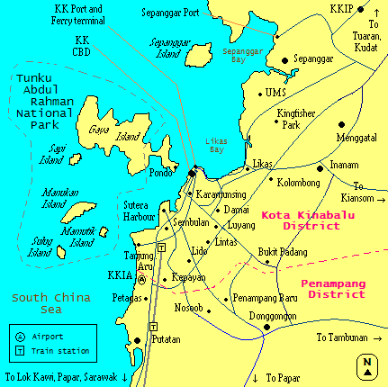
Gaya Island (Malay: Pulau Gaya; Kadazan Dusun: Gayo; West Coast Bajau: Goyoh) is a sizeable island located in the West Coast Division of Kota Kinabalu District, Sabah in the South China Sea in Malaysia. With a size of 1,483 hectares (3,665 acres), the island forms part of the Tunku Abdul Rahman Park (TARP) with an elevation of up to 300 metres (980 ft). Several ridges rise more than 180 metres (590 ft), peaking at 300 metres (980 ft), along the backbone of the island.
Historically, Gaya Island was the settlement harbour of the British North Borneo Chartered Company (NBCC). Faced with various problems with the lack of streams and rivers, infertile soils, and the island position sheltered from winds, Gaya did not flourish as expected and was further razed to the ground by local resistance leader Mat Salleh during a rebellion on 9 July 1897 and never thereafter rebuilt. It has been gazetted as a forest reserve since 1923, during the administration of British North Borneo. In 1974, the TARP became Sabah's second national park gazetted after the Kinabalu Park. Gaya is the largest island gazetted within the TARP, is closest to the state capital and is covered with dense virgin tropical forest.
The island has 20 kilometres (12 mi) of hiking trails and three five-star resorts named Gayana Marine Resort, home to the Marine Ecology Research Centre; the neighbouring Gaya Island Resort (by YTL Hotel Group); and the Bunga Raya Island Resort on the northeast part of the island. The island is known as a paradise for snorkellers, and divers while also offering paddleboarding, zip lining and guided treks on its lush forests. In the 2010s, there has been a plan to turn Gaya Island into a city island and tourism hub. A cable car line has also been proposed before to connect with the city centre. In 2024, the island has an estimated population of 30,000, with only 1,000 belonging to the original island inhabitants, while the rest were illegal immigrants arriving in the 1970s.
Gaya Island derived its name from the word "gayo", which means "big" in the Kadazan-Dusun, as well as "goyoh" in the Bajau languages. According to J. H. Macartney, a former local British Secretary for the Local Government in North Borneo, the name "gaya" comes from the local Bajau word "goyoh", which is translated as "big" in English. Therefore, Gaya Island literally translates as "Big Island" by the British. The island soil is described as bright red clay.
As with most islands in northern Borneo, Gaya Island was once under the thalassocracy of the Sultanate of Brunei. In 1765, British navigator Thomas Forrest, serving under the East India Company (EIC), made a survey on the island. On 29 December 1877, Sultan Abdul Momin of Brunei made a cession and conferred the title of "Maharaja of Gaya and Sandakan" to German adventurer, businessman and diplomat Baron von Overbeck, and the following year, on 22 January 1878, Sultan Jamal ul-Azam of Sulu also made a cession and conferred the title of "Dato Bendahara and Raja of Sandakan" to him. This resulted in Overbeck having the authority over the area in northern Borneo, from Kimanis to Sibuku Bay, as well as islands such as Gaya Island, Ambong Island and Marudu. When Overbeck left, all rights were passed into British colonial merchant and entrepreneur Alfred Dent, who later formed the North Borneo Chartered Company (NBCC).
The foundation of Gaya Island as an early trading settlement is associated with the foundation of the town of Jesselton. Before the Europeans' arrival, the island was inhabited by the local Bajau people. In 1882, the NBCC set up an early British trading settlement on the island with the focus on the development of infrastructure for it to become the central administration of North Borneo as well as the collection site for raw materials gathered from the western coast. Therefore, NBCC provided various infrastructure facilities such as administrative buildings, jetty warehouses, rows of shops and housing areas based on non-permanent materials such as nibong (oncosperma tigillarium) and rumbia (metroxylon sagu) roofs. Based on the book of "Exploration of Mount Kina Balu, North Borneo" by English explorer and naturalist John Whitehead in 1893, he summarised the condition of the island infrastructure as follows:
Gaya Island on 9 April 1885 had several Chinese shops built in a row facing the sea on a flat area of several acres, but the resident of Gaya Island at that time felt that the 'Town Lot' on the island would not achieve progress because a year later when the island was revisited, it was found that the shops, houses and administrative buildings were in a dilapidated condition and no longer suitable for use since the structure were only made based on ordinary materials found on the island.
The NBCC settlement on the island did not last longer than expected as a result of various problems such as extremely hot temperatures, shallow waters, difficulty in obtaining clean water resources and destruction caused by Mat Salleh's rebellion in 1897. This situation caused the British to start looking for a new settlement area to replace the island's role as the administrative centre and port for the western coast of North Borneo. As a result, Gantian was deemed a suitable location but due to its mangrove swamps that made it difficult to build a railway system and difficult shipping routes with declining trade, mainland Jesselton was founded in 1899 as the most suitable replacement of Gaya Island, named in honour of Charles Jessel, a manager of the NBCC.
Hub AI
Gaya Island AI simulator
(@Gaya Island_simulator)
Gaya Island
Gaya Island (Malay: Pulau Gaya; Kadazan Dusun: Gayo; West Coast Bajau: Goyoh) is a sizeable island located in the West Coast Division of Kota Kinabalu District, Sabah in the South China Sea in Malaysia. With a size of 1,483 hectares (3,665 acres), the island forms part of the Tunku Abdul Rahman Park (TARP) with an elevation of up to 300 metres (980 ft). Several ridges rise more than 180 metres (590 ft), peaking at 300 metres (980 ft), along the backbone of the island.
Historically, Gaya Island was the settlement harbour of the British North Borneo Chartered Company (NBCC). Faced with various problems with the lack of streams and rivers, infertile soils, and the island position sheltered from winds, Gaya did not flourish as expected and was further razed to the ground by local resistance leader Mat Salleh during a rebellion on 9 July 1897 and never thereafter rebuilt. It has been gazetted as a forest reserve since 1923, during the administration of British North Borneo. In 1974, the TARP became Sabah's second national park gazetted after the Kinabalu Park. Gaya is the largest island gazetted within the TARP, is closest to the state capital and is covered with dense virgin tropical forest.
The island has 20 kilometres (12 mi) of hiking trails and three five-star resorts named Gayana Marine Resort, home to the Marine Ecology Research Centre; the neighbouring Gaya Island Resort (by YTL Hotel Group); and the Bunga Raya Island Resort on the northeast part of the island. The island is known as a paradise for snorkellers, and divers while also offering paddleboarding, zip lining and guided treks on its lush forests. In the 2010s, there has been a plan to turn Gaya Island into a city island and tourism hub. A cable car line has also been proposed before to connect with the city centre. In 2024, the island has an estimated population of 30,000, with only 1,000 belonging to the original island inhabitants, while the rest were illegal immigrants arriving in the 1970s.
Gaya Island derived its name from the word "gayo", which means "big" in the Kadazan-Dusun, as well as "goyoh" in the Bajau languages. According to J. H. Macartney, a former local British Secretary for the Local Government in North Borneo, the name "gaya" comes from the local Bajau word "goyoh", which is translated as "big" in English. Therefore, Gaya Island literally translates as "Big Island" by the British. The island soil is described as bright red clay.
As with most islands in northern Borneo, Gaya Island was once under the thalassocracy of the Sultanate of Brunei. In 1765, British navigator Thomas Forrest, serving under the East India Company (EIC), made a survey on the island. On 29 December 1877, Sultan Abdul Momin of Brunei made a cession and conferred the title of "Maharaja of Gaya and Sandakan" to German adventurer, businessman and diplomat Baron von Overbeck, and the following year, on 22 January 1878, Sultan Jamal ul-Azam of Sulu also made a cession and conferred the title of "Dato Bendahara and Raja of Sandakan" to him. This resulted in Overbeck having the authority over the area in northern Borneo, from Kimanis to Sibuku Bay, as well as islands such as Gaya Island, Ambong Island and Marudu. When Overbeck left, all rights were passed into British colonial merchant and entrepreneur Alfred Dent, who later formed the North Borneo Chartered Company (NBCC).
The foundation of Gaya Island as an early trading settlement is associated with the foundation of the town of Jesselton. Before the Europeans' arrival, the island was inhabited by the local Bajau people. In 1882, the NBCC set up an early British trading settlement on the island with the focus on the development of infrastructure for it to become the central administration of North Borneo as well as the collection site for raw materials gathered from the western coast. Therefore, NBCC provided various infrastructure facilities such as administrative buildings, jetty warehouses, rows of shops and housing areas based on non-permanent materials such as nibong (oncosperma tigillarium) and rumbia (metroxylon sagu) roofs. Based on the book of "Exploration of Mount Kina Balu, North Borneo" by English explorer and naturalist John Whitehead in 1893, he summarised the condition of the island infrastructure as follows:
Gaya Island on 9 April 1885 had several Chinese shops built in a row facing the sea on a flat area of several acres, but the resident of Gaya Island at that time felt that the 'Town Lot' on the island would not achieve progress because a year later when the island was revisited, it was found that the shops, houses and administrative buildings were in a dilapidated condition and no longer suitable for use since the structure were only made based on ordinary materials found on the island.
The NBCC settlement on the island did not last longer than expected as a result of various problems such as extremely hot temperatures, shallow waters, difficulty in obtaining clean water resources and destruction caused by Mat Salleh's rebellion in 1897. This situation caused the British to start looking for a new settlement area to replace the island's role as the administrative centre and port for the western coast of North Borneo. As a result, Gantian was deemed a suitable location but due to its mangrove swamps that made it difficult to build a railway system and difficult shipping routes with declining trade, mainland Jesselton was founded in 1899 as the most suitable replacement of Gaya Island, named in honour of Charles Jessel, a manager of the NBCC.
Recent media