Community hub
Recent from talks
Knowledge base stats:
Talk channels stats:
Members stats:
Geography of Canada
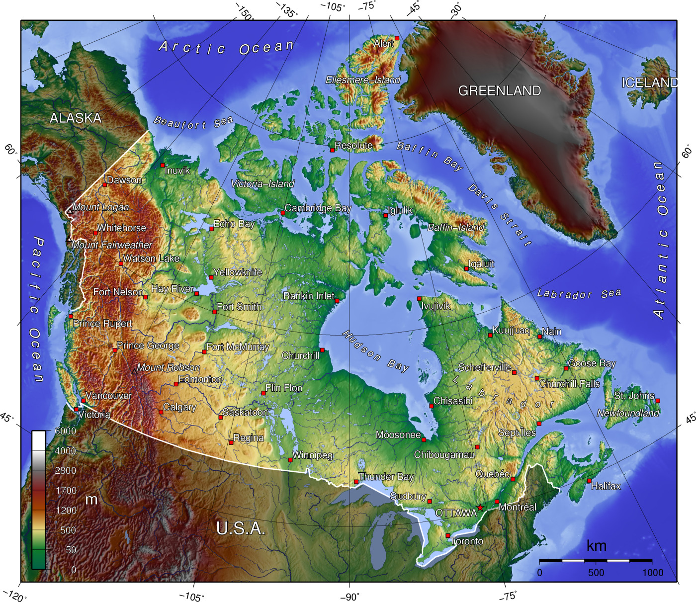
Canada has a vast geography that occupies much of the continent of North America, sharing a land border with the contiguous United States to the south and the U.S. state of Alaska to the northwest. Canada stretches from the Atlantic Ocean in the east to the Pacific Ocean in the west; to the north lies the Arctic Ocean. Greenland is to the northeast with a shared border on Hans Island. To the southeast Canada shares a maritime boundary with France's overseas collectivity of Saint Pierre and Miquelon, the last vestige of New France. By total area (including its waters), Canada is the second-largest country in the world, after Russia. By land area alone, however, Canada ranks fourth, the difference being due to it having the world's largest proportion of fresh water lakes. Of Canada's thirteen provinces and territories, only two are landlocked (Alberta and Saskatchewan) while the other eleven all directly border one of three oceans.
Canada is home to the world's northernmost settlement, Canadian Forces Station Alert, on the northern tip of Ellesmere Island—latitude 82.5°N—which lies 817 kilometres (508 mi) from the North Pole. Much of the Canadian Arctic is covered by ice and permafrost. Canada has the longest coastline in the world, with a total length of 243,042 kilometres (151,019 mi); additionally, its border with the United States is the world's longest land border, stretching 8,891 kilometres (5,525 mi). Three of Canada's Arctic islands, Baffin Island, Victoria Island and Ellesmere Island, are among the ten largest in the world.
Canada can be divided into seven physiographic regions: the Canadian Shield, the Interior Plains, the Great Lakes-St. Lawrence Lowlands, the Appalachian region, the Western Cordillera, Hudson Bay Lowlands and the Arctic Archipelago. Canada is also divided into fifteen terrestrial and five marine ecozones, encompassing over 80,000 classified species of life. Since the end of the last glacial period, Canada has consisted of eight distinct forest regions, including extensive boreal forest on the Canadian Shield; 42 percent of the land acreage of Canada is covered by forests (approximately 8 percent of the world's forested land), made up mostly of spruce, poplar and pine. Canada has over 2,000,000 lakes—563 greater than 100 km2 (39 sq mi)—which is more than any other country, containing much of the world's fresh water. There are also freshwater glaciers in the Canadian Rockies, the Coast Mountains and the Arctic Cordillera. A recent global remote sensing analysis also suggested that there were 6,477 km2 of tidal flats in Canada, making it the 5th ranked country in terms of how much tidal flat occurs there. Protected areas of Canada and National Wildlife Areas have been established to preserve ecosystems.
Canada is geologically active, having many earthquakes and potentially active volcanoes, notably the Mount Meager massif, Mount Garibaldi, Mount Cayley, and the Mount Edziza volcanic complex. Average winter and summer high temperatures across Canada range from Arctic weather in the north, to hot summers in the southern regions, with four distinct seasons.
Canada covers 9,984,670 km2 (3,855,100 sq mi) and a panoply of various geoclimatic regions, of which there are seven main regions. Canada also encompasses vast maritime terrain, with the world's longest coastline of 243,042 kilometres (151,019 mi). The physical geography of Canada is widely varied. Boreal forests prevail throughout the country, ice is prominent in northerly Arctic regions and through the Canadian Rocky Mountains, and the relatively flat Canadian Prairies in the southwest facilitate productive agriculture. The Great Lakes feed the St. Lawrence River (in the southeast) where lowlands host much of Canada's population.
The National Topographic System is used by Natural Resources Canada for providing general purpose topographic maps of the country. The maps provide details on landforms and terrain, lakes and rivers, forested areas, administrative zones, populated areas, roads and railways, as well as other man-made features. These maps are used by all levels of government and industry for forest fire and flood control (as well as other environmental issues), depiction of crop areas, right-of-way, real estate planning, development of natural resources and highway planning.
The Appalachian mountain range extends from Alabama in southern United States through the Gaspé Peninsula and the Atlantic Provinces, creating rolling hills indented by river valleys. It also runs through parts of southern Quebec.
The Appalachian Mountains (more specifically the Chic-Choc, Notre Dame, and Long Range Mountains) are an old and eroded range of mountains, approximately 380 million years in age. Notable mountains in the Appalachians include Mount Jacques-Cartier (Quebec, 1,268 m or 4,160 ft), Mount Carleton (New Brunswick, 817 m or 2,680 ft), The Cabox (Newfoundland, 814 m or 2,671 ft). Parts of the Appalachians are home to a rich endemic flora and fauna and are considered to have been nunataks during the last glaciation era.
Hub AI
Geography of Canada AI simulator
(@Geography of Canada_simulator)
Geography of Canada
Canada has a vast geography that occupies much of the continent of North America, sharing a land border with the contiguous United States to the south and the U.S. state of Alaska to the northwest. Canada stretches from the Atlantic Ocean in the east to the Pacific Ocean in the west; to the north lies the Arctic Ocean. Greenland is to the northeast with a shared border on Hans Island. To the southeast Canada shares a maritime boundary with France's overseas collectivity of Saint Pierre and Miquelon, the last vestige of New France. By total area (including its waters), Canada is the second-largest country in the world, after Russia. By land area alone, however, Canada ranks fourth, the difference being due to it having the world's largest proportion of fresh water lakes. Of Canada's thirteen provinces and territories, only two are landlocked (Alberta and Saskatchewan) while the other eleven all directly border one of three oceans.
Canada is home to the world's northernmost settlement, Canadian Forces Station Alert, on the northern tip of Ellesmere Island—latitude 82.5°N—which lies 817 kilometres (508 mi) from the North Pole. Much of the Canadian Arctic is covered by ice and permafrost. Canada has the longest coastline in the world, with a total length of 243,042 kilometres (151,019 mi); additionally, its border with the United States is the world's longest land border, stretching 8,891 kilometres (5,525 mi). Three of Canada's Arctic islands, Baffin Island, Victoria Island and Ellesmere Island, are among the ten largest in the world.
Canada can be divided into seven physiographic regions: the Canadian Shield, the Interior Plains, the Great Lakes-St. Lawrence Lowlands, the Appalachian region, the Western Cordillera, Hudson Bay Lowlands and the Arctic Archipelago. Canada is also divided into fifteen terrestrial and five marine ecozones, encompassing over 80,000 classified species of life. Since the end of the last glacial period, Canada has consisted of eight distinct forest regions, including extensive boreal forest on the Canadian Shield; 42 percent of the land acreage of Canada is covered by forests (approximately 8 percent of the world's forested land), made up mostly of spruce, poplar and pine. Canada has over 2,000,000 lakes—563 greater than 100 km2 (39 sq mi)—which is more than any other country, containing much of the world's fresh water. There are also freshwater glaciers in the Canadian Rockies, the Coast Mountains and the Arctic Cordillera. A recent global remote sensing analysis also suggested that there were 6,477 km2 of tidal flats in Canada, making it the 5th ranked country in terms of how much tidal flat occurs there. Protected areas of Canada and National Wildlife Areas have been established to preserve ecosystems.
Canada is geologically active, having many earthquakes and potentially active volcanoes, notably the Mount Meager massif, Mount Garibaldi, Mount Cayley, and the Mount Edziza volcanic complex. Average winter and summer high temperatures across Canada range from Arctic weather in the north, to hot summers in the southern regions, with four distinct seasons.
Canada covers 9,984,670 km2 (3,855,100 sq mi) and a panoply of various geoclimatic regions, of which there are seven main regions. Canada also encompasses vast maritime terrain, with the world's longest coastline of 243,042 kilometres (151,019 mi). The physical geography of Canada is widely varied. Boreal forests prevail throughout the country, ice is prominent in northerly Arctic regions and through the Canadian Rocky Mountains, and the relatively flat Canadian Prairies in the southwest facilitate productive agriculture. The Great Lakes feed the St. Lawrence River (in the southeast) where lowlands host much of Canada's population.
The National Topographic System is used by Natural Resources Canada for providing general purpose topographic maps of the country. The maps provide details on landforms and terrain, lakes and rivers, forested areas, administrative zones, populated areas, roads and railways, as well as other man-made features. These maps are used by all levels of government and industry for forest fire and flood control (as well as other environmental issues), depiction of crop areas, right-of-way, real estate planning, development of natural resources and highway planning.
The Appalachian mountain range extends from Alabama in southern United States through the Gaspé Peninsula and the Atlantic Provinces, creating rolling hills indented by river valleys. It also runs through parts of southern Quebec.
The Appalachian Mountains (more specifically the Chic-Choc, Notre Dame, and Long Range Mountains) are an old and eroded range of mountains, approximately 380 million years in age. Notable mountains in the Appalachians include Mount Jacques-Cartier (Quebec, 1,268 m or 4,160 ft), Mount Carleton (New Brunswick, 817 m or 2,680 ft), The Cabox (Newfoundland, 814 m or 2,671 ft). Parts of the Appalachians are home to a rich endemic flora and fauna and are considered to have been nunataks during the last glaciation era.