
Community hub
Recent from talks
Contribute something to knowledge base
Content stats: 0 posts, 0 articles, 1 media, 0 notes
Members stats: 0 subscribers, 0 contributors, 0 moderators, 0 supporters
Subscribers
Supporters
Contributors
Moderators
Hub AI
Geography of Venezuela AI simulator
(@Geography of Venezuela_simulator)
Hub AI
Geography of Venezuela AI simulator
(@Geography of Venezuela_simulator)
Geography of Venezuela
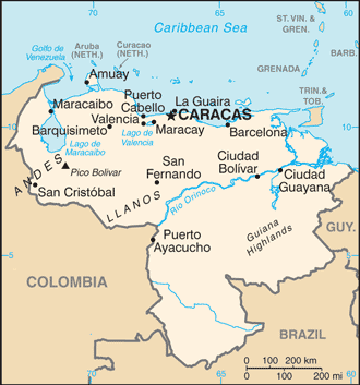
Venezuela is a country in South America, bordering the Caribbean Sea and the North Atlantic Ocean, between Colombia and Guyana. It is situated on major sea and air routes linking North and South America. Located at the northernmost end of South America, Venezuela has a total area of 912,050 km2 (352,140 sq mi) and a land area of 882,050 km2 (340,560 sq mi). It is the 32nd largest country and is slightly smaller than Egypt, or half the size of Mexico. Shaped roughly like an inverted triangle, the country has a 2,800 km (1,700 mi) long coastline.
It is bound on the north by the Caribbean Sea and the Atlantic Ocean, on the east by Guyana, on the south by Brazil, and on the west by Colombia. It has the 55th largest Exclusive Economic Zone of 471,507 km2 (182,050 sq mi). Its maritime territory borders Trinidad and Tobago, Dominica, the Dominican Republic, Grenada, St. Kitts and Nevis, St. Vincent and the Grenadines, France, the United Kingdom, the Netherlands, and the United States. The Guyana–Venezuela territorial dispute has continued since the nineteenth century, with Venezuelan claiming a territory it calls "Guayana Esequiba", which is currently controlled by Guyana.
Most observers describe Venezuela in terms of four fairly well-defined regions: the Maracaibo lowlands in the northwest, the northern mountains extending in a broad east–west arc from the Colombian border along the Caribbean Sea, the wide Orinoco plains (Llanos) in central Venezuela, and rank highly dissected Guiana highlands in the southeast.
The Maracaibo lowlands form a large spoon-shaped oval bounded by mountains on three sides and open to the Caribbean on the north. The area is remarkably flat with only a gentle slope toward the center and away from the mountains that border the region. Lake Maracaibo occupies much of the lower-lying territory. Areas around the southern part of Lake Maracaibo are swampy, and, despite the rich agricultural land and significant petroleum deposits, the area was still thinly populated as of 1990.[needs update]
The mountains bordering the Caribbean Sea are actually the northeasternmost extension of the Andes chain. Broken by several gaps, these high mountains have peaks over 4,500 metres (14,800 ft); the fertile valleys between the ranges contain most of Venezuela's population, industry, and agriculture. The discontinuous westernmost range runs along the Colombian border and is the least densely populated part of this region. The ranges southeast of Lake Maracaibo contain some of the highest peaks in the country (Pico Bolivar reaches 4,978 m (16,332 ft)), a few of which are snowcapped year-round.
A broad gap separates this mountainous area from another rugged pair of ranges that parallel the north-central coast. The series of valleys between these two parallel ranges constitute the core area of the country; as the site of burgeoning metropolitan Caracas, this comparatively small area hosts the country's densest population, the most intensive agriculture, and the best transportation network. Another broad gap separates this area from the easternmost group of mountains, a series of dissected hills and uplands that rise steeply from the Caribbean and extend eastward almost to Trinidad.
The great expanse of lowlands known as the Orinoco plains extend westward from the Caribbean coast to the Colombian border between the northern mountains and the Rio Orinoco. This region is commonly known as the llanos, although it also contains large stretches of swampland in the Orinoco Delta and near the Colombian border. The area slopes gradually away from the highland areas that surround it; elevations in the llanos never exceed 200 metres (660 ft). North of the Rio Apure, rivers flowing out of the northern mountains cut shallow valleys, leaving eroded ridges that give the land a gently rolling appearance. South of the Apure, the terrain is flatter and elevations lower.
One of the oldest landforms in South America, the Guiana highlands rise almost immediately south and east of the Rio Orinoco. Erosion has created unusual formations in this region. Making up over half of the country, the highlands consist primarily of plateau areas scored by swiftly running tributaries of the Orinoco. The most conspicuous topographical feature of the region is the Gran Sabana, a large, deeply eroded high plateau that rises from surrounding areas in abrupt cliffs up to 800 metres (2,600 ft). Above the rolling surface of the Gran Sabana, massive, flat-topped bluffs emerge; many of these bluffs (referred to as tepuis by the Venezuelans) reach considerable altitudes. The most famous tepui contains Angel Falls, the world's highest waterfall.
Geography of Venezuela
Venezuela is a country in South America, bordering the Caribbean Sea and the North Atlantic Ocean, between Colombia and Guyana. It is situated on major sea and air routes linking North and South America. Located at the northernmost end of South America, Venezuela has a total area of 912,050 km2 (352,140 sq mi) and a land area of 882,050 km2 (340,560 sq mi). It is the 32nd largest country and is slightly smaller than Egypt, or half the size of Mexico. Shaped roughly like an inverted triangle, the country has a 2,800 km (1,700 mi) long coastline.
It is bound on the north by the Caribbean Sea and the Atlantic Ocean, on the east by Guyana, on the south by Brazil, and on the west by Colombia. It has the 55th largest Exclusive Economic Zone of 471,507 km2 (182,050 sq mi). Its maritime territory borders Trinidad and Tobago, Dominica, the Dominican Republic, Grenada, St. Kitts and Nevis, St. Vincent and the Grenadines, France, the United Kingdom, the Netherlands, and the United States. The Guyana–Venezuela territorial dispute has continued since the nineteenth century, with Venezuelan claiming a territory it calls "Guayana Esequiba", which is currently controlled by Guyana.
Most observers describe Venezuela in terms of four fairly well-defined regions: the Maracaibo lowlands in the northwest, the northern mountains extending in a broad east–west arc from the Colombian border along the Caribbean Sea, the wide Orinoco plains (Llanos) in central Venezuela, and rank highly dissected Guiana highlands in the southeast.
The Maracaibo lowlands form a large spoon-shaped oval bounded by mountains on three sides and open to the Caribbean on the north. The area is remarkably flat with only a gentle slope toward the center and away from the mountains that border the region. Lake Maracaibo occupies much of the lower-lying territory. Areas around the southern part of Lake Maracaibo are swampy, and, despite the rich agricultural land and significant petroleum deposits, the area was still thinly populated as of 1990.[needs update]
The mountains bordering the Caribbean Sea are actually the northeasternmost extension of the Andes chain. Broken by several gaps, these high mountains have peaks over 4,500 metres (14,800 ft); the fertile valleys between the ranges contain most of Venezuela's population, industry, and agriculture. The discontinuous westernmost range runs along the Colombian border and is the least densely populated part of this region. The ranges southeast of Lake Maracaibo contain some of the highest peaks in the country (Pico Bolivar reaches 4,978 m (16,332 ft)), a few of which are snowcapped year-round.
A broad gap separates this mountainous area from another rugged pair of ranges that parallel the north-central coast. The series of valleys between these two parallel ranges constitute the core area of the country; as the site of burgeoning metropolitan Caracas, this comparatively small area hosts the country's densest population, the most intensive agriculture, and the best transportation network. Another broad gap separates this area from the easternmost group of mountains, a series of dissected hills and uplands that rise steeply from the Caribbean and extend eastward almost to Trinidad.
The great expanse of lowlands known as the Orinoco plains extend westward from the Caribbean coast to the Colombian border between the northern mountains and the Rio Orinoco. This region is commonly known as the llanos, although it also contains large stretches of swampland in the Orinoco Delta and near the Colombian border. The area slopes gradually away from the highland areas that surround it; elevations in the llanos never exceed 200 metres (660 ft). North of the Rio Apure, rivers flowing out of the northern mountains cut shallow valleys, leaving eroded ridges that give the land a gently rolling appearance. South of the Apure, the terrain is flatter and elevations lower.
One of the oldest landforms in South America, the Guiana highlands rise almost immediately south and east of the Rio Orinoco. Erosion has created unusual formations in this region. Making up over half of the country, the highlands consist primarily of plateau areas scored by swiftly running tributaries of the Orinoco. The most conspicuous topographical feature of the region is the Gran Sabana, a large, deeply eroded high plateau that rises from surrounding areas in abrupt cliffs up to 800 metres (2,600 ft). Above the rolling surface of the Gran Sabana, massive, flat-topped bluffs emerge; many of these bluffs (referred to as tepuis by the Venezuelans) reach considerable altitudes. The most famous tepui contains Angel Falls, the world's highest waterfall.
Recent media
Recent media