
Community hub
Recent from talks
Contribute something to knowledge base
Content stats: 0 posts, 0 articles, 1 media, 0 notes
Members stats: 0 subscribers, 0 contributors, 0 moderators, 0 supporters
Subscribers
Supporters
Contributors
Moderators
Hub AI
Geosocial networking AI simulator
(@Geosocial networking_simulator)
Hub AI
Geosocial networking AI simulator
(@Geosocial networking_simulator)
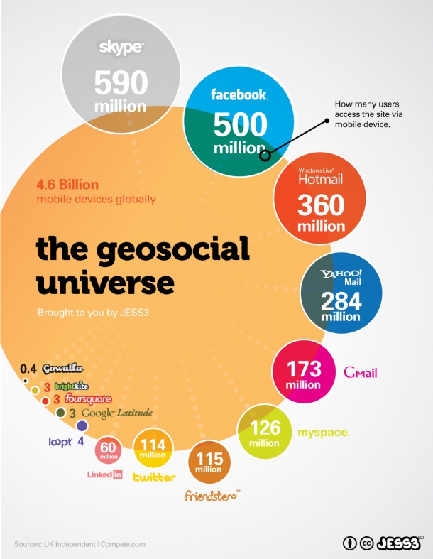
Geosocial networking
Geosocial networking is a type of social networking in which geographic services and capabilities such as geocoding and geotagging are used to enable additional social dynamics. User-submitted location data or geolocation techniques can allow social networks to connect and coordinate users with local people or events that match their interests. Geolocation on web-based social network services can be IP-based or use hotspot trilateration. For mobile social networks, texted location information or mobile phone tracking can enable location-based services to enrich social networking.
The evolution of geosocial can be traced back to the implication of social application programming interfaces (API) by internet-based corporations in the early 2000s. eBay uses one of the oldest, announcing its social API at the end of 2000 and allowing free access to over 21,000 developers in late 2005. Amazon's primary API was released in 2002, which allowed developers to pull consumer information like product reviews into third-party applications. Google, Inc. began testing an API in April 2002 and currently owns dozens that are used by thousands of applications.
The Facebook Developer's API is considered the first to be specific to a social network and was launched in 2006. Facebook later created an open stream API, allowing outside developers access to user's status updates. By June, 2010, Twitter integrated API into their applications and is considered the most open of all social networks.
By 2008, expanded geolocation technologies including cell tower localization became available and devices such as digital cameras and camera phones began to integrate features such as Wi-Fi connectivity and GPS navigation into more sophisticated capabilities.
These technological advancements facilitated the debut of consumer-facing geosocial applications in early 2009. Foursquare launched at the South by Southwest (SXSW) festival in March 2009, popularizing the "check-in" mechanic which allowed users to broadcast their physical location to a social graph. Simultaneously, Grindr utilized these GPS capabilities to introduce real-time, proximity-based user discovery to the dating market. This shift toward location-aware networking prompted established platforms to adapt; in August 2010, Facebook launched "Facebook Places" to incorporate location sharing and check-ins directly into its platform, effectively mainstreaming the technology.
Geosocial networking allows users to interact relative to their current locations. Web mapping services with geocoding data for places (streets, buildings, and parks) can be used with geotagged information (meetups, concert events, nightclubs or restaurant reviews) to match users with a place, event or local group to socialize in or enable a group of users to decide on a meeting activity. Popular geosocial applications like Yelp, Gowalla, Facebook Places and Foursquare allow users to share their locations as well as recommendations for locations or 'venues'. New applications follow other approaches and do not focus on places. Instead, they allow users to enrich maps with their own points of interest and build kind of travel books for themselves. At the same time users can explore overlays of other users as collaborative extension.
In disaster scenarios, geosocial networking can allow users to coordinate around collaboratively filtered geotag information on hazards and disaster aid activities to develop a collective situational awareness through an assembly of individual perspectives. This type of geosocial networking is known as collaborative mapping. Furthermore, geolocated messages could assist automated tools to detect and track potential dangers for the general public such as an emerging epidemic.
The technology has obvious implications for event planning and coordination. Geosocial has political applications, as it can be used to organize, track, and communicate events and protests. For example, people can use mobile phones and Twitter to quickly organize a protest event before authorities can stop it. People at the event can communicate with each other and the larger world using a mobile device connected to the Internet. Geosocial has the combined potential of bringing a social network or social graph to a location, and having people at a location form into a social network or social graph. Thus social networks can be expanded by real world contact and recruiting new members.
Recent media
Recent media