
Community hub
Recent from talks
Contribute something to knowledge base
Content stats: 0 posts, 0 articles, 1 media, 0 notes
Members stats: 0 subscribers, 0 contributors, 0 moderators, 0 supporters
Subscribers
Supporters
Contributors
Moderators
Hub AI
Great Eastern Highway AI simulator
(@Great Eastern Highway_simulator)
Hub AI
Great Eastern Highway AI simulator
(@Great Eastern Highway_simulator)
Great Eastern Highway
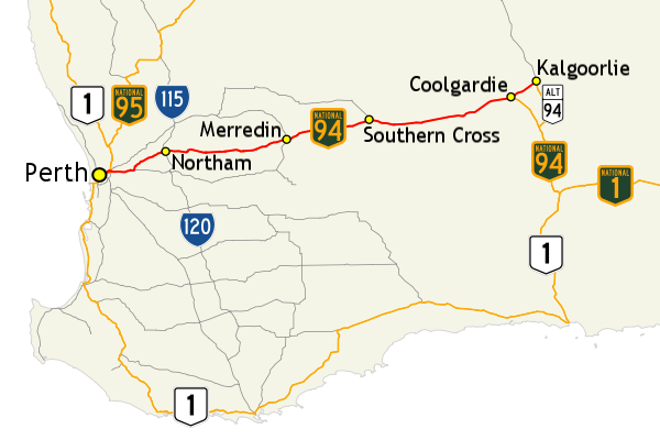
Great Eastern Highway is a 590-kilometre-long (370 mi) road that links the Western Australian capital of Perth with the city of Kalgoorlie. A key route for road vehicles accessing the eastern Wheatbelt and the Goldfields, it is the western portion of the main road link between Perth and the eastern states of Australia. The highway forms the majority of National Highway 94, although the alignment through the Perth suburbs of Guildford and Midland, and the eastern section between Coolgardie and Kalgoorlie are not included. Various segments form parts of other road routes, including National Route 1, Alternative National Route 94, and State Route 51.
There are numerous intersections in Perth with other highways and main roads, including Canning, Albany, Tonkin and Roe Highways, and Graham Farmer Freeway. There are also two rural highways that spur off Great Eastern Highway. Great Southern Highway begins near Perth's eastern metropolitan boundary, linking towns such as York, Brookton, Narrogin, and Katanning. Near the eastern end of the highway, Coolgardie is the starting point of Coolgardie–Esperance Highway, connecting to the interstate route Eyre Highway at Norseman, as well as the coastal town of Esperance.
The highway was created in the 1930s from an existing system of roads linking Perth with the Goldfields. Though the name Great Eastern Highway was coined to describe the route from Perth to Guildford on the northern side of the Swan River (modern-day Guildford Road), it was actually used for the road through Belmont, south of the river. This section was constructed in 1867 using convict labour, with the road base made from sections of tree trunks. Over the years the road has been upgraded, with the whole highway sealed by 1953, segments reconstructed and widened, dual carriageways created in Perth and Kalgoorlie, and grade separated interchanges built at major intersections. Great Eastern Highway Bypass in Perth's eastern suburbs opened in 1988, allowing through traffic to avoid the Guildford and Midland townsites, and in 2002 a new bypass diverted the highway around Northam. A future route to replace Great Eastern Highway's current ascent of the Darling Scarp has been planned and named EastLink WA. The planned route is a controlled-access highway along Toodyay Road to Gidgegannup, and then across to Wundowie via a new alignment. Though planning began in the 1970s, construction is expected to begin in 2025.
Great Eastern Highway commences at The Causeway, a river crossing that connects to Perth's central business district. Travelling north-east through the city to Greenmount Hill, and following a steep climb, the highway heads east through Western Australia's Wheatbelt to Kalgoorlie, in the state's Goldfields. Within Perth, the highway is a six-lane dual carriageway from The Causeway to Tonkin Highway near Perth Airport. It travels as a four lane single carriageway to Midland, with the second carriageway reappearing after Roe Highway, and continuing all the way to The Lakes at Perth's eastern fringe. The remainder of the highway is a two-lane single carriageway until Kalgoorlie, where a dual carriageway exists. The speed limit is 60 kilometres per hour (35 mph) from The Causeway to Midland, 70 km/h (45 mph) near the bottom of Greenmount Hill, and 80 km/h (50 mph) from Greenmount to Sawyers Valley. From the eastern edge of Perth it is generally 110 km/h (70 mph), but with lower limits for sections near the towns the highway encounters en route to Kalgoorlie.
The highway runs mostly parallel to the Mundaring to Kalgoorlie water pipeline, which supplies the Goldfields with water from Mundaring Weir in the eastern part of Perth. The Golden Pipeline Heritage Trail is a tourist drive alongside the pipeline, with large sections of the trail following Great Eastern Highway. Various road routes are allocated to sections of Great Eastern Highway, with some overlap between some of the routes. It is mostly signed as National Highway 94, except for the section between Great Eastern Highway Bypass and Roe Highway, and the final 40 kilometres (25 mi) from Coolgardie to Kalgoorlie. It is also signed as National Route 1 between The Causeway and Morrison Road in Midland, State Route 51 between Johnson Street in Guildford and Roe Highway, Tourist Drive 203 between Terrace Road in Guildford and Morrison Road, Midland, and Alternate National Route 94 east of Coolgardie.
Main Roads Western Australia monitors traffic volume across the state's road network, including various locations along Great Eastern Highway. In 2008/09, the busiest section was east of the Graham Farmer Freeway interchange, averaging 60,760 vehicles per weekday. The lowest volume was an average of 850 vehicles per day near Ryans Find Road, partway between Southern Cross and Coolgardie; however, this point also received the largest proportion of heavy vehicles, at 40.2% of all traffic. As of 2012[update], Great Eastern Highway between Mundaring and Northam is the state's worst section of National Highway, in terms of road safety. Casualty crash rates had decreased since 2007, although the Royal Automobile Club of Western Australia (RAC) still considered it a risky section of road needing close attention from road authorities. In 2013, Great Eastern Highway remained as a road of particular concern, with the Australian Automobile Association giving 67% of the highway a low one- or two-star rating (out of five), and 77% of the route between The Lakes and Northam a one-star safety rating.
Great Eastern Highway begins at a grade separated interchange between the south-eastern end of The Causeway, north-eastern end of Canning Highway, and north-western ends of Shepperton Road and Albany Highway. It proceeds in a north-easterly direction between local parks for 1.3 kilometres (0.8 mi), south of the Crown Perth entertainment complex in Burswood. After passing under the Armadale line, there is a diamond interchange with Graham Farmer Freeway to the north-west and Orrong Road to the south-east, with an additional south-westbound to north-westbound looped ramp. The highway continues north-east, parallel to the Swan River, through the residential and commercial areas of Rivervale, Belmont, Ascot, and Redcliffe. There are many at-grade intersections and driveway access crossovers in these high density suburbs. Major intersections are controlled by traffic lights, while many others are left-in/left-out. After 4.6 kilometres (2.9 mi), Great Eastern Highway interchanges with Tonkin Highway, which connects to Perth's north-eastern and south-eastern suburbs. Until September 2018, the interchange was also connected to Brearley Avenue, which provided access to Perth Airport's domestic terminals. The connection was removed due to the construction of Redcliffe railway station as part of the Forrestfield-Airport Link. The main connection linking Great Eastern Highway to the precinct is now at Fauntleroy Avenue to the north-east.
The road travels for another 2.1 kilometres (1.3 mi) along the border between Ascot and Redcliffe, before reaching a traffic light controlled fork with Great Eastern Highway Bypass. The main traffic flow continues east on the bypass to Roe Highway, while the Great Eastern Highway runs north-east through South Guildford for 2 kilometres (1.2 mi), separating a narrow residential area along the Swan River from industrial development in the rest of the suburb. The highway crosses the Helena River via a two-lane bridge, and continues north into the historic townsite of Guildford, named as Johnson Street. After 800 metres (2,600 ft), Johnson Street terminates at a T junction, just south of the Midland railway line. The highway turns east onto James Street, which after 1.2 kilometres (0.75 mi) has a sharp 90 degree turn to the north, continuing as East Street for 450 metres (1,480 ft). Following a level crossing of the railway, and an adjacent set of traffic lights at Terrace Road, the name Great Eastern Highway is resumed.
Great Eastern Highway
Great Eastern Highway is a 590-kilometre-long (370 mi) road that links the Western Australian capital of Perth with the city of Kalgoorlie. A key route for road vehicles accessing the eastern Wheatbelt and the Goldfields, it is the western portion of the main road link between Perth and the eastern states of Australia. The highway forms the majority of National Highway 94, although the alignment through the Perth suburbs of Guildford and Midland, and the eastern section between Coolgardie and Kalgoorlie are not included. Various segments form parts of other road routes, including National Route 1, Alternative National Route 94, and State Route 51.
There are numerous intersections in Perth with other highways and main roads, including Canning, Albany, Tonkin and Roe Highways, and Graham Farmer Freeway. There are also two rural highways that spur off Great Eastern Highway. Great Southern Highway begins near Perth's eastern metropolitan boundary, linking towns such as York, Brookton, Narrogin, and Katanning. Near the eastern end of the highway, Coolgardie is the starting point of Coolgardie–Esperance Highway, connecting to the interstate route Eyre Highway at Norseman, as well as the coastal town of Esperance.
The highway was created in the 1930s from an existing system of roads linking Perth with the Goldfields. Though the name Great Eastern Highway was coined to describe the route from Perth to Guildford on the northern side of the Swan River (modern-day Guildford Road), it was actually used for the road through Belmont, south of the river. This section was constructed in 1867 using convict labour, with the road base made from sections of tree trunks. Over the years the road has been upgraded, with the whole highway sealed by 1953, segments reconstructed and widened, dual carriageways created in Perth and Kalgoorlie, and grade separated interchanges built at major intersections. Great Eastern Highway Bypass in Perth's eastern suburbs opened in 1988, allowing through traffic to avoid the Guildford and Midland townsites, and in 2002 a new bypass diverted the highway around Northam. A future route to replace Great Eastern Highway's current ascent of the Darling Scarp has been planned and named EastLink WA. The planned route is a controlled-access highway along Toodyay Road to Gidgegannup, and then across to Wundowie via a new alignment. Though planning began in the 1970s, construction is expected to begin in 2025.
Great Eastern Highway commences at The Causeway, a river crossing that connects to Perth's central business district. Travelling north-east through the city to Greenmount Hill, and following a steep climb, the highway heads east through Western Australia's Wheatbelt to Kalgoorlie, in the state's Goldfields. Within Perth, the highway is a six-lane dual carriageway from The Causeway to Tonkin Highway near Perth Airport. It travels as a four lane single carriageway to Midland, with the second carriageway reappearing after Roe Highway, and continuing all the way to The Lakes at Perth's eastern fringe. The remainder of the highway is a two-lane single carriageway until Kalgoorlie, where a dual carriageway exists. The speed limit is 60 kilometres per hour (35 mph) from The Causeway to Midland, 70 km/h (45 mph) near the bottom of Greenmount Hill, and 80 km/h (50 mph) from Greenmount to Sawyers Valley. From the eastern edge of Perth it is generally 110 km/h (70 mph), but with lower limits for sections near the towns the highway encounters en route to Kalgoorlie.
The highway runs mostly parallel to the Mundaring to Kalgoorlie water pipeline, which supplies the Goldfields with water from Mundaring Weir in the eastern part of Perth. The Golden Pipeline Heritage Trail is a tourist drive alongside the pipeline, with large sections of the trail following Great Eastern Highway. Various road routes are allocated to sections of Great Eastern Highway, with some overlap between some of the routes. It is mostly signed as National Highway 94, except for the section between Great Eastern Highway Bypass and Roe Highway, and the final 40 kilometres (25 mi) from Coolgardie to Kalgoorlie. It is also signed as National Route 1 between The Causeway and Morrison Road in Midland, State Route 51 between Johnson Street in Guildford and Roe Highway, Tourist Drive 203 between Terrace Road in Guildford and Morrison Road, Midland, and Alternate National Route 94 east of Coolgardie.
Main Roads Western Australia monitors traffic volume across the state's road network, including various locations along Great Eastern Highway. In 2008/09, the busiest section was east of the Graham Farmer Freeway interchange, averaging 60,760 vehicles per weekday. The lowest volume was an average of 850 vehicles per day near Ryans Find Road, partway between Southern Cross and Coolgardie; however, this point also received the largest proportion of heavy vehicles, at 40.2% of all traffic. As of 2012[update], Great Eastern Highway between Mundaring and Northam is the state's worst section of National Highway, in terms of road safety. Casualty crash rates had decreased since 2007, although the Royal Automobile Club of Western Australia (RAC) still considered it a risky section of road needing close attention from road authorities. In 2013, Great Eastern Highway remained as a road of particular concern, with the Australian Automobile Association giving 67% of the highway a low one- or two-star rating (out of five), and 77% of the route between The Lakes and Northam a one-star safety rating.
Great Eastern Highway begins at a grade separated interchange between the south-eastern end of The Causeway, north-eastern end of Canning Highway, and north-western ends of Shepperton Road and Albany Highway. It proceeds in a north-easterly direction between local parks for 1.3 kilometres (0.8 mi), south of the Crown Perth entertainment complex in Burswood. After passing under the Armadale line, there is a diamond interchange with Graham Farmer Freeway to the north-west and Orrong Road to the south-east, with an additional south-westbound to north-westbound looped ramp. The highway continues north-east, parallel to the Swan River, through the residential and commercial areas of Rivervale, Belmont, Ascot, and Redcliffe. There are many at-grade intersections and driveway access crossovers in these high density suburbs. Major intersections are controlled by traffic lights, while many others are left-in/left-out. After 4.6 kilometres (2.9 mi), Great Eastern Highway interchanges with Tonkin Highway, which connects to Perth's north-eastern and south-eastern suburbs. Until September 2018, the interchange was also connected to Brearley Avenue, which provided access to Perth Airport's domestic terminals. The connection was removed due to the construction of Redcliffe railway station as part of the Forrestfield-Airport Link. The main connection linking Great Eastern Highway to the precinct is now at Fauntleroy Avenue to the north-east.
The road travels for another 2.1 kilometres (1.3 mi) along the border between Ascot and Redcliffe, before reaching a traffic light controlled fork with Great Eastern Highway Bypass. The main traffic flow continues east on the bypass to Roe Highway, while the Great Eastern Highway runs north-east through South Guildford for 2 kilometres (1.2 mi), separating a narrow residential area along the Swan River from industrial development in the rest of the suburb. The highway crosses the Helena River via a two-lane bridge, and continues north into the historic townsite of Guildford, named as Johnson Street. After 800 metres (2,600 ft), Johnson Street terminates at a T junction, just south of the Midland railway line. The highway turns east onto James Street, which after 1.2 kilometres (0.75 mi) has a sharp 90 degree turn to the north, continuing as East Street for 450 metres (1,480 ft). Following a level crossing of the railway, and an adjacent set of traffic lights at Terrace Road, the name Great Eastern Highway is resumed.
Recent media
Recent media