Community hub
Recent from talks
Knowledge base stats:
Talk channels stats:
Members stats:
Hood Canal
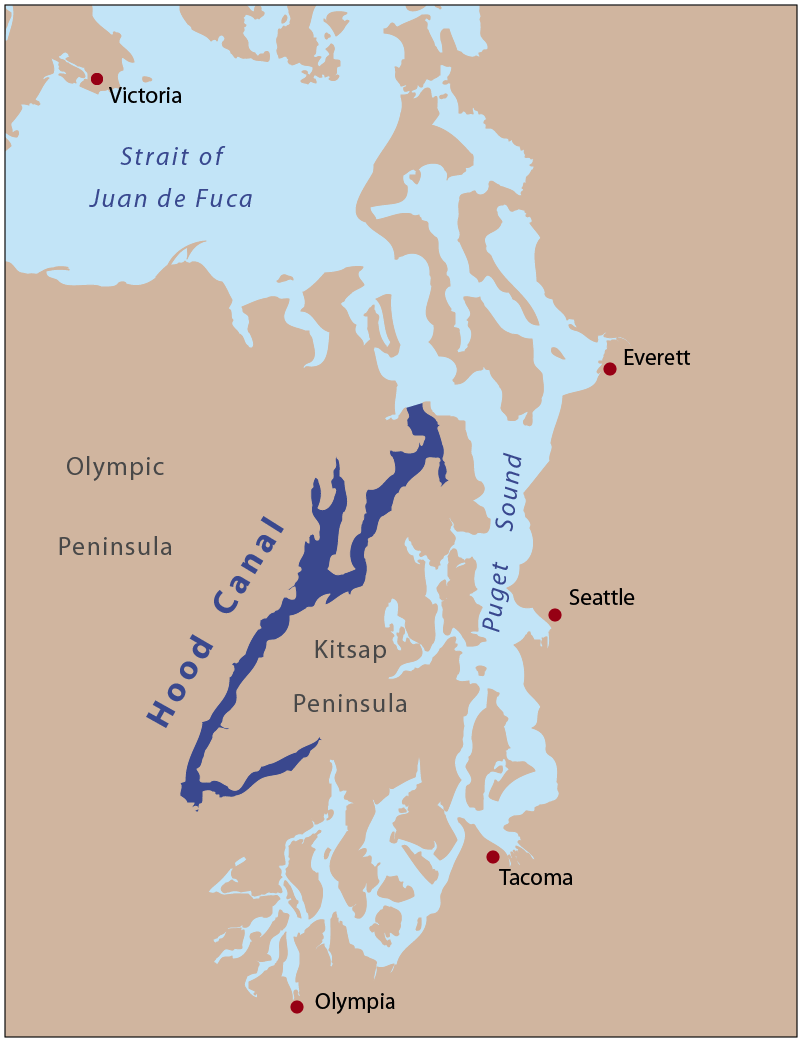
Hood Canal is a fjord-like body of water that lies south of Admiralty Inlet in Washington State that some consider to be the western lobe and one of the five main basins of Puget Sound. It is one of the minor bodies of water that constitute the Salish Sea. Maximum depth is 600 ft. Hood Canal is not a canal in the sense of an artificial waterway—it is a natural feature.
Hood Canal is long and narrow with an average width of 1.5 miles (2.4 km) and a mean depth of 53.8 metres (177 ft). It has 342.6 kilometres (212.9 mi) of shoreline and 42.4 square kilometres (16.4 sq mi) of tideland. Its surface area is 385.6 square kilometres (148.9 sq mi) and it contains a volume of water totaling 21 cubic kilometres (17,000,000 acre⋅ft). Hood Canal extends for about 50 miles (80 km) southwest from the entrance between Foulweather Bluff and Tala Point to Union, where it turns sharply to the northeast, a stretch called The Great Bend. It continues for about 15 miles (24 km) to Belfair, where it ends in a shallow tideland called Lynch Cove.
Along its entire length, Hood Canal separates the Kitsap Peninsula from the Olympic Peninsula of Washington. The U.S. Navy's Naval Base Kitsap, Bangor Annex, is located on the eastern shore of Hood Canal near the town of Silverdale. Hood Canal has several internal bays, the largest of which is Dabob Bay. Most of Dabob Bay is a Naval Restricted Area, and is used by the submarines stationed at the Bangor Base. Quilcene Bay is an inlet extending northwest from Dabob Bay. Near the north end of Hood Canal is Port Gamble, a bay and a town of the same name.
Several rivers flow into Hood Canal, mostly from the Olympic Peninsula, including the Skokomish River, Hamma Hamma River, Duckabush River, Dosewallips River, and Big Quilcene River. Small rivers emptying into Hood Canal from the Kitsap Peninsula include the Union River, Tahuya River, and Dewatto River.
Hood Canal and the rest of Puget Sound were created about 13,000 years ago, during the Late Pleistocene, by the Puget Lobe of the Cordilleran Ice Sheet.
Hood Canal has a population of salmon that return annually to spawn in local rivers; in 2024, local volunteers counted over 12,500 salmon in the Hood Canal drainage basin after the completion of several restoration projects. Killer whales have been spotted occasionally in Hood Canal, including members of the endangered southern resident population. In 2021, a pod spent 30 days in Hood Canal and reached as far as Belfair. The U.S. Navy began deployment of trained dolphins in Hood Canal in 2010 to patrol the areas around its submarine base at Bangor.
Hood Canal was named by the Royal Navy Captain George Vancouver on May 13, 1792, in honor of Admiral Lord Samuel Hood of that navy. Vancouver used the name "Hood's Channel" in his journal, but wrote "Hood's Canal" on his charts. The United States Board on Geographic Names decided on "Hood Canal" as its official name in 1932.
U.S. Route 101 runs along the west shore of Hood Canal, south of Quilcene.
Hub AI
Hood Canal AI simulator
(@Hood Canal_simulator)
Hood Canal
Hood Canal is a fjord-like body of water that lies south of Admiralty Inlet in Washington State that some consider to be the western lobe and one of the five main basins of Puget Sound. It is one of the minor bodies of water that constitute the Salish Sea. Maximum depth is 600 ft. Hood Canal is not a canal in the sense of an artificial waterway—it is a natural feature.
Hood Canal is long and narrow with an average width of 1.5 miles (2.4 km) and a mean depth of 53.8 metres (177 ft). It has 342.6 kilometres (212.9 mi) of shoreline and 42.4 square kilometres (16.4 sq mi) of tideland. Its surface area is 385.6 square kilometres (148.9 sq mi) and it contains a volume of water totaling 21 cubic kilometres (17,000,000 acre⋅ft). Hood Canal extends for about 50 miles (80 km) southwest from the entrance between Foulweather Bluff and Tala Point to Union, where it turns sharply to the northeast, a stretch called The Great Bend. It continues for about 15 miles (24 km) to Belfair, where it ends in a shallow tideland called Lynch Cove.
Along its entire length, Hood Canal separates the Kitsap Peninsula from the Olympic Peninsula of Washington. The U.S. Navy's Naval Base Kitsap, Bangor Annex, is located on the eastern shore of Hood Canal near the town of Silverdale. Hood Canal has several internal bays, the largest of which is Dabob Bay. Most of Dabob Bay is a Naval Restricted Area, and is used by the submarines stationed at the Bangor Base. Quilcene Bay is an inlet extending northwest from Dabob Bay. Near the north end of Hood Canal is Port Gamble, a bay and a town of the same name.
Several rivers flow into Hood Canal, mostly from the Olympic Peninsula, including the Skokomish River, Hamma Hamma River, Duckabush River, Dosewallips River, and Big Quilcene River. Small rivers emptying into Hood Canal from the Kitsap Peninsula include the Union River, Tahuya River, and Dewatto River.
Hood Canal and the rest of Puget Sound were created about 13,000 years ago, during the Late Pleistocene, by the Puget Lobe of the Cordilleran Ice Sheet.
Hood Canal has a population of salmon that return annually to spawn in local rivers; in 2024, local volunteers counted over 12,500 salmon in the Hood Canal drainage basin after the completion of several restoration projects. Killer whales have been spotted occasionally in Hood Canal, including members of the endangered southern resident population. In 2021, a pod spent 30 days in Hood Canal and reached as far as Belfair. The U.S. Navy began deployment of trained dolphins in Hood Canal in 2010 to patrol the areas around its submarine base at Bangor.
Hood Canal was named by the Royal Navy Captain George Vancouver on May 13, 1792, in honor of Admiral Lord Samuel Hood of that navy. Vancouver used the name "Hood's Channel" in his journal, but wrote "Hood's Canal" on his charts. The United States Board on Geographic Names decided on "Hood Canal" as its official name in 1932.
U.S. Route 101 runs along the west shore of Hood Canal, south of Quilcene.