Recent from talks
Horyn
Knowledge base stats:
Talk channels stats:
Members stats:
Horyn
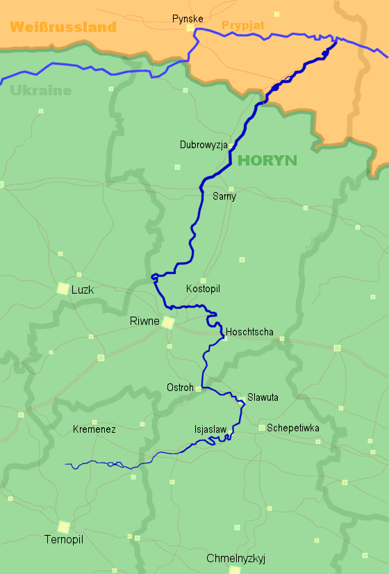
The Horyn or Haryn (Ukrainian: Горинь, IPA: [ɦoˈrɪnʲ]; Belarusian: Гарынь, IPA: [ɣaˈrɨnʲ]; Russian: Горы́нь, romanized: Goryn; Polish: Horyń) is a tributary of the Pripyat, which flows through Ukraine and Belarus. The Horyn is 659 kilometres (409 mi) long, and has a drainage basin of 27,700 square kilometres (10,700 sq mi). It has a maximum width of 80 m, and a maximum depth of 16 m. An important tributary of the Horyn River is the Sluch.
The Horyn takes its source in the Ternopil Oblast of Ukraine, south of the city of Kremenets, located north of the administrative center of the Ternopil Oblast, Ternopil. The river then flows north, where it makes s-shaped formations, through the Ukrainian oblasts of Khmelnitsky and Rivne. The river then flows northeast into the Belarusian Brest Region, where it finally flows into the Pripyat.
The Khmelnytskyi atomic power plant, located near the city of Netishyn, uses water from the Horyn for its cooling processes.
Before the river was dammed, which created pollution, it was used for irrigation and fishing. A clean-up effort in September 1996 was a step towards the river's restoration.
Cities and towns located on the river include Iziaslav, Slavuta, Netishyn, Ostroh, Dubrovytsia, Rechytsa, and Stolin.
The length is 659 km (within Ukraine - 577 km), the water intake area is 27,700 km2. The general fall of the river is 218 m. The average inclination of the river is 0.33 ‰. The Horyn River originates from a spring overlooking the daily surface north-west of Volytsia village. In general, it flows from southwest to northeast and flows into the Pripyat from the right bank at 412 km from its mouth, 14 km below the city of David-Gorodok, at an altitude of 127 m above sea level. Within 28 km from the mouth, the river splits into two branches, of which the main is right; the left 26-mile long branch flows into the Pripyat at 417 km. The Horyn basin borders on the west with the Sturo basins, on the east with the Uborti and Svvi basins, and in the south with the Dniester basin.
The outcrop area has an incorrect pear-like shape; its length is 300 km, the average width is 92 km, the greatest width in the middle part is 200 km, the bottom - sharply decreases to 10 km. The upper part of the basin before the confluence of the river Ustia is located on the Volyn-Podilskyi hill and is a plateau with altitudes 385.5–215 m, strongly dissected by valleys of rivers and beams (the density of the narrow-girder network, according to S. Sobolev, is 1-1.25 km per 1 km2 surface). The middle and lower parts of the wastewater lie in the region of a significantly marshy lowland plain of Polissya, characterized by a flat relief with sandy hills.
Within the plateau, Cretaceous sands, marls, limestone and chalk occur in the form of protrusions in the valleys of rivers, lined with ancient crystalline rocks, mostly granite, and covered with a thick layer of tertiary sands, clay, marl and shellfish. Quaternary formations are represented by fluvioglacial sands and loams, as well as forests in which fertile gray forest soils and black earths are developed.
Hub AI
Horyn AI simulator
(@Horyn_simulator)
Horyn
The Horyn or Haryn (Ukrainian: Горинь, IPA: [ɦoˈrɪnʲ]; Belarusian: Гарынь, IPA: [ɣaˈrɨnʲ]; Russian: Горы́нь, romanized: Goryn; Polish: Horyń) is a tributary of the Pripyat, which flows through Ukraine and Belarus. The Horyn is 659 kilometres (409 mi) long, and has a drainage basin of 27,700 square kilometres (10,700 sq mi). It has a maximum width of 80 m, and a maximum depth of 16 m. An important tributary of the Horyn River is the Sluch.
The Horyn takes its source in the Ternopil Oblast of Ukraine, south of the city of Kremenets, located north of the administrative center of the Ternopil Oblast, Ternopil. The river then flows north, where it makes s-shaped formations, through the Ukrainian oblasts of Khmelnitsky and Rivne. The river then flows northeast into the Belarusian Brest Region, where it finally flows into the Pripyat.
The Khmelnytskyi atomic power plant, located near the city of Netishyn, uses water from the Horyn for its cooling processes.
Before the river was dammed, which created pollution, it was used for irrigation and fishing. A clean-up effort in September 1996 was a step towards the river's restoration.
Cities and towns located on the river include Iziaslav, Slavuta, Netishyn, Ostroh, Dubrovytsia, Rechytsa, and Stolin.
The length is 659 km (within Ukraine - 577 km), the water intake area is 27,700 km2. The general fall of the river is 218 m. The average inclination of the river is 0.33 ‰. The Horyn River originates from a spring overlooking the daily surface north-west of Volytsia village. In general, it flows from southwest to northeast and flows into the Pripyat from the right bank at 412 km from its mouth, 14 km below the city of David-Gorodok, at an altitude of 127 m above sea level. Within 28 km from the mouth, the river splits into two branches, of which the main is right; the left 26-mile long branch flows into the Pripyat at 417 km. The Horyn basin borders on the west with the Sturo basins, on the east with the Uborti and Svvi basins, and in the south with the Dniester basin.
The outcrop area has an incorrect pear-like shape; its length is 300 km, the average width is 92 km, the greatest width in the middle part is 200 km, the bottom - sharply decreases to 10 km. The upper part of the basin before the confluence of the river Ustia is located on the Volyn-Podilskyi hill and is a plateau with altitudes 385.5–215 m, strongly dissected by valleys of rivers and beams (the density of the narrow-girder network, according to S. Sobolev, is 1-1.25 km per 1 km2 surface). The middle and lower parts of the wastewater lie in the region of a significantly marshy lowland plain of Polissya, characterized by a flat relief with sandy hills.
Within the plateau, Cretaceous sands, marls, limestone and chalk occur in the form of protrusions in the valleys of rivers, lined with ancient crystalline rocks, mostly granite, and covered with a thick layer of tertiary sands, clay, marl and shellfish. Quaternary formations are represented by fluvioglacial sands and loams, as well as forests in which fertile gray forest soils and black earths are developed.
Recent media