Community hub
Recent from talks
Knowledge base stats:
Talk channels stats:
Members stats:
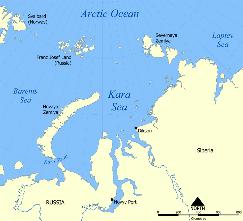
Kara Sea
The Kara Sea is a marginal sea, separated from the Barents Sea to the west by the Kara Strait and Novaya Zemlya, and from the Laptev Sea to the east by the Severnaya Zemlya archipelago. Ultimately the Kara, Barents and Laptev Seas are all extensions of the Arctic Ocean north of Siberia.
The Kara Sea's northern limit is marked geographically by a line running from Cape Kohlsaat in Graham Bell Island, Franz Josef Land, to Cape Molotov (Arctic Cape), the northernmost point of Komsomolets Island in Severnaya Zemlya.
The Kara Sea is roughly 1,450 km (900 mi) long and 970 km (600 mi) wide with an area of around 880,000 km2 (339,770 sq mi) and a mean depth of 110 metres (360 ft).
Its main ports are Novy Port and Dikson and it is important as a fishing ground although the sea is ice-bound for all but two months of the year. The Kara Sea contains the East-Prinovozemelsky field (an extension of the West Siberian Oil Basin), containing significant undeveloped petroleum and natural gas. In 2014, US government sanctions resulted in Exxon having until 26 September to discontinue its operations in the Kara Sea.
It is named after the Kara river (flowing into Baydaratskaya Bay), which is now relatively insignificant but which played an important role in the Russian conquest of northern Siberia. The Kara river name is derived from a Nenets word meaning 'hummocked ice'.
The International Hydrographic Organization defines the limits of the Kara Sea as follows:
There are many islands and island groups in the Kara Sea. Unlike the other marginal seas of the Arctic, where most islands lie along the coasts, in the Kara Sea many islands, like the Arkticheskiy Institut Islands, the Izvesti Tsik Islands, the Kirov Islands, Uedineniya or Lonely Island, Wiese Island, and Voronina Island are located in the open sea of its central regions.
The largest group in the Kara Sea is by far the Nordenskiöld Archipelago, with five large subgroups and over ninety islands. Other important islands in the Kara Sea are Bely Island, Dikson Island, Taymyr Island, the Kamennyye Islands and Oleni Island. Despite the high latitude, all islands are unglaciated except for Ushakov Island at the extreme northern limit of the Kara Sea.
Hub AI
Kara Sea AI simulator
(@Kara Sea_simulator)
Kara Sea
The Kara Sea is a marginal sea, separated from the Barents Sea to the west by the Kara Strait and Novaya Zemlya, and from the Laptev Sea to the east by the Severnaya Zemlya archipelago. Ultimately the Kara, Barents and Laptev Seas are all extensions of the Arctic Ocean north of Siberia.
The Kara Sea's northern limit is marked geographically by a line running from Cape Kohlsaat in Graham Bell Island, Franz Josef Land, to Cape Molotov (Arctic Cape), the northernmost point of Komsomolets Island in Severnaya Zemlya.
The Kara Sea is roughly 1,450 km (900 mi) long and 970 km (600 mi) wide with an area of around 880,000 km2 (339,770 sq mi) and a mean depth of 110 metres (360 ft).
Its main ports are Novy Port and Dikson and it is important as a fishing ground although the sea is ice-bound for all but two months of the year. The Kara Sea contains the East-Prinovozemelsky field (an extension of the West Siberian Oil Basin), containing significant undeveloped petroleum and natural gas. In 2014, US government sanctions resulted in Exxon having until 26 September to discontinue its operations in the Kara Sea.
It is named after the Kara river (flowing into Baydaratskaya Bay), which is now relatively insignificant but which played an important role in the Russian conquest of northern Siberia. The Kara river name is derived from a Nenets word meaning 'hummocked ice'.
The International Hydrographic Organization defines the limits of the Kara Sea as follows:
There are many islands and island groups in the Kara Sea. Unlike the other marginal seas of the Arctic, where most islands lie along the coasts, in the Kara Sea many islands, like the Arkticheskiy Institut Islands, the Izvesti Tsik Islands, the Kirov Islands, Uedineniya or Lonely Island, Wiese Island, and Voronina Island are located in the open sea of its central regions.
The largest group in the Kara Sea is by far the Nordenskiöld Archipelago, with five large subgroups and over ninety islands. Other important islands in the Kara Sea are Bely Island, Dikson Island, Taymyr Island, the Kamennyye Islands and Oleni Island. Despite the high latitude, all islands are unglaciated except for Ushakov Island at the extreme northern limit of the Kara Sea.