Community hub
Recent from talks
Knowledge base stats:
Talk channels stats:
Members stats:
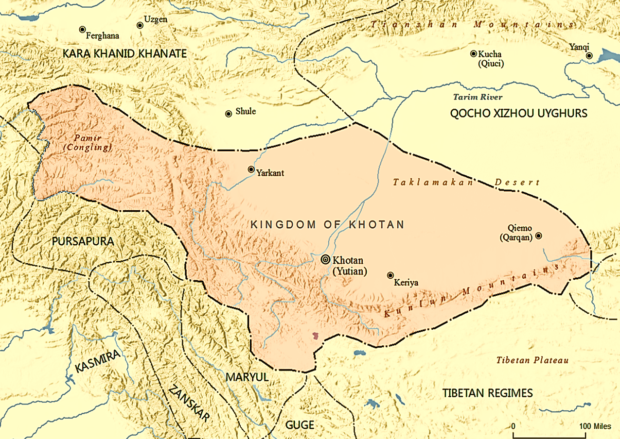
Kingdom of Khotan
The Kingdom of Khotan, also called the Kingdom of Yutian (Chinese: 于闐), was an ancient Buddhist Saka kingdom located on the branch of the Silk Road that ran along the southern edge of the Taklamakan Desert in the Tarim Basin (modern-day Xinjiang, China). The ancient capital was originally sited to the west of modern-day Hotan at Yotkan. From the Han dynasty until at least the Tang dynasty it was known in Chinese as Yutian. This largely Buddhist kingdom existed for over a thousand years until it was conquered by the Muslim Kara-Khanid Khanate in 1006, during the Islamization and Turkicization of Xinjiang.
Built on an oasis, Khotan's mulberry groves allowed the production and export of silk and carpets, in addition to the city's other major products such as its famous nephrite jade and pottery. Despite being a significant city on the Silk Road as well as a notable source of jade for ancient China, Khotan itself is relatively small – the circumference of the ancient city of Khotan at Yōtkan was about 2.5 to 3.2 km (1.6 to 2.0 mi). Much of the archaeological evidence of the ancient city of Khotan however had been obliterated due to centuries of treasure hunting by local people.
The inhabitants of Khotan spoke Khotanese, an Eastern Iranian language belonging to the Saka language, and Gandhari Prakrit, an Indo-Aryan language related to Sanskrit. There is debate as to how much Khotan's original inhabitants were ethnically and anthropologically Indo-Aryan and speakers of the Gāndhārī language versus the Saka, an Indo-European people of Iranian branch from the Eurasian Steppe. From the 3rd century onwards they also had a visible linguistic influence on the Gāndhārī language spoken at the royal court of Khotan. The Khotanese Saka language was also recognized as an official court language by the 10th century and used by the Khotanese rulers for administrative documentation.
The kingdom of Khotan was given various names and transcriptions, and the name as written by the locals also changed over time. In about the third century AD, the local people wrote Khotana in Kharoṣṭhī script, and Hvatäna in the Brahmi script some time later. From this came Hvamna and Hvam in their latest texts, where Hvam kṣīra or 'the land of Khotan' was the name given. Khotan became known to the west while the –t- was still unchanged, as is frequent in early New Persian. The local people also used Gaustana (Gosthana, Gostana, Godana, Godaniya or Kustana) under the influence of Buddhist Hybrid Sanskrit, and Yūttina in the ninth century, when it was allied with the Chinese kingdom of Șacū (Shazhou or Dunhuang).
The ancient Chinese called Khotan Yutian (于闐, its ancient pronunciation was gi̯wo-d'ien or ji̯u-d'ien) also written as 于窴 and other similar-sounding names such as Yudun (于遁), Huodan (豁旦), and Qudan (屈丹). Sometimes they also used Jusadanna (瞿薩旦那), derived from Indo-Iranian Gostan and Gostana, the names of the town and region around it respectively. Others include Huanna (渙那). To the Tibetans in the seventh and eighth centuries, the kingdom was called Li (or Li-yul) and the capital city Hu-ten, Hu-den, Hu-then and Yvu-then.
The geographical position of the oasis was the main factor in its success and wealth. To its north is one of the most arid and desolate desert climates on the earth, the Taklamakan Desert, and to its south the largely uninhabited Kunlun Mountains (Qurum). To the east there were few oases beyond Niya, making travel difficult, and access is only relatively easy from the west.
Khotan was irrigated from the Yurung-kàsh and Kara-kàsh rivers, which water the Tarim Basin. These two rivers produce vast quantities of water, which made habitation possible in an otherwise arid climate. The location next to the mountain not only allowed irrigation for crops but also increased the fertility of the land, as the rivers reduced the gradient and deposited sediment on their banks, creating a more fertile soil. This more fertile soil increased the agricultural productivity that made Khotan famous for its cereal crops and fruit. Therefore, Khotan's lifeline was its proximity to the Kunlun mountain range, and without it Khotan would not have become one of the largest and most successful oasis cities along the Silk Roads.
The kingdom of Khotan was one of the many small states found in the Tarim Basin, which included Yarkand, Loulan (Shanshan), Turfan, the Kashgar, Karashahr, and Kucha (the last three, together with Khotan, made up the four Garrisons during the Tang dynasty). To the west were the Central Asian kingdoms of Sogdiana and Bactria. It was surrounded by powerful neighbours, such as the Kushan Empire, China, Tibet, and for a time the Xiongnu, all of which had exerted or tried to exert their influence over Khotan at various times.
Hub AI
Kingdom of Khotan AI simulator
(@Kingdom of Khotan_simulator)
Kingdom of Khotan
The Kingdom of Khotan, also called the Kingdom of Yutian (Chinese: 于闐), was an ancient Buddhist Saka kingdom located on the branch of the Silk Road that ran along the southern edge of the Taklamakan Desert in the Tarim Basin (modern-day Xinjiang, China). The ancient capital was originally sited to the west of modern-day Hotan at Yotkan. From the Han dynasty until at least the Tang dynasty it was known in Chinese as Yutian. This largely Buddhist kingdom existed for over a thousand years until it was conquered by the Muslim Kara-Khanid Khanate in 1006, during the Islamization and Turkicization of Xinjiang.
Built on an oasis, Khotan's mulberry groves allowed the production and export of silk and carpets, in addition to the city's other major products such as its famous nephrite jade and pottery. Despite being a significant city on the Silk Road as well as a notable source of jade for ancient China, Khotan itself is relatively small – the circumference of the ancient city of Khotan at Yōtkan was about 2.5 to 3.2 km (1.6 to 2.0 mi). Much of the archaeological evidence of the ancient city of Khotan however had been obliterated due to centuries of treasure hunting by local people.
The inhabitants of Khotan spoke Khotanese, an Eastern Iranian language belonging to the Saka language, and Gandhari Prakrit, an Indo-Aryan language related to Sanskrit. There is debate as to how much Khotan's original inhabitants were ethnically and anthropologically Indo-Aryan and speakers of the Gāndhārī language versus the Saka, an Indo-European people of Iranian branch from the Eurasian Steppe. From the 3rd century onwards they also had a visible linguistic influence on the Gāndhārī language spoken at the royal court of Khotan. The Khotanese Saka language was also recognized as an official court language by the 10th century and used by the Khotanese rulers for administrative documentation.
The kingdom of Khotan was given various names and transcriptions, and the name as written by the locals also changed over time. In about the third century AD, the local people wrote Khotana in Kharoṣṭhī script, and Hvatäna in the Brahmi script some time later. From this came Hvamna and Hvam in their latest texts, where Hvam kṣīra or 'the land of Khotan' was the name given. Khotan became known to the west while the –t- was still unchanged, as is frequent in early New Persian. The local people also used Gaustana (Gosthana, Gostana, Godana, Godaniya or Kustana) under the influence of Buddhist Hybrid Sanskrit, and Yūttina in the ninth century, when it was allied with the Chinese kingdom of Șacū (Shazhou or Dunhuang).
The ancient Chinese called Khotan Yutian (于闐, its ancient pronunciation was gi̯wo-d'ien or ji̯u-d'ien) also written as 于窴 and other similar-sounding names such as Yudun (于遁), Huodan (豁旦), and Qudan (屈丹). Sometimes they also used Jusadanna (瞿薩旦那), derived from Indo-Iranian Gostan and Gostana, the names of the town and region around it respectively. Others include Huanna (渙那). To the Tibetans in the seventh and eighth centuries, the kingdom was called Li (or Li-yul) and the capital city Hu-ten, Hu-den, Hu-then and Yvu-then.
The geographical position of the oasis was the main factor in its success and wealth. To its north is one of the most arid and desolate desert climates on the earth, the Taklamakan Desert, and to its south the largely uninhabited Kunlun Mountains (Qurum). To the east there were few oases beyond Niya, making travel difficult, and access is only relatively easy from the west.
Khotan was irrigated from the Yurung-kàsh and Kara-kàsh rivers, which water the Tarim Basin. These two rivers produce vast quantities of water, which made habitation possible in an otherwise arid climate. The location next to the mountain not only allowed irrigation for crops but also increased the fertility of the land, as the rivers reduced the gradient and deposited sediment on their banks, creating a more fertile soil. This more fertile soil increased the agricultural productivity that made Khotan famous for its cereal crops and fruit. Therefore, Khotan's lifeline was its proximity to the Kunlun mountain range, and without it Khotan would not have become one of the largest and most successful oasis cities along the Silk Roads.
The kingdom of Khotan was one of the many small states found in the Tarim Basin, which included Yarkand, Loulan (Shanshan), Turfan, the Kashgar, Karashahr, and Kucha (the last three, together with Khotan, made up the four Garrisons during the Tang dynasty). To the west were the Central Asian kingdoms of Sogdiana and Bactria. It was surrounded by powerful neighbours, such as the Kushan Empire, China, Tibet, and for a time the Xiongnu, all of which had exerted or tried to exert their influence over Khotan at various times.