Community hub
Recent from talks
Knowledge base stats:
Talk channels stats:
Members stats:
Kola Peninsula
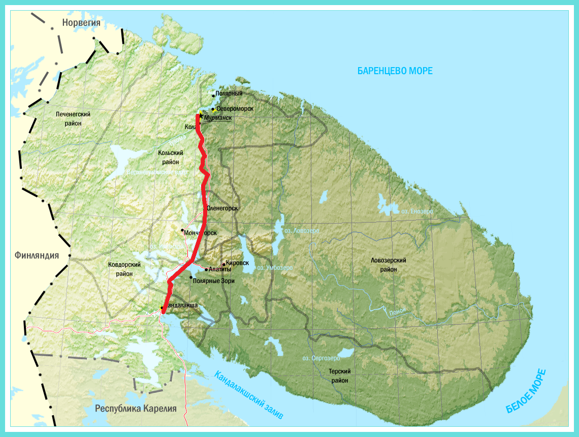
The Kola Peninsula (Russian: Ко́льский полуо́стров, romanized: Kolsky poluostrov; Kildin Sami: Куэлнэгк нёа̄ррк) is a peninsula in the extreme northwest of Russia, and one of the largest peninsulas of Europe. Constituting the bulk of the territory of Murmansk Oblast, it lies almost completely inside the Arctic Circle and is bordered by the Barents Sea to the north and by the White Sea to the east and southeast. The city of Murmansk, the most populous settlement on the peninsula, has a population of roughly 270,000 residents.
While humans had already settled in the north of the peninsula in the 7th–5th millennium BC, the rest of its territory remained uninhabited until the 3rd millennium BC, when various peoples started to arrive from the south. By the 1st millennium CE only the Sami people remained. This changed in the 12th century, when Russian Pomors discovered the peninsula's rich resources of game and fish. Soon after, the Pomors were followed by the tribute collectors from the Novgorod Republic, and the peninsula gradually became a part of the Novgorodian lands. However, the Novgorodians established no permanent settlements until the 15th century, and Russian migration continued in the following centuries.
The Soviet period (1917–1991) saw a rapid population increase, although most of the new arrivals remained confined to urbanized territories along the sea coast and the railroads. The Sami people were subject to forced collectivization, including forced relocation to Lovozero and other centralized settlements, and overall the peninsula became heavily industrialized and militarized, largely due to its strategic position (as the pre-eminent Soviet ice-free Atlantic coast) and to the discovery of the vast apatite deposits in the 1920s. As a result, the peninsula suffered major ecological damage. After the 1991 dissolution of the Soviet Union, the economy went into decline. Its population fell from 1,150,000 in 1989 to 795,000 in 2010. The peninsula recovered somewhat in the early 21st century, and is considered the most industrially developed and urbanized region in northern Russia.
Despite the peninsula's northerly location, its proximity to the North Atlantic Current (an extension of the Gulf Stream) leads to unusually high temperatures in winter, but also results in high winds due to the temperature variations between land and the Barents Sea. Summers are rather chilly, with the average July temperature of only 11 °C (52 °F). The peninsula is covered by taiga in the south and by tundra in the north, where permafrost limits the growth of trees, resulting in landscape dominated by shrubs and grasses. The peninsula supports a small variety of mammals, and its rivers are an important habitat for the Atlantic salmon. The Kandalaksha Nature Reserve, established to protect the population of common eider, is located in the Kandalaksha Gulf. The peninsula is also the site of the Kola Superdeep Borehole, the deepest hole drilled into the Earth.
The peninsula is located in the far northwest of Russia, almost completely inside the Arctic Circle and is bordered by the Barents Sea in the north and the White Sea in the east and southeast. Geologically, the peninsula occupies the northeastern edge of the Baltic Shield. The western border of the peninsula stretches along the meridian from the Kola Bay through the valley of the Kola River, Lake Imandra, and the Niva River to the Kandalaksha Gulf, although some sources push it all the way west to Russia's border with Finland.
Under a more restrictive definition, the peninsula covers an area of about 100,000 square kilometers (39,000 sq mi). The northern coast is steep and high, while the southern coast is flat. The western part of the peninsula is covered by two mountain ranges: the Khibiny Mountains and the Lovozero Massif; the former contains the highest point of the peninsula—Yudychvumchorr. Mount Chasnachorr, the height of which is 1,191 meters (3,907 ft), had been formerly considered the highest point of the Khibiny. The Keyvy drainage divide lies in the central part. The mountainous reliefs of the Murman and Kandalaksha Coasts stretch from southeast to northwest, mirroring the peninsula's main orographic features.
Administratively, the territory of the peninsula consists of Lovozersky and Tersky Districts, parts of Kandalakshsky and Kolsky Districts, as well as the territories subordinated to the cities and towns of Murmansk, Ostrovnoy, Severomorsk, Kirovsk, and parts of the territories subordinated to Apatity, Olenegorsk, and Polyarnye Zori.
Because the last ice age removed the top sediment layer of the soil, the surface of Kola Peninsula is extremely rich in various ores and minerals, including apatites and nephelines; copper, nickel, and iron ores; mica; kyanites; ceramic materials, as well as rare-earth elements and non-ferrous ores. Deposits of construction materials such as granite, quartzite, and limestone are also abundant. Diatomaceous earth deposits are common near lakes and are used to produce insulation.
Hub AI
Kola Peninsula AI simulator
(@Kola Peninsula_simulator)
Kola Peninsula
The Kola Peninsula (Russian: Ко́льский полуо́стров, romanized: Kolsky poluostrov; Kildin Sami: Куэлнэгк нёа̄ррк) is a peninsula in the extreme northwest of Russia, and one of the largest peninsulas of Europe. Constituting the bulk of the territory of Murmansk Oblast, it lies almost completely inside the Arctic Circle and is bordered by the Barents Sea to the north and by the White Sea to the east and southeast. The city of Murmansk, the most populous settlement on the peninsula, has a population of roughly 270,000 residents.
While humans had already settled in the north of the peninsula in the 7th–5th millennium BC, the rest of its territory remained uninhabited until the 3rd millennium BC, when various peoples started to arrive from the south. By the 1st millennium CE only the Sami people remained. This changed in the 12th century, when Russian Pomors discovered the peninsula's rich resources of game and fish. Soon after, the Pomors were followed by the tribute collectors from the Novgorod Republic, and the peninsula gradually became a part of the Novgorodian lands. However, the Novgorodians established no permanent settlements until the 15th century, and Russian migration continued in the following centuries.
The Soviet period (1917–1991) saw a rapid population increase, although most of the new arrivals remained confined to urbanized territories along the sea coast and the railroads. The Sami people were subject to forced collectivization, including forced relocation to Lovozero and other centralized settlements, and overall the peninsula became heavily industrialized and militarized, largely due to its strategic position (as the pre-eminent Soviet ice-free Atlantic coast) and to the discovery of the vast apatite deposits in the 1920s. As a result, the peninsula suffered major ecological damage. After the 1991 dissolution of the Soviet Union, the economy went into decline. Its population fell from 1,150,000 in 1989 to 795,000 in 2010. The peninsula recovered somewhat in the early 21st century, and is considered the most industrially developed and urbanized region in northern Russia.
Despite the peninsula's northerly location, its proximity to the North Atlantic Current (an extension of the Gulf Stream) leads to unusually high temperatures in winter, but also results in high winds due to the temperature variations between land and the Barents Sea. Summers are rather chilly, with the average July temperature of only 11 °C (52 °F). The peninsula is covered by taiga in the south and by tundra in the north, where permafrost limits the growth of trees, resulting in landscape dominated by shrubs and grasses. The peninsula supports a small variety of mammals, and its rivers are an important habitat for the Atlantic salmon. The Kandalaksha Nature Reserve, established to protect the population of common eider, is located in the Kandalaksha Gulf. The peninsula is also the site of the Kola Superdeep Borehole, the deepest hole drilled into the Earth.
The peninsula is located in the far northwest of Russia, almost completely inside the Arctic Circle and is bordered by the Barents Sea in the north and the White Sea in the east and southeast. Geologically, the peninsula occupies the northeastern edge of the Baltic Shield. The western border of the peninsula stretches along the meridian from the Kola Bay through the valley of the Kola River, Lake Imandra, and the Niva River to the Kandalaksha Gulf, although some sources push it all the way west to Russia's border with Finland.
Under a more restrictive definition, the peninsula covers an area of about 100,000 square kilometers (39,000 sq mi). The northern coast is steep and high, while the southern coast is flat. The western part of the peninsula is covered by two mountain ranges: the Khibiny Mountains and the Lovozero Massif; the former contains the highest point of the peninsula—Yudychvumchorr. Mount Chasnachorr, the height of which is 1,191 meters (3,907 ft), had been formerly considered the highest point of the Khibiny. The Keyvy drainage divide lies in the central part. The mountainous reliefs of the Murman and Kandalaksha Coasts stretch from southeast to northwest, mirroring the peninsula's main orographic features.
Administratively, the territory of the peninsula consists of Lovozersky and Tersky Districts, parts of Kandalakshsky and Kolsky Districts, as well as the territories subordinated to the cities and towns of Murmansk, Ostrovnoy, Severomorsk, Kirovsk, and parts of the territories subordinated to Apatity, Olenegorsk, and Polyarnye Zori.
Because the last ice age removed the top sediment layer of the soil, the surface of Kola Peninsula is extremely rich in various ores and minerals, including apatites and nephelines; copper, nickel, and iron ores; mica; kyanites; ceramic materials, as well as rare-earth elements and non-ferrous ores. Deposits of construction materials such as granite, quartzite, and limestone are also abundant. Diatomaceous earth deposits are common near lakes and are used to produce insulation.