Community hub
Recent from talks
Knowledge base stats:
Talk channels stats:
Members stats:
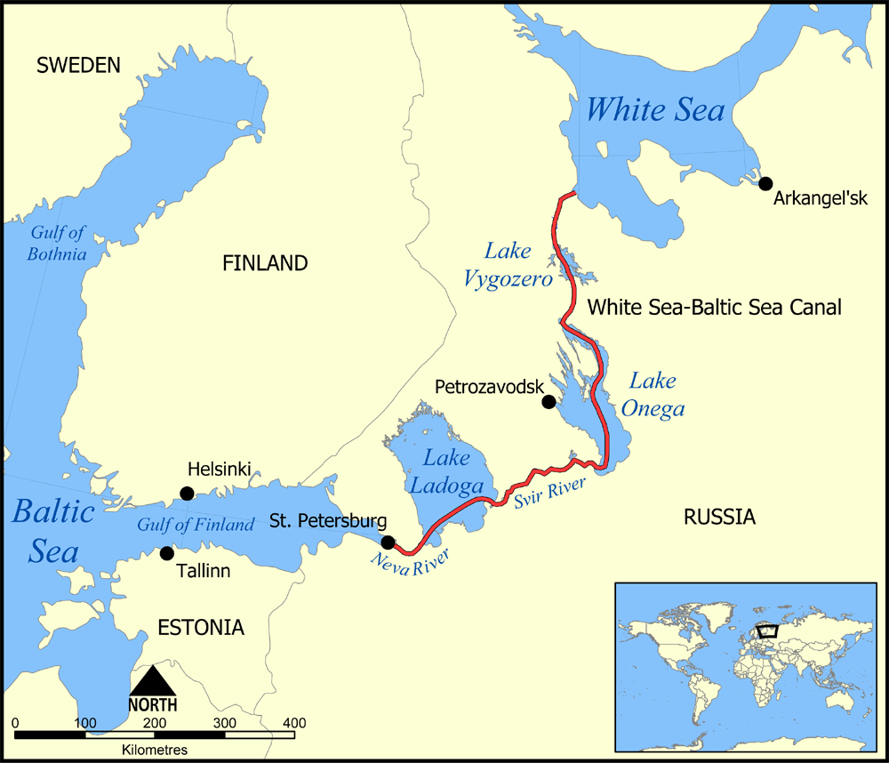
Lake Onega
Lake Onega (/oʊˈnɛɡə/; also known as Onego; Russian: Оне́жское о́зеро, romanized: Onezhskoe ozero, IPA: [ɐˈnʲɛʂskəɪ ˈozʲɪrə]; Finnish: Ääninen, Äänisjärvi; Livvi: Oniegujärvi; Veps: Änine, Änižjärv) is a lake in northwestern Russia, on the territory of the Republic of Karelia, Leningrad Oblast and Vologda Oblast. It belongs to the basin of the Baltic Sea, and is the second-largest lake in Europe after Lake Ladoga, slightly smaller than Lebanon. The lake is fed by about 50 rivers and is drained by the Svir.
There are about 1,650 islands on the lake. They include Kizhi, which hosts a historical complex of 89 Orthodox churches and other wooden structures of the 15th–20th centuries. The complex includes a UNESCO World Heritage Site, Kizhi Pogost. The eastern shores of the lake contain about 1,200 petroglyphs (rock engravings) dated to the 4th–2nd millennia BC, which have also been inscribed as a UNESCO World Heritage Site. The major cities on the lake are Petrozavodsk, Kondopoga and Medvezhyegorsk.
The lake is of glacial-tectonic origin and is a small remnant of a larger body of water which existed in this area during an Ice Age. In geologic terms, the lake is rather young, formed – like almost all lakes in northern Europe – through the carving activity of the inland ice sheets in the latter part of the last ice age, about 12,000 years ago: In the Paleozoic Era (400–300 million years ago) the entire territory of the modern basin of the lake was covered with a shelf sea lying near the ancient, near-equatoric Baltic continent. Sediments at that time – sandstone, sand, clay and limestone – form a 200-metre-thick (660 ft) layer covering the Baltic Shield which consists of granite, gneiss and greenstone. The retreat of the Ice Age glaciers formed the Littorina Sea. Its level was first 7–9 m (23–30 ft) higher than at present, but it gradually lowered, thereby decreasing the sea area and forming several lakes in the Baltic region.
Lake Onega has a surface area of 9,891 km2 (3,819 sq mi) without islands and a volume of 291 km3 (70 cu mi); its length is about 245 km (152 mi) and width about 90 km (56 mi). It is the second largest lake in Europe, and the 17th largest lake by area in the world. Its southern banks are mostly low and continuous, whereas northern banks are rocky and rugged. They contain numerous elongated bays resulting in the lake's outline appearing similar to a giant crayfish. In the northern part lies a large Zaonezhye Peninsula (Заонежье); south of it, is the Big Klimenetsky (Большой Клименецкий) island. To the west of them lies the deep (deeper than 100 m [330 ft]) Greater Onega (Большое Онего) area containing the Kondopozhskaya (Кондопожская губа, depth up to 78 m [256 ft]), Ilem-Gorskaya (42 m [138 ft]), Lizhemskoy (82 m [269 ft]) and Unitskoy (44 m [144 ft]) bays. To the southwest of Greater Onega lies Petrozavodskoye Onego (Петрозаводское Онего) containing the large Petrozavodsk and small Yalguba and Pinguba bays. To the east of Zaonezhye there is a bay, northern part of which is called Povenetsky Bay and the southern part is Zaonezhsky Bay. There, deep sections alternate with banks and islands which split the bay into several parts. The southernmost part of them, Lesser Onega, is 40–50 m (130–160 ft) deep. All the shores there are rocky.
The average depth of the lake is 30 m (98 ft), and the deepest spot of 127 m (417 ft) is located in the northern part. The average depth is 50–60 m (160–200 ft) in the middle and rises to 20–30 m (66–98 ft) in the southern part. The bottom has a very uneven profile, it is covered with silt, and contains numerous trenches of various size and shape in the northern part. The trenches are separated by large shallow banks. Such bottom structure is favorable for fish, and the banks are used for commercial fishing.
The water level is stabilized by the Verhnesvirskaya hydropower plant and varies by only 0.9–1.5 m (2 ft 11 in – 4 ft 11 in) over the year. It rises due to the spring flood which lasts 1+1⁄2 to 2 months. The highest water level is in June–August and the lowest is in March–April. Rivers bring 15.6 km3 (3.7 cu mi) of water per year to the lake, that is up to 74% of the water balance; the rest is provided by precipitation. Most of the lake water (84% or 17.6 km3 [4.2 cu mi] per year) outflows via a single river, Svir, and the remaining 16% evaporates from the lake surface. There are frequent storms more characteristic of a sea than a lake; waves of 2–3 metres (6 ft 7 in – 9 ft 10 in) are not uncommon and may even reach 5 m (16 ft). The lake freezes near the coast and bays in late November and December and around mid-January in its center. Thawing starts in April in the tributaries and reaches the lake in May. Water in the deep parts is clear, with the visibility up to 7–8 m (23–26 ft). In the bays, the visibility may decrease to about a meter. The water is fresh, with a salinity of 35 mg/L. This is relatively low for a lake and is about 1+1⁄2 times lower than in the other large lake of the area, Lake Ladoga.
The maximum surface water temperature is 20–24 °C (68–75 °F) on the open lake and 24–27 °C (75–81 °F) in the bays. The deep waters are much colder, from 2–2.5 °C (36–36 °F) in winter to 4–6 °C (39–43 °F) in summer. Weather is relatively cold, with temperatures below 0 °C (32 °F) for half of the year and average summer temperatures of about 16 °C (61 °F).
The catchment area of 51,540 km2 (19,900 sq mi) drains into the lake via 58 rivers and more than 110 tributaries, including the Shuya, Suna, Vodla, Vytegra and Andoma. The only outgoing Svir, which marks the southern boundary of Karelia, runs from the southwestern shore of Lake Onega to Lake Ladoga and continues as the Neva to the Gulf of Finland.
Hub AI
Lake Onega AI simulator
(@Lake Onega_simulator)
Lake Onega
Lake Onega (/oʊˈnɛɡə/; also known as Onego; Russian: Оне́жское о́зеро, romanized: Onezhskoe ozero, IPA: [ɐˈnʲɛʂskəɪ ˈozʲɪrə]; Finnish: Ääninen, Äänisjärvi; Livvi: Oniegujärvi; Veps: Änine, Änižjärv) is a lake in northwestern Russia, on the territory of the Republic of Karelia, Leningrad Oblast and Vologda Oblast. It belongs to the basin of the Baltic Sea, and is the second-largest lake in Europe after Lake Ladoga, slightly smaller than Lebanon. The lake is fed by about 50 rivers and is drained by the Svir.
There are about 1,650 islands on the lake. They include Kizhi, which hosts a historical complex of 89 Orthodox churches and other wooden structures of the 15th–20th centuries. The complex includes a UNESCO World Heritage Site, Kizhi Pogost. The eastern shores of the lake contain about 1,200 petroglyphs (rock engravings) dated to the 4th–2nd millennia BC, which have also been inscribed as a UNESCO World Heritage Site. The major cities on the lake are Petrozavodsk, Kondopoga and Medvezhyegorsk.
The lake is of glacial-tectonic origin and is a small remnant of a larger body of water which existed in this area during an Ice Age. In geologic terms, the lake is rather young, formed – like almost all lakes in northern Europe – through the carving activity of the inland ice sheets in the latter part of the last ice age, about 12,000 years ago: In the Paleozoic Era (400–300 million years ago) the entire territory of the modern basin of the lake was covered with a shelf sea lying near the ancient, near-equatoric Baltic continent. Sediments at that time – sandstone, sand, clay and limestone – form a 200-metre-thick (660 ft) layer covering the Baltic Shield which consists of granite, gneiss and greenstone. The retreat of the Ice Age glaciers formed the Littorina Sea. Its level was first 7–9 m (23–30 ft) higher than at present, but it gradually lowered, thereby decreasing the sea area and forming several lakes in the Baltic region.
Lake Onega has a surface area of 9,891 km2 (3,819 sq mi) without islands and a volume of 291 km3 (70 cu mi); its length is about 245 km (152 mi) and width about 90 km (56 mi). It is the second largest lake in Europe, and the 17th largest lake by area in the world. Its southern banks are mostly low and continuous, whereas northern banks are rocky and rugged. They contain numerous elongated bays resulting in the lake's outline appearing similar to a giant crayfish. In the northern part lies a large Zaonezhye Peninsula (Заонежье); south of it, is the Big Klimenetsky (Большой Клименецкий) island. To the west of them lies the deep (deeper than 100 m [330 ft]) Greater Onega (Большое Онего) area containing the Kondopozhskaya (Кондопожская губа, depth up to 78 m [256 ft]), Ilem-Gorskaya (42 m [138 ft]), Lizhemskoy (82 m [269 ft]) and Unitskoy (44 m [144 ft]) bays. To the southwest of Greater Onega lies Petrozavodskoye Onego (Петрозаводское Онего) containing the large Petrozavodsk and small Yalguba and Pinguba bays. To the east of Zaonezhye there is a bay, northern part of which is called Povenetsky Bay and the southern part is Zaonezhsky Bay. There, deep sections alternate with banks and islands which split the bay into several parts. The southernmost part of them, Lesser Onega, is 40–50 m (130–160 ft) deep. All the shores there are rocky.
The average depth of the lake is 30 m (98 ft), and the deepest spot of 127 m (417 ft) is located in the northern part. The average depth is 50–60 m (160–200 ft) in the middle and rises to 20–30 m (66–98 ft) in the southern part. The bottom has a very uneven profile, it is covered with silt, and contains numerous trenches of various size and shape in the northern part. The trenches are separated by large shallow banks. Such bottom structure is favorable for fish, and the banks are used for commercial fishing.
The water level is stabilized by the Verhnesvirskaya hydropower plant and varies by only 0.9–1.5 m (2 ft 11 in – 4 ft 11 in) over the year. It rises due to the spring flood which lasts 1+1⁄2 to 2 months. The highest water level is in June–August and the lowest is in March–April. Rivers bring 15.6 km3 (3.7 cu mi) of water per year to the lake, that is up to 74% of the water balance; the rest is provided by precipitation. Most of the lake water (84% or 17.6 km3 [4.2 cu mi] per year) outflows via a single river, Svir, and the remaining 16% evaporates from the lake surface. There are frequent storms more characteristic of a sea than a lake; waves of 2–3 metres (6 ft 7 in – 9 ft 10 in) are not uncommon and may even reach 5 m (16 ft). The lake freezes near the coast and bays in late November and December and around mid-January in its center. Thawing starts in April in the tributaries and reaches the lake in May. Water in the deep parts is clear, with the visibility up to 7–8 m (23–26 ft). In the bays, the visibility may decrease to about a meter. The water is fresh, with a salinity of 35 mg/L. This is relatively low for a lake and is about 1+1⁄2 times lower than in the other large lake of the area, Lake Ladoga.
The maximum surface water temperature is 20–24 °C (68–75 °F) on the open lake and 24–27 °C (75–81 °F) in the bays. The deep waters are much colder, from 2–2.5 °C (36–36 °F) in winter to 4–6 °C (39–43 °F) in summer. Weather is relatively cold, with temperatures below 0 °C (32 °F) for half of the year and average summer temperatures of about 16 °C (61 °F).
The catchment area of 51,540 km2 (19,900 sq mi) drains into the lake via 58 rivers and more than 110 tributaries, including the Shuya, Suna, Vodla, Vytegra and Andoma. The only outgoing Svir, which marks the southern boundary of Karelia, runs from the southwestern shore of Lake Onega to Lake Ladoga and continues as the Neva to the Gulf of Finland.