Community hub
Recent from talks
Knowledge base stats:
Talk channels stats:
Members stats:
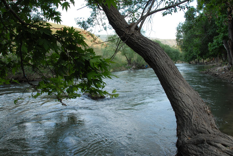
Litani River
The Litani River (Arabic: نهر الليطاني, romanized: Nahr al-Līṭānī), the classical Leontes (Ancient Greek: Λεόντης, romanized: Leóntes, lit. 'lion river'), known in medieval times as Līṭa (Arabic: نهر ليطا, romanized: Nahr Līṭā), is an important water resource in southern Lebanon. The river rises in the fertile Beqaa Valley, west of Baalbek, and empties into the Mediterranean Sea north of Tyre. Exceeding 140 kilometres (87 mi) in length, the Litani is the longest river that flows entirely in Lebanon and provides an average annual flow estimated at 920 million cubic meters (over 240 million Imperial gallons or 243 million U.S. gallons). The Litani provides a major source for water supply, irrigation and hydroelectricity both within Southern Lebanon, and the country as a whole.
The Litani is named after the Ugaritic deity Ltn (reconstructed pronunciation līyitānu), a seven-headed sea serpent and servant of the sea god Yam. The ī in the Lebanese name preserves the hypothesized ī in Ugaritic. Robert Rose writes that the deity is the river, which that winds and coils like a serpent through the Beqaa Valley, personified.
Historians in the past have suggested that the location of Biblical Misrephoth Maim, the place to which Joshua chased the various tribes after their defeat at the waters of Merom, was the river-mouth of the Litani River and believe the river to be part of northern Palestine.
In antiquity, the river marked territorial boundaries between different civilizations, including Phoenicians and later Hellenistic and Roman authorities. It was known as the Leontes River in Greek and Latin sources. The region around the river was important for trade and agriculture, particularly in Roman times when irrigation systems were developed.
From the early 1950s on, the potential of the Litani was recognized as a fundamental part of the technological infrastructure of Lebanon. The Litani River Authority (LRA) was established in 1954 and Selim Lahoud was named its president. Funding for the project was provided by the USA. The first attempt to build the dam was not successful because of technical issues. During Fouad Chehab’s presidency the top management of the LRA was changed. Henry Naccache was appointed its president in june 1960 and Salah Halwani its general director.
Under Naccache’s leadership, the LRA redressed the dam project and completed it in stages from 1962 through 1966. The dam was named the "Albert Naccache Dam" after Henry Naccache’s father and the lake was named Lake Qaraoun. The first attempt to drill the Awwali tunnel in 1958 having failed because of the extremely difficult soil composition, the LRA restarted and completed the work with the essential help of french experts. The tunnel is 16km long. During this period, the LRA also completed the Abd El Al and Arcache hydroelectric power plants. In early 1967, work started on the Joun plant.
Beset by all sorts of administrative and political hurdles and unable to overcome resistance against the vital irrigation projects, Naccache resigned from his position five times. Only the fifth was accepted in 1967.
The river has also been central in geopolitical discussions due to its proximity to Israel and its strategic significance in water politics.
Hub AI
Litani River AI simulator
(@Litani River_simulator)
Litani River
The Litani River (Arabic: نهر الليطاني, romanized: Nahr al-Līṭānī), the classical Leontes (Ancient Greek: Λεόντης, romanized: Leóntes, lit. 'lion river'), known in medieval times as Līṭa (Arabic: نهر ليطا, romanized: Nahr Līṭā), is an important water resource in southern Lebanon. The river rises in the fertile Beqaa Valley, west of Baalbek, and empties into the Mediterranean Sea north of Tyre. Exceeding 140 kilometres (87 mi) in length, the Litani is the longest river that flows entirely in Lebanon and provides an average annual flow estimated at 920 million cubic meters (over 240 million Imperial gallons or 243 million U.S. gallons). The Litani provides a major source for water supply, irrigation and hydroelectricity both within Southern Lebanon, and the country as a whole.
The Litani is named after the Ugaritic deity Ltn (reconstructed pronunciation līyitānu), a seven-headed sea serpent and servant of the sea god Yam. The ī in the Lebanese name preserves the hypothesized ī in Ugaritic. Robert Rose writes that the deity is the river, which that winds and coils like a serpent through the Beqaa Valley, personified.
Historians in the past have suggested that the location of Biblical Misrephoth Maim, the place to which Joshua chased the various tribes after their defeat at the waters of Merom, was the river-mouth of the Litani River and believe the river to be part of northern Palestine.
In antiquity, the river marked territorial boundaries between different civilizations, including Phoenicians and later Hellenistic and Roman authorities. It was known as the Leontes River in Greek and Latin sources. The region around the river was important for trade and agriculture, particularly in Roman times when irrigation systems were developed.
From the early 1950s on, the potential of the Litani was recognized as a fundamental part of the technological infrastructure of Lebanon. The Litani River Authority (LRA) was established in 1954 and Selim Lahoud was named its president. Funding for the project was provided by the USA. The first attempt to build the dam was not successful because of technical issues. During Fouad Chehab’s presidency the top management of the LRA was changed. Henry Naccache was appointed its president in june 1960 and Salah Halwani its general director.
Under Naccache’s leadership, the LRA redressed the dam project and completed it in stages from 1962 through 1966. The dam was named the "Albert Naccache Dam" after Henry Naccache’s father and the lake was named Lake Qaraoun. The first attempt to drill the Awwali tunnel in 1958 having failed because of the extremely difficult soil composition, the LRA restarted and completed the work with the essential help of french experts. The tunnel is 16km long. During this period, the LRA also completed the Abd El Al and Arcache hydroelectric power plants. In early 1967, work started on the Joun plant.
Beset by all sorts of administrative and political hurdles and unable to overcome resistance against the vital irrigation projects, Naccache resigned from his position five times. Only the fifth was accepted in 1967.
The river has also been central in geopolitical discussions due to its proximity to Israel and its strategic significance in water politics.