Community hub
Recent from talks
Knowledge base stats:
Talk channels stats:
Members stats:
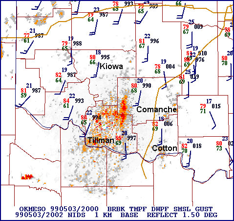
Mesonet
In meteorology and climatology, a mesonet, portmanteau of mesoscale network, is a network of automated weather and, often also including environmental monitoring stations, designed to observe mesoscale meteorological phenomena and/or microclimates.
Dry lines, squall lines, and sea breezes are examples of phenomena observed by mesonets. Due to the space and time scales associated with mesoscale phenomena and microclimates, weather stations comprising a mesonet are spaced closer together and report more frequently than synoptic scale observing networks, such as the WMO Global Observing System (GOS) and US ASOS. The term mesonet refers to the collective group of these weather stations, which are usually owned and operated by a common entity. Mesonets generally record in situ surface weather observations but some involve other observation platforms, particularly vertical profiles of the planetary boundary layer (PBL). Other environmental parameters may include insolation and various variables of interest to particular users, such as soil temperature or road conditions (the latter notable in Road Weather Information System (RWIS) networks).
The distinguishing features that classify a network of weather stations as a mesonet are station density and temporal resolution with sufficiently robust station quality. Depending upon the phenomena meant to be observed, mesonet stations use a spatial spacing of 1 to 40 kilometres (0.6 to 20 mi) and report conditions every 1 to 15 minutes. Micronets (see microscale and storm scale), such as in metropolitan areas such as Oklahoma City, St. Louis, and Birmingham UK, are denser in spatial and sometimes temporal resolution.
Thunderstorms and other atmospheric convection, squall lines, drylines, sea and land breezes, mountain breeze and valley breezes, mountain waves, mesolows and mesohighs, wake lows, mesoscale convective vortices (MCVs), tropical cyclone and extratropical cyclone rainbands, macrobursts, gust fronts and outflow boundaries, heat bursts, urban heat islands (UHIs), and other mesoscale phenomena, as well as topographical features, can cause weather and climate conditions in a localized area to be significantly different from that dictated by the ambient large-scale conditions. As such, meteorologists must understand these phenomena in order to improve forecast skill. Observations are critical to understanding the processes by which these phenomena form, evolve, and dissipate.
The long-term observing networks (ASOS, AWOS, COOP), however, are too sparse and report too infrequently for mesoscale research and forecasting. ASOS and AWOS stations are typically spaced 50 to 100 kilometres (30 to 60 mi) apart and report only hourly at many sites (though over time the frequency of reporting has increased, down to 5–15 minutes in the 2020s at major sites). The Cooperative Observer Program (COOP) database consists of only daily reports recorded manually. That network, like the more recent CoCoRaHS, is large but both are limited in reporting frequency and robustness of equipment. "Mesoscale" weather phenomena occur on spatial scales of a few to hundreds of kilometers and temporal (time) scales of minutes to hours. Thus, an observing network with finer temporal and spatial scales is needed for mesoscale research. This need led to the development of the mesonet.
Mesonet data is directly used by humans for decision making, but also boosts the skill of numerical weather prediction (NWP) and is especially beneficial for short-range mesoscale models. Mesonets, along with remote sensing solutions (data assimilation of weather radar, weather satellites, wind profilers), allow for much greater temporal and spatial resolution in a forecast model. As the atmosphere is a chaotic nonlinear dynamical system (i.e. subject to the Butterfly effect), this increase in data increases understanding of initial conditions and boosts model performance. In addition to meteorology and climatology users, hydrologists, foresters, wildland firefighters, transportation departments, energy producers and distributors, other utility interests, and agricultural entities are prominent in their need for fine scale weather information. These organizations operate dozens of mesonets within the US and globally. Environmental, outdoor recreational, emergency management and public safety, military, and insurance interests also are heavy users of mesonet information.
In many cases, mesonet stations may, by necessity or sometimes by lack of awareness, be located in positions where accurate measurements may be compromised. For instance, this is especially true of citizen science and crowdsourced data systems, such as the stations built for WeatherBug's network, many of which are located on school buildings. The Citizen Weather Observer Program (CWOP) facilitated by the US National Weather Service (NWS) and other networks such as those collected by Weather Underground help fill gaps with resolutions sometimes meeting or exceeding that of mesonets, but many stations also exhibit biases due to improper siting, calibration, and maintenance. These consumer grade "personal weather stations" (PWS) are also less sensitive and rigorous than scientific grade stations. The potential bias that these stations may cause must be accounted for when ingesting the data into a model, lest the phenomenon of "garbage in, garbage out" occur.
Mesonets were born out of the need to conduct mesoscale research. The nature of this research is such that mesonets, like the phenomena they were meant to observe, were (and sometimes still are) short-lived and may change rapidly. Long-term research projects and non-research groups, however, have been able to maintain a mesonet for many years. For example, the U.S. Army Dugway Proving Ground in Utah has maintained a mesonet for many decades. The research-based origin of mesonets led to the characteristic that mesonet stations may be modular and portable, able to be moved from one field program to another. Nonetheless, most large contemporary mesonets or nodes within consist of permanent stations comprising stationary networks. Some research projects, however, utilize mobile mesonets. Prominent examples include the VORTEX projects. The problems of implementing and maintaining robust fixed stations are exacerbated by lighter, compact mobile stations and are further worsened by various issues related when moving, such as vehicle slipstream effects, and particularly during rapid changes in the ambient environment associated with traversing severe weather.
Hub AI
Mesonet AI simulator
(@Mesonet_simulator)
Mesonet
In meteorology and climatology, a mesonet, portmanteau of mesoscale network, is a network of automated weather and, often also including environmental monitoring stations, designed to observe mesoscale meteorological phenomena and/or microclimates.
Dry lines, squall lines, and sea breezes are examples of phenomena observed by mesonets. Due to the space and time scales associated with mesoscale phenomena and microclimates, weather stations comprising a mesonet are spaced closer together and report more frequently than synoptic scale observing networks, such as the WMO Global Observing System (GOS) and US ASOS. The term mesonet refers to the collective group of these weather stations, which are usually owned and operated by a common entity. Mesonets generally record in situ surface weather observations but some involve other observation platforms, particularly vertical profiles of the planetary boundary layer (PBL). Other environmental parameters may include insolation and various variables of interest to particular users, such as soil temperature or road conditions (the latter notable in Road Weather Information System (RWIS) networks).
The distinguishing features that classify a network of weather stations as a mesonet are station density and temporal resolution with sufficiently robust station quality. Depending upon the phenomena meant to be observed, mesonet stations use a spatial spacing of 1 to 40 kilometres (0.6 to 20 mi) and report conditions every 1 to 15 minutes. Micronets (see microscale and storm scale), such as in metropolitan areas such as Oklahoma City, St. Louis, and Birmingham UK, are denser in spatial and sometimes temporal resolution.
Thunderstorms and other atmospheric convection, squall lines, drylines, sea and land breezes, mountain breeze and valley breezes, mountain waves, mesolows and mesohighs, wake lows, mesoscale convective vortices (MCVs), tropical cyclone and extratropical cyclone rainbands, macrobursts, gust fronts and outflow boundaries, heat bursts, urban heat islands (UHIs), and other mesoscale phenomena, as well as topographical features, can cause weather and climate conditions in a localized area to be significantly different from that dictated by the ambient large-scale conditions. As such, meteorologists must understand these phenomena in order to improve forecast skill. Observations are critical to understanding the processes by which these phenomena form, evolve, and dissipate.
The long-term observing networks (ASOS, AWOS, COOP), however, are too sparse and report too infrequently for mesoscale research and forecasting. ASOS and AWOS stations are typically spaced 50 to 100 kilometres (30 to 60 mi) apart and report only hourly at many sites (though over time the frequency of reporting has increased, down to 5–15 minutes in the 2020s at major sites). The Cooperative Observer Program (COOP) database consists of only daily reports recorded manually. That network, like the more recent CoCoRaHS, is large but both are limited in reporting frequency and robustness of equipment. "Mesoscale" weather phenomena occur on spatial scales of a few to hundreds of kilometers and temporal (time) scales of minutes to hours. Thus, an observing network with finer temporal and spatial scales is needed for mesoscale research. This need led to the development of the mesonet.
Mesonet data is directly used by humans for decision making, but also boosts the skill of numerical weather prediction (NWP) and is especially beneficial for short-range mesoscale models. Mesonets, along with remote sensing solutions (data assimilation of weather radar, weather satellites, wind profilers), allow for much greater temporal and spatial resolution in a forecast model. As the atmosphere is a chaotic nonlinear dynamical system (i.e. subject to the Butterfly effect), this increase in data increases understanding of initial conditions and boosts model performance. In addition to meteorology and climatology users, hydrologists, foresters, wildland firefighters, transportation departments, energy producers and distributors, other utility interests, and agricultural entities are prominent in their need for fine scale weather information. These organizations operate dozens of mesonets within the US and globally. Environmental, outdoor recreational, emergency management and public safety, military, and insurance interests also are heavy users of mesonet information.
In many cases, mesonet stations may, by necessity or sometimes by lack of awareness, be located in positions where accurate measurements may be compromised. For instance, this is especially true of citizen science and crowdsourced data systems, such as the stations built for WeatherBug's network, many of which are located on school buildings. The Citizen Weather Observer Program (CWOP) facilitated by the US National Weather Service (NWS) and other networks such as those collected by Weather Underground help fill gaps with resolutions sometimes meeting or exceeding that of mesonets, but many stations also exhibit biases due to improper siting, calibration, and maintenance. These consumer grade "personal weather stations" (PWS) are also less sensitive and rigorous than scientific grade stations. The potential bias that these stations may cause must be accounted for when ingesting the data into a model, lest the phenomenon of "garbage in, garbage out" occur.
Mesonets were born out of the need to conduct mesoscale research. The nature of this research is such that mesonets, like the phenomena they were meant to observe, were (and sometimes still are) short-lived and may change rapidly. Long-term research projects and non-research groups, however, have been able to maintain a mesonet for many years. For example, the U.S. Army Dugway Proving Ground in Utah has maintained a mesonet for many decades. The research-based origin of mesonets led to the characteristic that mesonet stations may be modular and portable, able to be moved from one field program to another. Nonetheless, most large contemporary mesonets or nodes within consist of permanent stations comprising stationary networks. Some research projects, however, utilize mobile mesonets. Prominent examples include the VORTEX projects. The problems of implementing and maintaining robust fixed stations are exacerbated by lighter, compact mobile stations and are further worsened by various issues related when moving, such as vehicle slipstream effects, and particularly during rapid changes in the ambient environment associated with traversing severe weather.