Hubbry Logo
VORTEX projectsVORTEX projectsMain
Open search
VORTEX projects
Community hub
VORTEX projects
logo
8 pages, 0 posts
0 subscribers
Be the first to start a discussion here.
VORTEX projects
VORTEX projects
from Wikipedia
NSSL mobile mesonet vehicles of the first Project VORTEX, equipped with surface measurement equipment.

The Verification of the Origins of Rotation in Tornadoes Experiment (or VORTEX) are field experiments that study tornadoes. VORTEX1 was the first time scientists completely researched the entire evolution of a tornado with an array of instrumentation, enabling a greater understanding of the processes involved with tornadogenesis. A violent tornado near Union City, Oklahoma was documented in its entirety by chasers of the Tornado Intercept Project (TIP) in 1973. Their visual observations led to advancement in understanding of tornado structure and life cycles.[1]

VORTEX2 used enhanced technology that allowed scientists to improve forecasting capabilities and improve lead time on advanced warnings to residents. VORTEX2 sought to reveal how tornadoes form, how long they last and why they last that long, and what causes them to dissipate.[2]

VORTEX1 and VORTEX2 was based on the use of large fleets of instrumented vehicles that ran on land, as well as aircraft and mobile radars. Important work on developing and coordinating mobile mesonets came from these field projects.[3][2] Analysis of data collected in subsequent years led to significant advancement in understanding of supercell and tornado morphology and dynamics. The field research phase of the VORTEX2 project concluded on July 6, 2010.[4]

VORTEX1

[edit]
VORTEX1
Project Vortex. The Dimmitt tornado. National Severe Storms Laboratory (NSSL)
Date1994 and 1995
LocationTornado Alley
Also known asVerification of the Origins of Rotation in Tornadoes Experiment 1
OutcomeDocumented an entire tornado, which, in conjunction with deployment of the NEXRAD system, helped the National Weather Service (NWS) to provide severe weather warnings with a thirteen-minute lead time, and reduce false alarms by ten percent.
Websitehttp://vortex2.org/

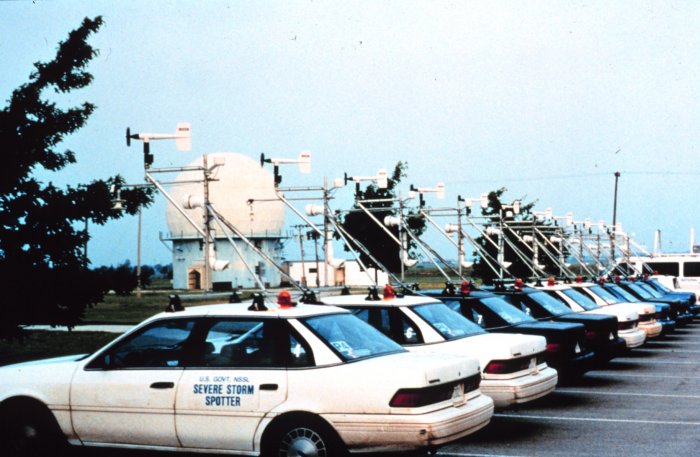
The VORTEX1 project sought to understand how a tornado is produced by deploying tornado experts in around 18 vehicles that were equipped with customized instruments used to measure and analyze the weather around a tornado. As noted aircraft and radar resources were also deployed for such measurements. The project directors were also interested in why some supercells, or mesocyclones within such storms, produce tornadoes while others do not. It also sought to determine why some supercells form violent tornadoes versus weak tornadoes.

The original project took place in 1994 and 1995. Several smaller studies, such as SUB-VORTEX and VORTEX-99, were conducted from 1996 to 2008.[5] VORTEX1 documented the entire life cycle of a tornado, for the first time measuring it by significant instrumentation for the entire event.[6] Severe weather warnings improved after the research collected from VORTEX1, and many believe that VORTEX1 contributed to this improvement.[7]

“An important finding from the original VORTEX experiment was that the factors responsible for causing tornadoes happen on smaller time and space scales than scientists had thought. New advances will allow for a more detailed sampling of a storm's wind, temperature, and moisture environment, and lead to a better understanding of why tornadoes form –-and how they can be more accurately predicted,” said Stephan Nelson, NSF program director for physical and dynamic meteorology.[8][9]

VORTEX had the capability to fly Doppler weather radar above the tornado approximately every five minutes.[10]

VORTEX research helped the National Weather Service (NWS) to provide tornado warnings to residents with a lead time of 13 minutes.[11] A federal research meteorologist, Don Burgess, estimates that the "false alarms" pertaining to severe weather by the National Weather Service have declined by 10 percent.[12]

The movie Twister was at least partially inspired by the VORTEX project.[13]

VORTEX2

[edit]
VORTEX2
Date10 May 2009 – 13 June 2009 and 1 May 2010 – 15 June 2010
LocationTornado Alley
Also known asVerification of the Origins of Rotation in Tornadoes Experiment 2
Websitehttp://vortex2.org/
VORTEX2 field command vehicle with tornado in sight. Wyoming, LaGrange. 2009

VORTEX2 was an expanded second VORTEX project, with field phases from 10 May until 13 June 2009 and 1 May until 15 June 2010. VORTEX2's goals were studying why some thunderstorms produce tornadoes while others do not, and learning about tornado structure, in order to make more accurate tornado forecasts and warnings with longer lead time.[14] VORTEX2 was by far the largest and most ambitious tornado study ever with over 100 scientific participants from many different universities and research laboratories.

"We still do not completely understand the processes that lead to tornado formation and shape its development. We hope that VORTEX2 will provide the data we need to learn more about the development of tornadoes and in time help forecasters give people more advance warning before a tornado strikes," said Roger Wakimoto, director of the Earth Observing Laboratory (EOL) at the National Center for Atmospheric Research (NCAR) and a principal investigator for VORTEX2.[11]

"Then you can get first responders to be better prepared—police, fire, medical personnel, even power companies. Now, that's not even remotely possible," said Stephan P. Nelson, a program director in the atmospheric sciences division of the National Science Foundation (NSF).[10]

Joshua Wurman, president of the Center for Severe Weather Research (CSWR) in Boulder, Colorado proposes, "if we can increase that lead time from 13 minutes to half an hour, then the average person at home could do something different. Maybe they can seek a community shelter instead of just going into their bathtub. Maybe they can get their family to better safety if we can give them a longer warning and a more precise warning."[12]

VORTEX2 deployed 50 vehicles customized with mobile radar, including the Doppler On Wheels (DOW) radars, SMART radars, the NOXP radar, a fleet of instrumented vehicles, unmanned aerial vehicles (UAVs), deployable instrument arrays called Sticknet and Podnet, and mobile weather balloon launching equipment. More than 100 scientists and crew researched tornadoes and supercell thunderstorms in the "Tornado Alley" region of the United States' Great Plains between Texas and Minnesota. A number of institutions and countries were involved in the US$11.9 million project, including: the US National Oceanic and Atmospheric Administration (NOAA) and its National Weather Service and the Storm Prediction Center (SPC) therein, the Australian Bureau of Meteorology (BOM), Finland, Italy, the Netherlands, the United Kingdom, Environment Canada, and universities across the United States and elsewhere.

The project included DOW3, DOW6, DOW7, Rapid-Scan DOW, SMART-RADARs, NOXP, UMASS-X, UMASS-W, CIRPAS and TIV 2 for their mobile radar contingent. The Doppler on Wheels were supplied by the Center for Severe Weather Research, and the SMART-Radars from the University of Oklahoma (OU). The National Severe Storms Laboratory (NSSL) supplied the NOXP radar, as well as several other radar units from the University of Massachusetts Amherst, the Office of Naval Research (ONR), and Texas Tech University (TTU). NSSL, CSWR, and Environment Canada supplied mobile mesonet fleets. Mobile radiosonde launching vehicles were provided by NSSL, NCAR, and the State University of New York at Oswego (SUNY Oswego). There were quite a few other deployable state-of-the-art instrumentation, such as Sticknets from TTU, tornado PODS from CSWR, and four disdrometers from University of Colorado CU, and the University of Illinois at Urbana-Champaign (UIUC).[15][16]

VORTEX2 technology allowed trucks with radar to be placed in and near tornadic storms and allowed continuous observations of the tornadic activity. Howard Bluestein, a meteorology professor at the University of Oklahoma said, "We will be able to distinguish between rain, hail, dust, debris, flying cows."[10]

Additionally, photogrammetry teams, damage survey teams, unmanned aircraft, and weather balloon launching vans helped to surround the tornadoes and thunderstorms.[15][16] The equipment amassed enabled three-dimensional data sets of the storms to be collected with radars and other instruments every 75 seconds (more frequently for some individual instruments), and resolution of the tornado and tornadic storm cells as close as 200 feet (61 m).[11][17]

Scientists met May 10 and held a class to teach the crews how to launch the tornado pods, which would have to be released within 45 seconds of notification.[18] VORTEX2 was equipped with 12 tornado PODS, instruments mounted onto 1 meter (3.3 ft) towers that measure wind velocity (i.e. speed and direction). The aim was that some of the measurements would be taken in the center of the tornado.[19] Once the pods are deployed, the teams repeat the process at the next location until finally the teams return to the south of the tornado to retrieve the pods with the recorded data. The process is repeated. This takes place within 2 miles (3.2 km), or 4 minutes away from the tornado itself.[18]

The team had twenty-four 2-meter (6.6 ft)-high portable Sticknets, which can be set up at various locations around tornado storm cells to measure wind fields, provide atmospheric readings, and record acoustically the hail and precipitation.[17][19]

Scientists are still seeking to refine understanding of which supercell thunderstorms that form mesocyclones will eventually produce tornadoes, and by which processes, storm-scale interactions, and within which atmospheric environments.[10]

A Doppler on Wheels radar loop of the tornado intercepted on June 5.

Updates on the progress of the project were posted on the VORTEX2 home page. The scientists also started a blog of live reports.[20]

"Even though this field phase seems to be the most spectacular and seems like it's a lot of work, by far the majority of what we're doing is when we go back to our labs, when we work with each other, when we work with our students to try to figure out just what is it that we've collected," Wurman said. "It's going to take years to digest this data and to really get the benefit of this."

Penn State University featured the public release of the initial scientific findings in the fall.[12]

The forecasters were determining the best probability of sighting a tornado. As the trucks traveled to Clinton, Oklahoma from Childress, Texas, they found mammatus clouds, and lightning at sundown on May 13, 2009.[21]

The project encountered its first tornado on the afternoon of June 5 when they successfully intercepted a tornado in southern Goshen County, Wyoming, which lasted for approximately 25 minutes. One of their vehicles, Probe 1, suffered hail damage during the intercept. Later that evening, embedded Weather Channel (TWC) reporter Mike Bettes reported that elements of VORTEX2 had intercepted a second tornado in Nebraska. Placement of the armada for this tornado was nearly ideal. It was surrounded for its entire life cycle, making it the most thoroughly observed tornado in history.[citation needed]

Partial list of scientists and crew

[edit]
VORTEX2 principal investigators plot the next step from the Field Command Vehicle (FCV). Left to right, Chris Weiss (TTU), Joshua Wurman (CSWR), Yvette Richardson (PSU), David Dowell (NCAR), Howard Bluestein (OU), and Lou Wicker (NSSL).

The complete team comprises about 50 scientists and is supplemented by students. A complete listing of principal investigators (PIs) is at http://vortex2.org/ Archived 2019-07-31 at the Wayback Machine. An alphabetical partial listing of VORTEX2 scientists and crew:

Smaller projects

[edit]

Other smaller field projects include the previously mentioned SUB-VORTEX (1997–98) and VORTEX-99 (1999),[5][25] and VORTEX-Southeast (VORTEX-SE) (2016-2019).[26]

See also

[edit]

References

[edit]
[edit]
Revisions and contributorsEdit on WikipediaRead on Wikipedia
from Grokipedia
The VORTEX projects, formally known as the Verification of the Origins of Rotation in Tornadoes Experiment, constitute a series of large-scale field campaigns led by the National Oceanic and Atmospheric Administration's (NOAA) National Severe Storms Laboratory (NSSL) in collaboration with academic and research institutions to study the environmental conditions, formation processes, and physical dynamics of tornadoes. These initiatives seek to address fundamental questions about — the development of leading to tornadoes—while enhancing predictive models, accuracy, and warning systems to mitigate societal impacts. Initiated in the mid-1990s, the projects have evolved through multiple phases, incorporating advanced observational technologies such as mobile Doppler radars, research aircraft, and ground-based sensor networks to collect unprecedented datasets from thunderstorms across the . The inaugural phase, VORTEX1, operated from 1994 to 1995 across the central and southern U.S. Plains, targeting regions with frequent tornado activity and favorable terrain for observation. It employed NOAA's P-3 and NCAR Electra aircraft, along with mobile radars and mesonets, to examine storm-scale generation, tornado structure, and debris patterns, yielding foundational insights into how environmental factors influence tornadic supercells. This effort marked a significant advancement in by providing the first intensive, multi-platform observations of pre-tornadic storm evolution. Building on these results, VORTEX2 (2009–2010) represented the largest and most ambitious tornado field program to date, involving over 100 scientists and deploying 10 mobile radars and 70 instruments across more than 10,000 miles in the Plains. Focused on thunderstorms, it captured detailed data on 11 such storms, including the most comprehensively observed in history, from 20 minutes before formation through dissipation, which has informed cloud-resolving models for short-term "warn-on-forecast" systems. Subsequent efforts, including VORTEX Southeast (VORTEX-SE) from 2016 to 2019 and its nationwide expansion as VORTEX USA starting in 2021, shifted emphasis to the southeastern U.S., where tornadoes often occur at night, in complex terrain, and amid higher population densities, increasing vulnerability. These phases integrated components to study warning dissemination and sheltering behaviors, alongside meteorological observations using unmanned aircraft systems (UAS), lightning mapping, and rapid-response teams like the Propagation, Evolution, and Rotation in Linear Storms (PERiLS). Key outcomes across the VORTEX series include refined understandings of low-level wind shear's role in rotation intensification and improved strategies for integrating research data into operational weather services, ultimately contributing to reduced tornado-related fatalities through better preparedness.

Overview

Definition and Objectives

The Verification of the Origins of Rotation in Tornadoes Experiment (VORTEX) comprises a series of multi-year, multi-institutional field programs led by the National Oceanic and Atmospheric Administration's (NOAA) National Severe Storms Laboratory (NSSL), deploying mobile radars, soundings, and other observational tools to study thunderstorms and in real-time. These initiatives focus on gathering high-resolution on dynamics to elucidate the physical processes underlying development, with deployments targeting regions prone to such as the and Southeast . The primary objectives of VORTEX projects center on investigating the mechanisms of —the process by which in a intensifies into a —including the roles of environmental factors that influence , path, and likelihood of formation. Key among these is the examination of interactions between storm-scale processes, such as the rear-flank downdraft (RFD)—a descending current of cool air on the storm's rear flank that can generate baroclinic —and meso-scale environmental conditions like low-level , which provides the horizontal necessary for vertical amplification near the surface. By documenting the full lifecycle of tornadoes, from precursor rotation to dissipation, the projects aim to improve forecasting models and warning systems, ultimately reducing societal risks from these hazards. Over time, VORTEX objectives have evolved from an initial emphasis in the on fundamental physics of tornado formation in classic Plains environments to broader investigations in later phases addressing regional variations, such as the Southeast's humid, forested terrain and nocturnal storms, and their implications for public safety and warning dissemination. This progression reflects advances in technology and a growing recognition of diverse tornado climatologies across the U.S., though core aims remain tied to enhancing predictive understanding of supercell- interactions.

Historical Development

The VORTEX (Verification of the Origins of Rotation in Tornadoes Experiment) projects originated in the early 1990s at NOAA's National Severe Storms Laboratory (NSSL), driven by persistent gaps in understanding tornado predictability following extensive thunderstorm research during the 1980s. These earlier studies had advanced knowledge of dynamics but left key questions about —the processes leading to tornado formation—unresolved, prompting NSSL scientists to propose targeted field experiments to bridge these deficiencies. The initial planning and proposal for VORTEX emerged around 1990–1993, culminating in the launch of VORTEX1 in 1994 as a collaborative effort funded primarily by the (NSF) and NOAA. This foundational phase emphasized direct observations of environments to enhance tornado forecasting accuracy. Key milestones in the evolution of VORTEX projects reflect a progression from focused initial campaigns to expansive, multi-regional initiatives. VORTEX1 operated over 1994–1995, deploying mobile radars and aircraft for the first comprehensive documentation of tornado evolution, followed by smaller-scale efforts like SUB-VORTEX in 1997 and VORTEX-99 in 1999, which captured data during significant events such as the F5 tornado. The program scaled dramatically with VORTEX2 in 2009–2010, the largest field study to date, involving over 100 personnel and advanced instrumentation across the . Subsequent developments addressed regional variations, with VORTEX-Southeast (VORTEX-SE) commencing in 2016 to examine tornadoes in the humid Southeast U.S., and VORTEX-USA launching in as an ongoing, nationwide program integrating diverse storm environments. Funding has consistently come from NSF and NOAA, supporting iterative expansions in scope and technology. Institutionally, NSSL has served as the core hub for VORTEX projects, fostering collaborations with the for radar development, the (NCAR) for aircraft operations, and other universities such as UCLA. Early efforts were predominantly meteorological, but later phases, starting with VORTEX-SE, incorporated social scientists to study warning communication and community responses, alongside international partners for broader expertise. These partnerships have evolved to include interdisciplinary teams, enhancing the program's ability to translate research into operational improvements. The primary motivations for VORTEX projects have centered on advancing efficacy, aiming to extend lead times from typical minutes to potentially hours while minimizing false alarms that erode . This drive addresses regional disparities in U.S. tornado activity, such as the contrasting environments of the traditional "" versus the forested, high-population Southeast, where nocturnal and low-topped storms pose unique forecasting challenges. By filling these knowledge gaps, VORTEX initiatives seek to reduce societal impacts through better prediction of formation and intensity.

Early Major Campaigns

VORTEX1

The Verification of the Origins of Rotation in Tornadoes Experiment (VORTEX1) was the inaugural large-scale field campaign dedicated to understanding tornado formation processes within supercell thunderstorms. Conducted over two spring seasons to maximize opportunities for observing severe weather, the project aligned with broader VORTEX goals of resolving the physical mechanisms of tornadogenesis through targeted observations. Operations spanned from April 1 to June 15 in both 1994 and 1995, focusing on the Great Plains region, particularly Oklahoma, Kansas, and Texas, where supercell activity is prevalent. The campaign involved several mobile Doppler radars and multiple research teams from institutions including the National Severe Storms Laboratory (NSSL), National Center for Atmospheric Research (NCAR), and various universities, enabling coordinated data collection across diverse storm environments. Deployment emphasized a hybrid network of fixed and mobile observing platforms to intercept pre-tornadic supercells at close range. Fixed sites provided baseline data, while mobile units—such as mesonets, sounding systems, and trucks—were positioned dynamically around target storms to capture evolving atmospheric structures. This strategy marked the first extensive application of dual-Doppler analysis during field operations, synthesizing data from paired to reconstruct three-dimensional wind fields and reveal internal storm dynamics. platforms, including the NOAA WP-3D and NCAR Electra Doppler radar , complemented ground-based efforts by probing storm updrafts and downdrafts from aloft. Key operations yielded high-resolution observations of multiple tornado events, including interceptions of 10 tornadoes across the two years. A standout case was the F3 tornado near Dimmitt, Texas, on June 2, 1995, which became one of the most comprehensively documented tornadoes of its era due to multi-instrument coverage. Researchers captured the full lifecycle of several events, from mesocyclone development and intensification to vortex formation, touchdown, and dissipation, using synchronized radar scans, in-situ probes, and visual documentation. Initial analyses from VORTEX1 data illuminated critical processes in tornado maintenance, particularly the rear-flank downdraft (RFD)'s role in delivering cooler, drier air to the tornado base, which enhances low-level convergence and updrafts. This RFD intrusion was observed to modulate gradients, influencing vortex stability during . Additionally, the campaign advanced insights into vortex stretching, a key amplification mechanism for rotation, through examination of the equation's horizontal component: ζ=vxuy\zeta = \frac{\partial v}{\partial x} - \frac{\partial u}{\partial y} where ζ\zeta represents vertical , with emphasis on its vertical variation to quantify effects in the low levels. These findings established foundational evidence for how environmental interactions drive vertical in supercells.

SUB-VORTEX and VORTEX-99

SUB-VORTEX, conducted from 1997 to 1998 as a smaller-scale extension of the original VORTEX project, focused on observing sub-vortices within tornadoes using high-resolution mobile radars deployed across the southern High Plains. The initiative employed fewer vehicles than its predecessor for a tighter emphasis on fine-scale structures, with operations spanning 10 missions in May-June 1997 alone across , , , and , followed by SubVORTEX-RFD in 1998, which targeted rear-flank downdraft dynamics. Key instruments included the Doppler-on-Wheels (DOW) mobile radars and a mobile , enabling the first dual-Doppler observations of a during the Keifer, , event on May 26, 1997. These efforts, involving compact teams of approximately 10-15 personnel, integrated GPS sondes for profiling to capture thermodynamic and kinematic data near tornadic circulations. The project documented 3-5 tornadoes ranging from weak to strong, including the Keifer case, where subvortices were resolved at scales below 100 , highlighting their role in and dispersing tornadic through , localized updrafts and shear. Specific findings underscored how multiple subvortices contribute to irregular damage patterns by concentrating in narrow, high-wind corridors within the parent vortex. Building on SUB-VORTEX methodologies, VORTEX-99 operated during the spring and early summer of 1999 as a joint effort between NOAA's National Severe Storms Laboratory (NSSL) and the , emphasizing the evolution of low-level in thunderstorms. With small teams of 10-15 personnel, the project targeted 5-10 , deploying mobile for near-surface measurements, video documentation for visual correlation of storm features, and GPS sondes to profile near-surface winds and stability. Operations peaked during the May 3, 1999, outbreak, where mobile mesonet vehicles encircled key storm regions like the hook echo and rear-flank downdraft, capturing data on 12 tornadoes from two , including weak, moderate, and violent examples. These observations revealed rapid mesocyclone intensification driven by tilting of streamwise into vertical axes at low levels. A pivotal contribution from both projects was evidence of horizontal vorticity generation through baroclinicity in the forward-flank downdraft (FFD), where density gradients along the gust front produce solenoidal torque. This process, quantified in the vorticity budget equation as the baroclinic generation term, DωDt=(ω)vω(v)+1ρ3(ρ×p)+×F,\frac{D \boldsymbol{\omega}}{Dt} = (\boldsymbol{\omega} \cdot \nabla) \mathbf{v} - \boldsymbol{\omega} (\nabla \cdot \mathbf{v}) + \frac{1}{\rho^3} (\nabla \rho \times \nabla p) + \nabla \times \mathbf{F}, where the term 1ρ3(ρ×p)\frac{1}{\rho^3} (\nabla \rho \times \nabla p) represents the due to misaligned and gradients, was observed to enhance low-level when tilted upward by the . In SUB-VORTEX data from the Keifer tornado, this mechanism explained subvortex persistence amid debris-laden flows, while VORTEX-99 intercepts during the May 3 event demonstrated its role in sustaining multiple weak-to-strong cycles within evolving mesocyclones. Such insights refined understanding of how FFD baroclinicity contributes to without relying on exhaustive listings of all intercepts.

VORTEX2

Project Design and Deployment

VORTEX2 marked a pivotal evolution in tornado research campaigns through its emphasis on scalable, adaptive observation strategies tailored to the transient nature of supercell thunderstorms. The project's design prioritized multi-platform integration to address gaps in understanding tornadogenesis and storm structure, drawing on lessons from prior initiatives while deploying cutting-edge mobile technologies across expansive regions prone to severe weather. This comprehensive setup enabled simultaneous measurements at storm, mesocyclone, and tornado scales, fostering a holistic view of atmospheric processes. The campaign unfolded over two field phases in spring 2009 and 2010, from May 10 to June 13, 2009, and May 1 to June 15, 2010, totaling around 100 days of deployment readiness spanning the , including the from the Dakotas southward to and westward from to and , across a domain of approximately 1.2 million square kilometers. This ambitious scale mobilized about 50 specialized vehicles, 11 mobile radars, unmanned aerial systems for targeted sampling, and over 110 personnel, with more than 80 students participating in hands-on operations. Central to the design were innovations like the "swarm" strategy, which coordinated rapid repositioning of observation platforms to encircle evolving storms, supported by the Shared Autonomous Nowcast Strategy and Information (SASSI) software for real-time, decentralized tactical decisions. The integration of Ka-band rapid-scan radars from allowed for high-temporal-resolution updates, approximately every 30 seconds, to resolve fine-scale tornado dynamics. Additionally, StickNet probe arrays—24 deployable, tripod-mounted sensors—provided in-situ thermodynamic profiles, including , , and , by forming linear arrays spaced 1–5 km apart within targeted storm inflow regions. Logistical coordination emphasized dissemination via integrated mobile networks and command interfaces, enabling on-the-fly adjustments to forecasts and intercept paths. The effort united collaborators from over 15 institutions, including universities and national laboratories across more than five countries, under a steering committee for unified planning. Funded at about $11.9 million primarily by the and , the nomadic operations sustained roughly 100 personnel with daily mobile accommodations and support logistics. Instrumentation featured dual-polarization s for distinguishing hydrometeor types and precipitation evolution, notably the C-band Shared Mobile Atmospheric Research and Teaching (SMART-R2), the NOAA X-band (NOXP), and the University of Massachusetts X-band polarimetric (UMASS XPOL). Upper-level wind structures were probed using four Mobile GPS Advanced Upper-Air Systems (MGAUS), which launched over 250 radiosondes to profile winds and aloft in supercells. These elements, alongside mobile mesonets and deployable environmental pods, created a robust, adaptable network optimized for capturing the precursors and evolution of rotation in severe storms.

Key Operations and Data Collection

The VORTEX2 field campaign unfolded over two intensive operational phases spanning approximately 40–45 days each: from May 10 to June 13, 2009, and May 1 to June 15, 2010, focusing on severe weather outbreaks within across the central from the Dakotas southward to . These periods were strategically timed to coincide with peak tornadic activity, with daily deployments guided by adaptive sampling strategies informed by real-time (NWS) forecasts and model guidance to reposition the fleet of over 40 vehicles, including mobile radars and mesonets, toward anticipated development. This nomadic approach allowed for flexible targeting of high-risk regions, such as eastern Colorado, , , , , and , maximizing encounters with evolving storm systems. Key intercepts during these phases included observations of approximately 30 supercells, including about 20 that produced documented across multiple scales using coordinated mobile platforms. Among the most significant was the June 5, 2009, EF2 in , which generated a multi-vortex structure and was surrounded by an array of instruments for its full lifecycle, offering unprecedented multi-platform views of tornado genesis comparable in observational intensity to the 1999 2.6-mile-wide Bridge Creek-Moore EF5 event. Other notable cases involved short-lived weak in 2010, such as the near Booker, , where rapid deployments captured near-ground wind fields during formation and intensification. The campaign amassed approximately 30 terabytes of raw data, encompassing radar volumes, in situ thermodynamic profiles, and visual documentation from diverse sensors deployed within 1-10 km of targets. Central to this dataset were high-resolution time-series of low-level rotation, derived from tangential velocity profiles vtv_t computed using radial velocity components from dual-Doppler mobile s, enabling detailed mapping of mesocyclone-to-tornado transitions at sub-100 m resolution. Operations encountered environmental challenges, including dust storms that obscured visibility for photographic and visual , particularly in the arid western portions of the target area during dry outbreaks. To address artifacts such as ground clutter and partial beam blockage from or , teams implemented real-time quality control protocols, including on-site and adaptive scanning strategies to ensure usable observations amid variable conditions.

Regional and Ongoing Initiatives

VORTEX-Southeast

The VORTEX-Southeast (VORTEX-SE) project conducted field phases in 2016, 2018, and 2019, targeting tornado-prone regions in , , and to investigate in the humid subtropical environment known as . This initiative adapted methodologies from prior Plains-focused VORTEX campaigns to address the distinct challenges of Southeast U.S. tornadoes, which often occur in high-shear, low-CAPE (HSLC) conditions and contribute disproportionately to national tornado fatalities despite lower overall frequency. The project emphasized environmental factors influencing tornado formation, such as terrain interactions and moisture gradients, while integrating interdisciplinary approaches to enhance and risk mitigation. Key adaptations in VORTEX-SE included a strong focus on nocturnal and cool-season storms, which are prevalent in the Southeast and pose unique observational difficulties due to limited daylight and complex nocturnal boundary layers. Researchers deployed a mobile consisting of vehicle-based sensors to capture fine-scale gradients and thermodynamic profiles critical to HSLC initiation. Additionally, the project incorporated components, conducting surveys and interviews to assess public response to warnings, particularly in densely populated areas with varying socioeconomic vulnerabilities, aiming to inform better communication strategies for nighttime events. During the field phases, VORTEX-SE teams achieved multiple targeted intercepts of quasi-linear convective systems (QLCS), a dominant mode for Southeast tornadoes, allowing for in-situ measurements of storm-scale processes. A notable operational tool was the deployment of Phased Array Radar (PAR) systems, which provided rapid-scan capabilities—updating volumes every 30-60 seconds—to resolve the fast evolution of low-level rotation in QLCS-embedded mesovortices. These efforts yielded high-resolution datasets from mobile platforms, including dual-polarization radar and StickNet probe arrays, complementing fixed-site observations across the study region. Unique findings from VORTEX-SE highlighted the critical role of convectively generated boundaries in enhancing low-level shear, which facilitates in the Southeast's moist, sheared environments. Specifically, analyses revealed that these boundaries amplify shear magnitudes, quantified as S=VS = |\nabla \mathbf{V}|, where V\mathbf{V} is the horizontal wind vector, promoting misovortices along gust fronts. The project also underscored higher societal vulnerability in the region, driven by , forested terrain, and prevalence, leading to elevated casualty rates per compared to the Plains. These insights have informed targeted improvements in warning dissemination and sheltering protocols for vulnerable communities.

VORTEX-USA

VORTEX-USA, initiated in 2021, represents an ongoing nationwide aimed at enhancing forecasting and warning capabilities across all U.S. regions through integrated field observations and analysis. The project encompasses annual field phases conducted during peak seasons, primarily in the Plains and Southeast, to capture diverse and non-supercell storm environments. A key component is the "Tornado Tales" , a initiative that collects anonymous personal accounts of experiences to inform decision-making processes and improve risk communication strategies. As of 2025, the program continues to evolve, building on regional precedents such as VORTEX-Southeast by expanding to a broader national scope with coordinated multi-agency efforts. Innovations in VORTEX-USA include the integration of uncrewed (UAS) for low-level atmospheric sampling, enabling detailed measurements within the that were previously challenging to obtain. This technology was first deployed in spring 2021 to survey storm damage and has since supported in-situ during active events. Additionally, the program fosters collaborations such as the , , and in Linear Storms (PERiLS) experiment, conducted from 2023 to 2025, which targets rotation in quasi-linear convective systems (QLCS) prevalent in the Southeast U.S. Operations involve personnel from NOAA's National Severe Storms Laboratory (NSSL) and partner institutions, utilizing a hybrid of mobile platforms like Doppler radars and fixed assets for comprehensive storm interception. The focus extends to diverse storm modes, including bow echoes through initiatives like the Dynamics and Energetics of Lightning, Tornadoes, and mesoscale Analysis (DELTA) project, which examines severe wind and tornado production in such systems. A 2025 paper on PERiLS, highlighted by the , analyzes propagation predictors in linear storms, drawing from field data to refine forecasting models. Central to VORTEX-USA are efforts in enhanced risk communication research, leveraging "Tornado Tales" data alongside field observations to study public response to warnings. The program has amassed data from tornado events, providing insights into vorticity amplification mechanisms, such as tilting of horizontal vorticity into the vertical as described in the Boussinesq equations. This vorticity term, ωt+uω=(ω)u+ν2ω\frac{\partial \omega}{\partial t} + \mathbf{u} \cdot \nabla \omega = (\omega \cdot \nabla) \mathbf{u} + \nu \nabla^2 \omega, where tilting contributes to rotational intensification near the surface, underscores the project's emphasis on tornadogenesis processes in varied environments.

Scientific Impact

Contributions to Tornadogenesis Understanding

The VORTEX projects have provided critical observational data that elucidated the origins of in thunderstorms, demonstrating that low-level often stems from processes, including the tilting of environmental horizontal into the vertical by persistent updrafts. These campaigns revealed that baroclinically generated within the rear-flank downdraft (RFD) contributes significantly to near-ground , with horizontal temperature gradients producing solenoidal circulation that feeds into the developing . Furthermore, streamwise —aligned with the storm-relative flow—plays a pivotal role in tornado intensification, as it undergoes efficient stretching and reorientation within the low-level updraft, amplifying vertical rates by factors exceeding 10^3 s^{-1} in observed cases. Project-specific insights from VORTEX1 refined the RFD occlusion model, showing that the wrapping of the RFD around the concentrates high-vorticity air at the occlusion tip, where descent and convergence initiate within minutes. VORTEX2 deployments captured three-dimensional vortex sheets along the RFD- interface, which under stretching to form intense, coherent vortices, with data indicating sheet thicknesses of 100-500 m evolving into sub-100 m diameter funnels. In VORTEX-Southeast, observations highlighted how elevated profiles weaken downdraft evaporative cooling, resulting in more buoyant RFD air (with buoyancy deficits reduced by up to 4 g kg^{-1} in compared to Plains environments), thereby sustaining low-level convergence essential for vortex genesis. Conceptual models emerging from VORTEX data include the dynamic pipe effect, wherein intense mid-level descends as a self-sustaining vortex column due to radial gradients exceeding 10 hPa km^{-1}, maintaining against dissipative forces. Updraft potential is quantified through storm-relative helicity, a measure of alignment with flow: H=0z(ωV)dzH = \int_{0}^{z} (\vec{\omega} \cdot \vec{V}) \, dz
Add your contribution
Related Hubs
User Avatar
No comments yet.