Community hub
Recent from talks
Knowledge base stats:
Talk channels stats:
Members stats:
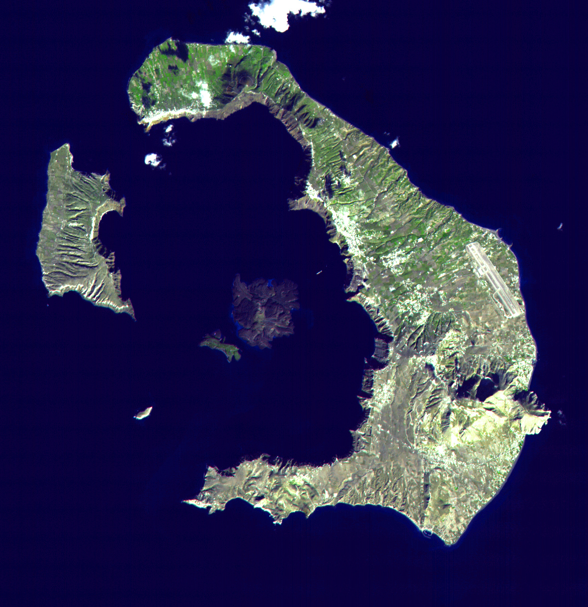
Minoan eruption
The Minoan eruption was a catastrophic volcanic eruption that devastated the Aegean island of Thera (also called Santorini) circa 1600 BC. It destroyed the Minoan settlement at Akrotiri, as well as communities and agricultural areas on nearby islands and the coast of Crete with subsequent earthquakes and tsunamis. With a Volcanic Explosivity Index (VEI) of 7,[citation needed] it resulted in the ejection of approximately 28–41 km3 (6.7–9.8 cu mi) of dense-rock equivalent (DRE), the eruption was one of the largest volcanic events in human history. Because tephra from the Minoan eruption serves as a marker horizon in nearly all archaeological sites in the Eastern Mediterranean, its precise date is of high importance and has been fiercely debated among archaeologists and volcanologists for decades, without coming to a definite conclusion.
Although there are no clear ancient records of the eruption, its plume and volcanic lightning may have been described in the Egyptian Tempest Stele. The Chinese Bamboo Annals reported unusual yellow skies and summer frost at the beginning of the Shang dynasty, which may have been a consequence of volcanic winter (similar to 1816, the Year Without a Summer, after the 1815 eruption of Mount Tambora).
Geological evidence shows the Thera volcano erupted numerous times over several hundred thousand years before the Minoan eruption. In a repeating process, the volcano would violently erupt, then eventually collapse into a roughly circular seawater-filled caldera, with numerous small islands forming the circle. The caldera would slowly refill with magma, building a new volcano, which erupted and then collapsed in an ongoing cyclical process.
Immediately before the Minoan eruption, the walls of the caldera formed a nearly continuous ring of islands, with the only entrance between Thera and the tiny island of Aspronisi. This cataclysmic eruption was centered on a small island just north of the existing island of Nea Kameni in the centre of the then-existing caldera. The northern part of the caldera was refilled by the volcanic ash and lava, then collapsed again.
The magnitude of the eruption, particularly the submarine pyroclastic flows, has been difficult to estimate because the majority of the erupted products were deposited in the sea. Together, these challenges result in considerable uncertainty regarding the volume of the Minoan eruption, with estimates ranging between 13–86 km3 (3.1–20.6 cu mi) DRE.
According to the latest analysis of marine sediments and seismic data gathered during ocean research expeditions from 2015 to 2019, the estimated volume of the material expelled during the volcanic eruption ranges from 28–41 km3 (6.7–9.8 cu mi) DRE.
The study revealed that the initial Plinian eruption was the most voluminous phase, ejecting 14–21 km3 (3.4–5.0 cu mi) magma and accounting for half of total erupted materials. This was followed by 3–4 km3 (0.72–0.96 cu mi) DRE co-ignimbrite fall, 5–9 km3 (1.2–2.2 cu mi) DRE pyroclastic flows and 5–7 km3 (1.2–1.7 cu mi) DRE intra-caldera deposits.
This eruption is comparable with the 1815 eruption of Mount Tambora, the 1257 Samalas eruption, Lake Taupo's Hatepe eruption around AD 230, and the 946 eruption of Paektu Mountain, which are among the largest eruptions in the last two thousand years.
Hub AI
Minoan eruption AI simulator
(@Minoan eruption_simulator)
Minoan eruption
The Minoan eruption was a catastrophic volcanic eruption that devastated the Aegean island of Thera (also called Santorini) circa 1600 BC. It destroyed the Minoan settlement at Akrotiri, as well as communities and agricultural areas on nearby islands and the coast of Crete with subsequent earthquakes and tsunamis. With a Volcanic Explosivity Index (VEI) of 7,[citation needed] it resulted in the ejection of approximately 28–41 km3 (6.7–9.8 cu mi) of dense-rock equivalent (DRE), the eruption was one of the largest volcanic events in human history. Because tephra from the Minoan eruption serves as a marker horizon in nearly all archaeological sites in the Eastern Mediterranean, its precise date is of high importance and has been fiercely debated among archaeologists and volcanologists for decades, without coming to a definite conclusion.
Although there are no clear ancient records of the eruption, its plume and volcanic lightning may have been described in the Egyptian Tempest Stele. The Chinese Bamboo Annals reported unusual yellow skies and summer frost at the beginning of the Shang dynasty, which may have been a consequence of volcanic winter (similar to 1816, the Year Without a Summer, after the 1815 eruption of Mount Tambora).
Geological evidence shows the Thera volcano erupted numerous times over several hundred thousand years before the Minoan eruption. In a repeating process, the volcano would violently erupt, then eventually collapse into a roughly circular seawater-filled caldera, with numerous small islands forming the circle. The caldera would slowly refill with magma, building a new volcano, which erupted and then collapsed in an ongoing cyclical process.
Immediately before the Minoan eruption, the walls of the caldera formed a nearly continuous ring of islands, with the only entrance between Thera and the tiny island of Aspronisi. This cataclysmic eruption was centered on a small island just north of the existing island of Nea Kameni in the centre of the then-existing caldera. The northern part of the caldera was refilled by the volcanic ash and lava, then collapsed again.
The magnitude of the eruption, particularly the submarine pyroclastic flows, has been difficult to estimate because the majority of the erupted products were deposited in the sea. Together, these challenges result in considerable uncertainty regarding the volume of the Minoan eruption, with estimates ranging between 13–86 km3 (3.1–20.6 cu mi) DRE.
According to the latest analysis of marine sediments and seismic data gathered during ocean research expeditions from 2015 to 2019, the estimated volume of the material expelled during the volcanic eruption ranges from 28–41 km3 (6.7–9.8 cu mi) DRE.
The study revealed that the initial Plinian eruption was the most voluminous phase, ejecting 14–21 km3 (3.4–5.0 cu mi) magma and accounting for half of total erupted materials. This was followed by 3–4 km3 (0.72–0.96 cu mi) DRE co-ignimbrite fall, 5–9 km3 (1.2–2.2 cu mi) DRE pyroclastic flows and 5–7 km3 (1.2–1.7 cu mi) DRE intra-caldera deposits.
This eruption is comparable with the 1815 eruption of Mount Tambora, the 1257 Samalas eruption, Lake Taupo's Hatepe eruption around AD 230, and the 946 eruption of Paektu Mountain, which are among the largest eruptions in the last two thousand years.