
Community hub
Recent from talks
Contribute something
Nothing was collected or created yet.
Santorini
View on Wikipedia

Key Information


Santorini (Greek: Σαντορίνη, romanized: Santoríni, pronounced [sa(n)doˈrini]), officially Thira (Greek: Θήρα, romanized: Thíra, pronounced [ˈθira]) or Thera,[a] is a Greek island in the southern Aegean Sea, about 200 km (120 mi) southeast from the mainland. It is the largest island of a small, circular archipelago formed by the Santorini caldera. It is the southernmost member of the Cyclades group of islands, with an area of approximately 73 km2 (28 sq mi) and a 2021 census population of 15,480. The municipality of Santorini includes the inhabited islands of Santorini and Therasia, and the uninhabited islands of Nea Kameni, Palaia Kameni, Aspronisi, Anydros, and Christiana. The total land area is 91 km2 (35 sq mi).[3] Santorini is part of the Thira regional unit.[4]
It is the most active volcanic centre in the South Aegean Volcanic Arc. The volcanic arc is approximately 500 km (300 mi) long and 20 to 40 km (12 to 25 mi) wide. The region first became volcanically active around 3–4 million years ago,[citation needed] though volcanism on Thera began around 2 million years ago with the extrusion of dacitic lavas from vents around Akrotiri. One of the largest volcanic eruptions in recorded history struck the island about 3,600 years ago, leaving a large water-filled caldera surrounded by deep volcanic ash deposits.
Names
[edit]The name "Santorini" is a contraction of Saint Irene, after an old church in the village of Perissa.[5][6] Of Venetian influence, the island bore the name Santorini since at least the middle of the twelfth century, the first mention being made by the geographer Al Idrissi c. 1154;[7]
During antiquity it was known as "Thēra" and before then, according to ancient writers, as "Kallístē" (Καλλίστη, "the most beautiful one"), and — according to a modern tradition — as "Strongýlē" (Στρογγύλη, "the circular one")[8][full citation needed]. The ancient name Thera, for Theras, the leader of the Spartans who colonized and gave his name to the island,[9] was revived in the nineteenth century as the official name of the island and its main city, but the colloquial Santorini is still in popular use.
History
[edit]Minoan Akrotiri
[edit]

The island was the site of one of the largest volcanic eruptions in recorded history: the Minoan eruption, sometimes called the Thera eruption, which occurred about 3,600 years ago at the height of the Minoan civilization.[6] The eruption left a large caldera surrounded by volcanic ash deposits hundreds of metres deep. It has been suggested that the colossal Santorini volcanic eruption is the source of the legend of the lost civilisation of Atlantis.[10] The eruption lasted for weeks and caused massive tsunami waves.[11]
The region first became volcanically active around 3–4 million years ago,[citation needed] though volcanism on Thera began around 2 million years ago with the extrusion of dacitic lavas from vents around Akrotiri.
Excavations starting in 1967 at the Akrotiri site under Spyridon Marinatos have made Thera (not known by this name at the time) the best-known Minoan site outside Crete, homeland of the culture. Only the southern tip of a large town has been uncovered, yet it has revealed complexes of multi-level buildings, streets, and squares with remains of walls standing as high as eight metres, all entombed in the solidified ash of the famous eruption of Thera. The site was not a palace-complex as found in Crete nor was it a conglomeration of merchant warehousing. Its excellent masonry and fine wall-paintings reveal a complex community. A loom-workshop suggests organized textile weaving for export. This Bronze Age civilization thrived between 3000 and 2000 BC, reaching its peak in the period between 2000 and 1630 BC.[12]
Many of the houses in Akrotiri are major structures, some of them three storeys high. Its streets, squares, and walls, sometimes as tall as eight metres, indicated that this was a major town; much is preserved in the layers of ejecta. The houses contain huge ceramic storage jars (pithoi), mills, and pottery, and many stone staircases are still intact. Noted archaeological remains found in Akrotiri are wall paintings or frescoes that have kept their original colour well, as they were preserved under many metres of volcanic ash. Judging from the fine artwork, its people were sophisticated and relatively wealthy. Among more complete frescoes found in one house are two antelopes painted with a confident calligraphic line, a man holding fish strung by their gills, a flotilla of pleasure boats that are accompanied by leaping dolphins, and a scene of women sitting in the shade of light canopies. Fragmentary wall-paintings found at one site are Minoan frescoes that depict "saffron-gatherers" offering crocus-stamens to a seated woman, perhaps a goddess important to the Akrotiri culture. The themes of the Akrotiri frescoes show no relationship to the typical content of the Classical Greek décor of 510 BC to 323 BC that depicts the Greek pantheon deities.
The town also had a highly developed drainage system. Pipes with running water and water closets found at Akrotiri are the oldest such utilities discovered.[13] The pipes run in twin systems, indicating that Therans used both hot and cold water supplies. The origin of the hot water they circulated in the town probably was geothermal, given the volcano's proximity.
The well preserved ruins of the ancient town are often compared to the spectacular ruins at Pompeii in Italy. The canopy covering the ruins collapsed in September 2005, killing one tourist and injuring seven; the site was closed until April 2012 while a new canopy was built.
The oldest signs of human settlement are Late Neolithic (4th millennium BC or earlier), but c. 2000–1650 BC Akrotiri developed into one of the Aegean's major Bronze Age ports, with recovered objects that came not just from Crete, but also from Anatolia, Cyprus, Syria, and Egypt, as well as from the Dodecanese and the Greek mainland.
Dating of the Bronze Age eruption
[edit]

The Minoan eruption provides a fixed point for the chronology of the second millennium BC in the Aegean, because evidence of the eruption occurs throughout the region and the site itself contains material culture from outside. The eruption occurred during the "Late Minoan IA" period of Minoan chronology at Crete and the "Late Cycladic I" period in the surrounding islands.
Archaeological evidence, based on an established chronology of Bronze Age Mediterranean cultures, dated the eruption to around 1500 BC.[14] These dates, however, conflict with radiocarbon dating which indicated that the eruption occurred between 1645–1600 BC,[15][16] and tree ring data which yielded a date of 1628 BC.[17] For those, and other reasons, the previous culturally based chronology has generally been questioned.[18]
In The Parting of the Sea: How Volcanoes, Earthquakes, and Plagues Shaped the Exodus Story, geologist Barbara J. Sivertsen theorizes a causal link between this eruption and the plagues of the Exodus.[19]
Ancient period
[edit]Santorini remained unoccupied throughout the rest of the Bronze Age, during which time the Greeks took over Crete. At Knossos, in a LMIIIA context (14th century BC), seven Linear B texts while calling upon "all the deities" make sure to grant primacy to an elsewhere-unattested entity called qe-ra-si-ja and, once, qe-ra-si-jo. If the endings -ia[s] and -ios represent an ethnic suffix, then this means "The One From Qeras[os]". If the initial consonant were aspirated, then *Qhera- would have become "Thera-" in later Greek. "Therasia" and its ethnikon "Therasios" are both attested in later Greek; and, since -sos was itself a genitive suffix in the Aegean Sprachbund, *Qeras[os] could also shrink to *Qera. If qe-ra-si-ja was an ethnikon first, then in following the entity the Cretans also feared whence it came.[20]
Probably after what is called the Bronze Age collapse, Phoenicians founded a site on Thera. Herodotus reports that they called the island Callista and lived on it for eight generations.[21] In the ninth century BC, Dorians founded the main Hellenic city on Mesa Vouno, 396 m (1,299 ft) above sea level. This group later claimed that they had named the city and the island after their leader, Theras. Today, that city is referred to as Ancient Thera.
In his Argonautica, written in Hellenistic Egypt in the third century BC, Apollonius Rhodius includes an origin and sovereignty myth of Thera being given by Triton in Libya to the Greek Argonaut Euphemus, son of Poseidon, in the form of a clod of dirt. After carrying the dirt next to his heart for several days, Euphemus dreamt that he nursed the dirt with milk from his breast, and that the dirt turned into a beautiful woman with whom he had sex. The woman then told him that she was a daughter of Triton named Calliste, and that when he threw the dirt into the sea it would grow into an island for his descendants to live on. The poem goes on to claim that the island was named Thera after Euphemus' descendant Theras, son of Autesion, the leader of a group of refugee settlers from Lemnos.
The Dorians have left a number of inscriptions incised in stone, in the vicinity of the temple of Apollo, attesting to pederastic relations between the authors and their lovers (eromenoi). These inscriptions, found by Friedrich Hiller von Gaertringen, have been thought by some archaeologists to be of a ritual, celebratory nature, because of their large size, careful construction and – in some cases – execution by craftsmen other than the authors. According to Herodotus,[22] following a drought of seven years, Thera sent out colonists who founded a number of cities in northern Africa, including Cyrene. In the fifth century BC, Dorian Thera did not join the Delian League with Athens; and during the Peloponnesian War, Thera sided with Dorian Sparta, against Athens. The Athenians took the island during the war, but lost it again after the Battle of Aegospotami. During the Hellenistic period, the island was a major naval base for Ptolemaic Egypt.
Medieval and Ottoman period
[edit]

.jpg)


As with other Greek territories, Thera then was ruled by the Romans. When the Roman Empire was divided, the island passed to the eastern side of the Empire which today is known as the Byzantine Empire.[23] According to George Cedrenus, the volcano erupted again in the summer of 727, the tenth year of the reign of Leo III the Isaurian.[24] He writes: "In the same year, in the summer, a vapour like an oven's fire boiled up for days out of the middle of the islands of Thera and Therasia from the depths of the sea, and the whole place burned like fire, little by little thickening and turning to stone, and the air seemed to be a fiery torch." This terrifying explosion was interpreted as a divine omen against the worship of religious icons[25][26] and gave the emperor Leo III the Isaurian the justification he needed to begin implementing his Iconoclasm policy.
The name "Santorini" first appears c. 1153–1154 in the work of the Muslim geographer al-Idrisi, as "Santurin", from the island's patron saint, Saint Irene of Thessalonica.[27] After the Fourth Crusade, it was occupied by the Duchy of Naxos which held it up to circa 1280 when it was reconquered by Licario (the claims of earlier historians that the island had been held by Jacopo I Barozzi and his son as a fief have been refuted in the second half of the twentieth century);[28][29][30] it was again reconquered from the Byzantines circa 1301 by Iacopo II Barozzi, a member of the Cretan branch of the Venetian Barozzi family, whose descendant held it until it was annexed to Venice in c. 1335 by Niccolo Sanudo after various legal and military conflicts.[31] In 1318–1331 and 1345–1360 it was raided by the Turkish principalities of Menteshe and Aydın, but did not suffer much damage.[27] Because of the Venetians the island became home to a sizable Catholic community and is still the seat of a Catholic bishopric.

From the 15th century on, the suzerainty of the Republic of Venice over the island was recognized in a series of treaties by the Ottoman Empire, but this did not stop Ottoman raids, until it was captured by the Ottoman admiral Piyale Pasha in 1576, as part of a process of annexation of most remaining Latin possessions in the Aegean.[27] It became part of the semi-autonomous domain of the sultan's Jewish favourite, Joseph Nasi. Santorini retained its privileged position in the 17th century, but suffered in turn from Venetian raids during the frequent Ottoman–Venetian wars of the period, even though there were no Muslims on the island.[27]
Santorini was captured briefly by the Russians under Alexey Orlov during the Russo-Turkish War of 1768–1774, but returned to Ottoman control after.

19th century
[edit]
In 1807, the islanders were forced by the Sublime Porte to send 50 sailors to Mykonos to serve in the Ottoman navy.[33]
In 1810, Santorini with 32 ships possessed the seventh largest of the Greek fleet after Kefallinia (118), Hydra (120), Psara (60), Ithaca (38) Spetsai (60) and Skopelos (35).[34]
During the last years of Ottoman rule, the majority of residents were farmers and seafarers who exported their abundant produce, while the level of education was improving on the island, with the Monastery of Profitis Ilias being one of the most important monastic centres in the Cyclades.[33]
In 1821, the island was home to 13,235 inhabitants, which within a year had risen to 15,428.[35]
Greek War of Independence
[edit]As part of its plans to foment a revolt against the Ottoman Empire and gain Greek Independence, Alexandros Ypsilantis, the head of the Filiki Eteria in early 1821, dispatched Dimitrios Themelis from Patmos and Evangelis Matzarakis ( –1824), a sea captain from Kefalonia who had Santorini connections to establish a network of supporters in the Cyclades.[36] As his authority,[clarification needed] Matzarakis had a letter from Ypsilantis (dated 29 December 1820) addressed to the notables of Santorini and the Orthodox metropolitan bishop Zacharias Kyriakos (served 1814–1842). At the time, the population of Santorini was divided between those who supported independence, and (particularly among the Catholics and non-Orthodox) those who were ambivalent or distrustful of a revolt being directed by Hydra and Spetses or were fearful of the sultan's revenge. While the island didn't come out in direct support of the revolt, they did send 100 barrels of wine to the Greek fleet as well in April 1821,[clarify] 71 sailors, a priest and the presbyter Nikolaos Dekazas, to serve on the Spetsiote fleet.[33]
Because of the lack of majority support for direct participation in the revolt, it was necessary for Matzarakis to enlist the aid of Kefalonians living in Santorini to, on 5 May 1821[33] (the feast day of the patron saint of the island), raise the flag of the revolution and then expel the Ottoman officials from the island.[36] The Provisional Administration of Greece organized the Aegean islands into six provinces, one of which was Santorini and appointed Matzarakis its governor in April 1822.[37][38] While he was able to raise a large amount of money (double that collected on Naxos), he was soon found to lack the diplomatic skills needed to convince the islanders who had enjoyed considerable autonomy to now accept direction from a central authority and contribute tax revenue to it. He claimed to his superiors that the islanders needed "political re-education" as they did not understand why they had to pay higher taxes than those levied under the Ottomans in order to support the struggle for independence. The hostility against the taxes caused many of the tax collectors to resign.
Things were also not helped by the governor's authoritarian character, arbitrariness and arrests of prominent islanders losing him the support of Zacharias Kyriakos, who had initially supported Matzarakis. In retaliation Matzarakis accused him of being a "Turkophile" and had the archbishop imprisoned and then exiled him. The abbots of the monasteries, the priests and the prelates, complained to Demetrios Ypsilantis, president of the National Assembly.
Matzarakis soon had to hire bodyguards as the island descended into open revolt against him.[36] Fearful for his life Matzarakis later fled the island,[36] and was dismissed from his governorship by Demetrios Ypsilantis. Mazarakis however later represented Santorini in the National Assembly and following his death was succeeded in that position in November 1824 by Pantoleon Augerino.
Once they heard of massacres of the Greek population of Chios in April 1822, many islanders became fearful of Ottoman reprisals, with two villages stating they were prepared to surrender,[36] though sixteen monks from the Monastery of Profitis Ilias, led by their abbot Gerasimos Mavrommatis declared in writing their support for the revolt.[39] Four commissioners for the Aegean islands (among them, Benjamin of Lesvos and Konstantinos Metaxas) appointed by the Provisional Administration of Greece arrived in July 1822 to investigate the issues on Santorini. The commissioners were uncompromising in their support for Matzarakis. With news from Chios fresh in their minds the island's notables eventually arrested Metaxas, with the intention of handing him over to the Ottomans in order to prove their loyalty. He was rescued by his Ionian guards.
Matters became so heated that Antonios Barbarigos ( –1824) who had been serving in the First National Assembly at Epidaurus since 20 January 1820 was seriously wounded in the head by a knife attack on Santorini in October 1822 during a dispute between the factions. In early 1823, the Second National Assembly at Astros, imposed a contribution of 90,000 grosis on Santorini to fund the fight for independence, while in 1836 they also had to contribute in 1826 to the obligatory loan of 190,000 grosis imposed on the Cyclades.[35]

In decree 573 issued by the National Assembly 17 May 1823, Santorini was recognized as one of 15 provinces in the Greek controlled Aegean (nine in the Cyclades and six in the Sporades).[37]
The island became part of the fledgling Greek state under the London Protocol of 3 February 1830, rebelled against the government of Ioannis Kapodistrias in 1831, and became definitively part of the independent Kingdom of Greece in 1832, with the Treaty of Constantinople.[27]
Santorini joined an insurrection that had broken out in Nafplio on 1 February 1862 against the rule of King Otto of Greece. However, the royal authorities was able to quickly restore control and the revolt had been suppressed by 20 March of that year. However, the unrest arose again later in the year which lead to the 23 October 1862 Revolution and the overthrow of King Otto.
World War II
[edit].jpg)
During the Second World War, Santorini was occupied in 1941 by Italian forces and then by the Germans following the Italian armistice in 1943. In 1944, the German garrison on Santorini was raided by a group of British Special Boat Service Commandos, killing most of its men. Five locals were later shot in reprisal, including the mayor.[40][41]
Post-war
[edit]In general, the island's economy continued to decline following World War II, with a number of factories closing as a lot of industrial activity relocated to Athens. In an attempt to improve the local economy, the Union of Santorini Cooperatives was established 1947 to process, export and promote the islands agriculture products, in particular its wine. In 1952, they constructed near the village of Monolithos what is today the island's only remaining tomato processing factory. The island's tourism in the early 1950s generally took the form of small numbers of wealthy tourists on yacht cruises though the Aegean. The island's children would present arriving passengers with flowers and bid them happy sailing by lighting small lanterns along the steps from Fira down to the port, offering them a beautiful farewell spectacle. Once such visitor was the actress Olivia de Havilland, who visited the island in September 1955 at the invitation of Petros Nomikos.[42]
In the early 1950s, the shipping magnate Evangelos P. Nomikos and his wife Loula decided to support their birthplace and so asked residents to choose whether they wanted the couple to pay for the construction of either a hotel or a hospital, to which local authorities replied that they would prefer a hotel.
In 1954, Santorini had approximately 12,000 inhabitants and very few visitors. The only modes of transport on the island were a jeep, a small bus and the island's traditional donkeys and mules.
1956 earthquake
[edit]At 05:11 local time (CEST, 03:11 UTC) on 9 July 1956, the 1956 Amorgos earthquake (magnitude – depending on the particular study – of 7.5,[43] 7.6,[43] 7.7[44] or 7.8[45]) struck 30 km (19 mi) south of the island of Amorgos, about 50 km (31 mi) from Santorini. It was the largest earthquake of the 20th century in Greece and also had a devastating impact on Santorini.[45][44] It was followed by aftershocks, the most significant being the first occurring at 05:24, 13 minutes after the main shock, which had a 7.2 magnitude.[45] This aftershock which originated close to the island of Anafi is believed to have been responsible for most of the damage and casualties on Santorini.[45] The earthquake was accompanied by a tsunami which, while much higher at other islands, is estimated to have reached 3 metres at Perissa and 2 metres at Vlichada on Santorini.[45]
Immediately following the earthquake, the Greek Prime Minister Konstantinos Karamanlis declared Santorini a state of "large-scale local disaster" and visited the island to inspect the situation on 14 July.[46]
Many countries had offered to send relief efforts, though Greece refused to accept the offer of the United Kingdom to send warships to help from Cyprus where they were involved in the Cyprus Emergency.[46]
As there was no airport, the Greek military made air drops of food, tents and supplies and camps for homeless people were established on the outskirts of Fira.[47]
On Santorini, the earthquakes killed 53 people and injured another 100.[48][46] 35% of the island's houses collapsed and 45% suffered major or minor damage.[46] In total, 529 houses were destroyed, 1,482 were severely damaged and 1,750 lightly damaged.[46] Almost all public buildings were completely destroyed. One of the largest buildings that survived unscathed was the newly built Hotel Atlantis, which allowed it to be used as a temporary hospital and to house public services. The greatest damage was experienced on the Western side along the edge of the caldera, especially at Oia, with parts of the ground collapsing into the sea. The damage from the earthquake reduced most of the population to extreme poverty and caused many to leave the island in search of better opportunities, with most settling in Athens.[46]
2025 earthquakes
[edit]
Santorini experienced a major earthquake swarm in February 2025.[49][50] Hundreds of tremors occurred in the Aegean Sea, to the north-east of the island, some measuring up to magnitude 5. The earthquake sequence began on about 27th January, and intensified after 1 February 2025. As the earthquakes continued, there was a precautionary evacuation of Santorini by sea and by air.[51]
During the weekend of 1 and 2 February, more than 200 undersea tremors were detected. The epicenters were primarily in a growing cluster between the islands of Santorini, Anafi, Amorgos, Ios and the uninhabited islet of Anydros. Many of the earthquakes registered magnitudes above 4.5 on the Moment magnitude scale. The strongest earthquake of the swarm occurred on 10 February, and measured Mw 5.3.[52] At the time of the crisis, experts explained that they considered the earthquakes to be tectonic rather than volcanic in nature, but the pattern and frequency of seismic activity prompted significant concern among scientists and authorities.[53] Seismologist Manolis Skordylis indicated on public radio that a seismic fault line had been activated with potential to cause an earthquake exceeding magnitude 6.0.[54]
Greek authorities implemented several emergency measures, which included the deployment of emergency crews and a 26-member rescue team with a rescue dog to the region.[53] Schools were closed on Santorini, Anafi, Amorgos, and Ios.[55] Access to areas near cliffs was restricted due to increased risk of landslides. In Fira, several gathering points for evacuation were established.[53] Access to shorelines and certain ports, including Santorini's old port, was restricted due to tsunami risk, with residents instructed to move inland.[54]
Greece's Minister of Climate Crisis and Civil Protection Vasilis Kikilias emphasized the precautionary nature of the response. Prime Minister of Greece Kyriakos Mitsotakis, who spoke while in Brussels, called for calm while acknowledging the intensity of the earthquake swarm. Hotels were told to drain their swimming pools to minimize potential earthquake damage to structures.[53] Aegean Airlines doubled its flight frequency between Athens and Santorini for a two-day period to carry out evacuations. Ferry companies increased their service frequency in response to surging demand, resulting in long queues forming at evacuation ports.[54] Around 6,000 residents left the island by ferry beginning on 2 February, while up to 2,700 left by air from 3 to 4 February. The South Aegean Regional Fire Department was placed on general alert.[56] A state of emergency was declared in Santorini by the Greek government on 6 February.[57]
In Turkey, the Disaster and Emergency Management Presidency (AFAD) and the Mineral Research and Exploration General Directorate (MTA) warned that the earthquakes could lead to volcanic activity around the Kolumbo submarine volcano off Santorini.[58]
The earthquakes began to decline in intensity and number after mid-February, and the seismic crisis ended in late February. The state of emergency was lifted on 3rd March. Later analysis of the observations of earthquakes and ground deformation by scientists pointed to the potential involvement of a deep intrusion of magma in causing the events.[59][60]
Tourism
[edit]
The expansion of tourism in recent years has resulted in the growth of the economy and population.[61] Santorini was ranked the world's top island by many magazines and travel sites, including the Travel+Leisure Magazine,[62] the BBC,[63] as well as the US News.[64] An estimated 2 million tourists visit annually.[65] Santorini has been emphasising sustainable development and the promotion of special forms of tourism, the organization of major events such as conferences and sport activities.
The island's pumice quarries have been closed since 1986, in order to preserve the caldera. In 2007, the cruise ship MS Sea Diamond ran aground and sank inside the caldera. As of 2019, Santorini is popular with Asian couples who come to the island to have pre-wedding photos taken against the backdrop of the landscape.[66]

Geography
[edit]
Geological setting
[edit]The Cyclades are part of a metamorphic complex that is known as the Cycladic Massif. The complex formed during the Miocene and was folded and metamorphosed during the Alpine orogeny around 60 million years ago. Thera is built upon a small non-volcanic basement that represents the former non-volcanic island, which was approximately 9 by 6 km (5.6 by 3.7 mi). The basement rock is primarily composed of metamorphosed limestone and schist, which date from the Alpine Orogeny. These non-volcanic rocks are exposed at Mikros Profititis Ilias, Mesa Vouno, the Gavrillos ridge, Pyrgos, Monolithos, and the inner side of the caldera wall between Cape Plaka and Athinios.
The metamorphic grade is a blueschist facies, which results from tectonic deformation by the subduction of the African Plate beneath the Eurasian Plate. Subduction occurred between the Oligocene and the Miocene, and the metamorphic grade represents the southernmost extent of the Cycladic blueschist belt.
Volcanism
[edit]Volcanism on Santorini is due to the Hellenic subduction zone southwest of Crete. The oceanic crust of the northern margin of the African Plate is being subducted under Greece and the Aegean Sea, which is thinned continental crust. The subduction compels the formation of the Hellenic arc, which includes Santorini and other volcanic centres, such as Methana, Milos, and Kos.[67]


The island is the result of repeated sequences of shield volcano construction followed by caldera collapse.[68] The inner coast around the caldera is a sheer precipice of more than 300 m (980 ft) drop at its highest, and exhibits the various layers of solidified lava on top of each other, and the main towns perched on the crest. The ground then slopes outwards and downwards towards the outer perimeter, and the outer beaches are smooth and shallow. Beach sand colour depends on which geological layer is exposed; there are beaches with sand or pebbles made of solidified lava of various colours: such as the Red Beach, the Black Beach and the White Beach. The water at the darker coloured beaches is significantly warmer because the lava acts as a heat absorber.
The area of Santorini incorporates a group of islands created by volcanoes, spanning across Thera, Thirasia, Aspronisi, Palea, and Nea Kameni.

Santorini has erupted many times, with varying degrees of explosivity. There have been at least twelve large explosive eruptions, of which at least four were caldera-forming.[67] The most famous eruption is the Minoan eruption, detailed below. Eruptive products range from basalt all the way to rhyolite, and the rhyolitic products are associated with the most explosive eruptions.
The earliest eruptions, many of which were submarine, were on the Akrotiri Peninsula, and active between 650,000 and 550,000 years ago.[67] These are geochemically distinct from the later volcanism, as they contain amphiboles.
Over the past 360,000 years there have been two major cycles, each culminating with two caldera-forming eruptions. The cycles end when the magma evolves to a rhyolitic composition, causing the most explosive eruptions. In between the caldera-forming eruptions are a series of sub-cycles. Lava flows and small explosive eruptions build up cones, which are thought to impede the flow of magma to the surface.[67] This allows the formation of large magma chambers, in which the magma can evolve to more silicic compositions. Once this happens, a large explosive eruption destroys the cone. The Kameni islands in the centre of the lagoon are the most recent example of a cone built by this volcano, with much of them hidden beneath the water.

Minoan eruption
[edit]During the Bronze Age, Santorini was the site of the Minoan eruption, one of the largest volcanic eruptions in human history. It was centred on a small island just north of the existing island of Nea Kameni in the centre of the caldera; the caldera itself was formed several hundred thousand years ago by the collapse of the centre of a circular island, caused by the emptying of the magma chamber during an eruption. It has been filled several times by ignimbrite since then, and the process repeated itself, most recently 21,000 years ago. The northern part of the caldera was refilled by the volcano, then collapsed once more during the Minoan eruption. Before the Minoan eruption, the caldera formed a nearly continuous ring with the only entrance between the islet of Aspronisi and Thera; the eruption destroyed the sections of the ring between Aspronisi and Therasia, and between Therasia and Thera, creating two new channels.
On Santorini, a deposit of white tephra thrown from the eruption is up to 60 m (200 ft) thick, overlying the soil marking the ground level before the eruption, and forming a layer divided into three fairly distinct bands indicating different phases of the eruption. Archaeological discoveries in 2006 by a team of international scientists revealed that the Santorini event was much more massive than previously thought; it expelled 61 km3 (15 cu mi) of magma and rock into the Earth's atmosphere, compared to previous estimates of only 39 km3 (9.4 cu mi) in 1991,[53][54] producing an estimated 100 km3 (24 cu mi) of tephra. Only the Mount Tambora volcanic eruption of 1815, the 181 AD eruption of the Taupo Volcano, and possibly Baekdu Mountain's 946 AD eruption have released more material into the atmosphere during the past 5,000 years.

The Minoan eruption has been considered as possible inspiration for ancient stories including Atlantis and the Exodus. The content of the stories is not supported by current archaeological research, but remain popular in pseudohistory and pseudoarchaeology.[citation needed]
Post-Minoan volcanism
[edit]Post-Minoan eruptive activity is concentrated on the Kameni islands, in the centre of the lagoon. They have been formed since the Minoan eruption, and the first of them broke the surface of the sea in 197 BC.[67] Nine subaerial eruptions are recorded in the historical record since that time, with the most recent ending in 1950.
In 1707, an undersea volcano breached the sea surface, forming the current centre of activity at Nea Kameni in the centre of the lagoon, and eruptions centred on it continue – the twentieth century saw three such, the last in 1950. Santorini was also struck by a devastating earthquake in 1956. Although the volcano is dormant at the present time, at the current active crater (there are several former craters on Nea Kameni), steam and carbon dioxide are emitted.
Small tremors and reports of strange gaseous odours over the course of 2011 and 2012 prompted satellite radar technological analyses and these revealed the source of the symptoms; the magma chamber under the volcano was swollen by a rush of molten rock by 10 to 20 million cubic metres between January 2011 and April 2012, which also caused parts of the island's surface to rise out of the water by a reported 8 to 14 centimetres.[69] Scientists say that the injection of molten rock was equivalent to 20 years' worth of regular activity.[69]
At the beginning of February 2025, there were hundreds of minor earthquakes up to magnitude 5 near Santorini, mostly in an area around the tiny islet of Anydros, north-east of Santorini. About 9,000 people left the island out of a population of 15,500 in the face of seismic activity that could last weeks. The tremors were attributed to tectonic plate movements rather than volcanic activity.[70]
Climate
[edit]According to the National Observatory of Athens Santorini has a hot semi-arid climate (Köppen climate classification: BSh) with Mediterranean (Csa) characteristics, such as the dry summers and the relatively wetter winters. It has an average annual precipitation of around 270 mm (11 in) and an average annual temperature of around 19 °C (66 °F).[71][72]
| Climate data for Santorini 183 m a.s.l. | |||||||||||||
|---|---|---|---|---|---|---|---|---|---|---|---|---|---|
| Month | Jan | Feb | Mar | Apr | May | Jun | Jul | Aug | Sep | Oct | Nov | Dec | Year |
| Record high °C (°F) | 25.4 (77.7) |
23.7 (74.7) |
23.8 (74.8) |
29.6 (85.3) |
35.3 (95.5) |
38.7 (101.7) |
39.4 (102.9) |
38.6 (101.5) |
33.9 (93.0) |
33.1 (91.6) |
30.3 (86.5) |
22.7 (72.9) |
39.4 (102.9) |
| Mean daily maximum °C (°F) | 14.3 (57.7) |
14.7 (58.5) |
16.1 (61.0) |
19.6 (67.3) |
23.3 (73.9) |
27.9 (82.2) |
30.1 (86.2) |
30.2 (86.4) |
27.2 (81.0) |
22.8 (73.0) |
19.4 (66.9) |
15.6 (60.1) |
21.8 (71.2) |
| Daily mean °C (°F) | 12.2 (54.0) |
12.5 (54.5) |
13.7 (56.7) |
16.9 (62.4) |
20.1 (68.2) |
24.4 (75.9) |
26.7 (80.1) |
26.8 (80.2) |
24.3 (75.7) |
20.2 (68.4) |
17.0 (62.6) |
13.6 (56.5) |
19.0 (66.3) |
| Mean daily minimum °C (°F) | 10.1 (50.2) |
10.3 (50.5) |
11.3 (52.3) |
13.6 (56.5) |
16.9 (62.4) |
21.0 (69.8) |
23.3 (73.9) |
23.5 (74.3) |
21.3 (70.3) |
17.5 (63.5) |
14.7 (58.5) |
11.5 (52.7) |
16.3 (61.2) |
| Record low °C (°F) | 1.0 (33.8) |
−0.4 (31.3) |
2.1 (35.8) |
6.8 (44.2) |
12.8 (55.0) |
16.2 (61.2) |
19.6 (67.3) |
19.2 (66.6) |
15.1 (59.2) |
11.3 (52.3) |
9.1 (48.4) |
2.0 (35.6) |
−0.4 (31.3) |
| Average rainfall mm (inches) | 52.7 (2.07) |
40.7 (1.60) |
44.9 (1.77) |
12.1 (0.48) |
8.2 (0.32) |
3.6 (0.14) |
0.03 (0.00) |
2.5 (0.10) |
3.0 (0.12) |
15.1 (0.59) |
33.7 (1.33) |
54.6 (2.15) |
271.13 (10.67) |
| Source: National Observatory of Athens Monthly Bulletins (Jul 2013-Mar 2025)[73][74] | |||||||||||||
Economy
[edit]Santorini's primary industry is tourism, particularly in the summer months. Agriculture also forms part of its economy, and the island sustains a wine industry.[61] The economic life of Santorini before 1960, when the flow of foreign visitors to the island for tourist purposes gradually began, was based on crops and trade.
Agriculture
[edit].jpg)
In the middle of the 19th century, Santorini had great commercial activity with foreign countries and especially with Russia, where it exported all of its wine production.[75][76] Because of its unique ecology and climate – and especially its volcanic ash soil – Santorini is home to unique and prized produce such as the Santorini cherry tomato. Viticulture, whose history goes back to prehistoric times, could not remain unaffected by the rapid increase in tourism, where there was a gradual decrease.[61] Viticulture is the most important sector of agricultural production in Santorini.
Wine industry
[edit]The island remains the home of a small wine industry, based on the indigenous Assyrtiko grape variety, with auxiliary cultivations of Aegean white varieties such as Athiri and Aidani and the red varieties such as Mavrotragano and Mandilaria. The vines are extremely old and resistant to phylloxera (attributed by local winemakers to the well-drained volcanic soil and its chemistry), so the vines needed no replacement during the great phylloxera epidemic of the late 19th century. In their adaptation to their habitat, such vines are planted far apart, as their principal source of moisture is dew, and they often are trained in the shape of low-spiralling baskets, with the grapes hanging inside to protect them from the winds.[77]
The viticultural pride of the island is the sweet and strong Vinsanto (Italian: "holy wine"), a dessert wine made from the best sun-dried Assyrtiko, Athiri, and Aidani grapes, and undergoing long barrel aging (up to twenty or twenty-five years for the top cuvées). It matures to a sweet, dark, amber-orange unctuous dessert wine that has achieved worldwide fame, possessing the standard Assyrtiko aromas of citrus and minerals, layered with overtones of nuts, raisins, figs, honey, and tea.


White wines from the island are extremely dry with a strong citrus scent and mineral and iodide salt aromas contributed by the ashy volcanic soil, whereas barrel aging gives to some of the white wines a slight frankincense aroma, much like Vinsanto. It is not easy to be a winegrower in Santorini; the hot and dry conditions give the soil a very low productivity. The yield per hectare is only 10 to 20% of the yields that are common in France or California. The island's wines are standardised and protected by the "Vinsanto" and "Santorini" OPAP designations of origin.[78]
Brewing
[edit]A brewery, the Santorini Brewing Company, began operating out of Santorini in 2011, based in the island's wine region.[79]
Governance
[edit]The present municipality of Thera (officially: "Thira", Greek: Δήμος Θήρας),[80][81] which covers all settlements on the islands of Santorini and Therasia, was formed at the 2011 local government reform, by the merger of the former Oia and Thera municipalities.[4]
Oia is now called a Κοινότητα (community), within the municipality of Thera, and it consists of the local subdivisions (Greek: τοπικό διαμέρισμα) of Therasia and Oia.
The municipality of Thera includes an additional 12 local subdivisions on Santorini island: Akrotiri, Emporio, Episkopis Gonia, Exo Gonia, Imerovigli, Karterados, Megalohori, Mesaria, Pyrgos Kallistis, Thera (the seat of the municipality), Vothon, and Vourvoulos.[82]

Towns and villages
[edit]Attractions
[edit]Architecture
[edit]The traditional architecture of Santorini is similar to that of the other Cyclades, with low-lying cubical houses, made of local stone and whitewashed or limewashed with various volcanic ashes used as colours. These colours, in recent years, tend to replace white in the colour of house façades, according to the traditional architecture of the island as it was developed until the great earthquake of 1956. The unique characteristic is the common use of the hypóskapha: extensions of houses dug sideways or downwards into the surrounding pumice. These rooms are prized because of the high insulation provided by the air-filled pumice, and are used as living quarters of unique coolness in the summer and warmth in the winter. These are premium storage space for produce, especially for wine cellaring: the Kánava wineries of Santorini.
When strong earthquakes struck the island in 1956, half the buildings were completely destroyed and a large number suffered repairable damage. The underground dwellings along the ridge overlooking the caldera, where the instability of the soil was responsible for the great extent of the damage, needed to be evacuated. Most of the population of Santorini had to emigrate to Piraeus and Athens.[83]

,_Greece-2.jpg)
Fortifications
[edit]During the 15th and 16th centuries, the Cyclades were under threat from pirates who plundered the harvests, enslaved men and women and sold them in the slave markets. The small bays of the island were also ideal as hideouts. In response the islanders built their settlements at the highest, most inaccessible points, and very close to, or on top of, each other; while their external walls, devoid of openings, formed a protective perimeter around the village. In addition the following additional types of fortifications were built throughout the island to protect the island's inhabitants.
- Casteli (castles), also written as kasteli, were large fortified permanent settlements. There were five on the island, Agios Nikolaos (at Oia), Akrotiri, Emborio, Pyrgos, and Skaros. At the entrance to every casteli was a church dedicated to Agia (St.) Theodosia, the Protector-Saint of castles.
- Goulas (from the Turkish word kule which means 'tower'[84]) were multi-storey, rectangular, and the highest tower of most kastelli. There were four goulas on the island. They were used both as an observatory and as a place of refuge for the islanders. They had thick walls, parapets, an iron gate, murder holes, and embrasures.
- Viglio were small coastal watchtowers, which were permanently garrisoned, from where a watch was maintained and an alarm raised when a pirate ship was sighted.
Infrastructure
[edit]Electricity
[edit]Electricity for both Santorini and Therasia is principally supplied from the Thira Autonomous Power Station which is located at Monolithos in the eastern part of Santorini. Owned by Public Power Corporation (PPC) it has generators powered by diesel engines and gas turbines. The two islands have a total installed capacity of 75.09 MW of thermal generation and 0.25 MW of renewable generation.[85] There is a programme underway at a cost of €124 million as part of the Cyclades Interconnection Project to connect the island via a submarine cable to Naxos and hence by extension to the mainland system by 2023.[86]
A fire at the power station in Monolithos on 13 August 2018 put it out of service, resulting in a total loss of electricity supply across the two islands. Within four days electricity had been restored to all but 10% of the islands' consumers. Vessels were dispatched to carry two power generators to assist in supporting the restoration of the electricity supply.[87][88]
Electricity is distributed around the island by The Hellenic Electricity Distribution System Operator (HEDNO S.A. or DEDDIE S.A.) which is a 100% owned subsidiary of PPC. A cable connects the Thirasia and Santorini electrical distribution systems.
Transportation
[edit]The central bus station is in Fira, the capital of the island, where buses depart very frequently. They cover routes to almost all places around the island and to most tourist spots.
Apart from its connection with other Cyclades islands, Santorini is also connected by ferry with Piraeus on a daily basis all year long, with up to 5 direct crossings during summer.
Airport
[edit]
Santorini is one of the few Cyclades Islands with a major airport, which lies about 6 km (4 mi) southeast of downtown Thera. The main asphalt runway (16L-34R) is 2,125 m (6,972 ft) in length, and the parallel taxiway was built to runway specification (16R-34L). It can accommodate Boeing 757, Boeing 737, Airbus A320 series, Avro RJ, Fokker 70, and ATR 72 aircraft. Scheduled airlines include the new Olympic Air, Aegean Airlines, Ryanair, and Sky Express, with flights chartered from other airlines during the summer, and with transport to and from the air terminal available through buses, taxis, hotel car-pickups, and hire cars.
Land
[edit]Bus services link Fira to most parts of the island.[89]
Ports
[edit]
Santorini has two ports: Athinios (Ferry Port) and Skala (Old Port).[90][91] Cruise ships anchor off Skala and passengers are transferred by local boatmen to shore at Skala where Fira is accessed by cable car, on foot or by donkeys and mules. The use of donkeys for tourist transportation has attracted significant criticism from animal rights organisations for animal abuse and neglect, including failure to provide the donkeys with sufficient water or rest.[92] Tour boats depart from Skala for Nea Kameni and other Santorini destinations.[90][91]
Water and sewerage
[edit]As the island lies in a rain shadow between the mountains of Crete and the Peloponnese water seems to have been scarce at least from post-eruption times.[93] This, combined with the small size of the island, the lack of rivers, and the nature of the soil, which is largely composed of volcanic ash, as well as the high summer temperatures meant that there was very little surface water.[94] With only one spring (Zoodochos Pigi – the Life-giving Spring) this encouraged the practice of diverting any rain that fell on roofs and courtyards to elaborate underground cisterns, supplemented in the 20th century with water imported from other areas of Greece. Owing to the lack of water islanders developed non-irrigated crops such as vines and olives that could survive on only the scant moisture provided by the common early-morning fog condensing on the ground as dew.
Many cisterns ceased to be used following the 1956 earthquake. As tourism increased, the existing rainwater harvesting methods proved incapable of supplying the increased demand. As a result, it has become necessary to construct desalination plants which now provide running but non-potable water to most residents. This has led to many of the historic cisterns falling into disrepair.[95]
The first desalination plant was built at Oia following a donation in 1992 by the Oia-born businessman Aristeidis Alafouzos. By 2003 the plant had expanded to house three desalination units (of which two had been donated by Alafouzos).[96] As of 2020 the plant has six desalination units with a total capacity of 2,800 m3 (99,000 cu ft) per day.[97]
In addition to Oia there are currently desalination plants at Aghia Paraskevi, located on the southwest side of the airport with a capacity of 5,000 m3 (180,000 cu ft) per day which supplies Kamari, Vothonas, Messaria, Exo Gonia, Mesa Gonia, Agia Paraskevi, and Monolithos;[98] Fira with a capacity of 1,200 m3 (42,000 cu ft) per day;[97] Akrotiri (also known as the Cape) which has two units with a total capacity of 650 m3 (23,000 cu ft) per day;[97] Exo Gialos which has two units with a total capacity of 2,000 m3 (71,000 cu ft) per day which supplies Fira, Imerovigli, Karteradou, Pyrgos, Megalochori and Vourvoulou; and Therasia which has two TEMAK units with a total capacity of 350 m3 (12,000 cu ft) per day.[97]
There are also a number of small autonomous drinking water production units with a capacity of 6 m3 (210 cu ft) per day located at Kamari, Emporio, Messaria and Thirasia Island.[97]
The provision of water supply and sewage treatment and disposal on both Santorini and Therasia Islands is undertaken by the municipally owned DEYA Thiras. It was founded in May 2011, after the merging of the Municipal Water Supply and Sewerage Company of Thera (DEYA Thera) and the Community Water Supply and Sewerage Company of Oia (K .Ε.Υ.Α. Οίας). Known as DEYATH it is responsible for the planning, construction, management, operation and maintenance of the water supply system (desalination plants and pumping wells), irrigation, drainage, and the wastewater collection networks and treatment plants for the islands of Thira (Santorini) and Therasia. The Loulas and Evangelos Nomikos Foundation has funded a number of projects aimed at improving the water supply and sewage systems on the islands.
Notable people
[edit]- Aristeidis Alafouzos, businessman
- Giannis Alafouzos, former president of Panathinaikos F.C.
- Mariza Koch, singer
- Spyros Markezinis, politician
- Themison of Thera
In popular culture
[edit]The movie Summer Lovers (1982) was filmed on location here.[99]
The island was a featured filming location in the 2005 film The Sisterhood of the Traveling Pants and its sequel.[100]
Santorini inspired French pop singer-songwriter Nolwenn Leroy for her song "Mystère", released on her 2005 album Histoires Naturelles ("Aux criques de Santorin").[101]
Australian Singer-songwriter Donny Benét wrote a single called Santorini, released as part of his 2018 album The Don.
The Santorini Film Festival is held annually at the open-air cinema, Cinema Kamari, in Santorini.[102][103]
American hip hop musician Rick Ross has a song titled "Santorini Greece", and its 2017 music video was shot on the island.[104]
Santorini appears in 2014's Call of Duty Advanced Warfare during the mission Manhunt. The player tracks down a target before chasing that target through the streets.[105]
The 2018 video game Assassin's Creed Odyssey features a DLC extra entitled Fate of Atlantis, in which a gateway to the mythical lost city of Atlantis is located in a temple beneath the island of Thera.[106]
The board game Santorini, inspired by the architecture of the island's cliffside villages, was published in 2004 by Gordon Hamilton.[107]
The K-Pop girl group ARTMS had an official photoshoot in Santorini for their 2024 Season's greetings.
In the film The Parting of the Sea: How Volcanoes, Earthquakes, and Plagues Shaped the Exodus Story, geologist Barbara J. Sivertsen seeks to establish a link between the eruption of Santorini (c. 1600 BC) and the Exodus of the Israelites from Egypt in the Bible.
See also
[edit]Notes
[edit]- ^ English: /ˈθɪərə/ THEER-ə; Classical Greek: Θήρα, romanized: Thḗrā.
References
[edit]- ^ Municipality of Thira, Municipal elections – October 2023, Ministry of Interior
- ^ "Αποτελέσματα Απογραφής Πληθυσμού - Κατοικιών 2021, Μόνιμος Πληθυσμός κατά οικισμό" [Results of the 2021 Population - Housing Census, Permanent population by settlement] (in Greek). Hellenic Statistical Authority. 29 March 2024.
- ^ "Population & housing census 2001 (incl. area and average elevation)" (PDF) (in Greek). National Statistical Service of Greece. Archived from the original (PDF) on 21 September 2015.
- ^ a b "ΦΕΚ A 87/2010, Kallikratis reform law text". Government Gazette (in Greek). Archived from the original on 23 October 2021. Retrieved 7 September 2021.
- ^ "Early Christian Basilica of Agia Irini in Parissa". Santorini – santorini-more.com. 1 February 2022. Retrieved 3 December 2023.
- ^ a b Scheffel, Richard L.; Wernet, Susan J., eds. (1980). Natural Wonders of the World. United States of America: Reader's Digest Association, Inc. pp. 336–337. ISBN 978-0-89577-087-5.
- ^ A. Savvides, s.v. Santurin Adasi̊ in Encyclopaedia of Islam, Second Edition, volume IX, 1997, p. 20.
- ^ C. Doumas (editor). Thera and the Aegean world: papers presented at the second international scientific congress, Santorini, Greece, August 1978. London, 1978. ISBN 0-9506133-0-4
- ^ Harry Thurston Peck, Harpers Dictionary of Classical Antiquities (1898), Theras
- ^ Pausanias (29 August 2023). "Atlantis and Santorini: Connecting Myths and Geology". Akrotiri Museum.
- ^ "Victims of Thera Eruption 3,600 Years Ago Finally Found, 200km Away in Turkey". Haaretz. 28 December 2021.
- ^ TheModernAntiquarian.com Archived 29 October 2012 at the Wayback Machine, C. Michael Hogan, Akrotiri, The Modern Antiquarian (2007).
- ^ "History – Minoan Akrotiri". Santorini Official Guides. Archived from the original on 29 January 2024. Retrieved 29 January 2024.
- ^ Warren, Peter M. (2006). "The Date of the Thera Eruption in Relation to Aegean-Egyptian Interconnections and the Egyptian Historical Chronology". In Czerny E.; Hein I.; Hunger H.; Melman D.; Schwab A. (eds.). Timelines: Studies in Honour of Manfred Bietak. Orientalia Lovaniensia Analecta, 149. Louvain-la-Neuve, Belgium: Peeters. pp. 2: 305–21. ISBN 978-90-429-1730-9.
- ^ Manning, Sturt W.; Ramsey, Christopher Bronk; Kutschera, Walter; Higham, Thomas; Kromer, Bernd; Steier, Peter; Wild, Eva M. (2006). "Chronology for the Aegean Late Bronze Age 1700–1400 B.C.". Science. 312 (5773): 565–569. Bibcode:2006Sci...312..565M. doi:10.1126/science.1125682. PMID 16645092. S2CID 21557268. Archived from the original on 12 February 2020. Retrieved 10 March 2007.
- ^ Aydar, Erkan; ÇİNer, Atilla; Ersoy, Orkun; ÉCochard, Emilie; Fouache, Eric G. (2021). "Volcanic ash and tsunami record of the Minoan Late Bronze Age Eruption (Santorini) in a distal setting, southwestern Turkey". Journal of Quaternary Science. 36 (4): 586–597. Bibcode:2021JQS....36..586A. doi:10.1002/jqs.3314.
- ^ Baillie, Michael G. L.; Mackenzie, A. R. Munro (1988). "Irish tree rings, Santorini and volcanic dust veils". Nature. 332 (6162): 344–346. Bibcode:1988Natur.332..344B. doi:10.1038/332344a0.
- ^ Manning, Sturt W. (2022). "Second Intermediate Period date for the Thera (Santorini) eruption and historical implications". PLOS ONE. 17 (9) e0274835. Public Library of Science. Bibcode:2022PLoSO..1774835M. doi:10.1371/journal.pone.0274835. PMC 9488803. PMID 36126026.
- ^ Sivertsen, Barbara J. (2009). The Parting of the Sea: How Volcanoes, Earthquakes, and Plagues Shaped the Story of the Exodus. Princeton University Press. ISBN 978-0-691-13770-4.
- ^ "Minoan Qe-Ra-Si-Ja. The Religious Impact of the Thera Volcano on Minoan Crete". Archived from the original on 14 June 2006.
- ^ Hist. IV. 147.
- ^ Hist. IV.149–165
- ^ "Thera – The Ancient City". HeritageDaily – Archaeology News. 29 June 2020. Archived from the original on 3 July 2020. Retrieved 3 July 2020.
- ^ George Cedrenus, Σύνοψις ἱστορίων, Vol I, p. 795.
- ^ Theophanes the Confessor, Chronography pp. 621-622 : «ος [ο Λέων] την κατ' αυτού θείαν οργήν υπέρ εαυτού λογισάμενος». Νικηφόρος σελ. 64 : «Ταύτά φασιν ακούσαντα τον βασιλέα υπολαμβάνειν θείας οργής είναι μηνύματα».
- ^ Ioannis Panagiotopoulos, «Το ηφαίστειο της Θήρας και η Eικονομαχία». Θεολογία 80 (2009), pp. 235–253.
- ^ a b c d e Savvides, A. (1997). "Santurin Adasi̊". In Bosworth, C. E.; van Donzel, E.; Heinrichs, W. P. & Lecomte, G. (eds.). The Encyclopaedia of Islam, Second Edition. Volume IX: San–Sze. Leiden: E. J. Brill. p. 20. ISBN 978-90-04-10422-8.
- ^ Silvano Borsari, "Studi sulle colonie veneziane in Romania nel XIII secolo", 1966, pp. 35–37 and 79.
- ^ Louise Buenger Robbert (1985). "Venice and the Crusades". In Setton, Kenneth M.; Zacour, Norman P.; Hazard, Harry W. (eds.). A History of the Crusades, Volume V: The Impact of the Crusades on the Near East. Madison and London: University of Wisconsin Press. pp. 379–451. ISBN 0-299-09140-6. p. 432
- ^ Marina Koumanoudi, "The Latins in the Aegean after 1204: Interdependence and Interwoven Interests," in Urbs capta: The Fourth Crusade and its Consequences, 2005, p.262
- ^ Marina Koumanoudi, "The Latins in the Aegean after 1204: Interdependence and Interwoven Interests," in Urbs capta: The Fourth Crusade and its Consequences, 2005, p.263
- ^ Grasset de Saint-Sauveur, Jacques (1796). "Moeurs, usages et costumes de l'isle de thera ou santorin". Encyclopédie des voyages (in French). Vol. Europe volume 1. f240. BnF 45651328p.
- ^ a b c d Ελευθερία (17 October 2019). "Σημεία αντιφώνησης του Προέδρου της Δημοκρατίας κ.Προκοπίου Παυλοπούλου κατά την ανακήρυξή του σ' Επίτιμο Δημότη του Δήμου Θήρας" [Reply to the President of the Republic Mr. Prokopiou Pavlopoulos during his proclamation as Honorary Citizen of the Municipality of Thira]. Aρχική - Προεδρία της Δημοκρατίας (in Greek). Presidency of the Hellenic Republic. Retrieved 19 March 2022.
- ^ Economou, Emmanouil M.L.; Kyriazis, Nicholas C.; Prassa, Annita (2016). "The Greek Merchant Fleet as a National Navy During the War of Independence 1800–1830" (PDF). MPRA. Archived (PDF) from the original on 11 May 2022. Retrieved 29 April 2022.
- ^ a b "Σαντορίνη και Επανάσταση του 1821" [Santorini and the Revolution of 1821]. Rssing. 21 March 2014. Archived from the original on 24 April 2023. Retrieved 20 March 2022.
- ^ a b c d e Mazower, Mark (2021). The Greek Revolution: 1821 and the Making of Modern Europe (Hardback). Allen Lane. pp. 144, 148, 157–160. ISBN 978-0-241-00410-4.
- ^ a b "Σφραγιδες Ελευθεριας 1821–1832: Σφραγίδες Κοινοτήτων – Μοναστηρίων Προσωρινής Διοικήσεως τής Ελλάδος' Ελληνικής Πολιτείας" [Seals of Freedom 1821–1832: Seals of Communities – Monasteries of Provisional Administration of Greece, Greek State] (PDF). Historical and Ethnologica' Society of Greece. 1983. pp. 43, 44. Archived (PDF) from the original on 29 October 2022. Retrieved 20 March 2022.
- ^ "Μαντζαράκης Ευαγγέλης: (Μαντζοράκης, Μαντσαράκης Γλυκούδης, Ματζαράκης Ευάγγελος)" [Mantzarakis Evangelis: (Mantzorakis, Mantsarakis Glykoudis, Matzarakis Evangelos)]. Foundation of the Greek Parliament for Parliamentarism and Democracy. Archived from the original on 29 January 2022. Retrieved 20 March 2022.
- ^ "Η Ιερά Μονή Προφήτου Ηλιού Θήρας" [The Holy Monastery of Profitos Ilios Thira]. Ιερά Μονή Προφήτου Ηλιού Θήρας. 31 October 2021. Archived from the original on 7 March 2022. Retrieved 22 March 2022.
- ^ Mortimer, Gavin. The Special Boat Squadron in WW2, Osprey, 2013, ISBN 1782001891.
- ^ Lewis, Damien (2014). Churchill's Secret Warriors. Quercus. ISBN 978-1-84866-917-8.
- ^ Amburn, Ellis (2018). Olivia de Havilland and the Golden Age of Hollywood (Hardback). Lanham, MD: Rowman & Littlefield. p. 241. ISBN 978-1-4930-3409-3.
- ^ a b Tsampouraki-Kraounaki, Konstantina; Sakellariou, Dimitris; Rousakis, Grigoris; Morfis, Ioannis; Panagiotopoulos, Ioannis; Livanos, Isidoros; Manta, Kyriaki; Paraschos, Fratzeska; Papatheodorou, George (2021). "The Santorini-Amorgos Shear Zone: Evidence for Dextral Transtension in the South Aegean Back-Arc Region, Greece". Geosciences. 11 (5). Basel, Switzerland: MDPI: 216. Bibcode:2021Geosc..11..216T. doi:10.3390/geosciences11050216. Archived (PDF) from the original on 24 April 2023. Retrieved 24 April 2022.
- ^ a b Papadimitriou, Eleftheria; Sourlas, Georgios; Karakostas, Vassilios (2005). "Seismicity Variations in the Southern Aegean, Greece, Before and After the Large (M7.7) 1956 Amorgos Earthquake Due to Evolving Stress". Pure and Applied Geophysics. 162 (5): 783–804. Bibcode:2005PApGe.162..783P. doi:10.1007/s00024-004-2641-z. S2CID 140605036.
- ^ a b c d e Okal, Emile A.; Synolakis, Costas E.; Uslu, Burak; Kalligeris, Nikos; Voukouvalas, Evangelos (2009). "The 1956 earthquake and tsunami in Amorgos, Greece". Geophysical Journal International. 178 (3): 1533–1554. Bibcode:2009GeoJI.178.1533O. doi:10.1111/j.1365-246X.2009.04237.x.
- ^ a b c d e f Simos, Andriana (9 July 2020). "On This Day: The 1956 Santorini earthquake and its devastating aftermath". The Greek Herald. Archived from the original on 24 April 2022. Retrieved 24 April 2022.
- ^ "20 Still Missing In Aegean Quake", New York Times, p. 5, 11 July 1956, archived from the original on 24 April 2022, retrieved 20 March 2022
- ^ Sedgwick, A.C. (10 July 1956), "Quake, Tidal Wave Hit Aegean; At Least 42 Dead in Greek Isles", New York Times, pp. 1, 6, archived from the original on 24 April 2022, retrieved 20 March 2022
- ^ "The swarm of earthquakes shaking Santorini prompts Greece to declare an emergency". AP News. 6 February 2025. Retrieved 8 February 2025.
- ^ Andrews, Robin George (8 February 2025). "Santorini is at the center of a mystery: Why do earthquakes keep shaking the island?". National Geographic. Retrieved 8 February 2025.
- ^ "Thousands evacuate Santorini after earthquakes shake Greek island". bbc.com. 4 February 2025. Retrieved 4 February 2025.
- ^ ANSS. "M 5.3–12 km ENE of Mesariá, Greece 2025". Comprehensive Catalog. U.S. Geological Survey.
- ^ a b c d e "Santorini eruption much larger than originally believed". University of Rhode Island Department of Communications and Marketing. Archived from the original on 13 July 2015.
- ^ a b c d Lovett, Richard A. (23 August 2006). "Atlantis Eruption Twice as Big as Previously Believed, Study Suggests". National Geographic News. Archived from the original on 2 March 2009.
- ^ Liakos, Chris; Stockwell, Billy (2 February 2025). "Schools shut as tremors shake Greece's 'Instagram island'". CNN. Retrieved 3 February 2025.
- ^ Aikman, Ian; Stallard, Esme (4 February 2025). "Thousands evacuate Santorini amid earthquake fears". BBC. Retrieved 4 February 2025.
- ^ "Earthquake surge prompts state of emergency on Greek island of Santorini". AP News. 6 February 2025. Retrieved 6 February 2025.
- ^ "Turkish agency warns that earthquakes in Aegean Sea may trigger volcanic activity". Hurriyet Daily News. 6 February 2025. Retrieved 6 February 2025.
- ^ Howell, Evan (24 September 2025). "Thousands of quakes struck a major Greek volcano, mapping the plumbing beneath it". Science News. Retrieved 24 September 2025.
- ^ Andrews, Robin George (24 September 2025). "This year thousands of mysterious earthquakes hit Santorini. Scientists finally know why". National Geographic. Retrieved 24 September 2025.
- ^ a b c Chrepa, Eleni (21 July 2024). "Tourism has hijacked Santorini's wine production as agricultural land becomes exorbitant while visitor numbers continue to climb". Fortune Europe. Retrieved 22 July 2024.
- ^ "2011 World's Best Awards". Travel+Leisure. Archived from the original on 12 July 2011. Retrieved 16 July 2011.
- ^ "World's Best Islands". BBC. Archived from the original on 1 December 2011. Retrieved 1 December 2011.
- ^ "World's Best Island". US News. Archived from the original on 8 April 2014. Retrieved 1 April 2014.
- ^ Smith, Helena (28 August 2017). "Santorini's popularity soars but locals say it has hit saturation point". The Guardian. Archived from the original on 28 August 2017. Retrieved 28 August 2017.
- ^ Horowitz, Jason; Boushnak, Laura (6 August 2019). "The Bride, the Groom and the Greek Sunset: A Perfect Wedding Picture". The New York Times. Archived from the original on 8 December 2019. Retrieved 8 December 2019.
- ^ a b c d e Druitt, Timothy H.; L. Edwards; R.M. Mellors; D.M. Pyle; R.S.J. Sparks; M. Lanphere; M. Davies; B. Barriero (1999). Santorini Volcano. Geological Society Memoir. Vol. 19. London: Geological Society. ISBN 978-1-86239-048-5.
- ^ "Geology of Santorini". Volcano Discovery. Archived from the original on 30 May 2017. Retrieved 7 April 2012.
- ^ a b Brian Handwerk (12 September 2012). "Santorini Bulges as Magma Balloons Underneath". National Geographic Society. Archived from the original on 20 September 2012. Retrieved 19 September 2012.
- ^ Aikman, Ian; Papanikolaou, Nikos; Stallard, Esme (4 February 2025). "Thousands evacuate Santorini after earthquakes shake Greek island". BBC News.
- ^ "Monthly Bulletins". meteo.gr. Archived from the original on 2 February 2023. Retrieved 17 April 2023.
- ^ "Latest Conditions in Santorini". Archived from the original on 17 April 2023. Retrieved 17 April 2023.
- ^ "Monthly Bulletins". meteo.gr.
- ^ "Weather station of Santorini". Retrieved 7 May 2023.
- ^ Gilis, Odysseas. "Οδυσσέας Γκιλής. ΘΗΡΑ ΣΑΝΤΟΡΙΝΗ ΣΤΡΟΓΓΥΛΗ ΚΑΛΛΙΣΤΗ" (in Greek). Archived from the original on 12 April 2023. Retrieved 11 April 2023.
- ^ "Santorini information". Retrieved 11 April 2023.
- ^ An early observer of this was Theodore Bent in January 1884: "[At] Santorin they always weave the tendrils of their vines into circles, the effect in winter being that each vineyard looks as if hampers were placed all over it in rows and at intervals of every two yards." (The Cyclades, or Life Among the Insular Greeks. London, 1885, p. 41).
- ^ "Greece Santorini History". www.greecesantorini.com. Archived from the original on 23 February 2016. Retrieved 3 November 2015.
- ^ "Greece's Handcrafted Beers Hit the Spot". greece.greekreporter.com. 16 January 2018. Archived from the original on 21 August 2018. Retrieved 22 August 2018.
- ^ "Municipallity of Thira, official municipal government website". thira.gov.gr (in Greek and English). Archived from the original on 13 January 2025. Retrieved 13 January 2025.
- ^ "Municipality of Thira, English language version of the official municipal government website". Archived from the original on 27 July 2012. Retrieved 17 April 2011.
- ^ "Spreadsheet table of all administrative subdivisions in Greece, and their population as of the 18 March 2001 census" (Excel). Hellenic Republic, Ministry of Interior, Decentralization and E-government. Archived from the original on 19 July 2011. Retrieved 17 April 2011.
- ^ "Restoration, Reconstruction and Simulacra" (PDF). Archived (PDF) from the original on 7 May 2022. Retrieved 9 March 2014.
- ^ Σπηλιοπούλου Ι.-Κωτσάκης Α., Οι Πύργοι και οι οχυρωμένες κατοικίες των νησιών του Αιγαίου και της Πελοποννήσου (14ος-19ος αι.), Eoa Kai Esperia, 8 (2013), pp. 254–255 [1]. Archived 9 November 2022 at the Wayback Machine.
- ^ GeoEnergy, Think (19 January 2018). "Greek island of Santorini partners with PPC Renewables on geothermal project | ThinkGeoEnergy – Geothermal Energy News". Archived from the original on 5 May 2022. Retrieved 5 May 2022.
- ^ "Santorini-Naxos grid link tender set to be announced by IPTO". Energy Press. 29 December 2020. Archived from the original on 20 January 2021. Retrieved 22 January 2021.
- ^ "Interior, tourism ministers to Santorini to check power problems". Kathimerini. 16 August 2013. Archived from the original on 24 April 2023. Retrieved 15 January 2021.
- ^ "Power supply returning to normal on Santorini". Kathimerini. 17 August 2013. Archived from the original on 24 April 2023. Retrieved 17 January 2021.
- ^ "Santorini Public Buses". www.ktel-santorini.gr. Archived from the original on 15 June 2019. Retrieved 22 September 2019.
- ^ a b "Athinios Ferry Port in Santorini". santorini-port.com. Archived from the original on 25 April 2025.
- ^ a b "Municipal Port Fund of Thira (Santorini Port Authority) - Ship Traffic (Live Map)". santoriniports.gov.gr (in Greek and English). Municipal Port Fund of Thira. Archived from the original on 25 April 2025.
- ^ "Greek island accused of abusing its star attraction: donkeys". DW.COM. 8 July 2019. Archived from the original on 8 July 2019. Retrieved 11 July 2019.
- ^ "Santorini Water Museum, Greece". Water Museums. 25 July 1995. Archived from the original on 20 January 2021. Retrieved 15 January 2021.
- ^ Bitis, Ioannis (2013). "Water supply methods in Ancient Thera: the case of the sanctuary of Apollo Karneios". Water Supply. 13 (3): 638–645. Bibcode:2013WatSu..13..638B. doi:10.2166/ws.2013.017.
- ^ Enriquez, Jared; Tipping, David C.; Lee, Jung-Ju; Vijay, Abhinav; Kenny, Laura; Chen, Susan; Mainas, Nikolaos; Holst-Warhaft, Gail; Steenhuis, Tammo (2017). "Water Management in the Tourism Economy: Linking the Mediterranean's Traditional Rainwater Cisterns to Modern Needs". Water. 9 (11). doi:10.3390/w9110868.
- ^ "Santorini: Bottled drinking water". Kathimerini. 30 July 2003. Archived from the original on 24 April 2023. Retrieved 20 January 2021.
- ^ a b c d e "Desalination Deva Thira". DEYA Thira. 2020. Archived from the original on 25 January 2021. Retrieved 18 January 2021.
- ^ Solaris, Giorgos (27 May 2020). "Tender for the supply and installation of new desalination plants in Exo Gialos Fira, Santorini" (in Greek). Retrieved 1 March 2025.
- ^ "Summer Lovers". Reelstreets. Archived from the original on 10 May 2021. Retrieved 10 May 2021.
- ^ "Sisterhood of the Traveling Pants 2 Filming Locations". TripSavvy. Archived from the original on 10 May 2021. Retrieved 10 May 2021.
- ^ "Nolwenn Leroy – Mystère". Lyrics.com.
- ^ "Santorini Film Festival". santorinifilmfest.com. Archived from the original on 25 April 2025.
- ^ "Santorini Film Festival". FilmFreeway. Archived from the original on 25 July 2020. Retrieved 27 October 2019.
- ^ "Here's What Greeks Think of Rick Ross' "Santorini Greece" Music Video". The Culture Trip. 20 September 2017. Archived from the original on 9 May 2021. Retrieved 10 May 2021.
- ^ Madrigal, Hector (7 November 2014). "Manhunt". IGN.com. IGN. Retrieved 13 July 2025.
- ^ "How to start The Fate of Atlantis Assassin's Creed Odyssey DLC". VG 24/7. Archived from the original on 10 May 2021. Retrieved 10 May 2021.
- ^ Miller, David (2 March 2017). "Spin Master Taking On Santorini and 5-Minute Dungeon for Push in to Hobby Market". Purple Pawn. Archived from the original on 1 October 2017. Retrieved 30 September 2017.
Sources
[edit]- Forsyth, Phyllis Y.: Thera in the Bronze Age, Peter Lang Pub. Inc., New York, 1997. ISBN 0-8204-4889-3.
- Friedrich, W., Fire in the Sea: the Santorini Volcano: Natural History and the Legend of Atlantis, translated by Alexander R. McBirney, Cambridge University Press, Cambridge, 2000.
- History Channel's "Lost Worlds: Atlantis" archeology series. Features scientists Dr. J. Alexander MacGillivray (archeologist), Dr. Colin F. MacDonald (archaeologist), Professor Floyd McCoy (vulcanologist), Professor Clairy Palyvou (architect), Nahid Humbetli (geologist) and Dr. Gerassimos Papadopoulos (seismologist).
Further reading
[edit]- Radiocarbon dating of Egyptian artifacts puts Thera (Santorini) volcanic eruption prior to Pharaoh Ahmose - phys dot org - October 22, 2025
- Bond, A. and Sparks, R. S. J. (1976). "The Minoan eruption of Santorini, Greece". Journal of the Geological Society of London, Vol. 132, pp. 1–16.
- Doumas, C. (1983). Thera: Pompeii of the ancient Aegean. London: Thames and Hudson.
- Pichler, H. and Friedrich, W. L. (1980). "Mechanism of the Minoan eruption of Santorini". Doumas, C. Papers and Proceedings of the Second International Scientific Congress on Thera and the Aegean World II.
- Was the Bronze Age Volcanic Eruption of Thira (Santorini) a Megacatastrophe? A Geological/Archeological Detective Story. A lecture presented at University of Illinois Urbana-Champaign (UIUC), by the Grant Heiken, independent consultant, author, geologist (retired), sponsored by Center for Global Studies (cgs.illinois.edu) and Center for Advanced Study (cas.uiuc.edu).
- The Sacred Rock in Santorini
- Thera (Santorin) - Catholic Encyclopedia article at New Advent
- The Eruption of Thera: Date and Implications at therafoundation.org
- Santorini eruption much larger than originally believed at University of Rhode Island
External links
[edit] Definitions from Wiktionary
 Media from Commons
 News from Wikinews
 Quotations from Wikiquote
 Texts from Wikisource
 Textbooks from Wikibooks
 Resources from Wikiversity
 Travel information from Wikivoyage
- Thira Municipality official website thira.gr
- Thira Municipality official website thira.gov.gr
- Thira (Santorini) santorini.gr


| Algeria |
|
|---|---|
| Cyprus | |
| Greece | |
| Israel | |
| Italy | |
| Lebanon | |
| Libya | |
| Malta |
|
| Morocco | |
| Portugal |
|
| Spain | |
| Syria | |
| Tunisia | |
| Other | |
Santorini
View on GrokipediaNomenclature
Etymology and Historical Names
The island's earliest recorded names include Strongýli (Στρογγύλη), meaning "the round one," which alluded to its original circular shape prior to the Minoan eruption around 1600 BCE, and Kallísti (Καλλίστη), translating to "the most beautiful," as referenced in ancient mythological accounts linking it to the Argonauts' voyages.[7][8] In classical antiquity, it was known as Thḗra (Θήρα), derived from Theras, a Spartan leader who, according to Herodotus, colonized the island around the 9th century BCE with settlers from Laconia and Libya.[9][10] This name persisted in Greek usage and remains the official administrative designation for the island and its regional unit, Dímos Thíras.[11] The modern name Santorini originated during the Venetian period in the 13th century, following the establishment of the Duchy of Naxos by Marco Sanudo after the Fourth Crusade's sack of Constantinople in 1204 CE. It is a contraction of Santa Īrēnē (Saint Irene), honoring a Byzantine-era chapel dedicated to the martyr Saint Irene, located either in Perissa or near Pyrgos as per varying historical accounts.[8][12] Venetian cartographers and sailors popularized the name, which supplanted Thera in Western European languages, though Greek Orthodox tradition continued favoring Thira.[13]Physical Geography
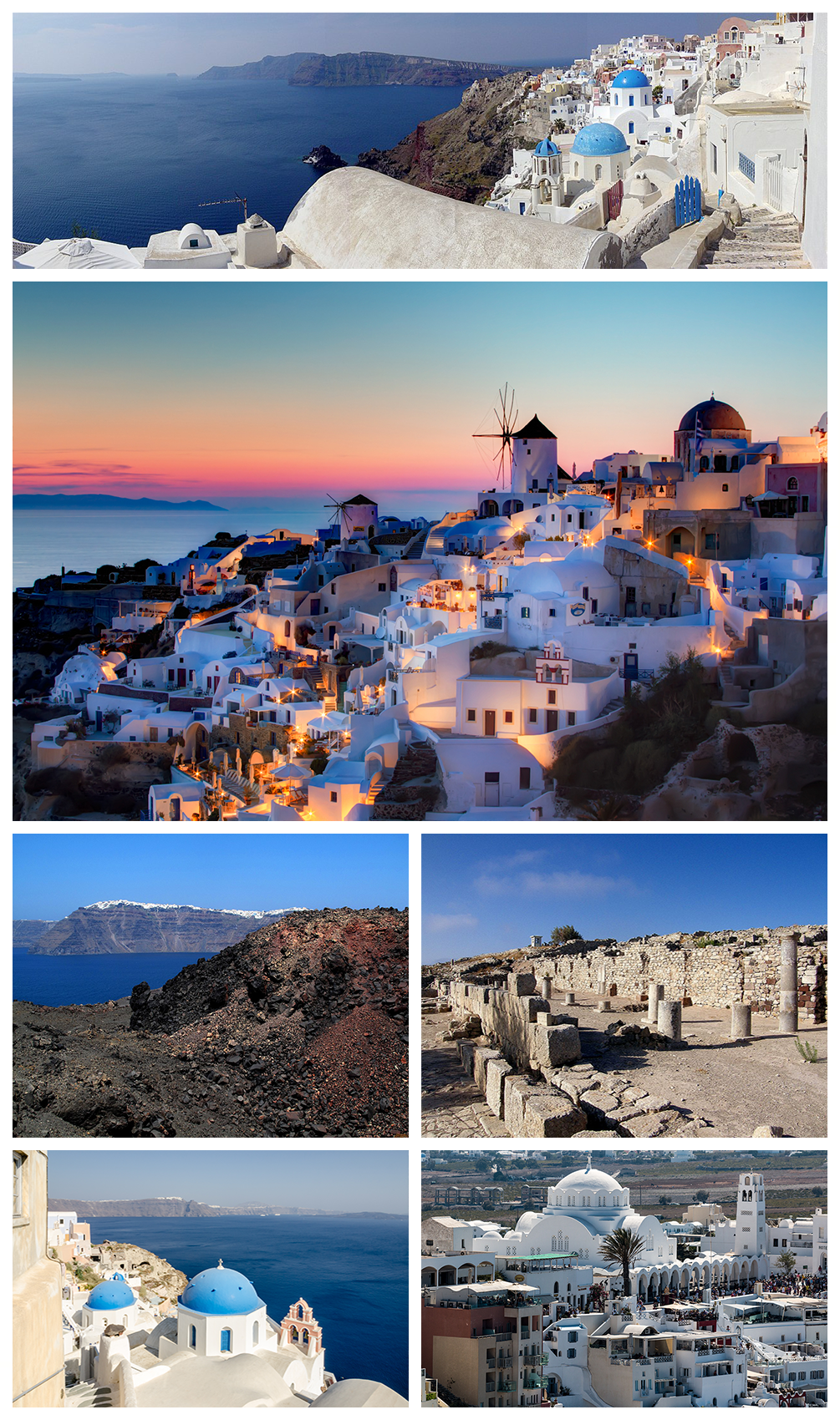
Location and Topography
Santorini, officially the island municipality of Thira, lies in the southern Aegean Sea as the southernmost member of the Cyclades island group in Greece. Positioned approximately 200 km southeast of the Greek mainland and 117 km north of Crete, its central coordinates are 36°23′N 25°27′E, with latitude ranging from 36°20′N to 36°29′N and longitude from 25°19′E to 25°29′E.[15][16] Administratively, it forms part of the South Aegean region, encompassing a total land area of about 91 km² across its principal islands.[17] The archipelago comprises five main islands formed by volcanic activity: the largest, Thira (also known as Santorini proper), spans roughly 73 km² and hosts the majority of settlements; Thirasia to the west; the smaller Aspronisi in the southern caldera channel; and the central volcanic islets of Palea Kameni and Nea Kameni.[16] These islands encircle a largely submerged caldera measuring approximately 12 km north-south by 7 km east-west, resulting from prehistoric collapses that shaped the crescent-like configuration of the main landmasses.[18] Topographically, Santorini features dramatic steep-walled cliffs along the caldera rim, rising 150 to 350 meters above sea level, with the eastern and southern coasts exhibiting rugged, near-vertical drops into the sea.[19] The caldera's floor plunges to depths of up to 390 meters below sea level, while inland terrain on Thira includes undulating volcanic plains, low hills, and the island's highest point, Mount Profitis Ilias, at 567 meters.[20] The overall east-west span reaches 18 km from Cape Exomitis to Cape Mavropetra, with narrow coastal strips contrasting the elevated, dissected plateaus formed by successive lava flows and pyroclastic deposits.[19]Climate
Santorini exhibits a hot-summer Mediterranean climate under the Köppen classification (Csa), featuring hot, dry summers and mild, wetter winters influenced by its Aegean Sea location.[21] Annual precipitation averages approximately 337 mm, concentrated primarily from October to March, while summers (June to September) receive negligible rainfall, often less than 5 mm per month.[22] The island's aridity supports unique agricultural adaptations, such as low-yield viticulture, but also contributes to periodic water scarcity.[6] Temperatures vary seasonally from winter lows around 9–12°C to summer highs of 27–29°C, with annual averages near 18.8°C.[23] Extremes rarely exceed 33°C or drop below 6°C, though strong northerly Etesian winds (known as Meltemi) prevail from May to September, enhancing summer aridity and cooling coastal areas with gusts up to 40 km/h or more.[24] Winters bring occasional storms, with January as the wettest month at about 120 mm of rain over 9–10 days.[25]| Month | Avg. High (°C) | Avg. Low (°C) | Precipitation (mm) |
|---|---|---|---|
| January | 14 | 10 | 120 |
| February | 14 | 10 | 90 |
| March | 16 | 11 | 60 |
| April | 19 | 13 | 30 |
| May | 23 | 17 | 10 |
| June | 27 | 21 | 5 |
| July | 28 | 23 | 0 |
| August | 28 | 23 | 0 |
| September | 26 | 21 | 10 |
| October | 23 | 18 | 50 |
| November | 19 | 14 | 70 |
| December | 16 | 11 | 100 |
Geology and Volcanism
Geological Formation
Santorini's geological formation is rooted in its position within the South Aegean Volcanic Arc, a product of oblique subduction where the African plate converges northward beneath the Aegean microplate at rates of 3-5 cm per year along the Hellenic Trench.[26][27] This tectonic regime, involving continental extension and back-arc spreading, has facilitated magma generation through flux melting of the mantle wedge, leading to calc-alkaline to shoshonitic volcanism dominated by andesitic to rhyolitic compositions.[28][29] Arc-wide volcanism initiated around 4.7 million years ago, but Santorini's activity commenced in the Quaternary, with the initial submarine shield-building phase constructing a basaltic foundation overlain by dacitic and rhyolitic domes.[18][28] The volcanic edifice evolved through episodic construction and destruction, encompassing at least three lava shields and multiple explosive cycles that deposited thick pyroclastic sequences.[20] Overlapping shield volcanoes formed the proto-island, with significant growth occurring between approximately 650,000 and 200,000 years ago, including the extrusion of viscous lavas that built steep-sided domes on the Akrotiri Peninsula.[30] This pre-caldera stratigraphy, exposed in the caldera's walls, reveals interlayered lavas, tuffs, and ignimbrites from plinian and phreatomagmatic eruptions, reflecting a magma chamber periodically replenished by slab-derived fluids and partial melts.[31] Culminating in structural collapse, the complex underwent at least four nested or overlapping caldera-forming events between 360,000 and 21,000 years ago, each triggered by rapid evacuation of 10-50 km³ of magma during plinian eruptions, resulting in a 12 km diameter, 300-400 m deep basin partially infilled by later deposits.[18] The modern crescent-shaped topography of Thera (the main island) represents the resurgent rim of these collapses, with peripheral islands like Thirasia preserving unsubmerged flanks, while central islets such as Nea and Palea Kameni emerged from post-caldera dome-building starting in the Hellenistic period.[32] This formation process underscores the island's status as a continental-margin volcano, where extensional tectonics amplify magma ascent and caldera instability.[26]Minoan Eruption and Associated Debates
The Minoan eruption, also known as the Thera eruption, was a Plinian-style volcanic event that occurred on the island of Thera (modern Santorini) during the late Bronze Age, ejecting an estimated 30–60 cubic kilometers of dense rock equivalent material and ranking as a Volcanic Explosivity Index (VEI) 7 eruption, among the most powerful in the Holocene geological epoch.[33] The eruption unfolded in multiple phases, beginning with phreatomagmatic explosions, followed by Plinian columns reaching up to 36 kilometers in height, pyroclastic flows, and surges that devastated the northern and eastern parts of the island, including the Minoan settlement at Akrotiri, which was buried under meters of pumice and ash.[34] Caldera collapse ensued, forming a roughly 80-square-kilometer basin now partially filled by later volcanic activity, with the eruption's ejecta distributed across the eastern Mediterranean, including ash layers traceable to Crete, Turkey, and as far as Egypt and Israel.[35] Dating the eruption remains contentious, with scientific methods yielding divergent timelines that challenge alignment between paleoclimatic proxies and archaeological chronologies. Radiocarbon dating of olive branches from Akrotiri and anorthoclase crystals from the eruption's Cape Riva phase places the event between 1627 and 1600 BCE at 95.4% probability, corroborated by sulfate spikes in Greenland and Antarctic ice cores indicating a northern hemisphere summer eruption around 1645–1628 BCE.[36] Tree-ring analyses from Irish oaks and Anatolian pines reveal a major growth anomaly and frost damage in 1628 BCE, attributed to volcanic cooling from stratospheric aerosols.[37] In contrast, archaeological evidence, including Minoan frescoes and pottery sequences linked to Egyptian artifacts like the Tempest Stele under Ahmose I (reigned c. 1550–1525 BCE), supports a later date around 1520–1500 BCE, prompting debates over potential offsets in radiocarbon calibration curves or misinterpretations of proxy signals.[35] Recent multiproxy studies, integrating Bayesian modeling of radiocarbon and tree-ring data, refine the range to approximately 1606–1589 BCE, but tensions persist due to the absence of a definitive eruption signal in some southern hemisphere ice cores and uncertainties in dendrochronological wiggles.[38] The eruption's regional impacts included heavy ashfall on nearby islands, disrupting agriculture and marine ecosystems, and evidence of short-term climatic cooling from sulfur dioxide emissions, detectable in sediment cores and tree-ring reductions across the northern hemisphere for 1–3 years post-event.[39] On Crete, approximately 70 kilometers south, ash deposits are thin (up to 5–10 cm in some areas), insufficient to explain the abandonment or destruction of major Minoan palaces like Knossos, which show signs of fire and rebuilding predating or postdating the eruption by decades.[40] Tsunami modeling suggests waves up to 10–15 meters high could have struck northern Crete, potentially damaging coastal settlements and fleets, but direct archaeological evidence—such as scoured deposits or shipwrecks—is sparse and inconclusive, with some researchers attributing palace declines to subsequent earthquakes or Mycenaean incursions rather than volcanic triggers.[41] Associated debates center on the eruption's role in broader historical narratives, including speculative links to Plato's Atlantis myth described in Timaeus and Critias (c. 360 BCE), where a advanced island civilization sinks catastrophically circa 9600 BCE; while some propose Thera as an inspirational kernel due to the caldera subsidence and Minoan maritime prowess, the timelines mismatch by millennia, and Egyptian priestly sources cited by Plato lack corroboration for such an event, rendering the connection unsubstantiated folklore rather than causal history.[34] Claims of existential Minoan collapse solely from the eruption overlook empirical evidence of cultural continuity on Crete for generations afterward, with linear script A persisting until c. 1450 BCE; instead, the event likely exacerbated vulnerabilities in an interconnected Aegean network, but overemphasis on it reflects a bias toward monocausal catastrophe narratives unsupported by stratified excavation data.[40] Ongoing geochemical and paleoenvironmental analyses continue to refine these interpretations, prioritizing proxy fidelity over deterministic linkages.[42]Post-Minoan Volcanic Activity
Following the Minoan eruption circa 1600 BCE, which formed the modern caldera, Santorini's volcanic activity shifted to smaller-scale, predominantly effusive events within the caldera, leading to the formation and growth of the Kameni islands. Palea Kameni ("Old Burnt"), the initial post-Minoan volcanic construct, emerged through intermittent submarine and subaerial eruptions starting around 197 BCE, building a small island via dacitic lava flows before activity waned by 46 CE.[43] Nea Kameni ("New Burnt") began forming adjacent to it during 46–47 CE, when phreatomagmatic explosions and lava flows created a new islet that has since expanded to cover approximately 3.5 square kilometers through repeated dome-building and effusive phases.[44] [18] Historical records and geological evidence document at least eight major eruptive episodes on Nea Kameni from Roman times onward, all classified as Volcanic Explosivity Index (VEI) 1–3, involving andesitic-dacitic magmas with minimal explosive output compared to prehistoric events. These include: the 726 CE Byzantine-era eruption with explosive activity and ashfall; the 1570–1573 event producing lava flows and a new dome; the 1707–1711 sequence forming the Mikri Kameni islet via submarine extrusion; the 1866–1870 eruptions that built the Georgios and Syrigos domes amid phreatic blasts and fumarolic emissions observed by witnesses; the 1925–1928 activity extruding the Titanas dome; the 1939–1941 episodes with phreatic explosions and minor lava; and the final confirmed eruption in January–February 1950, featuring small phreatic blasts and the Liatsikas dome growth.[44] [18] [45] These post-Minoan eruptions have primarily reshaped the central caldera floor without significant caldera expansion or widespread tephra dispersal, though they generated local tsunamis and temporary island appearances/disappearances documented in Byzantine and Ottoman annals.[44] Magma ascent occurs via a shallow reservoir beneath Nea Kameni, with geochemical analyses of lavas indicating compositional continuity from Minoan times but reduced volume and volatility, limiting destructive potential. No eruptions have occurred since 1950, though persistent fumaroles and hot springs on the Kameni islands signal ongoing hydrothermal activity tied to the magmatic system.[18]Recent Seismicity and 2025 Earthquake Swarm
Santorini, situated in a tectonically active region of the Aegean Sea, experiences frequent low-magnitude seismicity due to its position on the Hellenic volcanic arc and interactions between volcanic and tectonic processes.[46] Seismic monitoring by Greek authorities and international bodies has recorded thousands of micro-earthquakes annually, often linked to magma movement or fault slip within the caldera.[47] Precursory activity in 2024 included a small seismic crisis starting September 20 beneath the caldera, with low-rate events continuing until January 24, 2025, shifting northward toward the Amorgos-Santorini fault zone.[48] The 2025 earthquake swarm commenced in late January, with seismic activity surging across a 250 km² area northeast of Santorini, near the Amorgos-Santorini fault.[46] Over 28,000 earthquakes occurred between late January and March, including more than 1,200 events with magnitudes from 1.0 to 5.2 between January 25 and February 7 alone.[49] [46] The swarm peaked with a magnitude 5.2 event on February 10, preceded by multiple magnitude 4.9 shocks, such as one on February 3.[50] [51] Activity originated approximately 4 km below the surface, with hypocenters migrating shallower and northeastward from depths around 20 km beneath Kolumbo volcano.[49] [52] Analysis attributes the swarm to magma displacement: in July 2024, magma ascended from mid-crustal depths into a shallow chamber, uplifting the island by several centimeters and triggering fluid migration that induced seismicity.[53] [54] By early January 2025, intensified quakes coincided with rising magma, but no eruption occurred, providing rare data on the volcano's plumbing system.[55] [56] Authorities declared a state of emergency until at least March 3, evacuating parts of the island temporarily, though damage was minimal and thousands of residents returned by late February as activity declined.[57] Seismicity subsided significantly by May 2025, returning to baseline levels with rare, low-magnitude tremors.[58] Ongoing monitoring via seismic networks and AI-enhanced detection continues to track potential volcanic-tectonic interactions.[47] [59]History
Prehistoric Period and Akrotiri
Human habitation on Santorini dates to the Late Neolithic period, with evidence from at least the 4th millennium BCE indicating small coastal settlements focused on fishing and basic agriculture.[60] During the Early Bronze Age (3rd millennium BCE), these evolved into more organized Cycladic communities, marked by pottery and tools suggesting growing trade networks across the Aegean.[61] By the Middle Bronze Age (circa 2000–1700 BCE), the island supported prosperous villages with advanced metallurgy and maritime activities, setting the stage for the Late Bronze Age expansion at sites like Akrotiri.[62] Akrotiri, situated on the southwestern shore, developed into a thriving Bronze Age port town by the Middle Cycladic period, reaching its zenith in Late Cycladic I (circa 1700–1620 BCE) under strong Minoan cultural influence from Crete.[63] Excavations, initiated in 1967 by archaeologist Spyridon Marinatos and continued after his death by Christos Doumas, uncovered a densely built urban center spanning about 20 hectares, with multi-story houses featuring sophisticated drainage systems, light wells, and frescoed interiors.[64] The absence of weapons or fortifications points to a peaceful, trade-oriented society engaged in exporting wine, olive oil, and volcanic pumice while importing metals and luxury goods from Egypt, Cyprus, and the Levant, as evidenced by imported pottery and seals.[65] The site's exceptional preservation stems from burial under meters of volcanic ash and pumice during the Minoan eruption of Thera, radiocarbon-dated to approximately 1620 BCE, which spared the structures from collapse or looting.[35] No human remains or valuables were found, indicating orderly evacuation following seismic warnings, unlike the total destruction seen at Minoan sites on Crete.[66] Notable artifacts include vibrant wall paintings, such as the Spring Fresco depicting seasonal landscapes and the Saffron Gatherers showing ritualistic plant collection, alongside advanced plumbing with terracotta pipes and toilets rivaling later classical engineering.[67] These findings reveal a literate, seafaring culture without palaces but with communal storage and worship spaces, challenging simplistic views of Minoan hierarchy and highlighting Akrotiri's role in Aegean interconnectedness before the eruption's cataclysmic tsunamis and ashfall disrupted regional trade.[68] Post-eruption, the site remained uninhabited for centuries, with overlying ash layers preserving organic materials like wooden beams and foodstuffs, enabling detailed paleoenvironmental reconstructions of a once-fertile island landscape.[69] Debates persist on the eruption's precise chronology, with archaeological pottery aligning to circa 1500 BCE while tree-ring frost damage and olive wood radiocarbon support an earlier date around 1628–1600 BCE, impacting interpretations of its causal link to Minoan decline on Crete.[70] This discrepancy underscores the need for integrated dating methods, as over-reliance on Egyptian synchronisms risks circular reasoning in historical correlations.[71]Ancient and Classical Periods
![Santorini_-Grecia-Vista_Aerea_del_promontorio_di_Ancient_Thira-_agosto_2018.jpg][float-right] After the catastrophic Minoan eruption circa 1600 BC, Thera saw limited habitation until Phoenician settlers arrived around 1300 BC, maintaining presence for about five generations.[72] In the 9th century BC, Dorian colonists from Lacedaemon, led by Theras—a relative of Spartan kings—established the primary settlement, naming the city Thera after their leader and locating it on the Mesa Vouno ridge at 396 meters elevation for strategic oversight of the island and sea.[73] [74] This Geometric-period foundation marked the island's integration into Dorian Greek networks, with early evidence including pottery, burials, and sanctuary foundations dedicated to local and panhellenic deities. During the Archaic period, Thera's population grew modestly, supported by agriculture, trade, and maritime activities in the Cyclades.[75] Around 630 BC, facing severe drought, Therans dispatched colonists to North Africa, founding Cyrene in Libya, which became a prosperous city-state and maintained ties with the mother island.[76] Inscriptions from the site reveal a Dorian dialect and institutions like the thiasos (religious brotherhoods), alongside imported influences from Ionia and Phoenicia evident in artifacts.[73] The Classical period (5th–4th centuries BC) saw Thera avoid major entanglements in panhellenic conflicts, aligning initially with Dorian Sparta in the Peloponnesian War as part of the Peloponnesian League.[76] It later joined Athens' Delian League during the Archidamian phase (circa 426 BC), contributing tribute but remaining peripheral.[76] The urban core expanded with an agora, temples to Apollo Karneios and Hermes, stoas, and residential quarters, reflecting standard Greek polis organization, though the island's volcanic soil and isolation limited demographic and economic scale compared to larger centers like Athens or Sparta.[75] By the Hellenistic era, following Macedonian conquests, Thera fell under Ptolemaic Egyptian control in the 3rd century BC, transforming into a fortified naval base in the Aegean to counter Seleucid and Antigonid rivals.[77] Ptolemaic garrisons reinforced defenses, and syncretic worship of Egyptian deities like Isis and Serapis appeared alongside Greek cults, evidenced by sanctuaries and dedications.[74] The theater, stadium, and basilica-like structures date primarily to this phase, with the city prospering until Roman incorporation in 67 BC, after which activity waned. Excavations since 1895 by Friedrich Hiller von Gaertringen and later Greek teams have uncovered these layers, confirming continuous use from the 9th century BC onward.[73]Medieval and Ottoman Periods
Following the classical period, Santorini, known then as Thera, remained part of the Byzantine Empire into the early medieval era, with settlements shifting toward the caldera's edge and continuity of Christian practices amid declining ancient sites.[78] In the wake of the Fourth Crusade in 1204, Venetian adventurer Marco Sanudo conquered the Cyclades, including Santorini in 1207, establishing it as a fief within the Duchy of Naxos under Latin rule.[79][80] The island, renamed Santorini after the chapel of Santa Irene (Saint Irene), was governed by Venetian noble families such as the Crispi, who held it as a hereditary barony from 1213 onward.[79][81] Venetian administration emphasized fortification against pirate raids and Ottoman threats, leading to the construction of castles at Skaros (13th century), Pyrgos, and Emporio, which served as refuges for the population.[82][79] These structures, often incorporating churches, reflected a blend of Catholic oversight—Thera hosted one of the duchy's four Catholic bishoprics—and local Orthodox traditions.[80] The period saw economic focus on viticulture and maritime trade, with the island's strategic position aiding Venetian commerce in the Aegean until recurring sieges and plagues strained resources.[79] Ottoman forces under Admiral Barbaros Hayreddin Pasha captured Santorini in 1579, integrating it into the empire and ending over three centuries of Venetian dominance.[80][83] Under Ottoman rule from 1579 to 1821, the island enjoyed relative autonomy; Orthodox Christianity persisted without significant interference, and local governance by Venetian-descended families continued under Turkish suzerainty, with taxes funding imperial tribute.[79][72] The Ottoman era featured sporadic conflicts, including brief Venetian reoccupation during the War of Candia (1645–1669) and Russian seizure under Alexey Orlov in 1770 during the Russo-Turkish War, though control reverted to the Ottomans shortly after.[81][79] Santorini's shipowners played a key role in the Greek War of Independence starting in 1821, contributing vessels and resources that facilitated the island's liberation by 1823, prior to formal incorporation into independent Greece in 1832.[80][12]19th Century and Greek Independence
During the Greek War of Independence (1821–1830), Santorini, which had been under Ottoman rule since 1579, actively supported the revolutionaries through its substantial merchant fleet, which facilitated the transport of supplies and troops across the Aegean.[80] Local islanders also participated in combat operations against Ottoman forces, contributing to the broader uprising that sought to end four centuries of Turkish domination.[79] Despite initial hesitancy among some residents due to the island's economic ties to Ottoman trade networks, revolutionary committees formed on Santorini, mobilizing resources and manpower that aligned with the Peloponnesian and mainland efforts.[84] Following the Treaties of London and Constantinople in 1832, Santorini was formally annexed to the newly established Kingdom of Greece, marking the end of Ottoman control and the island's integration into the independent state—though some accounts date the effective incorporation to 1830 with the war's conclusion.[83] This transition bolstered local prosperity, as the island's pre-existing maritime economy, evidenced by ownership of 32 ships in 1810 (ranking seventh among Aegean islands), expanded under Greek sovereignty, focusing on trade routes linking the Cyclades to European markets.[84] Agriculture persisted amid challenging volcanic soils, with wine production and limited exports providing stability, while seafaring remained the dominant sector, employing much of the population estimated at several thousand by mid-century.[85] Mid-19th-century developments included increased pumice extraction, driven by demand for the Suez Canal's construction (1859–1869), which quarried Santorini's volcanic deposits for abrasive and lightweight building materials, injecting capital into the local economy.[86] Scholarly interest in the island's ancient sites grew, with the ancient name "Thera" revived for official use, reflecting a broader Hellenic cultural renaissance, though systematic excavations of sites like Ancient Thera did not commence until the 1890s.[87] These shifts laid groundwork for modernization, though the island retained a reliance on shipping until steam navigation's rise later displaced traditional sail-based commerce.[80]20th Century Developments
In the early 20th century, Santorini's economy saw growth in pumice extraction and export, leveraging the island's volcanic resources for construction materials amid post-World War I demand across Europe.[79] This trade supplemented traditional shipping and agriculture, with the island's merchant fleet contributing to Greece's maritime activities following its integration into the modern Greek state. Volcanic activity persisted, marked by a series of minor eruptions on Nea Kameni from July 1925 to 1928, initiated by seismic events on July 28, 1925, which produced ash falls and gas explosions but caused limited damage to infrastructure.[45] During World War II, Santorini fell under Axis occupation starting in April 1941 after the Italian invasion of Greece, with Italian forces initially controlling the island. Following Italy's armistice in September 1943, German troops assumed command, establishing a mixed garrison to secure Aegean supply lines. On April 24, 1944, British Special Boat Service commandos executed a raid targeting Axis positions, aiming to disrupt communications and personnel, though the operation inflicted limited strategic impact amid ongoing Mediterranean campaigns. German and Italian forces withdrew on October 18, 1944, marking the island's liberation as Allied advances progressed in the region.[84][80]Post-WWII Reconstruction and 1956 Earthquake
Following the end of Axis occupation in October 1944, Santorini underwent initial post-World War II reconstruction efforts centered on repairing war-damaged infrastructure and stabilizing communities amid Greece's national economic strains, including the Greek Civil War from 1946 to 1949.[80] The island's pre-war economy, reliant on small-scale manufacturing and shipping, continued to contract as factories closed and industrial operations shifted to Athens and other mainland hubs, exacerbating local depopulation and poverty.[84] These modest recovery initiatives were upended by the Amorgos earthquake on July 9, 1956, a magnitude 7.8 event with its epicenter approximately 70 kilometers northeast of Santorini near Amorgos island, accompanied by a destructive tsunami.[88] The shaking, reaching intensity IX on the Mercalli scale in parts of Santorini, demolished or severely damaged over 3,200 structures, including about 500 total collapses, with 35 percent of houses in Fira fully destroyed and 45 percent suffering major or minor harm.[89] [90] The disaster claimed 53 lives and injured more than 100 on Santorini alone, rendering thousands homeless as nearly all buildings in low-lying and cliffside settlements like Fira buckled under the seismic forces and subsequent landslides.[90] [88] Tsunami waves, reaching up to 25 meters in some Cycladic areas but lower on Santorini's shores, further eroded coastal stability and compounded structural failures.[89] Reconstruction accelerated from the late 1950s, prioritizing seismic-resistant rebuilding of traditional Cycladic architecture using local volcanic materials, though funding constraints and emigration delayed full restoration in many villages until the 1960s tourism surge; population data indicate growth resuming by 1961 as repatriation and aid inflows supported recovery.[91] [92]Contemporary Developments and Tourism Expansion
Following the 1956 earthquake's destruction, reconstruction efforts on Santorini emphasized tourism-oriented infrastructure, transforming ruined traditional cave dwellings into luxury hotels and guesthouses clustered along the caldera cliffs, which catalyzed the island's shift from agriculture to visitor-dependent economy.[79] This redevelopment, supported by limited government aid amid Greece's post-war poverty, leveraged the island's dramatic volcanic landscapes to attract international tourists, with hotel expansions accelerating in the 1970s and 1980s as air travel improved access.[93] By the late 20th century, Santorini's tourism sector had expanded rapidly, drawing millions annually due to its iconic white-washed architecture, sunsets, and archaeological allure, generating substantial revenue that overshadowed declining viticulture and shipping. In 2023, the island hosted approximately 3.4 million visitors, contributing an estimated €820 million to the economy, equivalent to about 4% of Greece's total tourism income, with peak summer months seeing international air arrivals exceeding 170,000 in July alone.[94][95] Cruise ship tourism amplified this growth, with up to 17,000 passengers disembarking daily in high season, though primarily as day-trippers contributing minimally to overnight stays.[96] The unchecked expansion has strained resources, exacerbating water shortages—reliant on desalination amid limited groundwater—and leading to environmental degradation, including waste accumulation and up to 20% land coverage by concrete from new builds approved post-2018. Local officials, including the mayor, have highlighted overtourism's toll on infrastructure and quality of life, prompting calls for visitor caps and cruise limits, while studies confirm negative impacts on the island's spatial patterns and traditional identity.[97][98][99] In response to these pressures and the 2025 earthquake swarm, authorities established a new tourism authority in July 2025 to modernize infrastructure, regulate short-term rentals, and enhance sustainability, alongside plans for a dedicated evacuation port to handle mass tourist exits during seismic events. Despite these initiatives, tourism revenues plunged 20-22% in early 2025, with arrivals down 25-30% due to safety fears, marking a sharp contraction from prior booms and underscoring vulnerabilities in the sector's dominance.[100][101][102][103]Economy
Economic Overview
Santorini's economy is predominantly reliant on tourism, which constitutes the primary source of revenue and employment for its approximately 15,000 residents. The sector's dominance stems from the island's appeal as a high-end destination, featuring caldera views, luxury accommodations, and cultural sites, attracting over 2 million visitors annually in peak years prior to recent disruptions. This influx supports a wide array of services, including hotels, restaurants, and transportation, though it exhibits extreme seasonality, with the vast majority of activity concentrated between May and September, leading to underemployment during off-peak periods.[104][105] Agriculture, particularly viticulture, represents a secondary but historically significant pillar, centered on the indigenous Assyrtiko grape cultivated in the island's volcanic soils through traditional basket training methods. Wine production, including PDO Santorini wines, contributes to exports and local branding, yet faces contraction due to land conversion for tourism infrastructure and water scarcity exacerbated by climate variability. Grape yields have declined nearly 50% over the past two decades, with the 2025 harvest totaling just 450 tons—a third consecutive year of reduction averaging 2.7% annually—reflecting pressures from soaring property values that incentivize vineyard abandonment.[106][107] Other economic activities, such as small-scale fishing, shipping services via the port of Athinios, and limited manufacturing, play marginal roles compared to tourism's scale. Recent challenges, including a 22% drop in tourism revenue reported in mid-2025 amid seismic activity concerns and regulatory delays on cruise ship caps, underscore vulnerabilities to external shocks, though projections indicate a potential rebound with sustained visitor growth. These dynamics highlight an economy vulnerable to overtourism strains, including infrastructure overload and environmental degradation, prompting calls for diversification.[108][109]Tourism Sector
The tourism sector constitutes the backbone of Santorini's economy, accounting for the majority of employment and revenue generation on the island. In 2023, tourism generated an estimated €820 million in revenue, supporting a local population of approximately 15,500 residents. The sector attracts visitors primarily for its dramatic volcanic caldera landscapes, white-washed cliffside architecture in towns like Fira and Oia, black and red sand beaches, and renowned sunsets, which draw luxury travelers, honeymooners, and cruise passengers alike.[94][110] Annual visitor numbers reached around 3.4 million in 2023, with projections for similar figures in 2024 before a notable decline in early 2025 due to seismic activity and reduced air capacity. Cruise tourism plays a significant role, with 800 ships docking in 2023 and disembarking nearly 1.3 million passengers, often as day-trippers who strain local infrastructure but contribute less per capita than overnight stays. The island's Santorini International Airport and port facilities handle peak summer influxes, with tourism highly seasonal, concentrating between May and September. Off-season periods, such as February, provide milder weather with daytime temperatures around 11-16°C (52-61°F), though potentially windy or rainy, along with fewer crowds and lower prices; however, many hotels, restaurants, and boat tours operate with limited availability or remain closed. Suitable activities include exploring Fira and Oia for caldera views and architecture, hiking the Fira to Oia trail, visiting the Akrotiri archaeological site and Museum of Prehistoric Thera, wine tasting at select wineries, sampling local cuisine, and observing sunsets, with renting a car advised due to reduced public transport schedules.[111][108][112][113] Key attractions include guided tours of the active volcano on Nea Kameni, wine tastings from indigenous varieties like Assyrtiko, and excursions to the prehistoric site of Akrotiri, fostering a mix of cultural, adventure, and gastronomic experiences. Luxury hotels and villas, often with infinity pools overlooking the Aegean Sea, dominate accommodations, though boutique options and Airbnb rentals cater to diverse budgets. Despite economic benefits, the sector faces challenges from overtourism, including overcrowding in narrow streets, water scarcity exacerbated by high demand, and environmental degradation from construction and waste. Local authorities have implemented measures such as cruise ship passenger caps starting in 2025 and higher levies to mitigate these pressures and promote sustainability.[104][98][114]Agriculture and Wine Production
Santorini's agriculture is severely limited by its volcanic terrain, arid climate with minimal rainfall (averaging under 400 mm annually), intense heat, and persistent winds, restricting viable crops to those tolerant of water scarcity and poor soil fertility. The island's soils, primarily vitric Andosols formed from pumice, ash, and lava post-eruption, offer excellent drainage but low water retention and nutrient availability, necessitating adaptive farming practices like shallow-rooted plants that access subsurface moisture. These conditions yield distinctive, concentrated flavors in produce due to stress-induced traits, though overall output is modest compared to mainland Greece.[115][116][6] Key agricultural products hold Protected Designation of Origin (PDO) status under EU regulations, emphasizing their unique terroir-driven qualities: cherry tomatoes (Solanum lycopersicum var. cerasiforme), fava beans (Lathyrus clymenum), and wines. The cherry tomato, prized for its thick skin, low water content, and rich umami from volcanic minerals, is cultivated on roughly 60 hectares, producing about 300 tons yearly, much of which supports local processing into sun-dried or canned forms. Fava beans, a non-pea legume unique to Santorini and grown since at least 1500 BCE as evidenced by archaeological records, thrive in the island's rocky caldera soils using spring-trapped moisture; yields are constrained by limited arable land, rendering it a premium delicacy often exported. Supplementary crops include capers, white aubergines, and katsouni cucumbers, all benefiting from the soil's mineral profile for enhanced taste profiles.[117][118][119] Viticulture constitutes the cornerstone of Santorini's agricultural economy, with grapes comprising over 90% of cultivated land despite low yields (typically 500-800 kg per acre). Vines, phylloxera-resistant due to the impermeable volcanic subsoil, are trained in the ancient kouloura (basket) system—low, coiled shapes that shield fruit from meltemi winds and retain scant moisture—preserving phylloxera-free rootstocks dating back millennia. The PDO Santorini designation, established in 1971 and covering Santorini and Thirasia islands, mandates white wines from Assyrtiko (minimum 75% in dry styles), Athiri, and Aidani grapes, yielding crisp, saline, mineral-driven varietals noted for longevity; red and sweet Vinsanto (from sun-dried grapes, at least 51% Assyrtiko) incorporate Mavrotragano and Mandilaria. Annual production hovers around 15,000-20,000 hectoliters, focused on quality over volume, with Assyrtiko's adaptation to heat and poor soils producing wines of high acidity and phenolic structure. Climate variability and tourism encroachment on farmland pose ongoing threats to sustainability.[120][121][6][122]Other Industries
Santorini's economy features limited non-tourism, non-agricultural sectors, historically centered on quarrying, manufacturing, and fishing, though these have diminished significantly since the mid-20th century. Pumice extraction from volcanic deposits was a major activity, supporting construction and export until operations ceased in 1986 due to environmental and economic shifts post-earthquake reconstruction.[123][124] Manufacturing included food processing facilities, notably nine tomato concentrate factories operational by 1950, which processed local produce and formed a economic pillar from 1925 until the early 1970s, after which tourism overshadowed them.[125][126] Small-scale production of items like craft beer has emerged more recently but remains marginal.[124] Fishing persists as a traditional livelihood among longstanding families, targeting species in surrounding waters, but faces depletion; by 2018, reports indicated fishermen traveling farther offshore for reduced yields amid overfishing concerns.[127][128] These activities now constitute a minor fraction of the economy, with tourism accounting for approximately 90% of employment and revenue.[129][104]Administration and Society
Governance and Administration
The Municipality of Thira, encompassing the principal island of Thera (commonly known as Santorini), the inhabited island of Therasia, and the uninhabited islets of Nea Kameni, Palea Kameni, and Aspronisi, serves as the primary administrative entity for the island complex, with its seat in the town of Fira.[130] [131] As part of Greece's second-tier local government structure under Kallikrates reforms implemented in 2011, it operates within the Cyclades regional unit of the South Aegean administrative region.[132] [133] Governance is led by a mayor and a 33-member municipal council, both elected every five years by universal suffrage, alongside a municipal committee for executive functions.[133] The current mayor, Anastasios Nikolaos Zorzos, has held office since the October 2023 local elections.[134] [135] The municipality is subdivided into local communities, such as those of Thira, Oia, and Thirassia, each with community councils handling grassroots administration.[134] Key decentralized entities include the Municipal Port Fund of Thira, which manages port zones, cruise operations, and beach facilities across the islands.[136] Other affiliated organizations encompass Geothira M.A.E. for geological and environmental initiatives, and the Municipal Athletic, Cultural, and Environmental Organization of Santorini (D.A.P.P.O.S.) for community programs.[137] In July 2025, the municipality launched a Destination Management and Marketing Organization with a €70,000 investment to coordinate sustainable tourism, infrastructure upgrades, and economic growth amid rising visitor pressures.[100]Settlements and Demographics
The Municipality of Thira administers the island group of Santorini, encompassing the principal island of Santorini (also known as Thira), the smaller inhabited island of Therasia to its west, and uninhabited islets including Nea Kameni, Palaia Kameni, and Aspronisi. Established under Law 2539/1997 (Kapodistrias Plan), the municipality comprises two municipal units—Thira and Oia—and is subdivided into 12 local communities corresponding to former administrative entities, such as Akrotiri, Episkopi Gonias, Exo Gonia, Fira, Firostefani, Imerovigli, Karterados, Messaria, Monolithos, and Pyrgos.[138] [131] Principal settlements cluster along the caldera's western rim or inland, reflecting historical patterns of volcanic adaptation and agriculture before tourism dominance. Fira, the administrative capital perched on the caldera edge, serves as the commercial and transport hub with its port at Athinios and airport nearby. Oia, in the northern municipal unit, features cliffside architecture and draws crowds for panoramic views. Inland and southern villages like Emporio (the largest by permanent residents, with 3,704 inhabitants per the 2021 census), Pyrgos (a medieval hilltop site), Megalochori, and Messaria support traditional farming communities. Coastal locales such as Kamari, Perissa, and Akrotiri (near the prehistoric site) combine beaches with residential areas, while elevated spots like Imerovigli and Firostefani adjoin Fira, offering quieter residential extensions. Therasia, across the caldera, hosts sparse settlements like Manolos and Agrilia with limited infrastructure.[139][140] As of the 2021 Population-Housing Census conducted by the Hellenic Statistical Authority (ELSTAT), the municipality recorded a permanent resident population of 15,457 across its 76 square kilometers, yielding a density of approximately 204 persons per square kilometer—concentrated in caldera-edge towns but sparse inland.[2] This figure reflects a modest increase from 15,550 in 2011, amid Greece's broader depopulation trends, though seasonal tourism inflates the de facto population to over 17,000 during peaks and supports transient workers.[141] The demographic profile is overwhelmingly ethnic Greek (over 95%), with Greek Orthodox Christianity predominant; foreign residents, mainly from Eastern Europe and Asia employed in hospitality, comprise a small but growing minority due to labor demands. Age distribution skews older, with low fertility rates mirroring national patterns, and youth migration to mainland opportunities contributing to stagnation.[104]Notable Individuals
Giannis Alafouzos, born in Santorini on July 2, 1957, is a Greek shipping magnate and media proprietor who heads the Alafouzos family enterprises, including the Skai Group television and radio network, and serves as owner and president of the Panathinaikos football club.[142][143] Mariza Koch, born in Athens in 1944 but raised in her mother's hometown of Mesa Gonia on Santorini from ages 9 to 16, emerged as a leading Greek folk singer in the 1970s, blending traditional island and Byzantine influences with contemporary styles; she represented Greece at the 1976 Eurovision Song Contest in Stockholm, winning with the song "Panayia Mou, Panayia Mou" on May 2, 1976, which drew on Santorinian musical heritage.[144][145] In antiquity, Battus I (c. 631–599 BC), the founder and first king of the Greek colony of Cyrene in modern Libya, hailed from Thera, the ancient name for Santorini; historical tradition, preserved in Herodotus's accounts, describes him as a Theran noble who, following a Delphic oracle around 630 BC, led approximately 200 colonists from Thera to establish the Battiad dynasty, which ruled for eight generations until 440 BC.[146] Spyridon Marinatos (1901–1974), a Greek archaeologist not native to the island but indelibly linked through his fieldwork, directed the pivotal excavations at Akrotiri starting in 1967, revealing a Bronze Age Minoan settlement buried intact by the volcanic eruption circa 1600 BC; he uncovered multi-story buildings, advanced frescoes, and infrastructure until his death from heatstroke at the site on October 1, 1974, aged 73, advancing theories on the eruption's role in Minoan decline.[147][148]Cultural Aspects
Architecture and Heritage Sites
Santorini's vernacular architecture exemplifies Cycladic style, characterized by whitewashed cubic houses with narrow facades and blue-domed churches designed to reflect intense sunlight and maintain cool interiors through lime-based washes.[149] These features, including cave dwellings carved into volcanic tuff for natural insulation and multi-level structures oriented southeast to capture prevailing winds, evolved from practical adaptations to the island's arid climate and seismic activity.[150] Venetian and Ottoman influences appear in cliffside villages like Oia, with arched doorways and fortified elements integrated into the minimalist white-blue palette symbolizing Greek national colors post-independence.[151] The Akrotiri archaeological site preserves a Late Bronze Age settlement dating to the 17th century BC, buried under volcanic ash from the Thera eruption around 1627 BC, revealing multi-story buildings, advanced drainage systems, and frescoes depicting maritime trade and nature scenes akin to Minoan Crete.[60] Excavations since 1967 have uncovered evidence of habitation from the 4th millennium BC, with no human remains indicating possible evacuation before the disaster, underscoring the site's role in debates over Aegean chronology and potential links to Atlantis myths, though empirical evidence ties it firmly to Cycladic-Minoan networks rather than speculative narratives.[152][153] Ancient Thera, situated atop Mesa Vouno mountain, features Hellenistic and Roman ruins from a Dorian foundation in the 9th century BC, including a theater seating 1,500, temples to Apollo and Hermes, and agoras with stoas constructed from local limestone and volcanic stone.[154] The site's architecture reflects strategic defensibility and public infrastructure, with inscriptions and mosaics evidencing a prosperous port-linked society until abandonment around the 4th century AD due to seismic events.[155] Medieval heritage includes the Kastelli of Pyrgos, a Venetian fortified settlement built circa 1580 as the island's capital until the 19th century, featuring labyrinthine streets, bastions, and panoramic views from its hilltop perch, later incorporating Byzantine churches like the 17th-century Prophet Elias with post-earthquake reconstructions.[156] Panagia Episkopi, an 11th-century Byzantine cathedral in Mesa Gonia, stands as Santorini's oldest church, boasting well-preserved frescoes from the 12th-17th centuries and twin narthexes typical of middle Byzantine design, surviving multiple eruptions and quakes.[157] These sites, maintained by Greece's Ministry of Culture, highlight layered historical stratigraphy from prehistoric to Venetian eras, with ongoing restorations addressing volcanic degradation.[60]Attractions and Cultural Significance
Santorini's primary attractions include its cliffside villages of Fira and Oia, which offer panoramic views of the caldera formed by the Minoan eruption around 1600 BCE.[158] Oia, in particular, draws visitors for its renowned sunsets over the Aegean Sea, often viewed from the ruins of Oia Castle, a Byzantine-era structure overlooking Ammoudi Bay.[159] The 10-kilometer hike from Fira to Oia along the caldera rim provides scenic vistas and passes through traditional settlements, attracting over 3,500 reviewers on travel platforms for its accessibility and beauty.[160] Beaches represent another key draw, with Perissa Black Sand Beach featuring volcanic black pebbles and a 6-kilometer stretch popular for its water sports and tavernas.[160] Nearby, Red Beach near Akrotiri showcases striking red cliffs eroded from volcanic tuff, accessible via a short hike, though access has been limited due to rockfalls since 2019.[161] Volcanic tours to Nea Kameni, an uninhabited islet in the caldera formed by eruptions starting in 1570 CE, allow hikes to active craters and steam vents, with the island reaching 127 meters in elevation.[162] Archaeological sites underscore Santorini's historical depth, including Akrotiri, a Bronze Age settlement with habitation dating to at least 4500 BCE in the Neolithic period, preserved under ash from the Thera eruption.[65] Excavations reveal multi-story buildings with advanced drainage systems and wall paintings depicting Aegean life, providing evidence of a prosperous Cycladic society linked to Minoan Crete.[60] Ancient Thira, perched on Mesa Vouno mountain between Perissa and Kamari, features Dorian ruins from the 9th century BCE alongside Hellenistic, Roman, and Byzantine remains, including theaters and temples offering views of the southeast coast.[163] Culturally, Santorini's significance stems from its volcanic geology shaping unique landscapes and architecture, with whitewashed Cycladic buildings and blue-domed churches reflecting adaptation to arid conditions and seismic activity.[164] The island's prehistoric heritage at Akrotiri illuminates early Aegean trade and urban planning, while the Thera eruption's pumice layers evidence a cataclysmic event around 1627 BCE that influenced regional civilizations, though direct causal links to Minoan decline remain debated among archaeologists.[152] Traditional festivals and Orthodox monastic sites, such as those on Profitis Ilias peak, preserve Greek island customs amid the tourist influx.[158]Representation in Popular Culture
Santorini has been a prominent filming location in cinema and television, often selected for its striking caldera cliffs, white-washed villages, and azure waters that evoke dramatic and romantic backdrops. The 1982 film Summer Lovers, directed by Randal Kleiser and starring Peter Gallagher and Daryl Hannah, was largely shot on the island, capturing its beaches and archaeological sites in a story of young Americans encountering local culture during a summer romance.[165][166] In the action-adventure sequel Lara Croft: Tomb Raider – The Cradle of Life (2003), directed by Jan de Bont, scenes featuring Angelina Jolie as the titular archaeologist were filmed amid Santorini's ancient ruins and volcanic terrain, including sequences involving a submerged temple myth tied to the island's Pandora's Box legend.[167][168] The teen drama The Sisterhood of the Traveling Pants (2005), adapted from Ann Brashares' novel and directed by Ken Kwapis, prominently featured Santorini as the setting for Amber Tamblyn's character's arc, with filming at sites like Oia's blue-domed churches and Fira's paths to emphasize themes of self-discovery and heritage.[169] Its 2008 sequel, directed by Sanaa Hamri, revisited the island for additional scenes reinforcing familial bonds against its iconic sunsets.[166] Television appearances include the Amazon series Tom Clancy's Jack Ryan (2018–2023), where episodes utilized Santorini's rugged landscapes for high-stakes action involving espionage amid the caldera.[169] The 2024 spy thriller Argylle, directed by Matthew Vaughn, also incorporated Santorini exteriors to depict chase sequences and exotic locales.[169] Beyond screen media, Santorini has inspired literary works, notably poems by Nobel laureates George Seferis and Odysseus Elytis, who evoked the island's stark beauty and mythical aura—Seferis in reflections on exile and light, Elytis in odes to Aegean elemental forces.[170] Early 20th-century photography by Nelly (1899–1998) documented Santorini's architecture and daily life in black-and-white series from 1928–1932, influencing modernist depictions of Greece.[171]Challenges and Controversies
Overtourism Debates
Santorini's tourism sector, which generates over 90% of the island's GDP, has fueled debates over overtourism as visitor numbers surged to more than 3.4 million in 2024, vastly outpacing the resident population of around 22,000.[172] [173] [105] Cruise ships exacerbate the influx, disgorging over 1.3 million passengers to the island in 2024 alone, often concentrating arrivals in Fira and Oia during peak summer months, leading to severe congestion where pathways become impassable and locals have been advised to avoid central areas.[174] [175] [176] Proponents of unrestricted growth emphasize economic imperatives, noting that tourism revenues sustain employment and infrastructure, with Greece overall welcoming 7.9 million cruise passengers in 2024, a 13% rise from 2023 that bolstered national GDP contributions from the sector.[177] Critics, including local officials, counter that such volumes exceed the island's carrying capacity, causing tangible strains like water shortages—exacerbated by desalination reliance and seasonal demand spikes—waste management overload, and erosion of agricultural land as hotels encroach on vineyards and farms.[178] [99] These pressures have driven up housing costs, displacing residents and altering the island's cultural fabric, with studies indicating profound impacts on spatial patterns and traditional productive models.[99] [98] In response, Santorini's mayor proposed reinstating a daily cap of 8,000 cruise passengers for 2025 to mitigate peak-day overcrowding, a measure previously trialed but lapsed, alongside new disembarkation fees and a suspension of construction licenses for hotels, pools, and expansions in sensitive caldera zones.[175] [179] [180] Debates persist over efficacy, as short-stay cruise visitors generate limited per-capita revenue compared to overnight tourists yet amplify daily densities, prompting calls for broader visitor quotas or incentives for off-season travel.[181] [182] By mid-2025, implementation faced challenges from seismic events causing a reported 22% drop in tourism revenue, underscoring the sector's vulnerability while highlighting how overtourism risks long-term deterrence of high-value visitors amid environmental degradation.[108] [183]Environmental and Resource Management Issues
Santorini's arid volcanic terrain results in chronic water scarcity, with no natural rivers or lakes and limited groundwater, necessitating reliance on desalination for potable supply. The island's desalination plants, supplemented by seasonal water imports via tanker ships, struggle to meet demand, as tourism—peaking at nearly 2 million visitors in 2017—has tripled water consumption over the past decade. This strain affects residential use, agriculture, and viticulture, where shortages have diminished vine yields and prompted calls for sustainable irrigation practices amid climate variability. Local authorities have expanded desalination capacity in response to tourism growth, but high energy costs and seasonal peaks continue to challenge efficient resource allocation. Waste management infrastructure lags behind tourism volumes, leading to overburdened landfills and inadequate handling of solid waste, including plastics from disposable packaging and cruise ship refuse. Recycling rates remain low at approximately 10-15%, reflecting limited municipal collection systems and public participation, which exacerbates environmental pollution risks such as leachate contamination in volcanic soils. Efforts to improve sanitation include EU-funded upgrades, yet the surge in visitor numbers—often exceeding 20,000 daily in peak season—overwhelms sewage treatment, contributing to untreated discharge threats and groundwater risks despite regulatory mandates for advanced processing. Land resource degradation manifests in soil erosion and contamination from intensive tourism development, with heavy foot traffic and construction accelerating topsoil loss on caldera cliffs and airport-adjacent areas. Ecosystem pressures include habitat fragmentation for endemic species, while energy demands for desalination and hospitality strain the island's grid, prompting hybrid renewable initiatives like wind-powered plants to mitigate fossil fuel dependency. These issues underscore the need for integrated management, balancing economic reliance on visitors with preservation of fragile geological and hydrological assets.Seismic and Volcanic Risk Assessments
Santorini's location within the Hellenic subduction zone exposes it to recurrent seismic activity, with the seismogenic layer extending to approximately 12.5 km depth along the Santorini-Amorgos fault zone.[184] Assessments indicate that tectonic stresses, compounded by volcanic processes, drive earthquake swarms, as evidenced by the 2024–2025 sequence originating from magma intrusions beneath the seafloor.[185] [186] This unrest, intensifying from late January 2025 over a 250 km² area northeast of the island, included thousands of events detected via machine learning-enhanced monitoring, prompting a state of emergency declaration.[46] [47] [187] Seismic hazard evaluations, such as deterministic models calibrated against the 1956 Amorgos M7.4 event and the 1650 Kolumbo eruption seismicity, quantify potential ground shaking impacts on infrastructure and populations.[188] [189] Volcanic risk assessments focus on the South Aegean arc's most active field, encompassing the caldera-hosted Kameni volcanoes and the submarine Kolumbo vent, with historical eruptions shaping modern evaluations.[190] The Minoan eruption circa 1620 BCE, a VEI 7 event, provides a benchmark for worst-case scenarios, though smaller intra-caldera activity, including the 1950 phreatic explosion, informs probabilistic models for ash, gas, and pyroclastic hazards.[191] [18] Recent studies project that a Kolumbo eruption could generate tsunamis, lethal gas clouds, and density currents threatening northern and eastern coasts, with rapid modeling tools aiding emergency response planning.[192] [193] [194] Ongoing monitoring by geophysical networks tracks deformation and seismicity, revealing magma-driven unrest patterns similar to 2011–2012 episodes.[195] Integrated hazard analyses, including landslide susceptibility via analytical hierarchy processes, underscore low baseline risks but emphasize high-impact potential from coupled volcano-tectonic events, affecting the island's ~15,000 residents and seasonal tourists.[196] By mid-2025, the seismic crisis subsided to background levels, with no magmatic eruption, though vigilance persists due to the field's 2-million-year eruptive record.[58] [197] These assessments prioritize empirical data from seismometers, InSAR, and historical analogs over speculative narratives, informing mitigation like building codes and evacuation protocols.[198]References
- https://www.[quora](/page/Quora).com/What-does-Santorini-mean-in-Greek