
Community hub
Mount Thor
View on Wikipedia
Mount Thor, officially gazetted as Thor Peak[2] (Inuktitut syllabics: ᙯᕐᓱᐊᓗᒃ, Inuktitut: Qaisualuk "huge bedrock",[3][4] or Kigutinnguaq "tooth-like"[3][5]), in Nunavut, Canada, is a mountain with an elevation of 1,675 m (5,495 ft) located in Auyuittuq National Park, on Baffin Island. The mountain is located 46 km (29 mi) northeast of Pangnirtung and features Earth's greatest vertical drop of 1,200 m (4,100 ft), with the cliff overhanging at an average angle of 105 degrees (15 degrees from vertical).[6] Despite its remoteness, this feature makes the mountain a popular rock climbing site. Camping is allowed, with several designated campsites located throughout the length of Akshayuk Pass. For climbers looking to scale Mount Thor, there is an established campsite a few kilometres north of its base, complete with windbreaks and emergency shelters.
Key Information


The English naming of the mountain originates from Thor, the Norse thunder god.[7]
Geography
[edit]Mount Thor is part of the Baffin Mountains which in turn form part of the Arctic Cordillera mountain range.[1]
Geology
[edit]This mountain consists of solid granite. The rock making up this formation have been metamorphosed multiple times through earth's history, causing this granitic layer to be pushed through other layers. The age of the rock ranges from 570 million years to 3.5 billion years (Precambrian), making it some of the oldest rock on earth.[8]
The peak and vertical drop itself are a product of glacial erosion, carved over millennia by seasonal glacial activity through the Akshayuk Pass, on the rim of which this mountain sits. Like other glacial channels, this pass has the characteristic U-shape which gives the mountain its vertical drop[9]
Ascents
[edit]Donald Morton and Lyman Spitzer made the first recorded ascent of Mount Thor in 1965 during the Alpine Club of Canada expedition led by Pat Baird.[10]: 347 [11] Pat Baird also led the 1953 geophysical expedition during which Hans Weber, J. Rothlisberger and F. Schwarzenbach climbed the North Tower of Mount Asgard for the first time.
The first ascent of the west face was achieved by Earl Redfern, John Bagley, Eric Brand and Tom Bepler in 1985.[12] The first solo ascent of the West Face was made by Yasushi Yamanoi in 1988.[13] In 1998, Jason 'Singer' Smith made a second solo ascent of the West Face.[14] The first free climb of the Southwest Buttress was made in 2012 by Bill Borger and John Furneaux.[15][16]
Gallery
[edit]-
 View of Mount Thor summit in 1997
 -
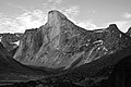 Mount Thor and its steep cliff
 -
 Hiking north towards Thor Peak, July 2007
 -
 Mount Thor on the rim of Akshayuk Pass, showing the U-shaped glacial valley


See also
[edit]- Trango Towers – the tallest near-vertical drop on Earth
- Cerro Torre
- Half Dome
References
[edit]- ^ a b c "Thor Peak". Bivouac.com. Retrieved 30 November 2009.
- ^ a b c "Thor Peak". Geographical Names Data Base. Natural Resources Canada.
- ^ a b "Qairsualuk". ᐃᓄᒃᑎᑐᑦ ᐃᓕᓐᓂᐊᖅᑕ. inuktitutilinniaqta.com. 31 May 2018. Retrieved 3 July 2020.
- ^ Slaymaker, Olav; Catto, Norm (2020). Landscapes and Landforms of Eastern Canada. Springer Nature. p. 4. ISBN 978-3-030-35137-3. Retrieved 3 July 2020.
- ^ Wykes, Tim. "ᐸᓐᓂᖅᑑᖅ Pangnirtung" (PDF). ihti.ca/. Inuit Heritage Trust. Retrieved 3 July 2020.
ᒥ4.2 ᑭᒍᑎᙳᐊᖅ Kigutinnguaq Mountain Looks like a tooth, Mount Thor
- ^ Kazan, Casey (9 March 2010). "Mount Thor -The Greatest Vertical Drop on Earth!". The Daily Galaxy. Archived from the original on 12 March 2010. Retrieved 21 August 2014.
- ^ Jennings, Ken (10 June 2013). "Meet Canada's Mount Thor: The World's Steepest, Tallest Cliff". Conde Nast Traveler. Retrieved 18 April 2015.
- ^ "The Earth Story - geologic blog". Archived from the original on 26 August 2016.
- ^ "Mount Thor, Baffin Island post by Brian John". 13 August 2014.
- ^ Ostriker, J. P. (2007). "Lyman Spitzer. 26 June 1914 -- 31 March 1997: Elected ForMemRS 1990". Biographical Memoirs of Fellows of the Royal Society. 53: 339–348. doi:10.1098/rsbm.2007.0020.
- ^ Morton, Donald C. (1966). "Mt. Asgard And Mt. Thor". Canadian Alpine Journal. 49: 42–48. Archived from the original on 23 September 2018.
- ^ Redfern, Earl (December 1995), "-Mount Thor - 33 Days on the West Face", Climbing Magazine (93): 34–36, ISSN 0045-7159
- ^ North America, Canada, Canadian Arctic, Thor, West Face Solo, AAC Publications, 1989, retrieved 10 March 2026
- ^ North America, Canada, Baffin Island, Auyuittuq National Park, Mt. Thor, Midgard Serpent, Solo Ascent, AAC Publications, 1999, retrieved 10 March 2026
- ^ "Climber Bill Borger". Radio Canada. 24 July 2012. Retrieved 28 August 2012.
- ^ Hummel, Will (3 August 2012), "New route on Baffin Island's Mount Thor", Rock and Ice, archived from the original on 8 August 2012, retrieved 28 August 2012
External links
[edit]- Above the Arctic Circle: Trekking across Canada's Baffin Island at the Wayback Machine (archived 30 January 2009) about Mt. Thor and other Akshayuk Pass features by writer Dave Levinthal