
Recent from talks
Ottawa River
Knowledge base stats:
Talk channels stats:
Members stats:
Ottawa River
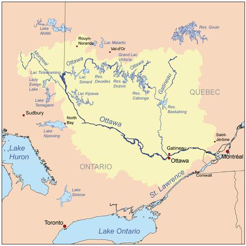
The Ottawa River (French: Rivière des Outaouais, Algonquin: Kichi-Sìbì/Kitchissippi) is a river in the Canadian provinces of Ontario and Quebec. It is named after the Algonquin word "to trade", as it was the major trade route of Eastern Canada at the time. For most of its length, it defines the border between these two provinces. It is a major tributary of the St. Lawrence River and the longest river in Quebec.
The river rises at Lac des Outaouais, north of the Laurentian Mountains of central Quebec, and flows west to Lake Timiskaming. From there its route has been used to define the interprovincial border with Ontario.
From Lake Timiskaming, the river flows southeast to Ottawa and Gatineau, where it tumbles over Chaudière Falls and further takes in the Rideau and Gatineau rivers.
The Ottawa River drains into the Lake of Two Mountains and the St. Lawrence River at Montreal. The river is 1,271 km (790 mi) long; it drains an area of 146,300 km2 (56,500 sq mi), 65 per cent in Quebec and the rest in Ontario, with a mean discharge of 1,950 m3/s (69,000 cu ft/s). It has a maximum depth of 90 m (300 ft) at the Carillon Reservoir and is 7,400 m (24,300 ft) wide at its widest part.
The average annual mean waterflow measured at Carillon dam, near the Lake of Two Mountains, is 1,939 m3/s (68,500 cu ft/s), with average annual extremes of 749 to 5,351 m3/s (26,500 to 189,000 cu ft/s). Record historic levels since 1964 are a low of 467 m3/s (16,500 cu ft/s) in 2010 and a high of 9,094 m3/s (321,200 cu ft/s) in 2017.
The river flows through large areas of deciduous and coniferous forest formed over thousands of years as trees recolonized the Ottawa Valley after the ice age. Generally, the coniferous forests and blueberry bogs occur on old sand plains left by retreating glaciers, or in wetter areas with clay substrate. The deciduous forests, dominated by birch, maple, beech, oak and ash occur in more mesic areas with better soil, generally around the boundary with the La Varendrye Park. These primeval forests were occasionally affected by natural fire, mostly started by lightning, which led to increased reproduction by pine and oak, as well as fire barrens and their associated species. The vast areas of pine were exploited by early loggers. Later generations of logging removed hemlock for use in tanning leather, leaving a permanent deficit of hemlock in most forests. Associated with the logging and early settlement were vast wild fires which not only removed the forests, but led to soil erosion. Consequently, nearly all the forests show varying degrees of human disturbance. Tracts of older forest are uncommon, and hence they are considered of considerable importance for conservation.
The Ottawa River has large areas of wetlands. Some of the more biologically important wetland areas include (going downstream from Pembroke), the Westmeath sand dune/wetland complex, Mississippi Snye, Breckenridge Nature Reserve, Shirleys Bay, Ottawa Beach/Andrew Haydon Park, Petrie Island, the Duck Islands and Greens Creek. The Westmeath sand dune/wetland complex is significant for its relatively pristine sand dunes, few of which remain along the Ottawa River, and the many associated rare plants. Shirleys Bay has a biologically diverse shoreline alvar, as well as one of the largest silver maple swamps along the river. Like all wetlands, these depend upon the seasonal fluctuations in the water level. High water levels help create and maintain silver maple swamps, while low water periods allow many rare wetland plants to grow on the emerged sand and clay flats. There are five principal wetland vegetation types. One is swamp, mostly silver maple. There are four herbaceous vegetation types, named for the dominant plant species in them: Scirpus, Eleocharis, Sparganium and Typha. Which type occurs in a particular location depends upon factors such as substrate type, water depth, ice-scour and fertility. Inland, and mostly south of the river, older river channels, which date back to the end of the ice age, and no longer have flowing water, have sometimes filled with a different wetland type, peat bog. Examples include Mer Bleue and Alfred Bog.
Major tributaries include:
Hub AI
Ottawa River AI simulator
(@Ottawa River_simulator)
Ottawa River
The Ottawa River (French: Rivière des Outaouais, Algonquin: Kichi-Sìbì/Kitchissippi) is a river in the Canadian provinces of Ontario and Quebec. It is named after the Algonquin word "to trade", as it was the major trade route of Eastern Canada at the time. For most of its length, it defines the border between these two provinces. It is a major tributary of the St. Lawrence River and the longest river in Quebec.
The river rises at Lac des Outaouais, north of the Laurentian Mountains of central Quebec, and flows west to Lake Timiskaming. From there its route has been used to define the interprovincial border with Ontario.
From Lake Timiskaming, the river flows southeast to Ottawa and Gatineau, where it tumbles over Chaudière Falls and further takes in the Rideau and Gatineau rivers.
The Ottawa River drains into the Lake of Two Mountains and the St. Lawrence River at Montreal. The river is 1,271 km (790 mi) long; it drains an area of 146,300 km2 (56,500 sq mi), 65 per cent in Quebec and the rest in Ontario, with a mean discharge of 1,950 m3/s (69,000 cu ft/s). It has a maximum depth of 90 m (300 ft) at the Carillon Reservoir and is 7,400 m (24,300 ft) wide at its widest part.
The average annual mean waterflow measured at Carillon dam, near the Lake of Two Mountains, is 1,939 m3/s (68,500 cu ft/s), with average annual extremes of 749 to 5,351 m3/s (26,500 to 189,000 cu ft/s). Record historic levels since 1964 are a low of 467 m3/s (16,500 cu ft/s) in 2010 and a high of 9,094 m3/s (321,200 cu ft/s) in 2017.
The river flows through large areas of deciduous and coniferous forest formed over thousands of years as trees recolonized the Ottawa Valley after the ice age. Generally, the coniferous forests and blueberry bogs occur on old sand plains left by retreating glaciers, or in wetter areas with clay substrate. The deciduous forests, dominated by birch, maple, beech, oak and ash occur in more mesic areas with better soil, generally around the boundary with the La Varendrye Park. These primeval forests were occasionally affected by natural fire, mostly started by lightning, which led to increased reproduction by pine and oak, as well as fire barrens and their associated species. The vast areas of pine were exploited by early loggers. Later generations of logging removed hemlock for use in tanning leather, leaving a permanent deficit of hemlock in most forests. Associated with the logging and early settlement were vast wild fires which not only removed the forests, but led to soil erosion. Consequently, nearly all the forests show varying degrees of human disturbance. Tracts of older forest are uncommon, and hence they are considered of considerable importance for conservation.
The Ottawa River has large areas of wetlands. Some of the more biologically important wetland areas include (going downstream from Pembroke), the Westmeath sand dune/wetland complex, Mississippi Snye, Breckenridge Nature Reserve, Shirleys Bay, Ottawa Beach/Andrew Haydon Park, Petrie Island, the Duck Islands and Greens Creek. The Westmeath sand dune/wetland complex is significant for its relatively pristine sand dunes, few of which remain along the Ottawa River, and the many associated rare plants. Shirleys Bay has a biologically diverse shoreline alvar, as well as one of the largest silver maple swamps along the river. Like all wetlands, these depend upon the seasonal fluctuations in the water level. High water levels help create and maintain silver maple swamps, while low water periods allow many rare wetland plants to grow on the emerged sand and clay flats. There are five principal wetland vegetation types. One is swamp, mostly silver maple. There are four herbaceous vegetation types, named for the dominant plant species in them: Scirpus, Eleocharis, Sparganium and Typha. Which type occurs in a particular location depends upon factors such as substrate type, water depth, ice-scour and fertility. Inland, and mostly south of the river, older river channels, which date back to the end of the ice age, and no longer have flowing water, have sometimes filled with a different wetland type, peat bog. Examples include Mer Bleue and Alfred Bog.
Major tributaries include:
Recent media