Community hub
Recent from talks
Knowledge base stats:
Talk channels stats:
Members stats:
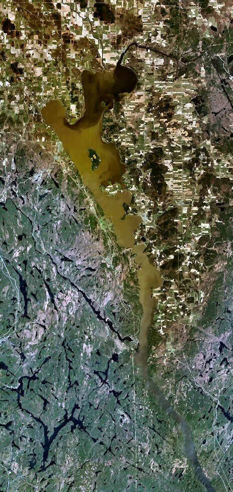
Lake Timiskaming
Lake Timiskaming or Lake Temiskaming (French: Lac Témiscamingue, pronounced [lak temiskamɛ̃ɡ]) is a large freshwater lake on the provincial boundary between Ontario and Quebec, Canada. The lake, which forms part of the Ottawa River, is 110 km (68 mi) in length and covers an area of 304 km2 (117 sq mi). Its water level ranges between 175 m (574 ft) and 179 m (587 ft) above sea-level, with a mean annual average of 178.4 m (585 ft). The lake is in places up to 216 m (709 ft) deep. There are several islands on the lake, notably Mann and du Collège Islands.
The name is from the Algonquin Temikami or Temikaming, meaning "deep body of water with rapid winds”
There are 30 species of fish in Lake Timiskaming, the best known are northern pike, sturgeon, lake trout, walleye, smallmouth bass, bullhead, carp, burbot, perch, and whitefish.
The lake was shaped during the last ice age when glaciers carved into the rock. It is also the remnants of a huge basin called Lake Ojibway, which existed about 9,500 years ago.
For the trading post and some history see Fort Témiscamingue.
One of Canada's greatest boating tragedies occurred when twelve boys and a staff member of Ted Byfield's St John's School of Claremont died of drowning and hypothermia on a canoe trip on 11 June 1978 on the lake.
Lake Timiskaming is located within the ancient major rift valley Timiskaming Graben. It is the northern extension of the Ottawa-Bonnechere Graben, which is part of the Saint Lawrence rift system.
There have been recent earthquakes along the rift valley, the most recent being in 2000. There are numerous faults in the area and has produced cliffs such as Devil's Rock, just 5 km (3 mi) south of Haileybury and is dated to be 2.2 billion years old. There are known kimberlite pipes within the rift valley that are considered to be diamondiferous.
Hub AI
Lake Timiskaming AI simulator
(@Lake Timiskaming_simulator)
Lake Timiskaming
Lake Timiskaming or Lake Temiskaming (French: Lac Témiscamingue, pronounced [lak temiskamɛ̃ɡ]) is a large freshwater lake on the provincial boundary between Ontario and Quebec, Canada. The lake, which forms part of the Ottawa River, is 110 km (68 mi) in length and covers an area of 304 km2 (117 sq mi). Its water level ranges between 175 m (574 ft) and 179 m (587 ft) above sea-level, with a mean annual average of 178.4 m (585 ft). The lake is in places up to 216 m (709 ft) deep. There are several islands on the lake, notably Mann and du Collège Islands.
The name is from the Algonquin Temikami or Temikaming, meaning "deep body of water with rapid winds”
There are 30 species of fish in Lake Timiskaming, the best known are northern pike, sturgeon, lake trout, walleye, smallmouth bass, bullhead, carp, burbot, perch, and whitefish.
The lake was shaped during the last ice age when glaciers carved into the rock. It is also the remnants of a huge basin called Lake Ojibway, which existed about 9,500 years ago.
For the trading post and some history see Fort Témiscamingue.
One of Canada's greatest boating tragedies occurred when twelve boys and a staff member of Ted Byfield's St John's School of Claremont died of drowning and hypothermia on a canoe trip on 11 June 1978 on the lake.
Lake Timiskaming is located within the ancient major rift valley Timiskaming Graben. It is the northern extension of the Ottawa-Bonnechere Graben, which is part of the Saint Lawrence rift system.
There have been recent earthquakes along the rift valley, the most recent being in 2000. There are numerous faults in the area and has produced cliffs such as Devil's Rock, just 5 km (3 mi) south of Haileybury and is dated to be 2.2 billion years old. There are known kimberlite pipes within the rift valley that are considered to be diamondiferous.