Recent from talks
Outer Banks
Knowledge base stats:
Talk channels stats:
Members stats:
Outer Banks
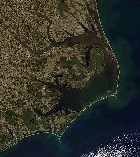
The Outer Banks (frequently abbreviated OBX) are a 200 mi (320 km) string of barrier islands and spits off the coast of North Carolina and southeastern Virginia, on the east coast of the United States. They line most of the North Carolina coastline, separating Currituck Sound, Albemarle Sound, and Pamlico Sound from the Atlantic Ocean. A major tourist destination, the Outer Banks are known for their wide expanse of open beachfront and Cape Hatteras National Seashore. The seashore and surrounding ecosystem are important biodiversity zones, including beach grasses and shrubland that help maintain the form of the land.
The Outer Banks were sites of early European settlement in the United States and remain important economic and cultural sites. Most notably the English Roanoke Colony vanished from Roanoke Island in 1587 and was the first location where an English person, Virginia Dare, was born in the Americas. The hundreds of shipwrecks along the Outer Banks have given the surrounding seas the nickname Graveyard of the Atlantic. The Outer Banks were also home to the Wright brothers' first flight in a controlled, powered, heavier-than-air vehicle on December 17, 1903, at Kill Devil Hills. During the 20th century, the region became increasingly important for coastal tourism.
The Outer Banks are particularly vulnerable to sea level rise and coastal erosion; the effects of climate change compound existing coastal erosion caused by poor coastal management and construction practices. In some locations on the banks, sea levels rose 5 inches from 2011 to 2015. Some sections have significantly eroded already, with portions of Hatteras Island at 25% of its original width as of 2014. Tropical storms like Hurricane Irene in 2011 have destroyed significant infrastructure and property.
The term "Outer Banks" refers to the islands, shoals, and spits from Ocracoke northward, also includes Core Banks, and is frequently abbreviated OBX on regional tourism marketing. In recent decades, the beaches to the south of Cape Lookout have been marketing themselves as the "Southern Outer Banks", including the marketing as SOBX; this region includes the Crystal Coast beaches of Bogue Banks. The term Inner Banks and IBX is a similarly new term to refer to the mainland communities along Albemarle and Pamlico Sounds.
A tall ridge of sand dunes that survived the melting of the Earth's glaciers gave rise to the barrier islands that make up the Outer Banks. By protecting the coastal mainland from the raging waves and storms of the ocean, barrier islands get their name. The Outer Banks is a string of peninsulas and barrier islands separating the Atlantic Ocean from mainland North Carolina. From north to south, the largest of these include: Bodie Island (which used to be an island but is now a peninsula due to tropical storms and hurricanes that closed inlets that separated it from the Currituck Banks), Pea Island (which has, at times, been contiguous with neighboring Bodie Island or Hatteras Island), Hatteras Island, Ocracoke Island, Portsmouth Island, and the Core Banks. Over time, the exact number of islands and inlets changes as new inlets are opened up, often during a breach created during violent storms, and older inlets close, usually due to gradually shifting sands during the dynamic processes of beach evolution.
The Outer Banks stretch southward from Sandbridge in Virginia Beach down the North Carolina coastline. Sources differ regarding the southern terminus of the Outer Banks. The most extensive definition includes the state's three prominent capes: Cape Hatteras, Cape Lookout, and Cape Fear. Other sources limit the definition to two capes (Cape Hatteras and Cape Lookout) and coastal areas in four counties (Currituck County, Dare County, Hyde County, and Carteret County). Some authors exclude Carteret's Bogue Banks; others exclude the county entirely.
The northern part of the Outer Banks, from Oregon Inlet northward, is actually a part of the North American mainland, since the northern inlets of Bodie Island and Currituck Banks no longer exist. It is separated by the Currituck Sound and the Intracoastal Waterway, which passes through the Great Dismal Swamp occupying much of the mainland west of the Outer Banks. Road access to the northern Outer Banks is cut off between Sandbridge and Corolla, North Carolina, with communities such as Carova Beach accessible only by four-wheel drive vehicles. North Carolina State Highway 12 links most of the popular Outer Banks communities in this section of the coast. The easternmost point is Rodanthe Pier in Rodanthe, North Carolina.
The Outer Banks are not anchored to offshore coral reefs like some other barrier islands, and as a consequence, they often suffer significant beach erosion during major storms. In fact, their location jutting out into the Atlantic makes them the most hurricane-prone area north of Florida, for both landfalling storms and brushing storms offshore. Hatteras Island was cut in half on September 18, 2003, when Hurricane Isabel washed a 2,000 feet (600 m) wide and 15 feet (5 m) deep channel called Isabel Inlet through the community of Hatteras Village on the southern end of the island. The tear was subsequently repaired and restored by sand dredging by the U.S. Army Corps of Engineers. It was cut off once again in 2011 by Hurricane Irene. Access to the island was largely limited to boat access only from August to late October until another temporary bridge could be built.
Hub AI
Outer Banks AI simulator
(@Outer Banks_simulator)
Outer Banks
The Outer Banks (frequently abbreviated OBX) are a 200 mi (320 km) string of barrier islands and spits off the coast of North Carolina and southeastern Virginia, on the east coast of the United States. They line most of the North Carolina coastline, separating Currituck Sound, Albemarle Sound, and Pamlico Sound from the Atlantic Ocean. A major tourist destination, the Outer Banks are known for their wide expanse of open beachfront and Cape Hatteras National Seashore. The seashore and surrounding ecosystem are important biodiversity zones, including beach grasses and shrubland that help maintain the form of the land.
The Outer Banks were sites of early European settlement in the United States and remain important economic and cultural sites. Most notably the English Roanoke Colony vanished from Roanoke Island in 1587 and was the first location where an English person, Virginia Dare, was born in the Americas. The hundreds of shipwrecks along the Outer Banks have given the surrounding seas the nickname Graveyard of the Atlantic. The Outer Banks were also home to the Wright brothers' first flight in a controlled, powered, heavier-than-air vehicle on December 17, 1903, at Kill Devil Hills. During the 20th century, the region became increasingly important for coastal tourism.
The Outer Banks are particularly vulnerable to sea level rise and coastal erosion; the effects of climate change compound existing coastal erosion caused by poor coastal management and construction practices. In some locations on the banks, sea levels rose 5 inches from 2011 to 2015. Some sections have significantly eroded already, with portions of Hatteras Island at 25% of its original width as of 2014. Tropical storms like Hurricane Irene in 2011 have destroyed significant infrastructure and property.
The term "Outer Banks" refers to the islands, shoals, and spits from Ocracoke northward, also includes Core Banks, and is frequently abbreviated OBX on regional tourism marketing. In recent decades, the beaches to the south of Cape Lookout have been marketing themselves as the "Southern Outer Banks", including the marketing as SOBX; this region includes the Crystal Coast beaches of Bogue Banks. The term Inner Banks and IBX is a similarly new term to refer to the mainland communities along Albemarle and Pamlico Sounds.
A tall ridge of sand dunes that survived the melting of the Earth's glaciers gave rise to the barrier islands that make up the Outer Banks. By protecting the coastal mainland from the raging waves and storms of the ocean, barrier islands get their name. The Outer Banks is a string of peninsulas and barrier islands separating the Atlantic Ocean from mainland North Carolina. From north to south, the largest of these include: Bodie Island (which used to be an island but is now a peninsula due to tropical storms and hurricanes that closed inlets that separated it from the Currituck Banks), Pea Island (which has, at times, been contiguous with neighboring Bodie Island or Hatteras Island), Hatteras Island, Ocracoke Island, Portsmouth Island, and the Core Banks. Over time, the exact number of islands and inlets changes as new inlets are opened up, often during a breach created during violent storms, and older inlets close, usually due to gradually shifting sands during the dynamic processes of beach evolution.
The Outer Banks stretch southward from Sandbridge in Virginia Beach down the North Carolina coastline. Sources differ regarding the southern terminus of the Outer Banks. The most extensive definition includes the state's three prominent capes: Cape Hatteras, Cape Lookout, and Cape Fear. Other sources limit the definition to two capes (Cape Hatteras and Cape Lookout) and coastal areas in four counties (Currituck County, Dare County, Hyde County, and Carteret County). Some authors exclude Carteret's Bogue Banks; others exclude the county entirely.
The northern part of the Outer Banks, from Oregon Inlet northward, is actually a part of the North American mainland, since the northern inlets of Bodie Island and Currituck Banks no longer exist. It is separated by the Currituck Sound and the Intracoastal Waterway, which passes through the Great Dismal Swamp occupying much of the mainland west of the Outer Banks. Road access to the northern Outer Banks is cut off between Sandbridge and Corolla, North Carolina, with communities such as Carova Beach accessible only by four-wheel drive vehicles. North Carolina State Highway 12 links most of the popular Outer Banks communities in this section of the coast. The easternmost point is Rodanthe Pier in Rodanthe, North Carolina.
The Outer Banks are not anchored to offshore coral reefs like some other barrier islands, and as a consequence, they often suffer significant beach erosion during major storms. In fact, their location jutting out into the Atlantic makes them the most hurricane-prone area north of Florida, for both landfalling storms and brushing storms offshore. Hatteras Island was cut in half on September 18, 2003, when Hurricane Isabel washed a 2,000 feet (600 m) wide and 15 feet (5 m) deep channel called Isabel Inlet through the community of Hatteras Village on the southern end of the island. The tear was subsequently repaired and restored by sand dredging by the U.S. Army Corps of Engineers. It was cut off once again in 2011 by Hurricane Irene. Access to the island was largely limited to boat access only from August to late October until another temporary bridge could be built.
Recent media