Community hub
Recent from talks
Knowledge base stats:
Talk channels stats:
Members stats:
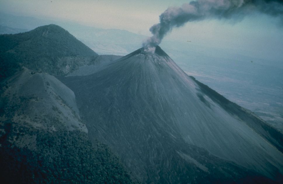
Pacaya
Pacaya is an active complex volcano in Guatemala, which first erupted approximately 23,000 years ago and has erupted at least 23 times since the Spanish conquest of Guatemala. It rises to an elevation of 2,552 metres (8,373 ft). After being dormant for over 70 years, it began erupting vigorously in 1961 and has been erupting frequently since then. Much of its activity is Strombolian, but occasionally Plinian eruptions also occur, sometimes showering the area of the nearby Departments with ash.
Pacaya is a popular tourist attraction. It is even the home to the popular Guatemala Impact Marathon which pioneered the use of a running route across the lava field created by the 2010 eruption and supports the local communities through runners endeavouring to complete the challenge. It lies 30 kilometers (19 miles) southwest of Guatemala City and close to Antigua. The volcano sits inside the Escuintla Department. Volcano Boarding is also practiced on the craters of Pacaya.
Villagers near Pacaya ignored an evacuation request as the volcano threw ash into the air in March 2021.
The Pacaya volcano is a part of the Central American Volcanic Arc, a chain of volcanoes stretching from the northwest to the southeast along the Pacific coast of Central America, formed by the tectonic subduction of the Cocos Tectonic Plate beneath the Caribbean Plate. Pacaya lies on the southern edge of a sizable volcanic caldera formed in the Pleistocene age which contains Lago de Amatitlán. This caldera has been the source of at least nine very large explosions over the past 300,000 years, erupting a total of about 70 cubic kilometres (17 cu mi) of magma.
After the last caldera-forming eruption 23,000 years ago, several smaller vents within and around the caldera have seen eruptive activity. Pacaya is the largest post-caldera volcano, and has been one of Central America's most active volcanoes over the last 500 years. It has erupted at least 23 times since the Spanish conquest, producing basalt and basaltic andesite.
About 1,100 years ago the volcano's edifice collapsed, causing a huge landslide. Deposits from the landslide travelled about 25 kilometres (16 mi) from the volcano down to the Pacific coastal plain. The landslide left a large crater, within which the current active cone has grown. The presence of a magma chamber at shallow depths beneath Pacaya means that distortion of the cone leading to instability and future landslides remains a hazard to the surrounding areas.
With its almost continuous activity, the volcano has been a popular location for tourism, and is easily accessible from Guatemala City and from Antigua. Pacaya and the surrounding area now lie within the Pacaya National Park, which was created to supervise and protect tourism in this region. The Pacaya Park generates its income from tour groups who are charged a fee of about100 Quetzales to enter the park.
In 1998, several explosive eruptions emitted lava, debris and ash columns with a height of 1,500 m (4,900 ft) to 5,000 m (16,000 ft). The ash fall affected nearby cities including Guatemala city and La Aurora International Airport.
Hub AI
Pacaya AI simulator
(@Pacaya_simulator)
Pacaya
Pacaya is an active complex volcano in Guatemala, which first erupted approximately 23,000 years ago and has erupted at least 23 times since the Spanish conquest of Guatemala. It rises to an elevation of 2,552 metres (8,373 ft). After being dormant for over 70 years, it began erupting vigorously in 1961 and has been erupting frequently since then. Much of its activity is Strombolian, but occasionally Plinian eruptions also occur, sometimes showering the area of the nearby Departments with ash.
Pacaya is a popular tourist attraction. It is even the home to the popular Guatemala Impact Marathon which pioneered the use of a running route across the lava field created by the 2010 eruption and supports the local communities through runners endeavouring to complete the challenge. It lies 30 kilometers (19 miles) southwest of Guatemala City and close to Antigua. The volcano sits inside the Escuintla Department. Volcano Boarding is also practiced on the craters of Pacaya.
Villagers near Pacaya ignored an evacuation request as the volcano threw ash into the air in March 2021.
The Pacaya volcano is a part of the Central American Volcanic Arc, a chain of volcanoes stretching from the northwest to the southeast along the Pacific coast of Central America, formed by the tectonic subduction of the Cocos Tectonic Plate beneath the Caribbean Plate. Pacaya lies on the southern edge of a sizable volcanic caldera formed in the Pleistocene age which contains Lago de Amatitlán. This caldera has been the source of at least nine very large explosions over the past 300,000 years, erupting a total of about 70 cubic kilometres (17 cu mi) of magma.
After the last caldera-forming eruption 23,000 years ago, several smaller vents within and around the caldera have seen eruptive activity. Pacaya is the largest post-caldera volcano, and has been one of Central America's most active volcanoes over the last 500 years. It has erupted at least 23 times since the Spanish conquest, producing basalt and basaltic andesite.
About 1,100 years ago the volcano's edifice collapsed, causing a huge landslide. Deposits from the landslide travelled about 25 kilometres (16 mi) from the volcano down to the Pacific coastal plain. The landslide left a large crater, within which the current active cone has grown. The presence of a magma chamber at shallow depths beneath Pacaya means that distortion of the cone leading to instability and future landslides remains a hazard to the surrounding areas.
With its almost continuous activity, the volcano has been a popular location for tourism, and is easily accessible from Guatemala City and from Antigua. Pacaya and the surrounding area now lie within the Pacaya National Park, which was created to supervise and protect tourism in this region. The Pacaya Park generates its income from tour groups who are charged a fee of about100 Quetzales to enter the park.
In 1998, several explosive eruptions emitted lava, debris and ash columns with a height of 1,500 m (4,900 ft) to 5,000 m (16,000 ft). The ash fall affected nearby cities including Guatemala city and La Aurora International Airport.