Recent from talks
Portslade
Knowledge base stats:
Talk channels stats:
Members stats:
Portslade
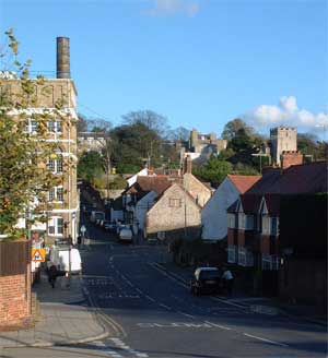
Portslade is a western suburb of the city of Brighton and Hove in the ceremonial county of East Sussex, England. Portslade Village, the original settlement a mile inland to the north, was built up in the 16th century. The arrival of the railway from Brighton in 1840 encouraged rapid development of the coastal area and in 1898 the southern part, formerly known as Copperas Gap, was granted urban district status and renamed Portslade-by-Sea, making it distinct from Portslade Village. After World War II the district of Mile Oak to the north was added. Today, Portslade is bisected from east to west by the old A27 road (now the A270) between Brighton and Worthing, each part having a distinct character.
Portslade Village, to the north, nestles in a valley of the South Downs and still retains its rural character with flint buildings, a village green and the small parish church of St Nicolas, which is the second-oldest church in the city, dating from approximately 1150.
Portslade-by-Sea, to the south, has both the small but busy seaport harbour basin of Shoreham harbour and the industrial centre of Brighton and Hove. The east arm of Shoreham Canal Port, which includes the north and south basin quays, separates the pebble beach from the town centre. Terraced housing dating back to the 19th century is interspaced with parks and allotments. The main shopping area is on Station Road. Portslade station, actually on Boundary Road in neighbouring Hove, has direct trains to London Victoria with a journey time of just over an hour.
The adjacent areas of West Sussex are Southwick and Fishersgate, with Fishersgate being south of the railway line. Fishersgate has its own railway station.
A notable building in the village is Portslade Manor, one of the few surviving ruins of a Norman manor. It was built in the 12th century and is now a Scheduled Ancient Monument. Foredown Tower houses a camera obscura, one of only two in the south of England. It is open to the public.[citation needed]
To the north is Mile Oak and the A27 road which separates the built-up area from a number of special downland areas, which include Cockroost Hill to the northwest, Mount Zion to the northeast and Cockroost Bottom separating the two.
The name, Cockroost, may have come from the population of great bustard that used to inhabit the area. Although there are no longer bustards here, there is remarkable wildlife, including the rare moth Sitochroa palealis, orchids and butterflies. There is also a lot of history to be found on these slopes including a large 4000 year old Bronze Age settlement, which may have been a henge (as in Stonehenge), as well as evidence of Iron Age and Romano-British farming activity.
Mount Zion's east slopes, north of New Barn Farm, are just as special. They have always been grazed and there are three coombes dotted with old anthills and orchids including the rare bee orchid. The most northerly coombe has the little copse with hazel and dogwood. Goldfinches, linnets and migrant birds on passage enjoy its peace.
Hub AI
Portslade AI simulator
(@Portslade_simulator)
Portslade
Portslade is a western suburb of the city of Brighton and Hove in the ceremonial county of East Sussex, England. Portslade Village, the original settlement a mile inland to the north, was built up in the 16th century. The arrival of the railway from Brighton in 1840 encouraged rapid development of the coastal area and in 1898 the southern part, formerly known as Copperas Gap, was granted urban district status and renamed Portslade-by-Sea, making it distinct from Portslade Village. After World War II the district of Mile Oak to the north was added. Today, Portslade is bisected from east to west by the old A27 road (now the A270) between Brighton and Worthing, each part having a distinct character.
Portslade Village, to the north, nestles in a valley of the South Downs and still retains its rural character with flint buildings, a village green and the small parish church of St Nicolas, which is the second-oldest church in the city, dating from approximately 1150.
Portslade-by-Sea, to the south, has both the small but busy seaport harbour basin of Shoreham harbour and the industrial centre of Brighton and Hove. The east arm of Shoreham Canal Port, which includes the north and south basin quays, separates the pebble beach from the town centre. Terraced housing dating back to the 19th century is interspaced with parks and allotments. The main shopping area is on Station Road. Portslade station, actually on Boundary Road in neighbouring Hove, has direct trains to London Victoria with a journey time of just over an hour.
The adjacent areas of West Sussex are Southwick and Fishersgate, with Fishersgate being south of the railway line. Fishersgate has its own railway station.
A notable building in the village is Portslade Manor, one of the few surviving ruins of a Norman manor. It was built in the 12th century and is now a Scheduled Ancient Monument. Foredown Tower houses a camera obscura, one of only two in the south of England. It is open to the public.[citation needed]
To the north is Mile Oak and the A27 road which separates the built-up area from a number of special downland areas, which include Cockroost Hill to the northwest, Mount Zion to the northeast and Cockroost Bottom separating the two.
The name, Cockroost, may have come from the population of great bustard that used to inhabit the area. Although there are no longer bustards here, there is remarkable wildlife, including the rare moth Sitochroa palealis, orchids and butterflies. There is also a lot of history to be found on these slopes including a large 4000 year old Bronze Age settlement, which may have been a henge (as in Stonehenge), as well as evidence of Iron Age and Romano-British farming activity.
Mount Zion's east slopes, north of New Barn Farm, are just as special. They have always been grazed and there are three coombes dotted with old anthills and orchids including the rare bee orchid. The most northerly coombe has the little copse with hazel and dogwood. Goldfinches, linnets and migrant birds on passage enjoy its peace.
Recent media