Hubbry Logo
HengeHengeMain
Open search
Henge
Community hub
Henge
logo
8 pages, 0 posts
0 subscribers
Be the first to start a discussion here.
Henge
Henge
from Wikipedia
The three aligned henges of the Thornborough Henges complex

A henge can be one of three related types of Neolithic earthwork. The essential characteristic of all three is that they feature a ring-shaped bank and ditch, with the ditch inside the bank. Because the internal ditches would have served defensive purposes poorly, henges are not considered to have been defensive constructions (cf. circular rampart).

The three henge types (figures in brackets indicate the approximate diameter of the central flat area) are:

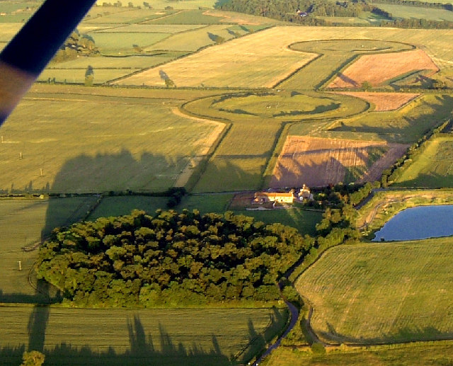
  1. Henge (> 20 m (65 ft)).[1] The word henge refers to a particular type of earthwork of the Neolithic period, typically consisting of a roughly circular or oval-shaped bank with an internal ditch surrounding a central flat area of more than 20 m (66 ft) in diameter. There is typically little if any evidence of occupation in a henge, although they may contain ritual structures such as stone circles, timber circles and coves. Henge monument is sometimes used as a synonym for henge. Henges sometimes, but by no means always, featured stone or timber circles, and circle henge is sometimes used to describe these structures. The three largest stone circles in Britain (Avebury, the Great Circle at Stanton Drew stone circles, and the Ring of Brodgar) are each within a henge. Examples of henges without significant internal monuments are the three henges of Thornborough Henges. Although having given its name to the word henge, Stonehenge is atypical in that the ditch is outside the main earthwork bank.
  2. Hengiform monument (5–20 m (15–65 ft)).[2] Like an ordinary henge, except the central flat area is between 5 and 20 m (16–66 ft) in diameter, they comprise a modest earthwork with a fairly wide outer bank. The terms mini-henge (also minihenge) or Dorchester henge are sometimes used as synonyms for hengiform monument. An example is the Neolithic site at Wormy Hillock Henge.
  3. Henge enclosure (> 300 m (1,000 ft)).[3] A Neolithic ring earthwork with the ditch inside the bank, with the central flat area having abundant evidence of occupation and usually being more than 300 m (980 ft) in diameter. Some true henges are as large as this (e.g., Avebury), but lack evidence of domestic occupation. Mega henge, Super-henge or superhenge is sometimes used as a synonym for a henge enclosure. Sometimes the term is used to indicate size alone rather than use, e.g. "Marden henge ... is the least understood of the four British 'superhenges' (the others being Avebury, Durrington Walls and Mount Pleasant Henge)".[4][5]

Etymology

[edit]

The word henge is a backformation from Stonehenge, the famous monument in Wiltshire.[6] The term was first coined in 1932 by Thomas Kendrick, who later became the Keeper of British Antiquities at the British Museum.[7][8][9] A broader usage of henge to refer to standing-stone monuments was recorded in Yorkshire in 1740, from Old English usage dating to at least the 10th century,[10] with a root of either hencg 'hinge', or hen(c)en 'to hang, to suspend'.[11]

Stonehenge is not a true henge, as its ditch runs outside its bank, although there is a small extant external bank as well.

Forms

[edit]
Avebury henge contains several stone circles

Henges may be classified as follows:

  • Class I henges, which have a single entrance created from a gap in the bank;
  • Class II henges which have two entrances, diametrically opposite each other;
  • Class III henges, which have four entrances, facing each other in pairs.

Sub groups exist for these when two or three internal ditches are present rather than one.[12] Henges are usually associated with the Late Neolithic or Early Bronze Age, and especially with the pottery of this period: Grooved Ware, Impressed Wares (formerly known as Peterborough Ware), and Beakers. Sites such as Stonehenge also provide evidence of activity from the later Bronze Age Wessex culture.

A lidar view of the henge at Newton Kyme and other features in Yorkshire

Henges often contain evidence of a variety of internal features, including timber or stone circles, pits, or burials, which may pre- or post-date the henge enclosure. A henge should not be confused with a stone circle within it, as henges and stone circles can exist together or separately.[citation needed] At Arbor Low in Derbyshire, all the stones except one are laid flat and do not seem to have been erected, as no stone holes have been found. Elsewhere, often only the stone holes remain to indicate a former circle.[citation needed]

Some of the best-known henges are at:

Henges sometimes formed part of a ritual landscape or complex, with other Neolithic and Bronze Age monuments inside and outside the henge. Earlier monuments associated with a later henge might include Neolithic monuments such as a cursus (e.g., at Thornborough Henges the central henge overlies the cursus), or a long barrow, such as the West Kennet Long Barrow at Avebury, Wiltshire, or, as in the case of Stonehenge, Mesolithic post holes. A circle of large pits c. 2 km (1+14 mi) across is centered on Durrington Walls henge.[14] Later monuments added after the henge was built might include Bronze Age cairns as at Arbor Low.

An aerial view of the henge site and cairn on Cairnpapple Hill in West Lothian

Examples of such ritual landscapes are:

Burials have been recorded at a number of excavated henges, both pre-dating the henge and as a result of secondary reuse. For example:

Origin and distribution

[edit]
The Ring of Brodgar, Orkney, is a possible area of origin for henges

Efforts to delineate a direct lineage for the henge from earlier enclosures have not been conclusive. Their chronological overlap with older structures makes it difficult to classify them as a coherent tradition. They seem to take the concept of creating a space separate from the outside world one step further than the causewayed enclosure, and they focus attention on an internal point. In some cases, the construction of the bank and ditch was a stage that followed other activity on the site. At Balfarg, North Mains, and Cairnpapple, for example, earlier cremations and deliberate smashing of pottery predate the enclosure.

Concentrations of henges occur over much of Britain. Orkney (Cunliffe 2001) and Wessex (Burl 1969) have both been suggested as the original provenance of the monument type; however, others remain unconvinced (Barclay 2005). Unlike earlier enclosure monuments, henges were not usually built on hilltops but on low-lying ground, often close to watercourses and good agricultural land.

Some scholars, such as the editors of the 1982 edition of the Penguin Dictionary of Archaeology (Bray and Trump, 1982), have claimed that henges are unique to the British Isles. They state that similar, much earlier, circles on the European continent, such as Goseck circle (which has no bank), and later ones such as Goloring are not proper "henges". But The Penguin Archaeological Guide (Bahn, 2001) does not comment on geographical locations for henges.

Excavated henge ditch on Wyke Down (Dorset). The ditch was originally dug as a causewayed enclosure and may therefore not be a henge.

Julian Cope, in The Megalithic European,[21] proposes that the henge was a regional development from the Europe-wide causewayed enclosure. He notes it appeared following a cultural upheaval in around 3000 BC, which inspired the peoples of Neolithic Europe to develop more independently. He notes the rondel enclosures of Bavaria's Isar Valley, which according to investigations by the German archaeologist R. A. Maier, "drew comparisons with the henge monuments and causewayed enclosures of the British Isles." Although still with a multiple-causewayed ditch and entrances at cardinal points, the roundels are described by John Hodgson (2003) as not being positioned with defensive aims in mind. The largest, at Kothingeichendorf, appeared to be "midway between a henge and a causewayed enclosure".

Alasdair Whittle (2005) also views the development of the henge as a regional variation within a European tradition that included a variety of ditched enclosures. He notes that henges and the grooved ware pottery often found at them are two examples of the British Neolithic not found on the Continent. Caroline Malone (2001) also says that henges were not built in the rest of Western Europe, but they developed from a broader tradition of enclosure to become "a phenomenon of the British Isles, a native tradition with sophisticated architecture and calendrical functions."

Interpretation

[edit]

Henges may have been used for rituals or astronomical observation rather than day-to-day activity. That their ditches are located inside their banks indicates that they were not used for defence, and that the barrier of the earthworks was more likely symbolic than functional. Following arguments presented for Irish Iron Age enclosures, Barclay suggested that they are 'defensive': that the ditch and bank face something 'dangerous' inside the enclosure. He has also suggested that the considerable range of elements surrounded by the earthworks, and the very long date range, are because henges were designed mainly to enclose pre-existing ceremonial sites that were seen as 'ritually charged' and therefore dangerous to people. It has been conjectured that whatever took place inside the enclosures was intended to be separate from the outside world and perhaps known only to select individuals or groups.

The alignment of henges is a contentious issue. Popular belief is that their entrances point towards certain heavenly bodies. But henge orientation is highly variable and may have been determined more by local topography than by desire for symbolic orientation. Statistical analysis showed that Class I henges have a slight tendency to have an entrance set in the north or north-east quarter. Class II henges generally have their axes aligned approximately south-east to north-west or north-east to south-west.

It has been suggested that the stone and timber structures sometimes built inside henges were used as solar declinometers to measure the position of the rising or setting sun. These structures do not appear in all henges; and when they do, often they are considerably more recent than the henges. Thus, they are not necessarily connected with the henge's original function. It has been conjectured that the henges would have been used to synchronize a calendar to the solar cycle for purposes of planting crops or timing religious rituals. Some henges have poles, stones or entrances that indicate the position of the rising or setting sun during the equinoxes and solstices, while others appear to frame certain constellations. Additionally, many are placed so that nearby hills either mark or do not interfere with such observations. Finally, some henges appear to be placed at particular latitudes. For example, a number are placed at a latitude of 55 degrees north, where the same two markers can indicate the rising and setting sun for both the spring and autumn equinoxes. But as henges are present from the extreme north to the extreme south of Britain, their latitude could not have been of great importance.

Formalisation is commonly attributed to henges: indications of the builders' concerns to control the arrival at, entrance into, and movement within the enclosures. This was achieved by placing flanking stones or avenues at the entrances of some henges, or by dividing the internal space with timber circles. While some henges were the first monuments to be built in their areas, others were added to already important landscapes, especially the larger examples.

The concentric nature of many of the internal features, such as the five rings of postholes at Balfarg or the six at Woodhenge, may represent a finer distinction than the inside-out differences suggested by henge earthworks. The ordering of space and the circular movement suggested by the sometimes densely packed internal features indicates a sophisticated degree of spatial understanding.

Hengiform monument

[edit]
A near infrared image of the site of a prehistoric timber circle at Beecraigs in West Lothian

Hengiform monuments, or mini henges, are distributed throughout England and mainland Scotland (with examples as far north as Caithness), though no examples have been found in Wales. Pits, cremations, postholes, stone-sockets, and graves have been found within them, and postholes and cremation pits have also been found to be present close to the site in some cases. They typically have either one entrance or two opposing entrances. In plan, a mini henge can be mistaken for a ploughed-out round barrow, although the former tend to be slightly larger and their earthworks more substantial. As with ordinary henges, they are thought to have served ritual purposes and are thought to be of late Neolithic date.

Henge enclosure

[edit]

Henge enclosures often contain or lie close to one or more ordinary henges. Finds of animal bone, grooved ware pottery, and evidence of dwellings have been found and coupled with the time and energy needed to build them, it is considered that they must have been important social centres analogous to tribal capitals. Two or four evenly spaced entrances lead through the earthwork to the centre.

Maelmin Henge, constructed in 2000

Modern henge monuments

[edit]

A henge monument was restored at the Devil's Quoits in Oxfordshire between 2002 and 2008.

In modern times a number of henge type monuments have been built, examples include:

See also

[edit]

References

[edit]

Bibliography

[edit]
[edit]
Revisions and contributorsEdit on WikipediaRead on Wikipedia
from Grokipedia
A henge is a prehistoric consisting of a circular or oval-shaped formed by an earthen surrounded by an internal , typically constructed during the period from around 3000 BC to 2000 BC in Britain and . These structures, often featuring one or more causewayed entrances, differ from defensive enclosures due to their inverted bank-and-ditch arrangement, with the bank on the outside. Fewer than 100 henges survive today, ranging in diameter from about 20 meters to over 100 meters, and some qualify as "superhenges" like , which spans more than 400 meters. Henges were built using labor-intensive earth-moving techniques, with ditches hand-dug to depths of up to 14 meters in larger examples, and the excavated material piled to form the surrounding bank. Many incorporate internal features such as standing stones, timber posts, or circles, suggesting they served ceremonial or ritual purposes rather than practical functions like farming or defense. Archaeological evidence, including deposits of tools, pottery, and human remains in the ditches, indicates they were sites for communal gatherings, possibly linked to astronomical alignments or seasonal rituals, reflecting shifts in society toward monumental architecture and social organization. Notable examples include in Wiltshire, England, a proto-henge with iconic sarsen stones added later in the Bronze Age; Avebury, the largest henge complex enclosing multiple stone circles; and Woodhenge near Stonehenge, identified through aerial photography as a timber-based structure. In Scotland, the Ring of Brodgar in Orkney exemplifies northern variants, part of a broader landscape of interconnected Neolithic sites. Recent research views henges not as static monuments but as dynamic spaces, potentially used for "henging"—acts of enclosing or decommissioning sacred areas—to mark cultural transitions.

Etymology and Terminology

Etymology

The term "henge" originates from hengen or hangen, meaning "to hang" or "to suspend," and was initially used in reference to the overhanging lintels of prehistoric stone structures, evoking the image of stones suspended in the air. This linguistic root dates back to at least the in regional dialects, particularly in , where it described hanging rocks or similar features by the 1740s. In the context of , the prototypical example, the name itself translates to "hanging stones" or "stone gallows," highlighting the suspended appearance of its trilithons. The archaeological application of "henge" as a generic term for circular monuments emerged as a from "" in the early . It was first coined in by archaeologist Thomas D. Kendrick in his book Archaeology in , where he used it broadly to categorize a range of circular earthworks and enclosures, beyond just stone-built examples. This innovation marked a shift from site-specific to a classificatory tool in British , initially encompassing diverse circular monuments without strict typological boundaries. Later scholars, including Aubrey Burl in his 1960s and 1970s works on megalithic sites, refined and popularized the term through detailed surveys, such as in The Stone Circles of the (1976), emphasizing its application to and earthwork complexes. Early adoption of the term appeared in key British archaeology publications from onward, solidifying its place in the discipline. For instance, a 1935 article in the Proceedings of the Prehistoric Society described the Arminghall timber monument as part of the "henge class," extending Kendrick's concept to newly excavated sites and fostering its widespread use in academic discourse. However, before standardization in the mid-20th century, the term faced historical misuse, particularly in early literature where it was loosely applied to non-circular enclosures and other monument types that deviated from the core circular form. This overextension prompted critiques, such as J.G.D. Clark's 1954 observation that "henge" was being misapplied to sites outside Kendrick's original intent, leading to more precise definitions in subsequent decades.

Definition and Classification

A henge is a prehistoric earthwork monument consisting of a roughly circular or oval bank surrounding an internal ditch, forming an enclosed flat area typically greater than 20 meters in diameter. This defining feature distinguishes henges from other Neolithic enclosures, such as causewayed camps, which have external ditches interrupted at intervals. The term "henge" originated from the name of Stonehenge, the iconic example that prompted archaeologists to identify and categorize similar structures. Henges are distinguished from related earthworks by the requirement of an internal ; features resembling henges but lacking this inverted profile, or those with diameters under 5 meters, are excluded from the category. Within the broader spectrum of circular monuments, henges contrast with smaller hengiform monuments (usually 5-20 meters across) and vast enclosures exceeding 300 meters, such as superhenges like . Archaeologist Richard J. C. Atkinson proposed a foundational classification system for henges in 1951, based primarily on the configuration of entrances through the bank and ditch. Class I henges feature a single entrance, often aligned with a specific orientation; Class II henges have two entrances positioned directly opposite each other across the enclosure; and Class III henges possess multiple entrances or irregularly placed gaps, sometimes numbering four or more. This typology, while refined over time, remains a standard framework for identifying and comparing henge variants across Britain.

Physical Features

Structural Forms

Henges are characterized by a roughly circular or enclosure formed by a prominent external of and an internal , with the excavated material typically used to construct the . This inverted arrangement—ditch inside the —distinguishes henges from defensive earthworks, emphasizing ceremonial rather than protective functions. Some henges feature multiple ditches, such as double ditches at sites like or Arminghall. Entrances consist of deliberate gaps in the aligned with causeways spanning the , allowing access to the central open area. Morphological variations include both near-perfect circles and elongated ovals, with enclosure diameters ranging from about 20 meters to over 400 meters, with many examples between 50 and 200 meters. While most henges maintain a circular plan, oval forms often correlate with paired entrances, as seen in Class II examples. Internal features commonly include concentric arrangements of timber or stone posts, circles, or pits; for instance, the at comprise a ring of 56 chalk-filled pits, approximately 1 meter deep and wide, likely intended for upright timbers or bluestones based on excavation findings. Entrance configurations provide a key typological basis, originally classified by Grahame Clark in 1936 into three classes according to number and alignment. Class I henges feature a single axial entrance, as at (though atypical with internal bank and external ditch), where the northeast gap aligns with the Avenue. Class II henges have two diametrically opposed entrances, typically on a north-south or east-west axis, exemplified by Avebury's primary northwest-southeast pair integrated with its stone avenues. Class III henges exhibit more complex setups with multiple or irregularly placed entrances, such as Avebury's additional northeast and southwest causeways, totaling four access points. Subdivisions or platforms within henge interiors are uncommon, occurring in only a minority of sites based on geophysical surveys and excavations revealing posthole patterns or raised earthworks. For example, at , concentric oval timber settings suggest internal zoning, while isolated platforms at sites like indicate localized raised areas possibly for ritual deposition. Such features, when present, divide the open space into functional zones without fully partitioning the .

Construction Techniques

The construction of Neolithic henges required extensive manual labor, involving hundreds of workers organized for large-scale earthworks over months or years. At major sites like , this entailed excavating and moving approximately 100,000 tonnes of chalk to form the encircling and , a task estimated to demand around 1.5 million man-hours using basic tools such as picks for digging, wooden shovels, and woven baskets or hide containers for transporting materials. picks discovered in the ditches of henges like , Marden, and (where over 40 were found) provide direct evidence of their use in excavation. Materials for henge banks and ditches were primarily sourced locally to minimize transport efforts, with , clay, and dug from the immediate vicinity and piled as upcast to form the enclosing earthworks. In areas like , where many henges are located, the underlying geology supplied abundant , while stones—silicified boulders—for structural elements or posts were quarried from nearby deposits such as the Marlborough Downs, up to 25 kilometers away. Timber posts, when incorporated, came from local and other hardwoods felled using stone axes. Henges were typically built in phases, with ditches excavated in segments rather than continuously around the circuit, as indicated by variations in silting patterns and recutting layers observed in excavations. This sequential approach allowed banks to be raised immediately adjacent to each dug section, preventing ditch wall collapse and enabling progressive of the site; at , for instance, the initial earthwork phase around 3000 BC featured such segmented digging before later additions. To ensure bank stability, builders layered the piled earth with turves—strips of grass and soil—creating a reinforced that resisted and slumping, a technique evidenced by stratified deposits in cross-sections of preserved banks at sites like . These methods also facilitated deliberate engineering for visual enclosure effects, with the immediate banking enhancing the monument's imposing circular form from within.

Historical Development

Origins

Henge monuments emerged during the period in Britain, approximately around 3000 BCE, marking a significant development in prehistoric earthwork construction associated with the cultural tradition. This pottery style, characterized by its incised linear decorations, first appeared in around 3200 BCE and became widespread across Britain by 3000 BCE, often found in deposits within henge ditches and associated features, suggesting a ritual or ceremonial context for these sites. The construction of henges is seen as an evolution within broader monumental traditions, reflecting innovations in circular enclosure design that emphasized internal ditches and banks. The precise precursors to henges remain debated among archaeologists, with proposals linking them to earlier Neolithic forms such as causewayed enclosures or long barrows, though direct derivations are contested. Causewayed enclosures, dating to the early around 3700–3000 BCE, featured interrupted ditches and banks and may have served as communal gathering places, potentially influencing the ceremonial function of henges. Alternatively, affinities with long barrows—elongated earthen mounds used for burials from circa 3800 BCE—suggest henges drew from a wider of mortuary and structures, adapting linear forms into circular ones to symbolize continuity or transformation in Neolithic practices. These connections highlight henges as part of an indigenous British sequence rather than abrupt innovations, with evidence from and structural similarities supporting gradual development. Potential starting points for henge construction appear regionally distinct, with early examples in , such as the Stones of Stenness, and in , particularly , where sites like those near cluster. In , associations at Stenness indicate local elaboration of circular monuments by 3000 BCE, possibly tied to the islands' rich settlement patterns. In , the tradition aligns with dense concentrations of activity, evidenced by pottery and earthwork remains that suggest parallel regional developments rather than a single origin point. Henges arose amid increasing social complexity in late Neolithic Britain, linked to settled agricultural communities that supported large-scale labor mobilization for monumental projects. This period saw the intensification of farming practices, enabling surplus production that may have facilitated specialization and communal ceremonies at these enclosures. While primarily a British phenomenon, henge designs show connections to continental European circular enclosures, such as those of the in (circa 4000–2800 BCE), which featured similar ditched rings but lacked the internal ditch configuration unique to British henges. These parallels indicate a shared northwest European tradition, adapted locally to emphasize enclosure and isolation in the British landscape.

Chronology and Distribution

Henges emerged within the broader context of Neolithic monumental traditions in Britain, with their construction primarily occurring during the Late Neolithic to Early period, roughly spanning 3000 to 2000 BCE. The initial development of these monuments took place in the BCE, reflecting a phase of intensified earthwork construction across prehistoric landscapes. from key sites, such as in , supports this timeline, placing the monument's primary use around 2500 BCE during the . Construction activity peaked around 2500 BCE, coinciding with major ceremonial complexes like those near , before declining by approximately 2000 BCE as cultural practices shifted toward the . Evidence of reuse extends into later periods at some locations, indicating prolonged significance beyond the main building phase. In terms of geographic distribution, over 100 henge monuments have been identified across Britain, with the majority concentrated in . , particularly the Wessex region including and Dorset, hosts prominent examples such as , , and Mount Pleasant, forming dense clusters associated with other earthworks. , especially , features significant groupings like the , a linear alignment of three large monuments spaced approximately 500 meters apart. Fewer examples occur in and , with at least 88 recorded in , often smaller in scale and integrated into regional traditions. Henge monuments are rare outside the , with no confirmed equivalents in continental Europe during the same period. Henges were preferentially sited in river valleys and lowlands, exploiting flat or gently undulating terrain for visibility and accessibility while generally avoiding hilltops. This placement is evident at sites like the , which align along the River Ure in North Yorkshire's Vale of Mowbray, and , positioned near the River Avon in a broad . Such environmental choices likely facilitated gatherings and integration with surrounding prehistoric landscapes, though the precise motivations remain tied to contemporary archaeological interpretations.

Interpretations and Significance

Ritual and Symbolic Uses

Henges served as enclosures for communal ceremonies in prehistoric Britain, where large gatherings likely facilitated shared rituals among dispersed populations. Archaeological evidence from sites like reveals substantial deposits of animal bones, including pigs and cattle, indicating large-scale feasting events that may have reinforced social bonds and communal identity. These feasts, dated to around 2600–2500 BC, involved the consumption of meat stews prepared in pottery vessels, with pig remains showing slaughter at approximately nine months of age, aligning with seasonal midwinter celebrations. Such practices suggest henges functioned as venues for collective rites, possibly including processions along avenues leading to the enclosures, as seen at and . The social significance of henges extended to marking territorial or communal identity, acting as focal points for assemblies that drew people from wide regions. Their monumental scale and visibility in the imply they symbolized group cohesion and , serving as enduring markers of shared heritage rather than defensive structures. Excavations at henge ditches have uncovered intentional deposits of artifacts, such as flint tools and , which archaeologists interpret as offerings that underscored communal participation in these gatherings. Symbolically, henges enclosed sacred spaces, potentially designed to contain or channel spiritual energies within their boundaries, as theorized by archaeologists like Gordon Barclay in discussions of ritual landscapes. The internal ditches and external banks created liminal zones separating the profane from the sacred, with human remains— including cremations and inhumations—deposited in these features, hinting at ancestor veneration. For instance, at , a child's at the center supports interpretations of these sites as places for honoring the dead and mediating between the living and ancestral realms. Associated practices at henges included evidence of fires, evidenced by hearths within enclosures like , and ritual depositions of pottery, which is frequently found fragmented in ditches and pits, indicating deliberate breakage as part of ceremonial acts. This pottery style, prevalent in Late Neolithic contexts, points to shared cultural rituals across Britain and Ireland, linking henges to broader traditions of feasting and offering that emphasized communal .

Astronomical and Landscape Alignments

Many henge monuments in Britain demonstrate solar alignments, with entrances or central axes oriented toward key solar events such as solstices or equinoxes. At , the monument's primary axis aligns precisely with the midsummer sunrise, where the Sun rises directly behind the when observed from the center, a feature recognized since the by . This alignment also extends to the midwinter sunset, with the Sun setting along the avenue's northeast approach between two Station Stones. Similar orientations appear in other henges, such as and , where concentric timber structures and earthworks frame solstitial sunrises, suggesting intentional design for solar observation during communal gatherings. Henges were strategically integrated into their landscapes to emphasize symbolic connections with natural features, often framing panoramic views of rivers, hills, or distant monuments to reinforce environmental and cosmological narratives. , for example, encircles a dry valley leading to the River Avon just 170 meters from its southeast entrance, positioning the henge to visually link the monument with the river's flow and potentially symbolizing transitions between land and water in ritual contexts. itself is embedded in a broader sacred , with its Phase 1 northeast entrance of approximately 46°33' mirroring the River Avon's course, creating a deliberate visual corridor that ties the monument to the hydrological landscape and enhances its perceptual role in prehistoric cosmology. Archaeoastronomical research posits that these alignments indicate henges functioned as rudimentary calendars or observatories for monitoring seasonal cycles, aiding agricultural timing or ceremonial planning, as evidenced by the consistent solstitial orientations across sites like the , which also aligns with equinoxes. However, such interpretations face critiques for potential , as many proposed alignments may arise fortuitously given the cultural preference for eastward-facing structures in Britain, with statistical analyses showing that precise lunar or stellar correlations are often unsupported. Moreover, not all henges exhibit clear astronomical features—variations in orientation across the monument class, such as at Thornborough where alignments may evoke stellar patterns like rather than solar events—point to localized adaptations reflecting diverse regional traditions rather than a standardized observational purpose.

Hengiform Monuments

Hengiform monuments, also referred to as mini-henges, represent a subtype of henge monuments characterized by their diminutive scale and morphological similarities to larger examples. These structures typically measure between 5 and 20 meters in , featuring a circular or near-circular defined by an external bank and an internal ditch, often with evidence of timber-based internal features such as post-built circles. Unlike their grander counterparts, hengiform monuments emphasize compact designs that suggest more localized or intimate uses during the to Early periods. Notable examples include Wormy Hillock in , , a well-preserved site approximately 13.5 meters in diameter with a central area of about 6 meters enclosed by a up to 4.3 meters wide and a bank 4-5 meters wide. Another key instance is the mini-henge at in , , measuring just 8 meters across and situated 12 meters south of a larger henge, highlighting their occasional role as associated features within broader ceremonial complexes. These sites, dated to the era around 3000-2500 BC, illustrate the widespread distribution of hengiform monuments across mainland Britain, particularly in and . Scholars interpret hengiform monuments as likely serving as intimate ritual spaces, possibly for smaller gatherings or individual ceremonies, or as secondary elements complementing major henge sites. Evidence from various locations points to their association with funerary practices, including the presence of cremation burials within or near the enclosures. For instance, at , the mini-henge's proximity to a primary henge suggests it functioned within a networked landscape. Archaeological investigations have uncovered fewer intact hengiform monuments compared to larger henges, largely attributable to their modest size, which has led to destruction through agriculture or development. However, targeted excavations have revealed key internal features, such as postholes indicating timber circles, as seen at where a 12-meter-diameter timber structure encircled the enclosure. Similar posthole patterns and occasional deposits underscore their ritual character, though preservation challenges limit comprehensive understanding.

Henge Enclosures

Henge enclosures, often referred to as super-henges or mega-henges, represent the largest variants of henge monuments in , typically exceeding 300 meters in diameter and serving as hybrid spaces that combined ritual and settlement functions. These vast circular earthworks, defined by substantial banks and internal ditches, differ from standard henges by their immense scale, which allowed for the accommodation of large populations during communal events. A prime example is , located near in , which measures approximately 500 meters across and dates to around 2500 BC, making it the largest known henge in the . Internally, these enclosures often contain evidence of domestic and ceremonial activity, including clusters of houses, extensive feasting remains, and monumental features. At , archaeological excavations have uncovered over 38,000 animal bones from pigs and , along with sherds, indicating large-scale barbecues and communal meals that supported gatherings of thousands. The presence of house structures and the absence of neonatal animal bones suggest seasonal occupations, primarily in winter, tied to the Beaker period's cultural practices around 2500–2000 BC. In 2020, geophysical surveys revealed a circuit spanning approximately 2 kilometers consisting of 20 massive pits, each with a surface of 20 meters or more and at least 5 meters deep, encircling the henge, interpreted as a boundary that enhanced its role as a sacred complex. These enclosures functioned as central hubs for major prehistoric gatherings, blending everyday settlement with symbolic rituals and reflecting the organizational capabilities of Late Neolithic societies. in exemplifies this, with its 420-meter-diameter henge enclosing multiple stone circles and avenues, where the internal space once held timber structures and feasting areas, underscoring its evolution from simpler henge forms into a multifaceted ceremonial center. Similarly, Mount Pleasant in Dorset, a mid-third millennium BC mega-henge spanning about 380 meters, features an internal fenced enclosure and a concentric timber-stone monument, illustrating how these sites expanded on earlier henge designs to incorporate diverse monumental elements for communal and ritual purposes.

Modern Examples and Research

Replica and Modern Constructions

In the 20th and 21st centuries, several replicas and restorations of henge monuments have been constructed to preserve , educate the public, and attract tourists, often drawing inspiration from circular earthworks like those at . These modern builds typically employ contemporary materials and techniques to ensure longevity while approximating prehistoric forms. One of the earliest prominent replicas is the in Washington, , completed in 1918 as a full-scale concrete monument commemorating World War I casualties from Klickitat County. Commissioned by entrepreneur , it was dedicated to peace and heroism, featuring upright slabs arranged in a circular layout overlooking the to evoke the original's scale and alignment. The structure has since become a site for solstice gatherings and educational visits, boosting local tourism. Restoration efforts on existing henges have also recreated lost elements using modern methods. The Devil's Quoits henge in , —a Neolithic Class II henge with a —was extensively restored between 2002 and 2008 after damage from gravel extraction and wartime use. Archaeologists re-erected stones using six new conglomerate blocks quarried locally to match originals, alongside two surviving ancient ones, forming a 110-meter for public appreciation and study. This project balanced authenticity with durability, incorporating concrete foundations to prevent future collapse. Experimental replicas emphasize research into prehistoric construction and environmental impacts. Nesshenge, built in 2009 at Ness Botanic Gardens in , is a scaled-down timber and earth henge replica designed to test building techniques and long-term weathering. Constructed over three days by volunteers using picks and wooden tools where possible, it replicates a simple circular bank and ditch but faced challenges from modern site constraints, resulting in a one-third size reduction from full-scale prototypes. After 16 years of exposure as of 2025, the structure shows erosion patterns that inform understandings of decay, serving educational purposes through guided tours. These constructions often serve countercultural or commemorative roles, as seen in the site's adoption for 20th-century peace rallies and solstice rituals echoing 1960s hippie movements that romanticized ancient sites. However, builders encounter challenges such as regulatory limits on and material choices; and reinforcements ensure stability against but deviate from Neolithic timber or earth, while sourcing authentic stone proves costly and logistically complex.

Contemporary Studies and Discoveries

Since the mid-20th century, archaeological research on henges has increasingly relied on non-invasive methodologies to map subsurface features and analyze human remains without extensive excavation. Geophysical surveys, such as fluxgate gradiometry and , have revealed hidden structures at sites like , identifying large-scale anomalies associated with henge complexes. technology has provided high-resolution topographic data across the Stonehenge landscape, uncovering previously undetected earthworks and field systems linked to Neolithic monumentality. analysis of cremated remains from and nearby sites has traced the genetic origins of Neolithic builders to migrant farmer populations from , particularly via the Mediterranean, highlighting population movements around 4000 BC. Subsequent studies as of 2025 have refined these profiles, confirming diverse ancestries and human-led transport of monument materials like bluestones. A major 2020 discovery at , near , involved a 2 km-diameter circuit of at least 20 massive pits, each up to 10 m wide and 5 m deep, dated to the (c. 2500 BC) through radiocarbon analysis of silts. These pits, detected via gradiometer survey, form a monumental boundary potentially delineating around the henge, suggesting coordinated communal labor on a scale rivaling itself. In the same year, reanalysis of Mount Pleasant henge in Dorset yielded a revised chronology via Bayesian modeling of radiocarbon dates from antler picks and , indicating rapid in the 26th century cal BC (ca. 2600–2500 BC), possibly in as little as 35–125 years. This "mega-henge," spanning nine football pitches, exemplifies a late Neolithic building surge in , with implications for understanding resource mobilization in the period. A 2025 study at nearby Flagstones enclosure dated it to ~3200 BC, suggesting earlier circular traditions predating Mount Pleasant. Contemporary debates continue to reassess henges' origins, with scholars proposing they evolved as regional innovations from earlier British causewayed enclosures rather than direct imports from , though shared circular traditions suggest indirect influences from Neolithic networks in and . Climate variability has emerged as a factor in henge abandonment, with evidence from pollen records and site distributions indicating that colder, wetter conditions around 2000 BC prompted shifts from upland monuments, as seen in the ritual deposition at timber henge-like structures like in response to environmental stress. Preservation efforts focus on sites like , designated a in 1986 alongside for its significance, where threats from erosion, burrowing animals, and infrastructure like the are mitigated through legal protections, visitor management, and the ongoing A303 tunnel project as of 2025 to reduce visual and acoustic impacts. In 2024, geochemical analysis revealed 's originated from northeast , indicating extensive transport networks potentially linked to henge-building societies. Additionally, a 2025 discovery of a timber circle in has been connected to British henge traditions, suggesting wider cultural exchanges.

References

Add your contribution
Related Hubs
User Avatar
No comments yet.