Recent from talks
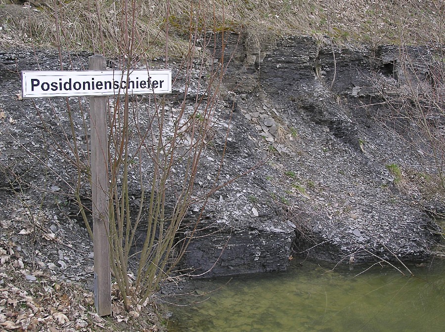
Posidonia Shale
Knowledge base stats:
Talk channels stats:
Members stats:
Posidonia Shale
The Posidonia Shale (German: Posidonienschiefer, also called Schistes Bitumineux in Luxembourg) geologically known as the Sachrang Formation, is an Early Jurassic (Early to Late Toarcian) geological formation in Germany, northern Switzerland, northwestern Austria, southern Luxembourg and the Netherlands, including exceptionally well-preserved complete skeletons of fossil marine fish and reptiles.
The Posidonienschiefer, the German translation, takes its name from the ubiquitous fossils of the oyster-related bivalve "Posidonia bronni" (synonym of Bositra buchii and Steinmannia bronni) that characterize the mollusk faunal component of the formation. The name Posidonia Shale has been used for more than a century, until revisions in 2016 proposed the Sachrang Formation as new name for the Germanic unit, in a same way Altmühltal Formation is the official name of the Solnhofen Limestone. The Posidonia Shales where stablished as a valid vulgar name for this regions lower Toarcian Black Shales. The name Posidonienschiefer, while valid, represents another vulgar nomination, as Posidonia is an invalid genus and junior synonym of Bositra. The type profile is still located on Dotternhausen.
The formation comprises finely laminated layers of oil shales formed of fine-grained sediments intercalated with bituminous limestones and crops out in several locations in southwestern Germany, although most remains are from near the village of Holzmaden and Dotternhausen. The European oil shales deposited on a sea floor during the Early Toarcian in the ancient Tethys Ocean are described as being deposited in an anoxic, or oxygen-depleted, deep water environment, although the details of the depositional environment are the subject of debate by researchers of the formation.
The Posidonia Shale was originally referred to as the Schwarzjura Lias, which was first recovered from the Franconian Jura, which borders to the northeast on the Obermainisches Hügelland and the Oberpfälzisch-Obermainisches Hügelland, tectonically part of the Faulkschollenland. The recovered Franconian Jura rocks lie west of the Saxothuringian basement, bordering the Franconian Line. It is recovered laterally extensive within Germany belonging to the early Toarcian Central European Epicontinental Basin, that evolved gradually from low tophography tidal flat to floodplains to a shallow shelf sea with intermittent N connection with the Viking Corridor and the Proto-Atlantic Ocean and with the Tethys Ocean towards the S, that filled with seawater the area, subdivided in several subasins with heterogeneous conditions and biotas, from the Netherlands to the Tirol Area. The CEB stablished a relatively shallow transcontinental seaway between the Tethyan and Boreal Arctic Sea biota, thus mixing cold and hot waters. The Mesozoic was marked by the breakup of Pangea during the Late Triassic, which led to the appearance of the early Atlantic connecting with the Boreal waters of the Panthalassa Ocean, and several marine to continental subasins locally. The CEB was part of the Laurasian continental-marine shelf that, resting over the Keuper, slowly opened towards the southeast into the deeper Tethys Ocean. With the flooding in the Early Jurassic by marine waters, several islands, submarine sills, and deeper subbasins developed, which contributed to and controlled the evolution of the paleocurrents.
Towards the W is determined by the north–south Kilberg Fault of the Keilberg Rift, the main fault in the Regensburg Basin. Developed by the sinking of the southern German Jura Plateau during the Miocene, it separates the higher, older crystallization of the Moldanubian Basement from the Lower Jurassic chalk complex of the eastern Franconian Jura. During the late Pliensbachian, the zone became a relatively narrow, flat deposit area which flooded during the early Toarcian and reemerged during the Bifrons substage with a changing coastline, thanks to rhythmic uplifts and subsidence of older Paleozoic and Triassic siliciclastic deposits from the east. The granites and gneisses resulting from crystallization were eroded from the Paleozoic exposures on the east, and were deposited on the Jurassic prograded alluvial nearshore sandstone that evolved gradually into the Bajocian layers. The slopes of the area are partially covered by till, soliflucted rubble and loess from the Würm glaciation.
The bituminous facies overlie the Pliensbachian, and are mostly clay marl to marl shales with an organic carbon content of over 2%, with some levels referred to as "bitumen-free" or "bitumen-poor". The lowermost sequence is known as Seegrasschiefer (seagrass slate), appearing just above the limit, being actively burrowed horizons, approximately 15–20 cm thick with clay marl stone appear in the darker, brownish to gray, bituminous clay marl/marl slate. This initial horizons have abundant foraminifera and ostracods as the medium to light gray color without a brown tint. The Formation evolves from bottom to top: blue-gray marls of the uppermost Pliensbachian spinatum zone, being medium gray, pyrite-rich clay marl stones that are still part of the Amaltheenton Formation, which gradually wedge out to the east in the area of Aalen-Wasseralfingen. Towards the middle, they start to include thin, disturbed bituminous horizons found throughout southwest Germany. Gradually, the bioturbation of the seegrasschiefer merges into the subsequent ash-gray marls without a sharp facies boundary. The Aschgrauen Mergel (ash-gray marl) marks the start of the Posidonia Shale, made by dark gray marl, abundant in pyrite with bituminous marl slate intrusions. This horizon marks a sea transgression, as it extends from Asselfingen/Wutach to Aalen-Reichenbach and then wedges out to the east from Aalen-Wasseralfingen. This initial sequence is overlied by extremely thin (2–5 cm), unnamed bituminous, seegrasschiefer clay marl, followed then by a darker layers with the same lithology. The next are the "Koblenzer-Hainzen" clay successions of the upper semicelatum subzone, initially poorly layered and more or less bituminous with abundance of Steirmannia radiata and Dactylioceras semieelatum. This section is marked by pyritized lagerstätten fossils, which are limited to certain areas (Dotternhausen, Holzmaden), and is now well-layered and black-brown in color. The Unteren Schiefern layers (Exaratum) appear next, marked by the highest bitumen content and characterized by very fine light/dark stratification, abundance of pyrite, fine-grained weathering, and the largely absence of bioturbation derived from anoxic conditions, while the accumulation of exceptionally preserved fossils indicates very weak water movement. The next, Untere Stein, is the most important level of the formation, especially in southwest Germany, southern France, and Alsace-Lorraine. It appears across the area either as a concretionary "laibstein" horizon (Aalen region) or as a uniformly layered limestone bank (Wutach area), with Leptolepis coryphaenoides as the character fossil of this limestone bank.
The Mittleren Schiefer/Schieferklotz (upper exaratum to lower elegans subzones) become increasingly poorly layered until it becomes a small brittle limestone bank, the "Stinkkalkbank" (Dotternhausen to Gomaringen and Nürtingen) with Coelodiscus shells, low on bitumen and with biota that marks better oxygenated conditions, such as foraminifera and occasional ostracods. The Obere and Wilder Stein (upper elegans) medium to brown-gray always remain formed as a regular limestone bank of approximately uniform thicknessis, rarely laminated (Dotternhausen) and often shows traces of minor bioturbation (Dotternhausen, Mössingen, Gomaringen; Aalen-Wasseralfingen), becoming calcified towards the upper limit between Nürtingen and Holzmaden, marked with increased presence of Cucullaea muensteri as well foraminifera and ostracods, as well scoria horizons with fish, cephalopod and larger vertebrate remains, as well often contain belemnite rostrums. The last level of the formation is the Wilden Schiefer (probably reaching Bifrons zone) with the presence of "Monotis bank", from Altdorf to Dotternhausen and Göppingen area, with slates getting poorer in bitumen and less layered. The top section is known as "bollensis camp", marked by the mass deposition of Bositra buchi, closed at the top by a new seegrasschiefer. The limit with the Jurensismergel Formation is mostly eroded in profiles, evolving into marlstones. Several outcrops, mostly in the NW (ex. Harz hills), show that relict levels of the Posidonienschiefer lasted until the Upper Toarcian, contemporaneous with the Jurensismergel Fm, known as "Dörntener Schiefer".
The Sachrang Shales were originally cited in the restudy of the Alpine Upper Black Slate, composed of dark gray, somewhat sandy, disintegrating into thin but large plates of Marl that overlies Pliensbachian breccia. The definition of the Sachrang Shales has been convoluted throughout the history of studies at the location, where works on the North Alpine Mesozoic have preferred to call these deposits the Sachranger Shale to give them a brief, different diagnosis. On the Unken Syncline near Lofen, basinal deposits with abundant Aragonite and Calcite helped to know the major Jurassic basin geometry, where on several layers of the same age was complicated due to the posterior Alpine deformation. Correlated Unken and Diessbach basins developed mostly during the Toarcian, with deposition of abundant material from the near Emerged Landmasses. On the Unken Syncline, the breccias associated with the normal faults were deposited until Oxfordian age.
Hub AI
Posidonia Shale AI simulator
(@Posidonia Shale_simulator)
Posidonia Shale
The Posidonia Shale (German: Posidonienschiefer, also called Schistes Bitumineux in Luxembourg) geologically known as the Sachrang Formation, is an Early Jurassic (Early to Late Toarcian) geological formation in Germany, northern Switzerland, northwestern Austria, southern Luxembourg and the Netherlands, including exceptionally well-preserved complete skeletons of fossil marine fish and reptiles.
The Posidonienschiefer, the German translation, takes its name from the ubiquitous fossils of the oyster-related bivalve "Posidonia bronni" (synonym of Bositra buchii and Steinmannia bronni) that characterize the mollusk faunal component of the formation. The name Posidonia Shale has been used for more than a century, until revisions in 2016 proposed the Sachrang Formation as new name for the Germanic unit, in a same way Altmühltal Formation is the official name of the Solnhofen Limestone. The Posidonia Shales where stablished as a valid vulgar name for this regions lower Toarcian Black Shales. The name Posidonienschiefer, while valid, represents another vulgar nomination, as Posidonia is an invalid genus and junior synonym of Bositra. The type profile is still located on Dotternhausen.
The formation comprises finely laminated layers of oil shales formed of fine-grained sediments intercalated with bituminous limestones and crops out in several locations in southwestern Germany, although most remains are from near the village of Holzmaden and Dotternhausen. The European oil shales deposited on a sea floor during the Early Toarcian in the ancient Tethys Ocean are described as being deposited in an anoxic, or oxygen-depleted, deep water environment, although the details of the depositional environment are the subject of debate by researchers of the formation.
The Posidonia Shale was originally referred to as the Schwarzjura Lias, which was first recovered from the Franconian Jura, which borders to the northeast on the Obermainisches Hügelland and the Oberpfälzisch-Obermainisches Hügelland, tectonically part of the Faulkschollenland. The recovered Franconian Jura rocks lie west of the Saxothuringian basement, bordering the Franconian Line. It is recovered laterally extensive within Germany belonging to the early Toarcian Central European Epicontinental Basin, that evolved gradually from low tophography tidal flat to floodplains to a shallow shelf sea with intermittent N connection with the Viking Corridor and the Proto-Atlantic Ocean and with the Tethys Ocean towards the S, that filled with seawater the area, subdivided in several subasins with heterogeneous conditions and biotas, from the Netherlands to the Tirol Area. The CEB stablished a relatively shallow transcontinental seaway between the Tethyan and Boreal Arctic Sea biota, thus mixing cold and hot waters. The Mesozoic was marked by the breakup of Pangea during the Late Triassic, which led to the appearance of the early Atlantic connecting with the Boreal waters of the Panthalassa Ocean, and several marine to continental subasins locally. The CEB was part of the Laurasian continental-marine shelf that, resting over the Keuper, slowly opened towards the southeast into the deeper Tethys Ocean. With the flooding in the Early Jurassic by marine waters, several islands, submarine sills, and deeper subbasins developed, which contributed to and controlled the evolution of the paleocurrents.
Towards the W is determined by the north–south Kilberg Fault of the Keilberg Rift, the main fault in the Regensburg Basin. Developed by the sinking of the southern German Jura Plateau during the Miocene, it separates the higher, older crystallization of the Moldanubian Basement from the Lower Jurassic chalk complex of the eastern Franconian Jura. During the late Pliensbachian, the zone became a relatively narrow, flat deposit area which flooded during the early Toarcian and reemerged during the Bifrons substage with a changing coastline, thanks to rhythmic uplifts and subsidence of older Paleozoic and Triassic siliciclastic deposits from the east. The granites and gneisses resulting from crystallization were eroded from the Paleozoic exposures on the east, and were deposited on the Jurassic prograded alluvial nearshore sandstone that evolved gradually into the Bajocian layers. The slopes of the area are partially covered by till, soliflucted rubble and loess from the Würm glaciation.
The bituminous facies overlie the Pliensbachian, and are mostly clay marl to marl shales with an organic carbon content of over 2%, with some levels referred to as "bitumen-free" or "bitumen-poor". The lowermost sequence is known as Seegrasschiefer (seagrass slate), appearing just above the limit, being actively burrowed horizons, approximately 15–20 cm thick with clay marl stone appear in the darker, brownish to gray, bituminous clay marl/marl slate. This initial horizons have abundant foraminifera and ostracods as the medium to light gray color without a brown tint. The Formation evolves from bottom to top: blue-gray marls of the uppermost Pliensbachian spinatum zone, being medium gray, pyrite-rich clay marl stones that are still part of the Amaltheenton Formation, which gradually wedge out to the east in the area of Aalen-Wasseralfingen. Towards the middle, they start to include thin, disturbed bituminous horizons found throughout southwest Germany. Gradually, the bioturbation of the seegrasschiefer merges into the subsequent ash-gray marls without a sharp facies boundary. The Aschgrauen Mergel (ash-gray marl) marks the start of the Posidonia Shale, made by dark gray marl, abundant in pyrite with bituminous marl slate intrusions. This horizon marks a sea transgression, as it extends from Asselfingen/Wutach to Aalen-Reichenbach and then wedges out to the east from Aalen-Wasseralfingen. This initial sequence is overlied by extremely thin (2–5 cm), unnamed bituminous, seegrasschiefer clay marl, followed then by a darker layers with the same lithology. The next are the "Koblenzer-Hainzen" clay successions of the upper semicelatum subzone, initially poorly layered and more or less bituminous with abundance of Steirmannia radiata and Dactylioceras semieelatum. This section is marked by pyritized lagerstätten fossils, which are limited to certain areas (Dotternhausen, Holzmaden), and is now well-layered and black-brown in color. The Unteren Schiefern layers (Exaratum) appear next, marked by the highest bitumen content and characterized by very fine light/dark stratification, abundance of pyrite, fine-grained weathering, and the largely absence of bioturbation derived from anoxic conditions, while the accumulation of exceptionally preserved fossils indicates very weak water movement. The next, Untere Stein, is the most important level of the formation, especially in southwest Germany, southern France, and Alsace-Lorraine. It appears across the area either as a concretionary "laibstein" horizon (Aalen region) or as a uniformly layered limestone bank (Wutach area), with Leptolepis coryphaenoides as the character fossil of this limestone bank.
The Mittleren Schiefer/Schieferklotz (upper exaratum to lower elegans subzones) become increasingly poorly layered until it becomes a small brittle limestone bank, the "Stinkkalkbank" (Dotternhausen to Gomaringen and Nürtingen) with Coelodiscus shells, low on bitumen and with biota that marks better oxygenated conditions, such as foraminifera and occasional ostracods. The Obere and Wilder Stein (upper elegans) medium to brown-gray always remain formed as a regular limestone bank of approximately uniform thicknessis, rarely laminated (Dotternhausen) and often shows traces of minor bioturbation (Dotternhausen, Mössingen, Gomaringen; Aalen-Wasseralfingen), becoming calcified towards the upper limit between Nürtingen and Holzmaden, marked with increased presence of Cucullaea muensteri as well foraminifera and ostracods, as well scoria horizons with fish, cephalopod and larger vertebrate remains, as well often contain belemnite rostrums. The last level of the formation is the Wilden Schiefer (probably reaching Bifrons zone) with the presence of "Monotis bank", from Altdorf to Dotternhausen and Göppingen area, with slates getting poorer in bitumen and less layered. The top section is known as "bollensis camp", marked by the mass deposition of Bositra buchi, closed at the top by a new seegrasschiefer. The limit with the Jurensismergel Formation is mostly eroded in profiles, evolving into marlstones. Several outcrops, mostly in the NW (ex. Harz hills), show that relict levels of the Posidonienschiefer lasted until the Upper Toarcian, contemporaneous with the Jurensismergel Fm, known as "Dörntener Schiefer".
The Sachrang Shales were originally cited in the restudy of the Alpine Upper Black Slate, composed of dark gray, somewhat sandy, disintegrating into thin but large plates of Marl that overlies Pliensbachian breccia. The definition of the Sachrang Shales has been convoluted throughout the history of studies at the location, where works on the North Alpine Mesozoic have preferred to call these deposits the Sachranger Shale to give them a brief, different diagnosis. On the Unken Syncline near Lofen, basinal deposits with abundant Aragonite and Calcite helped to know the major Jurassic basin geometry, where on several layers of the same age was complicated due to the posterior Alpine deformation. Correlated Unken and Diessbach basins developed mostly during the Toarcian, with deposition of abundant material from the near Emerged Landmasses. On the Unken Syncline, the breccias associated with the normal faults were deposited until Oxfordian age.
Recent media