Hubbry Logo
PykaraPykaraMain
Open search
Pykara
Community hub
Pykara
logo
8 pages, 0 posts
0 subscribers
Be the first to start a discussion here.
Pykara
Pykara
from Wikipedia

The Pykara is a river 19 kilometres (12 mi) from Ooty in the Indian State of Tamil Nadu with a village by the same name nearby.[1] The Pykara River is considered very sacred by the Todas.[2] It rises at Mukurthi peak, flows northwards, and then turns to the west after reaching the edge of the plateau.[2] The river flows through Mukurthi, Pykara and Glenmorgan dams, and forms part of an important hydro-electric power project. It is a tributary of the Moyar river, which in turn is a tributary of the Bhavani river, which itself is a tributary of the Kaveri river.

Key Information

The river flows over a series of waterfalls, the last two of 55 metres (180 ft) and 61 metres (200 ft) being known as Pykara Falls.[2] The falls are approximately 6 kilometres (4 mi) from the bridge on the main road. There is a forest rest house at Pykara. A boat house on the Pykara reservoir is an added attraction for tourists. Pykara has well-protected, fenced sholas, Toda settlements, large grassy meadows and good wildlife habitat. The Pykara Dam, falls and reservoir attract many tourists.[1]

Climate

[edit]

Pykara's climate is classified as subtropical highland climate (Cwb) under the Köppen climate classification. Pykara, due to its location in the Nilgiris, gets rain from both the monsoons. The wet season runs from April to December and the dry season from January to March.

Climate data for Pykara
Month Jan Feb Mar Apr May Jun Jul Aug Sep Oct Nov Dec Year
Mean daily maximum °C (°F) 19.7
(67.5)
19.9
(67.8)
22.4
(72.3)
22.5
(72.5)
22.7
(72.9)
19.2
(66.6)
17.4
(63.3)
18.5
(65.3)
19.4
(66.9)
19.4
(66.9)
19.1
(66.4)
19.0
(66.2)
19.9
(67.9)
Mean daily minimum °C (°F) 6.7
(44.1)
7.7
(45.9)
9.8
(49.6)
11.6
(52.9)
12.4
(54.3)
12.5
(54.5)
12.3
(54.1)
12.3
(54.1)
12.0
(53.6)
11.5
(52.7)
9.7
(49.5)
7.5
(45.5)
10.5
(50.9)
Average precipitation mm (inches) 19.5
(0.77)
18.3
(0.72)
32.2
(1.27)
104.4
(4.11)
165.5
(6.52)
250.2
(9.85)
475.1
(18.70)
313.3
(12.33)
175.6
(6.91)
244.7
(9.63)
148.2
(5.83)
76.3
(3.00)
2,023.3
(79.64)
Average rainy days 3 2 4 8 11 12 17 18 11 13 12 8 119
Source: Climate-Data.org[3]

Dam and power station

[edit]
Pykara Falls in 1913
Tourists in a speed boat on Pykara Lake, view from the Boat House

The dam is near the main Ooty–Gudalur road and includes a power station. One of the oldest power plants in South India, the Pykara station still functions, generating about 60 megawatts. The first unit of 6.65 MW was commissioned in October 1932.[4] Sir C.P. Ramaswamy Aiyar, Diwan of Travancore, worked with the British regime in 1920s and 1930s in the setting up of the Pykara project. A team of engineers led by H.G. Howard, a chief engineer in the then electricity department, was responsible for carrying out the project.[4] The Bangalore-Chennai industrial region is highly dependent on the Pykara hydroelectric plant.

The Pykara Station, declared as a heritage plant in September 1997, triggered the establishment of more hydro-electric power stations in the state. Today, the Nilgiris district alone boasts hydro-electric stations with an aggregate installed capacity of 837 MW. Five decades after establishment of the old plant, the Electricity Board (EB) authorities came up with a plan for the Pykara Ultimate Stage Hydro Electric Plant (PUSHEP), containing three units of 50 MW each. The construction of an underground powerhouse, 17 tunnels and the hydraulic head of 1,039 metres (3,409 ft) are the special features of the new plant. According to the EB, the hydraulic head is the highest in Asia. The access to the powerhouse is a tunnel 1.5 kilometres (0.9 mi) long.[4]
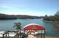
Boat house

[edit]

A boat house on the Pykara Reservoir is an added attraction for tourists. The boat house with restaurant is maintained by the Tamil Nadu Tourism Development Corporation. It has several motor boats which are allowed for 20 minutes and speed boats which are allowed for 10 minutes (as of 2011).[1]

[edit]

References

[edit]

External sources

[edit]

11°27′17″N 76°35′50″E / 11.4547°N 76.5972°E / 11.4547; 76.5972

Revisions and contributorsEdit on WikipediaRead on Wikipedia
from Grokipedia
Pykara is a prominent river and scenic area in the of , , renowned for its cascading waterfalls, lake, and lush surroundings that form a major tourist attraction approximately 20 km from . As the largest river in the , Pykara originates at Mukurthi Peak and flows northward before turning westward, holding sacred significance for the indigenous Toda community. The river features a series of cascades, culminating in the dramatic Pykara Falls, which drop 55 meters and 61 meters in two notable segments, best viewed during the monsoon season when water flow is at its peak. Adjacent to the falls is Pykara Lake, a serene created by the Pykara Dam at an elevation of about 2,047 meters, surrounded by verdant hills, tea plantations, and dense forests that support diverse and , including birds and fish. The area encompasses additional attractions like the expansive grassy meadows of Wenlock Downs, ideal for picnics and often used as a filming location, and the nearby Glenmorgan village, which includes an early 20th-century tea estate and the forebay for the Pykara hydroelectric powerhouse. Popular activities include on the lake (with pedal and rowboat options available for a fee), trekking along forested trails, , and , making Pykara a favored destination for nature enthusiasts and honeymooners. The site is accessible year-round but reveals its full splendor in the and winter months, with facilities like a enhancing visitor experience; entry to the lake area costs Rs. 10 per person, and it operates from 8:30 AM to 5:30 PM.

Geography

Location and topography

Pykara is situated in the of , , at coordinates 11°27′17″N 76°35′50″E. It lies approximately 20 kilometers north of along the Ooty-Mysore road (NH181), serving as a key point in the region's connectivity. As part of the within the , Pykara occupies a high-elevation landscape characterized by undulating plateaus, expansive grasslands, and patches of forests. Elevations in the area range from about 2,000 to 2,300 meters above sea level, with an average around 2,100 meters, creating a rugged terrain that supports unique ecological niches. The surrounding topography includes steep escarpments and rolling hills that contribute to the Nilgiris' status as a . Geologically, Pykara and the broader Nilgiris form part of an ancient landmass, uplifted as part of the , dominated by metamorphic rocks such as charnockites and gneisses rather than volcanic formations. This crystalline foundation, dating back over 2,500 million years, underlies the area's stable yet elevated structure, influencing and vegetation patterns. The Pykara River originates near Mukurthi Peak in this terrain, adding to the hydrological features without altering the static landforms.

River and hydrology

The Pykara River originates at Mukurthi Peak in the Nilgiri Hills of , , at an elevation of 2,554 meters. It flows northward through rugged hilly terrain for approximately 19 kilometers before turning westward upon reaching the edge of the Nilgiri plateau. Along its course, the river descends dramatically in a series of cascades, culminating in the Pykara Falls, which feature two prominent drops measuring 55 meters and 61 meters. As a key component of the regional water system, the Pykara serves as a to the , which in turn feeds into the and ultimately the larger River basin. The river's hydrology is dominated by seasonal variations, with the bulk of its annual flow driven by the southwest rains that replenish the Nilgiris' highland streams from to . This monsoon-influenced discharge supports downstream needs in the arid plains and contributes to hydroelectric generation in the Nilgiri region, though specific discharge volumes vary annually based on rainfall patterns averaging around 1,930 millimeters in the district. The Pykara is distinguished by its exceptionally clear waters, which foam white as they rush over rocky beds.

History

Etymology and indigenous significance

The name "Pykara" originates from the indigenous Toda language, where the river system is known as Kawllykeen, referring to the stream flowing from Mukurthi Peak through the Nilgiris. This term highlights the river's identity as a vital in the Toda landscape. To the Toda people, the Kawllykeen (Pykara) holds profound spiritual significance as their most sacred river, embodying the deity Awllvoy, whose presence is believed to infuse its waters with divine essence. The river features prominently in Toda rituals, such as annual ceremonies conducted atop Paw(r)sh Hill to invoke blessings for its health and the surrounding , ensuring the prosperity of their way of life. It also supports sacred buffalo herding, a cornerstone of Toda culture, where buffaloes are revered as embodiments of wealth and ritual purity, grazing along its banks and contributing to dairy-temple practices tied to the river's flow. Historically, the Pykara delineates boundaries for Toda sacred lands, marking territories integral to their ancestral domains and spiritual geography in the Nilgiris. As part of the Toda sacred hills ecosystem, it underscores the cultural heritage recognized within the UNESCO-designated , emphasizing the interconnectedness of indigenous knowledge and biodiversity conservation.

Colonial development

British surveys in the early 19th century played a pivotal role in identifying the Nilgiris, including the Pykara region, as a potential for colonial retreats. In 1819, John Sullivan, the Collector of , led an expedition to explore the plateau, mapping its topography and recognizing its temperate climate as suitable for European settlement amid the heat of the plains. This initial reconnaissance, authorized by the , laid the groundwork for administrative control and development, transforming the remote hills into an accessible colonial enclave. The Pykara area saw significant development in the 1920s and 1930s, driven by the need for hydroelectric power to support the industrializing Madras Presidency. Sir C.P. Ramaswamy Aiyar, as a key advisor and later Advocate-General, collaborated with British authorities to champion the Pykara hydroelectric scheme, overcoming political and technical opposition to initiate planning and procurement of machinery by 1926. This effort included the establishment of forest rest houses for oversight and the extension of initial road access to facilitate construction, enabling connectivity to the broader Nilgiris network by around 1930. The project culminated in the dam's commissioning in 1932, marking a milestone in regional energy infrastructure. These colonial initiatives profoundly impacted the local landscape, introducing tea plantations that reshaped the Nilgiris' economy and ecology. Starting in the , British planters established commercial tea estates across the hills, drawing on the region's and to cultivate , which by the late dominated the terrain around Pykara and beyond. European-style also emerged, with bungalows and retreats built to attract officials seeking respite, fostering a sanitized, picturesque aesthetic that prioritized scenic vistas over indigenous uses. While these changes cleared forests for and access, some Toda communal lands were demarcated and preserved under colonial surveys, mitigating total displacement.

Climate and biodiversity

Climate

Pykara features a subtropical highland climate (Cwb) under the Köppen-Geiger classification, characterized by mild temperatures and significant seasonal influenced by its high in the Nilgiri hills. The annual average high temperature is approximately 24°C, with an average low of 8°C, reflecting the moderating effects of altitude. Temperatures are coolest in , when minimums can drop to around 8°C, and warmest in May, with maximums reaching up to 24°C. Precipitation averages about 1,920 mm annually in the broader encompassing Pykara, with the wet season spanning April to December and driven by southwest monsoon rains enhanced by from the . The dry season occurs from January to March, though fog and mist are common year-round due to the region's above 2,000 meters, contributing to high levels. This climatic regime supports diverse ecosystems, influencing local flora and fauna as detailed in the Flora and fauna section.

Flora and fauna

The Pykara region, nestled within the in the , supports a diverse array of and adapted to its montane ecosystems. As part of this UNESCO-designated biosphere, the area features forests and grasslands that harbor endemic species, contributing to the high of the Nilgiris. These habitats are integral to the reserve's role in conserving the ' ecological richness. The flora of Pykara is dominated by forests, which are montane woodlands characterized by stunted trees with dense canopies, typically found above 1,800 meters elevation. These forests include such as Rhododendron nilagiricum and Michelia nilagirica, which thrive in the misty, high-altitude conditions and play a key role in water retention and . Interspersed with the sholas are expansive grasslands that support unique herbaceous and provide foraging grounds for herbivores. The broader Nilgiris region, encompassing Pykara, boasts over 3,300 of flowering , with 132 endemic to the , highlighting the area's status as a global biodiversity hotspot. Faunal diversity in Pykara includes several endangered mammals that utilize the shola-grassland mosaic for habitat. Notable species are the (Elephas maximus), (Panthera tigris), (Nilgiritragus hylocrius), and (Semnopithecus johnii), all of which are adapted to the region's varied terrain and face habitat pressures. Avian life is equally rich, with endemic birds such as the Nilgiri flycatcher (Eumyias albicaudatus) inhabiting the forested areas. The Pykara River sustains freshwater ecosystems, supporting endemic fish species like those in the genera Horabagrus and Bhavania, as well as amphibians that depend on the riparian zones for breeding. Overall, the records over 100 species, 350 birds, and 80 reptiles and amphibians, many of which occur in the Pykara vicinity. Conservation efforts in the Pykara area are bolstered by its inclusion in the World Heritage-listed , which emphasizes protection of its endemic . Nearby protected areas, such as Mukurthi National Park, safeguard critical habitats for species like the . However, threats from tourism-related development and , including altered rainfall patterns and , pose risks to these ecosystems, necessitating ongoing monitoring and community-based management.

Infrastructure

Dam and power station

The Pykara Dam is situated on the -Gudalur road, approximately 12 km from in the of , , impounding the waters of the Pykara River for hydroelectric power generation and irrigation purposes. Constructed as an earthen dam during the British colonial era, it forms a that supports regional water management needs. The dam's engineering design emphasizes stability in the hilly terrain, utilizing compacted earth materials to create an effective barrier for water storage. The associated Pykara Hydro Electric Power Station, commissioned in 1932, represents one of South India's earliest hydroelectric facilities, with an original installed capacity of 70 MW across multiple units, including initial turbines added in . This run-of-river project harnesses the river's flow to generate electricity, contributing an annual output of around 161.5 GWh to the power grid. In 2005, the Pykara Ultimate Stage Hydro Electric Plant (PUSHEP) was added, boosting capacity by 150 MW through three 50 MW units operating under a gross head of 1,039 meters—the highest in —enhancing overall efficiency and output for the state's energy demands. Recognized for its , the original was declared a heritage plant in 1997 by the government, preserving its colonial-era infrastructure while allowing continued operations. Subsequent renovation and modernization efforts, overseen by the Tamil Nadu Generation and Distribution Corporation (TANGEDCO), have focused on improving efficiency, upgrading control systems, and ensuring environmental compliance to sustain reliable power production amid varying hydrological conditions. These enhancements have optimized the facility's performance without altering its core heritage status.

Boat house

The Boat House at Pykara is situated on the Pykara Reservoir in the of , , providing a dedicated docking facility for various types of boats amid the region's lush pine forests and rolling hills. Managed by the (TTDC), it functions as a central hub for recreational boating, equipped with modern amenities to support visitor experiences on the water. The reservoir hosting the Boat House was formed by the Pykara Dam, built in the early as part of early hydroelectric initiatives in the area. Key activities include motor rides lasting about 20 minutes for groups of 8 to 10 passengers and speed rides of roughly 10 minutes for 2 to 4 passengers, allowing to navigate the reservoir's serene expanse. Recent additions feature water scooter rides, offering high-speed options for adventure seekers. fees are charged per vessel; representative costs as of 2025 include ₹770 plus tax for an 8-seater motor and ₹1,150 for a 10-minute speed ride. Safety protocols are prioritized, with mandatory life jackets for all passengers, trained operators, and on-site rescue equipment to ensure secure operations. Development of the Boat House began after the dam's completion in the 1930s, evolving from basic facilities to a structured site under TTDC oversight. In the , enhancements have emphasized eco-tourism, such as the 2024 introduction of a ₹4.5 speedboat and water scooters to boost sustainable visitor engagement while minimizing environmental impact.

Tourism

Key attractions

Pykara Falls feature twin cascades plunging 55 meters and 61 meters, respectively, forming a dramatic highlight amid the Nilgiri hills. These falls, created by the Pykara River originating from Mukurthi Peak, descend in a series of tiers over rocky beds, offering a mesmerizing display of water against lush backdrops. Located about 20 kilometers from Ooty along the Ooty-Mysore road, the site is enveloped by dense shola forests, making it an ideal spot for photography, especially post-monsoon when the flows are at their peak. Adjacent to the falls lies Pykara Lake, a serene impounded by the Pykara Dam, renowned for its mirror-like reflections of surrounding emerald hills and azure skies. Fringed by forests, woodlands, and expansive grassy meadows, the lake provides stunning panoramic views and tranquil settings perfect for picnics and leisurely nature walks. The crisp mountain air, infused with pine scents and the murmur of the river, enhances the area's peaceful ambiance. Beyond these core sites, Pykara encompasses nearby Toda settlements, where the indigenous Toda community maintains traditional pastoral lifestyles, and accessible trails that invite short hikes through well-protected forested paths. These elements contribute to the region's rich cultural and ecological tapestry, with the surrounding areas supporting diverse flora and fauna typical of the Nilgiris .

Visitor information

Pykara is accessible approximately 20 km from along the Ooty-Mysore Road (NH181), making it a convenient destination. Visitors can reach the site via public buses departing from Ooty , taxis, or private vehicles, with the journey taking about 45 minutes to 1 hour depending on traffic. From the main parking area near Pykara Lake, the Pykara Falls viewpoint requires a moderate 1.5-2 km trek through forested paths, which typically takes 30-60 minutes and involves some elevation gain of around 200 feet; comfortable footwear is recommended for this hike. As of November 2025, Pykara Falls is temporarily closed until further notice per Forest Department instructions; check current status before visiting. The optimal time to visit Pykara is from October to March, when the weather is mild and post-monsoon conditions enhance the waterfalls' flow without the risks of heavy rains. During this period, daytime temperatures range from 10-20°C, ideal for outdoor activities. Monsoon season (June-September) should be avoided due to unpredictable water levels and potential landslides. Entry fees are nominal: ₹40 per person (as of 2025) for access to the lake and falls areas, with additional parking charges of ₹10 for two-wheelers and ₹20-40 for cars. Boating at Pykara Lake incurs higher costs, such as ₹770 + tax for a 20-minute motorboat ride accommodating up to 8 people (as of 2025), while speed boats start at ₹780 for 10 minutes. Trekking to the falls does not require special permits, but visitors should check for any seasonal restrictions at the entry point. Facilities at Pykara include rest house for overnight stays, bookable through forest department channels, offering basic accommodations amid the natural surroundings. A near the boat house provides meals, and life jackets are mandatory for all boating activities to ensure safety. Safety considerations are crucial near the falls, where paths can become slippery, especially after rain; swimming is strongly discouraged due to sharp rocks and strong currents at the lower cascades. Visitors are advised to stay on marked trails and avoid venturing too close to the water's edge. To promote , eco-guidelines emphasize minimizing plastic use, adhering to waste disposal rules, and respecting the local by not disturbing or . These measures aim to preserve the area's pristine ecosystem while supporting responsible practices.

References

Add your contribution
Related Hubs
User Avatar
No comments yet.