Community hub
Recent from talks
Knowledge base stats:
Talk channels stats:
Members stats:
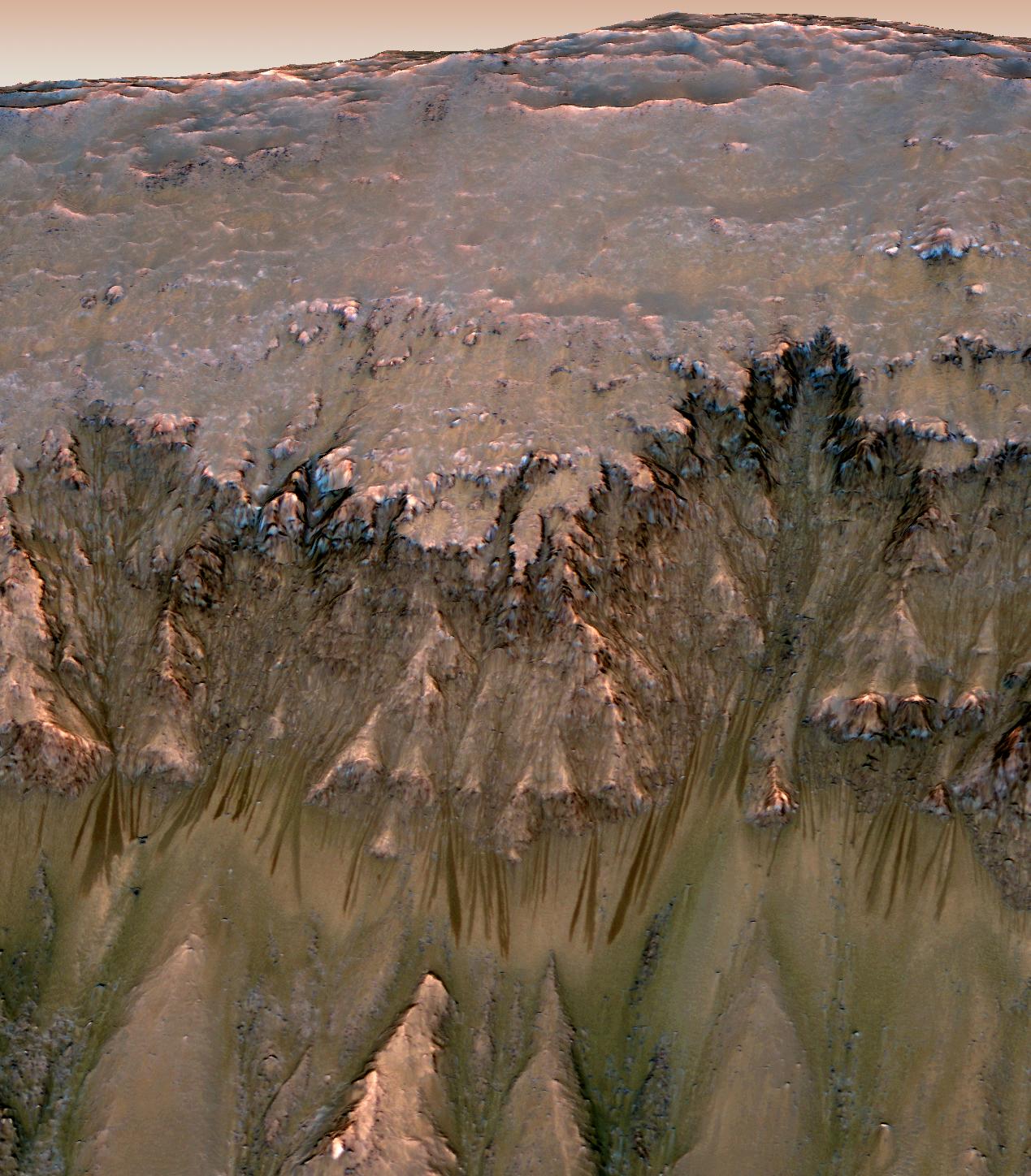
Seasonal flows on warm Martian slopes
Seasonal flows on warm Martian slopes (also called recurring slope lineae, recurrent slope lineae and RSL) are thought to be either salty water flows occurring during the warmest months on Mars, or dry grains that "flow" downslope of at least 27 degrees.
The flows are narrow (0.5 to 5 meters) and exhibit relatively dark markings on steep (25° to 40°) slopes, appear and incrementally grow during warm seasons and fade in cold seasons. Liquid brines near the surface have been proposed to explain this activity, or interactions between sulfates and chlorine salts that interact under to produce landslides.
Research indicates that in the past there was liquid water flowing on the surface of Mars, creating large areas similar to Earth's oceans. However, the question remains as to where the water has gone.
The Mars Reconnaissance Orbiter (MRO) is a multipurpose spacecraft launched in 2005 designed to conduct reconnaissance and exploration of Mars from orbit. The spacecraft is managed by the Jet Propulsion Laboratory (JPL). The HiRISE camera onboard the MRO is at the forefront of the ongoing RSL studies as it helps chart the features with images of closely monitored sites typically taken every few weeks. The 2001 Mars Odyssey orbiter has been using spectrometers and a thermal imager for over 16 years to detect evidence of past or present water and ice. It has detected none at the RSL. On October 5, 2015, possible RSL were reported on Mount Sharp near the Curiosity rover.
Distinctive properties of recurring slope lineae (RSL) include slow incremental growth, formation on warm slopes in warm seasons, and annual fading and recurrence, showing a strong correlation with solar heating. RSL extend down slope from bedrock outcrops often following small gullies about 0.5 to 5 meters (1 ft 8 in to 16 ft 5 in) wide, with lengths up to hundreds of meters, and some of the locations display more than 1,000 individual flows. RSL advance rates are highest at the beginning of each season, followed by much slower lengthening. RSL appear and lengthen in the late southern spring and summer from 48°S to 32°S latitudes that favor equator-facing slopes, which are times and places with peak surface temperatures from −23 °C to 27 °C. Active RSL also occur in equatorial regions (0–15°S), most commonly in the Valles Marineris troughs.
Researchers surveyed flow-marked slopes with the Mars Reconnaissance Orbiter's CRISM and although there is no spectrographic evidence for actual water, the instrument has directly imaged perchlorate salts thought to be dissolved in water brines in the subsurface. This may indicate the water quickly evaporates upon reaching the surface, leaving only the salts. The cause of the surface darkening and lightening is poorly understood: a flow initiated by salty water (brine) could rearrange grains or change surface roughness in a way that darkens the appearance, but the way the features brighten again when temperatures drop is harder to explain. However, in November 2018, it was announced that CRISM had fabricated some additional pixels representing the minerals alunite, kieserite, serpentine and perchlorate. The instrument team found that some false positives were caused by a filtering step when the detector switches from a high luminosity area to shadows. Reportedly, 0.05% of the pixels were indicating perchlorate, now known to be a false high estimate by this instrument. Reduced content of salts on the slopes reduces the chances of the presence of brines.
A number of different hypotheses for RSL formation have been proposed. The seasonality, latitude distribution, and brightness changes strongly indicate a volatile material—such as water or liquid CO
2—is involved. One hypothesis is that RSL could form by rapid heating of nocturnal frost in agreement with experimental results. Another one proposes flows of carbon dioxide, but the settings in which the flows occur are too warm for carbon-dioxide frost (CO
2), and at some sites is too cold for pure water. Other hypotheses include dry granular flows, but no entirely dry process can explain seasonal flows that progressively grow over weeks and months. Cornice avalanches is another hypothesis. The idea is that wind collects snow or frost just past the peak of a mountain and then this becomes an avalanche after it warms up. Seasonal melting of shallow ice would explain the RSL observations, but it would be difficult to replenish such ice annually. However, as of 2015, direct observations of seasonal deposition of soluble salts strongly suggest that RSL involve brine (hydrated salts).
The leading hypothesis involves the flow of brines (very salty water). Salt deposits over much of Mars indicate that brine was abundant in Mars's past. Salinity lowers the freezing point of water to sustain a liquid flow. Less saline water would freeze at the observed temperatures. Thermal infrared data from the Thermal Emission Imaging System (THEMIS) on board the 2001 Mars Odyssey orbiter, have allowed the temperature conditions under which RSL form to be constrained. While a small number of RSL are visible at temperatures above the freezing point of water, most are not, and many appear at temperatures as low as −43 °C (230 K). Some scientists think that under these cold conditions, a brine of iron(III) sulfate (Fe2(SO4)3) or calcium chloride (CaCl
2) is the most likely mode of RSL formation. Another team of scientists, using the CRISM instrument onboard MRO, reported that the evidence for hydrated salts is most consistent with the spectral absorption features of magnesium perchlorate (Mg(ClO4)2), magnesium chloride (MgCl2(H2O)x) and sodium perchlorate (NaClO
4).
Hub AI
Seasonal flows on warm Martian slopes AI simulator
(@Seasonal flows on warm Martian slopes_simulator)
Seasonal flows on warm Martian slopes
Seasonal flows on warm Martian slopes (also called recurring slope lineae, recurrent slope lineae and RSL) are thought to be either salty water flows occurring during the warmest months on Mars, or dry grains that "flow" downslope of at least 27 degrees.
The flows are narrow (0.5 to 5 meters) and exhibit relatively dark markings on steep (25° to 40°) slopes, appear and incrementally grow during warm seasons and fade in cold seasons. Liquid brines near the surface have been proposed to explain this activity, or interactions between sulfates and chlorine salts that interact under to produce landslides.
Research indicates that in the past there was liquid water flowing on the surface of Mars, creating large areas similar to Earth's oceans. However, the question remains as to where the water has gone.
The Mars Reconnaissance Orbiter (MRO) is a multipurpose spacecraft launched in 2005 designed to conduct reconnaissance and exploration of Mars from orbit. The spacecraft is managed by the Jet Propulsion Laboratory (JPL). The HiRISE camera onboard the MRO is at the forefront of the ongoing RSL studies as it helps chart the features with images of closely monitored sites typically taken every few weeks. The 2001 Mars Odyssey orbiter has been using spectrometers and a thermal imager for over 16 years to detect evidence of past or present water and ice. It has detected none at the RSL. On October 5, 2015, possible RSL were reported on Mount Sharp near the Curiosity rover.
Distinctive properties of recurring slope lineae (RSL) include slow incremental growth, formation on warm slopes in warm seasons, and annual fading and recurrence, showing a strong correlation with solar heating. RSL extend down slope from bedrock outcrops often following small gullies about 0.5 to 5 meters (1 ft 8 in to 16 ft 5 in) wide, with lengths up to hundreds of meters, and some of the locations display more than 1,000 individual flows. RSL advance rates are highest at the beginning of each season, followed by much slower lengthening. RSL appear and lengthen in the late southern spring and summer from 48°S to 32°S latitudes that favor equator-facing slopes, which are times and places with peak surface temperatures from −23 °C to 27 °C. Active RSL also occur in equatorial regions (0–15°S), most commonly in the Valles Marineris troughs.
Researchers surveyed flow-marked slopes with the Mars Reconnaissance Orbiter's CRISM and although there is no spectrographic evidence for actual water, the instrument has directly imaged perchlorate salts thought to be dissolved in water brines in the subsurface. This may indicate the water quickly evaporates upon reaching the surface, leaving only the salts. The cause of the surface darkening and lightening is poorly understood: a flow initiated by salty water (brine) could rearrange grains or change surface roughness in a way that darkens the appearance, but the way the features brighten again when temperatures drop is harder to explain. However, in November 2018, it was announced that CRISM had fabricated some additional pixels representing the minerals alunite, kieserite, serpentine and perchlorate. The instrument team found that some false positives were caused by a filtering step when the detector switches from a high luminosity area to shadows. Reportedly, 0.05% of the pixels were indicating perchlorate, now known to be a false high estimate by this instrument. Reduced content of salts on the slopes reduces the chances of the presence of brines.
A number of different hypotheses for RSL formation have been proposed. The seasonality, latitude distribution, and brightness changes strongly indicate a volatile material—such as water or liquid CO
2—is involved. One hypothesis is that RSL could form by rapid heating of nocturnal frost in agreement with experimental results. Another one proposes flows of carbon dioxide, but the settings in which the flows occur are too warm for carbon-dioxide frost (CO
2), and at some sites is too cold for pure water. Other hypotheses include dry granular flows, but no entirely dry process can explain seasonal flows that progressively grow over weeks and months. Cornice avalanches is another hypothesis. The idea is that wind collects snow or frost just past the peak of a mountain and then this becomes an avalanche after it warms up. Seasonal melting of shallow ice would explain the RSL observations, but it would be difficult to replenish such ice annually. However, as of 2015, direct observations of seasonal deposition of soluble salts strongly suggest that RSL involve brine (hydrated salts).
The leading hypothesis involves the flow of brines (very salty water). Salt deposits over much of Mars indicate that brine was abundant in Mars's past. Salinity lowers the freezing point of water to sustain a liquid flow. Less saline water would freeze at the observed temperatures. Thermal infrared data from the Thermal Emission Imaging System (THEMIS) on board the 2001 Mars Odyssey orbiter, have allowed the temperature conditions under which RSL form to be constrained. While a small number of RSL are visible at temperatures above the freezing point of water, most are not, and many appear at temperatures as low as −43 °C (230 K). Some scientists think that under these cold conditions, a brine of iron(III) sulfate (Fe2(SO4)3) or calcium chloride (CaCl
2) is the most likely mode of RSL formation. Another team of scientists, using the CRISM instrument onboard MRO, reported that the evidence for hydrated salts is most consistent with the spectral absorption features of magnesium perchlorate (Mg(ClO4)2), magnesium chloride (MgCl2(H2O)x) and sodium perchlorate (NaClO
4).