.jpg/250px-Georgian_Laz_people_monument_in_Rize_(Modern_Day_Turkey).jpg "Rize")
Rize (Turkish pronunciation: [ɾi'ze]; Greek: Ριζούντα, romanized: Rizoúnta; Laz: რიზინი, romanized: Rizini; Georgian: რიზე) is a coastal city in the eastern part of the Black Sea Region of Turkey. It is the seat of Rize Province and Rize District.[2] Its population is 119,828 (2021).[1] Rize is a typical Turkish provincial capital with little in the way of nightlife or entertainment.[citation needed] Since the border with Georgia was opened in the early 1990s, the Black Sea coast road has been widened and the town is much wealthier than it used to be. Current Turkish President Recep Tayyip Erdoğan's family has its roots in Rize and the local university is named after him. The city is linked by road with Trabzon (41 miles [66 km] west), Hopa (55 miles [88 km] east on the Georgian border, and Erzurum (south). The Rize–Artvin Airport started operating in 2022.
Key Information

.jpg)


Name
[edit]The name comes from Greek ρίζα (riza) or Ριζαίον (Rizaion)[citation needed], meaning "mountain slopes" (ρίζα in Greek means root).[3] In modern times, its Greek name was usually Ριζούντα (Rizunda). Its Latin forms are Rhizus and Rhizaeum, the latter of which is used in the Catholic Church's list of titular sees as the name of bishopric of the town, which was once part of the late Roman province of Pontus Polemoniacus[4]).
Other names (17th – 19th c.): Rizeh, Riseh, Rhizium, Irizeh, Irissa; used in trade or by merchants.[5][6][7][8][9]
History
[edit]Arrian was the first writer to mention Rize. In his Periplus of the Euxine Sea,[10] he described it as a city founded at the mouth of the river of the same name, the ancient and Byzantine ῾Ρίζιος ποταμός.[11] Dated to 130–131AD and written as a letter to Roman Emperor Hadrian, the work records how its author, the governor of Cappadocia, made a tour of the Eastern Black Sea territories that formed part of his jurisdiction, first visiting the Roman Empire's Eastern Anatolian frontier garrisons before pushing on to the Black Sea coast in the Trabzon (Trebizond) region.[12] The city of Rize formed part of the historic Georgian province of Chaneti (Georgian: ჭანეთი).
From 1547, Chaneti province was incorporated into the Ottoman Empire and became a part of the sancak of Lazistan. The city was claimed by the short-lived Democratic Republic of Georgia between 1918 and 1920. On the basis of the 1921 Treaty of Kars, Soviet Russia granted Rize to Turkey along with the other territories of Artvin, Ardahan, and Hopa (Georgian: ხუფათი).
-
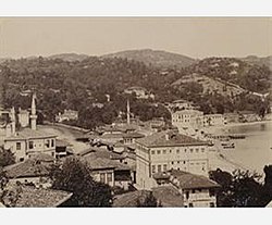 Rize in 1890s
 -
 Rize, 1910s, Ottoman-era postcard


Geography
[edit]The city is built around a small bay on the Black Sea coast, on a narrow strip of flat land between the sea and the mountains behind. The coastal strip is being expanded with landfill and the city is expanding up the steep hillsides away from the coast.
Rize is probably best known for its black tea which was introduced to the region in the 1940s and 1950s, changing the destiny of a region which was until then desperately poor.[13] The local tea research institute was founded in 1958 and other tea gardens can be seen all around the town. Tea is even planted in local gardens. Rize is a centre for processing and shipping locally grown Rize Tea. More recently kiwifruit plants have also been grown in Rize. Fishing remains another important local source of income.
Tourism to destinations in and around Rize is growing in importance.
-

-
 Pokut Yayla is a popular tourism destination
 -
 Tar Creek Waterfall
 -
 Entrance to Rize Castle


Climate
[edit]This Section needs additional citations for verification. (August 2023) |
Rize has a humid subtropical climate (Köppen: Cfa, Trewartha: Cf). However, as any mountainous region of Turkey, it is rich in climatic variety. The climate turns oceanic (Cfb) on the hillsides, continental (Dfb/Dc) and subarctic (Dfc/Eo) on the mountain slopes and in the yaylas, the highlands and highland plateaus.[14] When the Köppen climate classification was being created, the city centre had a borderline oceanic-humid subtropical climate, falling just under the 22 °C (72 °F) threshold for the hottest month of the year, yet climate change and global warming have contributed to the city being classified as humid subtropical in recent decades.[15]
The city's climate is defined by mild temperate conditions, with warm summers, cool winters and heavy rainfall year-round with a maximum in late autumn (October to December). The city has relatively few sunshine hours, lower than many stereotypically cloudy locations in Western Europe. Snowfall is occasional, but can be very heavy once it starts. The water temperature, typical for the Black Sea coast, is never too warm or cold, fluctuating between 8 and 20 °C (46 and 68 °F) throughout the year.
| Climate data for Rize (1991–2020, extremes 1928–2023) | |||||||||||||
|---|---|---|---|---|---|---|---|---|---|---|---|---|---|
| Month | Jan | Feb | Mar | Apr | May | Jun | Jul | Aug | Sep | Oct | Nov | Dec | Year |
| Record high °C (°F) | 26.6 (79.9) |
28.1 (82.6) |
32.6 (90.7) |
35.8 (96.4) |
38.2 (100.8) |
36.1 (97.0) |
35.4 (95.7) |
35.6 (96.1) |
35.0 (95.0) |
33.8 (92.8) |
30.4 (86.7) |
26.7 (80.1) |
38.2 (100.8) |
| Mean daily maximum °C (°F) | 11.0 (51.8) |
11.1 (52.0) |
12.9 (55.2) |
15.9 (60.6) |
20.2 (68.4) |
24.9 (76.8) |
27.4 (81.3) |
28.1 (82.6) |
25.4 (77.7) |
21.4 (70.5) |
16.7 (62.1) |
13.0 (55.4) |
19.0 (66.2) |
| Daily mean °C (°F) | 6.9 (44.4) |
6.8 (44.2) |
8.7 (47.7) |
11.8 (53.2) |
16.6 (61.9) |
21.2 (70.2) |
23.8 (74.8) |
24.5 (76.1) |
21.2 (70.2) |
17.2 (63.0) |
12.1 (53.8) |
8.7 (47.7) |
15.0 (59.0) |
| Mean daily minimum °C (°F) | 3.9 (39.0) |
3.7 (38.7) |
5.4 (41.7) |
8.5 (47.3) |
13.2 (55.8) |
17.5 (63.5) |
20.5 (68.9) |
21.2 (70.2) |
17.7 (63.9) |
13.9 (57.0) |
8.8 (47.8) |
5.6 (42.1) |
11.7 (53.1) |
| Record low °C (°F) | −6.5 (20.3) |
−6.6 (20.1) |
−7 (19) |
−2.8 (27.0) |
4.0 (39.2) |
7.8 (46.0) |
12.0 (53.6) |
13.4 (56.1) |
4.6 (40.3) |
2.5 (36.5) |
−2.6 (27.3) |
−4 (25) |
−7.0 (19.4) |
| Average precipitation mm (inches) | 223.1 (8.78) |
170.5 (6.71) |
154.0 (6.06) |
90.5 (3.56) |
96.6 (3.80) |
148.4 (5.84) |
163.4 (6.43) |
192.5 (7.58) |
265.1 (10.44) |
307.3 (12.10) |
246.0 (9.69) |
252.1 (9.93) |
2,309.5 (90.93) |
| Average precipitation days | 15.33 | 14.5 | 16.8 | 14.83 | 15.13 | 14.83 | 13.7 | 14.63 | 14.8 | 15.4 | 14.13 | 15.5 | 179.58 |
| Average relative humidity (%) | 76.1 | 75.0 | 75.4 | 76.8 | 78.1 | 77.2 | 77.3 | 78.3 | 79.1 | 80.6 | 78.4 | 76.7 | 77.4 |
| Mean monthly sunshine hours | 62.0 | 84.8 | 114.7 | 144.0 | 179.8 | 195.0 | 176.7 | 161.2 | 156.0 | 124.0 | 87.0 | 58.9 | 1,544.1 |
| Mean daily sunshine hours | 2.0 | 3.0 | 3.7 | 4.8 | 5.8 | 6.5 | 5.7 | 5.2 | 5.2 | 4.0 | 2.9 | 1.9 | 4.2 |
| Source 1: Turkish State Meteorological Service[16] | |||||||||||||
| Source 2: NOAA (humidity)[17] | |||||||||||||
Economy and produce
[edit]
Historically, Rize grew oranges. However, weather destroyed the crops in the early 20th century, and the industry declined.[18] The area also produced small amounts of manganese.[19]
Rize's economic structure is primarily based on its geographic location since it is in a very mountainous location, making industrial development impractical. Given the lack of rail transit, most goods have to travel by truck or ship, which makes exporting and importing difficult. Rize's primary trading partner is Trabzon, the most developed city of the northeast Black Sea region. Rize's main exports are agriculturally based; tea and kiwifruit are among its most popular commodities.[20] In particular the state-owned tea company Çaykur is based in Rize.
Education
[edit]Rize University was founded in 2006. Its name was changed to Recep Tayyip Erdoğan University in 2011.
Culture
[edit]Rize Castle is a partly ruined medieval castle to the southwest of the city centre.
Rize Ziraat Botanical Garden, founded in 1924, is two kilometers to the southwest.[21]
Sports
[edit]Rize's sports venues include Rize Atatürk Stadium, Yeni Rize Şehir Stadı and Rize Sports Complex consisting of Rize Sports Hall and Rize Indoor Swimming Pool.
The football team of Çaykur Rizespor play in the Süper Lig. Pazarspor football team compete in the TFF Third League.
Rize Municipality Mayors
[edit]
- Ethem Şevki Kepenek (1950-1954) DP
- Ekrem Orhon (1965-1981) AP
- Şevki Yılmaz (1994-1995) RP
- Hızır Hop (1995-2004) ANAP
- Halil Bakirci (2004-2014) AKP
- Reşat Kasap (2014-2019) AKP
- Rahmi Metin (2019-present) AKP
Notable people
[edit]- Sinem Kobal television and film actress
- Macit Karaahmetoğlu german politician
- Köksal Toptan politician
- Temel Kotil he was the CEO of Turkish Airlines
Population
[edit]| Year | Population |
|---|---|
| 1975 | |
| 1980 | |
| 1985 | |
| 1990 | |
| 1997 | |
| 2000 | |
| 2009 | |
| 2021 |
Notes
[edit]- ^ a b "Address-based population registration system (ADNKS) results dated 31 December 2021" (XLS) (in Turkish). TÜİK. Retrieved 30 January 2023.
- ^ İl Belediyesi, Turkey Civil Administration Departments Inventory. Retrieved 30 January 2023.
- ^ Rize Archived 2008-05-13 at the Wayback Machine article from Özhan Öztürk, Encyclopedia of Black Sea (Karadeniz Ansiklopedik Sözlük), 2005
- ^ Annuario Pontificio 2013 (Libreria Editrice Vaticana, 2013, ISBN 978-88-209-9070-1), p. 959
- ^ Cressoni, B. E. (1854). Dizionario tascabile di geografia universale [Pocket Dictionary of Universal Geography] (in Italian). Turin. p. 370. Retrieved 2024-08-05.
{{cite book}}: CS1 maint: location missing publisher (link) - ^ Schiffner, Albert (1826). Allgemeines deutsches Sach-Wörterbuch aller menschlichen Kenntnisse und Fertigkeiten [General German dictionary of all human knowledge and skills] (in German). Vol. 4. Meissen (Germany): Friedrich Wilhelm Goedsche. p. 488.
- ^ Balbi, Adriano (1824). Compendio di geografia universale [Compendium of universal geography] (in Italian). Vol. 1 (4th ed.). Livorno. p. 370.
- ^ Stein, Christian Gottfried Daniel (1820). Geographisch-statistisches Zeitungs-, Post- und Comtoir-Lexicon [Geographical-statistical news, post and comptoir lexicon] (in German). Vol. 3. Leipzig: Hinrichs. p. 931.
- ^ "Irizeh". Complément du dictionnaire de l'Académie française [Supplement to the dictionary of the French Academy] (in French). Paris: Firmin Didot Frères. 1842. p. 631.
- ^ An Overview of Rize's History
- ^ Περίπλους τοῦ Εὐξείνου Πόντου
- ^ The Periplus of the Euxine Sea. Oxford: sold by J. Cooke; and by Messrs. Cadell and Davies Strand, London. 1805. Note: Arrian only mentions the River Rhizius, not any settlement by that name. It is quoted as being to the east of the river Ophis after the rivers Psychrus and Calus.
- ^ "Rize Çayı ve Rize kenti (tr)". Archived from the original on 2020-05-23. Retrieved 2012-05-15.
- ^ Beck, Hylke E.; Zimmermann, Niklaus E.; McVicar, Tim R.; Vergopolan, Noemi; Berg, Alexis; Wood, Eric F. (2018-10-30). "Present and future Köppen-Geiger climate classification maps at 1-km resolution". Scientific Data. 5 (1): 180214. Bibcode:2018NatSD...580214B. doi:10.1038/sdata.2018.214. hdl:20.500.11850/302311. ISSN 2052-4463. PMC 6207062. PMID 30375988.
- ^ "Climate Explorer: Time series". climexp.knmi.nl. Retrieved 2023-08-22.
- ^ "Resmi İstatistikler: İllerimize Ait Mevism Normalleri (1991–2020)" (in Turkish). Turkish State Meteorological Service. Retrieved 7 August 2021.
- ^ "World Meteorological Organization Climate Normals for 1991-2020 — Rize". National Oceanic and Atmospheric Administration. Retrieved January 17, 2024.
- ^ Prothero, W.G. (1920). Armenia and Kurdistan. London: H.M. Stationery Office. p. 62.
- ^ Prothero, W.G. (1920). Armenia and Kurdistan. London: H.M. Stationery Office. p. 73.
- ^ "Rize". Bologna Course Package, Recep Tayyip Erdoğan Üniversitesi. Retrieved 2021-10-08.
- ^ "Zihni Derin (Agricultural Engineer)". caykur.gov.tr. Archived from the original on January 20, 2024. Retrieved January 20, 2024.
References
[edit]- [Encyclopedic Dictionary of Black Sea]. 2 Cilt. Heyamola Yayıncılık. Istanbul. ISBN 978-975-6121-00-9
External links
[edit] Media related to Rize at Wikimedia Commons
| Municipalities | |
|---|---|
| Villages |
|
| International | |
|---|---|
| National | |
| Geographic | |
| Other | |
Etymology
Name and Linguistic Origins
The name Rize derives from the ancient Greek ῥίζα (rhiza), meaning "root," which in this context refers to the steep mountain slopes or foothills extending from the surrounding peaks to the Black Sea coast.[9] The historical Greek designation for the settlement was Ριζαίον (Rizaion), Rizounta, or Rizous, reflecting its topographic features of rugged, root-like inclines.[10] This etymology aligns with the region's geography, characterized by precipitous terrain unsuitable for extensive flatland settlement.[9] The modern Turkish name Rize represents a phonetic adaptation of the Greek form, retained following the Ottoman incorporation of the area in the 16th century and the establishment of the Turkish Republic in 1923.[10] Local Caucasian languages preserve similar variants: in Laz, it is rendered as Rizini, and in Georgian as რიზე (Rize), indicating linguistic continuity influenced by the historical Pontic Greek presence and indigenous groups in the eastern Black Sea littoral. These forms underscore the name's pre-Turkic roots, predating Ottoman administrative records where the site fell under the sancak of Lazistan.[9]History
Ancient and Classical Periods
The territory of modern Rize lay within the ancient kingdom of Colchis, an early Iron Age polity that arose around the 13th century BCE along the eastern Black Sea coast, extending into parts of present-day northeastern Turkey and western Georgia. Colchis was characterized by advanced metallurgy, with archaeological finds such as bronze axes, cauldrons, and hillforts indicating a hierarchical society reliant on agriculture, herding, and trade in metals and timber. These artifacts, unearthed in Colchian lowland sites, reflect cultural continuity from the Late Bronze Age Colchian culture, which featured megalithic structures and early urbanization precursors.[11] By the 8th century BCE, Colchis appears in Assyrian records as the land of Qulha, a peripheral tribute-paying region exporting bronze items and forest products. In the classical Greek period, from the 6th to 4th centuries BCE, the kingdom maintained semi-independence while engaging in maritime trade with Ionian Greeks, exporting slaves, honey, and wax via emporia like Phasis (modern Poti). Herodotus described Colchians as dark-skinned descendants of Egyptian colonists, noting their circumcision practices and seafaring skills, though such accounts blend ethnography with myth; Strabo later corroborated their role in Black Sea commerce. The region's strategic position facilitated interactions, including the legendary Argonaut expedition mythologized by Apollonius Rhodius around 250 BCE, portraying Colchis as a realm of gold sands and sorcerous kings.[12] Under Achaemenid Persian domination from circa 550 BCE, Colchis functioned as a northern satrapy, contributing troops and resources to Xerxes' campaigns, as evidenced by Persian-style arrowheads found in Colchian graves. Following Alexander the Great's conquests (334–323 BCE), the area briefly fell under Seleucid control before reverting to local dynasts allied with the Hellenistic Kingdom of Pontus. Mithridates VI Eupator of Pontus (r. 120–63 BCE) extended influence eastward, incorporating Colchian territories through marriage alliances and military campaigns against Rome, though direct Roman annexation occurred only after Pompey's victories in 65–63 BCE. Specific settlements in the Rize area, amid steep coastal slopes, supported subsistence economies with limited urban development, as no major classical Greek colonies are attested there unlike in neighboring Sinope or Trapezus. Archaeological evidence remains sparse, with medieval overlays obscuring potential classical layers at sites like Rize Castle.[13]Medieval and Byzantine Era
The region encompassing modern Rize, historically known as Rhizaeon or Rizous, fell under Byzantine control during late antiquity as part of the broader Pontus area and the Lazic kingdom (Egrisi), a Christian buffer state allied with Constantinople against Sassanid Persia. Lazica, including eastern Black Sea coastal territories near Rize, submitted formally to Byzantine overlordship in the early 6th century under Emperor Justin I (r. 518–527), receiving royal insignia and military support in exchange for loyalty. This alliance culminated in the Lazic War (541–562), where Byzantine forces under generals like Peter the Patrician and John the Glutton repelled Sassanid invasions led by Khosrow I, securing Lazica's independence from Persian tribute while affirming Byzantine suzerainty; the conflict ended with a 50-year peace treaty obligating Persia to withdraw and Constantinople to pay annual subsidies to Lazica's king Gubazes II.[14][15] By the 9th century, the area was integrated into the Byzantine administrative system as part of the Theme of Chaldia, a military district centered on Trebizond (Trabzon) that extended eastward to include Rhizaeon and served as a bulwark against Arab raids and later Seljuk incursions. Chaldia, established around 840, relied on local stratēgoi (generals) commanding thematic troops drawn from Greek, Armenian, and indigenous Laz populations, who maintained fortifications like the early castle at Rize for defense and trade oversight along the Black Sea route. The theme's economy centered on silk production, agriculture in fertile valleys, and maritime commerce, with Rhizaeon functioning as a minor port facilitating grain and timber exports to Constantinople.[16] Following the Fourth Crusade's sack of Constantinople in 1204, Rhizaeon and surrounding territories passed to the Empire of Trebizond, a Komnenian successor state claiming Byzantine imperial continuity under the Megas Komnenos dynasty. Trebizond's rulers, such as Alexios I (r. 1204–1222), expanded control over eastern Pontus including Rize, fortifying coastal strongholds against Georgian, Seljuk, and Mongol pressures while fostering Orthodox Christianity among Greek and Laz inhabitants. The empire endured as a culturally Byzantine entity until its conquest by Ottoman Sultan Mehmed II in 1461, after which Rhizaeon retained local significance under early Ottoman sanjaks.[17][18]Ottoman Period
Rize, historically known as Rizonda or Rizounta, was incorporated into the Ottoman Empire following the conquest of the Empire of Trebizond in 1461 by Sultan Mehmed II, marking the end of Byzantine successor rule in the region.[19] The area, part of the historic Georgian province of Chaneti, became integrated into the Ottoman administrative framework initially under the Trabzon Eyalet, with districts such as Atina (modern Pazar), Hemşin, and Arhavi falling under Ottoman control shortly after the 1461 campaign.[20] Administratively, Rize formed part of the Lazistan Sanjak within the Trebizond Vilayet, serving as the seat of the sanjak governor and encompassing the Laz-speaking coastal territories along the southeastern Black Sea shore.[21] From 1878 onward, Rize explicitly functioned as the capital of the Lazistan Sanjak, reflecting its strategic importance as a port and administrative hub.[10] Ottoman archival records, including the 1495 Rize Şer’iyye Registers and Trabzon Province Salnames from 1877, document local governance, land tenure, and judicial matters, while late-17th-century infrastructure projects involved constructing multiple bridges across the Fırtına River and its tributaries to facilitate connectivity.[20] The local economy during the Ottoman era centered on agriculture and textile production, with weaving emerging as a vital sector; by the 16th century, 258 households in Rize engaged in producing Rize Bezi, a linen fabric derived from hemp (kendir) and flax (keten), used for clothing and household goods.[22] This industry scaled up in the 19th century, with exports of Rize and Trabzon bezi reaching Istanbul, Syria, Yemen, and international markets, as evidenced by tax records from 1727–1820 showing revenues like 500 kuruş in weaving taxes and displays at exhibitions in 1851, 1855, and 1862.[22] Socially, weaving influenced community structures, with shared production tools fostering local cooperation and contributing to place names like Kendirli village. By the early 20th century, prior to World War I, the town's population stood at around 5,000, predominantly Muslim Laz speakers, though the region faced economic strains during the war as one of the Ottoman fronts.[10][23][24]Republican Era and Modern Developments
Following the proclamation of the Republic of Turkey on October 29, 1923, Rize integrated into the new state as an administrative unit in the Black Sea region, with its status formalized as a province by 1924. The area, previously marked by economic hardship and reliance on rudimentary agriculture and coastal trade, underwent gradual modernization efforts aligned with national policies promoting agricultural diversification and infrastructure. Population data from the first Republican census in 1927 recorded 171,667 residents in Rize, reflecting a stable base amid broader national resettlement and Turkification initiatives under Law 1164 of June 1927.[25] The pivotal economic shift occurred through tea cultivation, initiated experimentally in the 1920s after researchers identified the Black Sea's humid subtropical conditions as ideal, akin to those in major producers like Sri Lanka. Small-scale processing workshops appeared by the late 1930s, but industrial-scale production commenced with the opening of Rize's first tea factory in 1947, equipped with machinery ordered from England in 1940 and boasting an initial capacity of 60 tons per day.[26] [27] By the 1950s, tea plantations covered expansive hillsides, establishing Rize as Turkey's dominant tea hub and generating substantial employment; annual output reached levels supporting national consumption while elevating local incomes from poverty to relative affluence.[28] [29] Administrative elevation to full provincial independence occurred on March 2, 1953, separating Rize from Trabzon Province to enhance local governance amid growing economic significance. Subsequent decades saw population expansion tied to tea-driven migration and natural increase, with the province's residents rising to over 300,000 by the early 21st century. Infrastructure advanced incrementally, including road widenings along the Black Sea coast following Georgia's border opening in the early 1990s, which spurred trade and tourism.[30] In recent developments, higher education expanded with the founding of Rize University (later renamed Recep Tayyip Erdoğan University) on March 17, 2006, via Law No. 5467, fostering research in agriculture, fisheries, and environmental sciences pertinent to the region's topography. Transportation infrastructure modernized further with the Rize-Artvin Airport's construction from 2020 to 2021 in Pazar district, improving connectivity and supporting tourism to yaylas (highland plateaus) and natural sites. Ongoing projects include the İyidere Logistics Center, reaching 60% completion by May 2025 with a planned 215,000 square meters of storage to bolster tea exports and regional logistics. Mass housing initiatives, such as the 2011 Rize Disaster Residences covering 22,000 square meters, addressed vulnerabilities from landslides and floods inherent to the steep terrain.[31] [32] [33]Geography
Location and Topography
Rize Province occupies a position in northeastern Turkey along the eastern Black Sea coast, extending between the provinces of Trabzon to the west and Artvin to the east, with Erzurum and Bayburt bordering it to the south.[34] The provincial capital, Rize city, is situated at coordinates 41°01′32″N 40°31′04″E, approximately 66 km east of Trabzon.[35] Covering an area of 3,922 km², the province features a population density of 88 people per km² as of recent data.[34] The topography of Rize is markedly rugged, dominated by the Pontic Mountains that parallel the Black Sea shoreline, resulting in a narrow coastal plain limited to a thin strip of flat land backing onto steep, wooded hills.[36] Elevations rise rapidly inland, with the city of Rize at sea level averaging around 14 meters, while the provincial average elevation reaches 1,171 meters.[37][38] The landscape includes deep valleys carved by rivers, high plateaus known as yaylas, and alpine terrain in the Kaçkar Mountains, a subrange of the Eastern Black Sea Mountains within the Pontic system.[36] The Kaçkar Mountains form the most prominent topographic feature, with their highest peak, Kaçkar Dağı, elevating to 3,932 meters above sea level, located roughly 70 km east of Rize city and overlooking the Black Sea.[39][40] This range, composed primarily of granite and crystalline schists formed during the Alpine-Himalayan orogeny, supports glacial features, steep slopes, and biodiversity-rich ecosystems, contributing to the province's isolation from interior Anatolia due to its precipitous terrain. The combination of coastal humidity and mountainous barriers shapes a topography conducive to intensive rainfall and limited arable flatland, primarily suited for terraced agriculture.[36]Administrative Divisions and Settlements
Rize Province is administratively divided into twelve districts (ilçeler): Ardeşen, Çamlıhemşin, Çayeli, Derepazarı, Fındıklı, Güneysu, Hemşin, İkizdere, İyidere, Kalkandere, Pazar, and the central Rize District (Merkez).[41][42] Each district functions as a local administrative unit governed by a kaymakam (district governor) appointed by the central government, overseeing sub-divisions including neighborhoods (mahalleler) and villages (köyler).[43] The provincial capital and largest settlement is the city of Rize, situated in the central district, which accounts for a significant portion of the province's urban population. As of 2023, the total population of Rize Province was 350,506, with the majority concentrated in coastal districts due to topography favoring settlement along the Black Sea littoral.[44] Rural areas predominate inland, with over 350 villages supporting dispersed agricultural communities focused on tea cultivation and horticulture.[34]| District | Key Characteristics |
|---|---|
| Ardeşen | Coastal industrial hub with timber processing; population ~39,000 (2022 est.).[45] |
| Çayeli | Major tea-producing area; population ~41,000 (2022 est.).[45] |
| Rize (Merkez) | Provincial seat with urban infrastructure; population ~135,000 (older est., central district).[46] |
| Pazar | Bordering Artvin; known for hazelnut production; population ~30,000 (older est.).[46] |
Climate
Climatic Characteristics and Patterns
Rize province features a humid subtropical climate (Köppen classification Cfa), marked by mild temperatures, high humidity, and copious rainfall throughout the year, driven by the moderating influence of the Black Sea and orographic effects from the adjacent Pontic Mountains. Annual mean temperatures average 12.5–13.9 °C, with winter lows in January and February rarely dropping below 7.5 °C and summer highs in August peaking at 24.5 °C.[47][48][49] Precipitation exceeds 2,000 mm annually, positioning Rize among Turkey's wettest areas, with totals reaching up to 2,300 mm in some records; rainfall occurs in every month, lacking a pronounced dry season, though autumn (particularly October) sees the heaviest downpours, averaging 288.7 mm.[48][50] The even distribution stems from consistent maritime air flows, but mountainous terrain amplifies convective and orographic precipitation, leading to frequent fog, overcast skies, and wet days numbering over 200 annually.[51] Seasonal patterns include cool, damp winters with occasional frost at higher elevations and warm, humid summers prone to thunderstorms; relative humidity consistently surpasses 80%, fostering dense vegetation but elevating landslide risks during intense rains. Extreme events, such as floods from prolonged wet spells, have intensified with climate variability, though long-term data indicate stable averages without significant aridification.[51][52]| Month | Avg. High (°C) | Avg. Low (°C) | Precipitation (mm) |
|---|---|---|---|
| January | 11.5 | 5.0 | 200–250 |
| April | 15.0 | 8.0 | 97–122 |
| July | 25.0 | 18.0 | 150–200 |
| October | 20.0 | 13.0 | 250–289 |
Demographics
Population Trends and Statistics
The population of Rize Province was recorded at 346,977 as of December 31, 2024, by the Turkish Statistical Institute (TÜİK), reflecting a decrease of 3,529 people or 1.01% from 350,506 in 2023.[53][54] This decline occurred across most districts, with notable drops in İyidere and Derepazarı, amid a provincial net migration rate that has turned negative in recent years, offsetting earlier natural population increases from births exceeding deaths.[55] The provincial capital, Rize district, holds 151,617 residents, comprising about 43.7% of the total.[55] Historical data from TÜİK indicate steady but modest growth from the early 2000s, when the population stood at roughly 322,103 in 2000, expanding to 343,212 by 2019 and peaking near 350,000 in 2023.[43] Annual growth rates during 2000–2020 averaged 0.5–1%, driven by improved healthcare access and tea agriculture sustaining rural livelihoods, though constrained by the province's rugged topography limiting large-scale urbanization.[34] Post-2020 stagnation and the 2024 reversal align with broader Black Sea regional patterns of out-migration to industrial hubs, as younger cohorts seek employment beyond agriculture.[43] Urbanization has progressed, with 71.6% of residents in urban settings by 2024, up from lower shares in earlier censuses, as rural villages depopulate.[53] Population density remains low at 90.5 persons per km² across 3,835 km², concentrated along the Black Sea coast.[43]| Year | Population | Annual Change (%) |
|---|---|---|
| 2000 | 322,103 | - |
| 2019 | 343,212 | ~0.6 (avg. 2000–2019) |
| 2020 | 344,359 | +0.3 |
| 2021 | 345,662 | +0.4 |
| 2022 | 344,016 | -0.5 |
| 2023 | 350,506 | +1.9 |
| 2024 | 346,977 | -1.0 |