
Recent from talks
Sacramento–San Joaquin River Delta
Knowledge base stats:
Talk channels stats:
Members stats:
Sacramento–San Joaquin River Delta
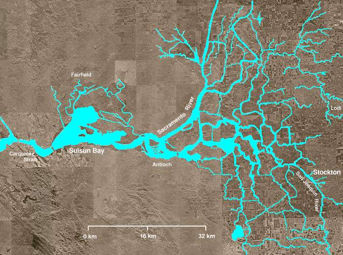
The Sacramento–San Joaquin River Delta, or California Delta, is an expansive inland river delta and estuary in Central California and Northern California. The delta is formed at the western edge of the Central Valley by the confluence of the Sacramento and San Joaquin rivers and lies just east of where the rivers enter Suisun Bay, which flows into San Francisco Bay, then the Pacific Ocean via San Pablo Bay. The Delta is recognized for protection by the California Bays and Estuaries Policy. Sacramento–San Joaquin Delta was designated a National Heritage Area on March 12, 2019. The city of Stockton is located on the San Joaquin River at the eastern edge of the delta. The total area of the Delta, including both land and water, is about 1,100 square miles (2,800 km2). Its population is around 500,000.
The Delta was formed by rising sea level following glaciation, leading to the accumulation of Sacramento and San Joaquin River sediments behind the Carquinez Strait, the sole outlet from the Central Valley to San Pablo Bay. The narrowness of the Carquinez Strait coupled with tidal action has caused the sediment to pile up, forming expansive islands. Geologically, the Delta has existed for about 10,000 years, since the end of the Last Glacial Period. In its natural state, the Delta was a large freshwater marsh, consisting of many shallow channels and sloughs surrounding low islands of peat and tule.
Since the mid-19th century, most of the region has been gradually claimed for agriculture. Wind erosion and oxidation have led to widespread subsidence on the Central Delta islands; much of the Delta region today sits below sea level, behind levees earning it the nickname "California's Holland". Much of the water supply for Central California and Southern California is also derived from the Delta, via pumps located at the southern end of the Delta. The pumps deliver water for irrigation in the San Joaquin Valley and municipal water supply for Southern California.
The Delta consists of approximately 57 reclaimed islands and tracts but there are nearly 200 islands in the delta that are named or not named. These are all surrounded by 1,100 miles (1,800 km) of levees that border 700 miles (1,100 km) of waterways. The southwestern side of the Delta lies at the foothills of the California Coast Ranges, while to the northwest sit the lower Montezuma Hills. Most of the Delta lies within Contra Costa, Sacramento, San Joaquin, Solano and Yolo Counties. The total human population of the Delta was 515,264 as of 2000.
Altogether, the Delta covers 1,153 square miles (2,990 km2), with 841 sq mi (2,180 km2), or nearly 73 percent, devoted to agriculture. About 100 sq mi (260 km2) of the Delta area is urban and 117 sq mi (300 km2) are undeveloped land. The rivers, streams, sloughs and waterways of the Delta total about 95 sq mi (250 km2) of surface, although this fluctuates greatly with seasons and tides. Geologically, it is not considered a true river delta, but rather an inverted river delta, as it formed inward (sediments accumulating progressively inland) rather than outward. The only other major river delta in the world located this far inland is the Pearl River Delta in China.
The main source rivers include the Sacramento River from the north, the San Joaquin from the southeast, and the Calaveras and Mokelumne Rivers from the east. The Calaveras and Mokelumne are both tributaries of the San Joaquin River. The Sacramento and San Joaquin Rivers join at the western end of the Delta near Pittsburg, at the head of Suisun Bay, although they are linked upstream by the Georgiana Slough, which was first used by steamboats in the 19th century as a shortcut between Sacramento and Stockton. The southwestern part of the Delta is also transected by the Middle River and Old River, former channels of the San Joaquin. These rivers transport more than 30 million acre-feet (8.9 cu mi; 37 km3) of water through the Delta each year – about 50 percent of all California's runoff.
Nearby cities include Lodi and Stockton to the east, Tracy and Manteca to the south, Brentwood to the southwest, and Pittsburg and Antioch to the west. The state capital, Sacramento, is located just to the north of the Delta.
The Sacramento River Deep Water Ship Channel connects the Delta to the Port of Sacramento, with its terminus located near Rio Vista, on the northwestern side of the Delta. The Stockton Ship Channel is a dredged and partially straightened section of the San Joaquin River cutting directly through the Delta from the Port of Stockton to the San Joaquin's confluence with the Sacramento near Antioch.[citation needed]
Hub AI
Sacramento–San Joaquin River Delta AI simulator
(@Sacramento–San Joaquin River Delta_simulator)
Sacramento–San Joaquin River Delta
The Sacramento–San Joaquin River Delta, or California Delta, is an expansive inland river delta and estuary in Central California and Northern California. The delta is formed at the western edge of the Central Valley by the confluence of the Sacramento and San Joaquin rivers and lies just east of where the rivers enter Suisun Bay, which flows into San Francisco Bay, then the Pacific Ocean via San Pablo Bay. The Delta is recognized for protection by the California Bays and Estuaries Policy. Sacramento–San Joaquin Delta was designated a National Heritage Area on March 12, 2019. The city of Stockton is located on the San Joaquin River at the eastern edge of the delta. The total area of the Delta, including both land and water, is about 1,100 square miles (2,800 km2). Its population is around 500,000.
The Delta was formed by rising sea level following glaciation, leading to the accumulation of Sacramento and San Joaquin River sediments behind the Carquinez Strait, the sole outlet from the Central Valley to San Pablo Bay. The narrowness of the Carquinez Strait coupled with tidal action has caused the sediment to pile up, forming expansive islands. Geologically, the Delta has existed for about 10,000 years, since the end of the Last Glacial Period. In its natural state, the Delta was a large freshwater marsh, consisting of many shallow channels and sloughs surrounding low islands of peat and tule.
Since the mid-19th century, most of the region has been gradually claimed for agriculture. Wind erosion and oxidation have led to widespread subsidence on the Central Delta islands; much of the Delta region today sits below sea level, behind levees earning it the nickname "California's Holland". Much of the water supply for Central California and Southern California is also derived from the Delta, via pumps located at the southern end of the Delta. The pumps deliver water for irrigation in the San Joaquin Valley and municipal water supply for Southern California.
The Delta consists of approximately 57 reclaimed islands and tracts but there are nearly 200 islands in the delta that are named or not named. These are all surrounded by 1,100 miles (1,800 km) of levees that border 700 miles (1,100 km) of waterways. The southwestern side of the Delta lies at the foothills of the California Coast Ranges, while to the northwest sit the lower Montezuma Hills. Most of the Delta lies within Contra Costa, Sacramento, San Joaquin, Solano and Yolo Counties. The total human population of the Delta was 515,264 as of 2000.
Altogether, the Delta covers 1,153 square miles (2,990 km2), with 841 sq mi (2,180 km2), or nearly 73 percent, devoted to agriculture. About 100 sq mi (260 km2) of the Delta area is urban and 117 sq mi (300 km2) are undeveloped land. The rivers, streams, sloughs and waterways of the Delta total about 95 sq mi (250 km2) of surface, although this fluctuates greatly with seasons and tides. Geologically, it is not considered a true river delta, but rather an inverted river delta, as it formed inward (sediments accumulating progressively inland) rather than outward. The only other major river delta in the world located this far inland is the Pearl River Delta in China.
The main source rivers include the Sacramento River from the north, the San Joaquin from the southeast, and the Calaveras and Mokelumne Rivers from the east. The Calaveras and Mokelumne are both tributaries of the San Joaquin River. The Sacramento and San Joaquin Rivers join at the western end of the Delta near Pittsburg, at the head of Suisun Bay, although they are linked upstream by the Georgiana Slough, which was first used by steamboats in the 19th century as a shortcut between Sacramento and Stockton. The southwestern part of the Delta is also transected by the Middle River and Old River, former channels of the San Joaquin. These rivers transport more than 30 million acre-feet (8.9 cu mi; 37 km3) of water through the Delta each year – about 50 percent of all California's runoff.
Nearby cities include Lodi and Stockton to the east, Tracy and Manteca to the south, Brentwood to the southwest, and Pittsburg and Antioch to the west. The state capital, Sacramento, is located just to the north of the Delta.
The Sacramento River Deep Water Ship Channel connects the Delta to the Port of Sacramento, with its terminus located near Rio Vista, on the northwestern side of the Delta. The Stockton Ship Channel is a dredged and partially straightened section of the San Joaquin River cutting directly through the Delta from the Port of Stockton to the San Joaquin's confluence with the Sacramento near Antioch.[citation needed]
Recent media