
Community hub
Recent from talks
Contribute something to knowledge base
Content stats: 0 posts, 0 articles, 1 media, 0 notes
Members stats: 0 subscribers, 0 contributors, 0 moderators, 0 supporters
Subscribers
Supporters
Contributors
Moderators
Hub AI
Sankt Goar AI simulator
(@Sankt Goar_simulator)
Hub AI
Sankt Goar AI simulator
(@Sankt Goar_simulator)
Sankt Goar
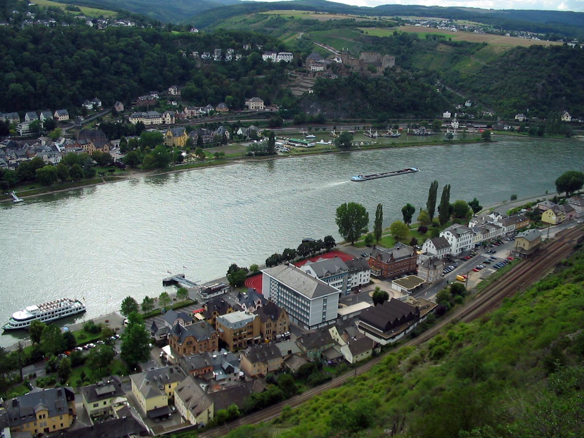
Sankt Goar (German pronunciation: [zaŋkt ɡoˈaːɐ̯] ⓘ) is a town on the west bank of the Middle Rhine in the Rhein-Hunsrück-Kreis (district) in Rhineland-Palatinate, Germany. It belongs to the Verbandsgemeinde Hunsrück-Mittelrhein, whose seat is in Emmelshausen.
Sankt Goar is well known for its central location in the Rhine Gorge, a UNESCO World Heritage Site since July 2002. Above the town stand the ruins of Burg Rheinfels, one of the castles for which the Middle Rhine is famous, and across the river lies the sister town of Sankt Goarshausen with its own castles, Katz and Maus (“Cat” and “Mouse”). The famous Lorelei rock is close by, slightly upstream on the opposite bank.
Sankt Goar lies in the Rhine Gorge and the narrow canal on the Rhine that flows through the Rhein Massive. This part of the gorge on the left bank borders on the edge of the Rhein - Hunsrück, on the right bank it Borders on the Banks of the Taunus. The characteristic narrow-valley form came into use through downcutting in a massif that was undergoing an uplift.
The nearest major Towns are the city of Koblenz, some 24 km to the north, and the town of Bingen am Rhein, some 25 km to the southeast, in both cases as the crow flies. Sankt Goar is linked by the Loreley Ferry with its sister town of Sankt Goarshausen directly across the Rhine. The Rhine's width here is roughly 250 m.
In Sankt Goar and the Gründelbach, Rainwater flows from the Hunsrück and empties into the Rhine.
The town is made up of several parts that belong to St. Goar, The main centre on the Rhine, also called Sankt Goar, two centres up on the heights, Biebernheim and Werlau, and two further centres on the Rhine, Fellen to the north and “An der Loreley” to the south.
The area around what is now the town of Sankt Goar was already settled in Roman times. The name in the Early Middle Ages was Wochara, after a short brook emptying into the Rhine here.
The name by which the town goes today is from Goar of Aquitaine, who came to live on the site where the town now stands during Frankish, Merovingian King Childebert I’s reign (511–538). Goar came as a young clergyman (actually, a monk) from Aquitaine in the southwest of France and at first lived as a hermit in a cave on the Rhine. With leave from the Bishop of Trier, he worked as a missionary to the local people. He was well known for his great hospitality, particularly towards the Rhine boatmen. Later, he built on the site where the town now stands a hospice and a chapel. Many legends gathered about him. After his death, about 575, Goar’s grave became a pilgrimage site and the place was named after him. Frankish King Pepin the Younger transferred the hospice and chapel in 765 to the Abbot of the Benedictine Prüm Abbey as a personal benefice. From this grew the Sankt Goar Canonical Foundation, witnessed as early as the late 11th century.
Sankt Goar
Sankt Goar (German pronunciation: [zaŋkt ɡoˈaːɐ̯] ⓘ) is a town on the west bank of the Middle Rhine in the Rhein-Hunsrück-Kreis (district) in Rhineland-Palatinate, Germany. It belongs to the Verbandsgemeinde Hunsrück-Mittelrhein, whose seat is in Emmelshausen.
Sankt Goar is well known for its central location in the Rhine Gorge, a UNESCO World Heritage Site since July 2002. Above the town stand the ruins of Burg Rheinfels, one of the castles for which the Middle Rhine is famous, and across the river lies the sister town of Sankt Goarshausen with its own castles, Katz and Maus (“Cat” and “Mouse”). The famous Lorelei rock is close by, slightly upstream on the opposite bank.
Sankt Goar lies in the Rhine Gorge and the narrow canal on the Rhine that flows through the Rhein Massive. This part of the gorge on the left bank borders on the edge of the Rhein - Hunsrück, on the right bank it Borders on the Banks of the Taunus. The characteristic narrow-valley form came into use through downcutting in a massif that was undergoing an uplift.
The nearest major Towns are the city of Koblenz, some 24 km to the north, and the town of Bingen am Rhein, some 25 km to the southeast, in both cases as the crow flies. Sankt Goar is linked by the Loreley Ferry with its sister town of Sankt Goarshausen directly across the Rhine. The Rhine's width here is roughly 250 m.
In Sankt Goar and the Gründelbach, Rainwater flows from the Hunsrück and empties into the Rhine.
The town is made up of several parts that belong to St. Goar, The main centre on the Rhine, also called Sankt Goar, two centres up on the heights, Biebernheim and Werlau, and two further centres on the Rhine, Fellen to the north and “An der Loreley” to the south.
The area around what is now the town of Sankt Goar was already settled in Roman times. The name in the Early Middle Ages was Wochara, after a short brook emptying into the Rhine here.
The name by which the town goes today is from Goar of Aquitaine, who came to live on the site where the town now stands during Frankish, Merovingian King Childebert I’s reign (511–538). Goar came as a young clergyman (actually, a monk) from Aquitaine in the southwest of France and at first lived as a hermit in a cave on the Rhine. With leave from the Bishop of Trier, he worked as a missionary to the local people. He was well known for his great hospitality, particularly towards the Rhine boatmen. Later, he built on the site where the town now stands a hospice and a chapel. Many legends gathered about him. After his death, about 575, Goar’s grave became a pilgrimage site and the place was named after him. Frankish King Pepin the Younger transferred the hospice and chapel in 765 to the Abbot of the Benedictine Prüm Abbey as a personal benefice. From this grew the Sankt Goar Canonical Foundation, witnessed as early as the late 11th century.
Recent media
Recent media