
Community hub
Recent from talks
Contribute something to knowledge base
Content stats: 0 posts, 0 articles, 1 media, 0 notes
Members stats: 0 subscribers, 0 contributors, 0 moderators, 0 supporters
Subscribers
Supporters
Contributors
Moderators
Hub AI
Santa Lucia Range AI simulator
(@Santa Lucia Range_simulator)
Hub AI
Santa Lucia Range AI simulator
(@Santa Lucia Range_simulator)
Santa Lucia Range
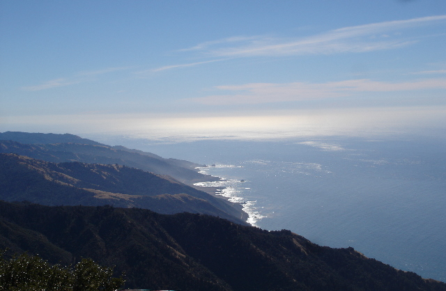
The Santa Lucia Range (sæntə luˈsiːə) or Santa Lucia Mountains is a rugged mountain range in coastal Central California, running from Carmel southeast for 140 miles (230 km) to the Cuyama River in San Luis Obispo County. The range is never more than 11 miles (18 km) from the coast. The range forms the steepest coastal slope in the contiguous United States. Cone Peak at 5,158 feet (1,572 m) tall and three miles (5 km) from the coast, is the highest peak in proximity to the ocean in the lower 48 United States. The range was a barrier to exploring the coast of central California for early Spanish explorers.
The Santa Lucia Range is part of the Outer South California Coast Ranges, in the Pacific Coast Ranges System. The coastal side of the range rises directly from the shoreline, with oceanfront ridges rising directly 4,000 to 5,000 feet (1,200 to 1,500 m) to the crest of the coastal range. The crest of the range is never more than 11 miles (18 km) from the coast. Cone Peak is the steepest coastal elevation in the contiguous United States, rising nearly a mile (1,609 m) above sea level, only three miles (5 km) from the Pacific Ocean.
The range's northern section runs parallel to the southern section of the Diablo Range, part of the Inner South Coast Ranges, which lies to the east across the Salinas Valley. The range's highest summit is Junipero Serra Peak, 1,784 metres (5,853 ft) in Monterey County and the Los Padres National Forest.
The first European to document the Santa Lucias was Juan Rodríguez Cabrillo in 1542 while sailing northward along the coast on a Spanish naval expedition. Cabrillo originally named the southern portion of the range the Sierras de San Martín, as he was passing the area on November 11, the feast day for Saint Martin. He named the northern part Sierras Nevadas because there was snow on it.
The present name for the range was documented in 1602 by Sebastián Vizcaíno, who had been tasked by the Spanish to complete a detailed chart of the coast. Passing by the range around December 14th, he named the range Sierra de Santa Lucia in honor of Saint Lucy of Syracuse, for whom many Christians celebrate the feast of Saint Lucy's Day on December 13th.
The first European land exploration of Alta California, the Spanish Portolá expedition, camped on the coast near Ragged Point in present-day San Luis Obispo County on September 13, 1769. The expedition was forced to bypass the inaccessible coast and travel inland through the San Antonio Valley. The rough trail required much improvement by the scouts, and it was September 24 before the party emerged from the mountains at the San Antonio River near today's settlement of Jolon. They traveled north through the Salinas Valley before arriving at Monterey Bay, where they founded Monterey and named it their capital.
Like other Pacific Coast Ranges, the mountains' close proximity to the Pacific Ocean causes moisture to be deposited on the west-facing slopes, creating a suitable environment for conifers. This creates a rain shadow over the Salinas Valley to the east, which is considerably drier. The higher peaks receive some snowfall during the winter.
The climate is classified as dry summer subtropical, or Mediterranean. Rainfall varies from 16 to 60 inches (41 to 152 cm) throughout the range. Most of the precipitation falls during the winter on the higher mountains in the north. During the summer, fog and low clouds are frequent along the coast up to an elevation of 2–3,000 feet. Surface runoff from rainfall is rapid, and many streams dry up entirely in the summer, except for some perennial streams in the wetter areas in the north.
Santa Lucia Range
The Santa Lucia Range (sæntə luˈsiːə) or Santa Lucia Mountains is a rugged mountain range in coastal Central California, running from Carmel southeast for 140 miles (230 km) to the Cuyama River in San Luis Obispo County. The range is never more than 11 miles (18 km) from the coast. The range forms the steepest coastal slope in the contiguous United States. Cone Peak at 5,158 feet (1,572 m) tall and three miles (5 km) from the coast, is the highest peak in proximity to the ocean in the lower 48 United States. The range was a barrier to exploring the coast of central California for early Spanish explorers.
The Santa Lucia Range is part of the Outer South California Coast Ranges, in the Pacific Coast Ranges System. The coastal side of the range rises directly from the shoreline, with oceanfront ridges rising directly 4,000 to 5,000 feet (1,200 to 1,500 m) to the crest of the coastal range. The crest of the range is never more than 11 miles (18 km) from the coast. Cone Peak is the steepest coastal elevation in the contiguous United States, rising nearly a mile (1,609 m) above sea level, only three miles (5 km) from the Pacific Ocean.
The range's northern section runs parallel to the southern section of the Diablo Range, part of the Inner South Coast Ranges, which lies to the east across the Salinas Valley. The range's highest summit is Junipero Serra Peak, 1,784 metres (5,853 ft) in Monterey County and the Los Padres National Forest.
The first European to document the Santa Lucias was Juan Rodríguez Cabrillo in 1542 while sailing northward along the coast on a Spanish naval expedition. Cabrillo originally named the southern portion of the range the Sierras de San Martín, as he was passing the area on November 11, the feast day for Saint Martin. He named the northern part Sierras Nevadas because there was snow on it.
The present name for the range was documented in 1602 by Sebastián Vizcaíno, who had been tasked by the Spanish to complete a detailed chart of the coast. Passing by the range around December 14th, he named the range Sierra de Santa Lucia in honor of Saint Lucy of Syracuse, for whom many Christians celebrate the feast of Saint Lucy's Day on December 13th.
The first European land exploration of Alta California, the Spanish Portolá expedition, camped on the coast near Ragged Point in present-day San Luis Obispo County on September 13, 1769. The expedition was forced to bypass the inaccessible coast and travel inland through the San Antonio Valley. The rough trail required much improvement by the scouts, and it was September 24 before the party emerged from the mountains at the San Antonio River near today's settlement of Jolon. They traveled north through the Salinas Valley before arriving at Monterey Bay, where they founded Monterey and named it their capital.
Like other Pacific Coast Ranges, the mountains' close proximity to the Pacific Ocean causes moisture to be deposited on the west-facing slopes, creating a suitable environment for conifers. This creates a rain shadow over the Salinas Valley to the east, which is considerably drier. The higher peaks receive some snowfall during the winter.
The climate is classified as dry summer subtropical, or Mediterranean. Rainfall varies from 16 to 60 inches (41 to 152 cm) throughout the range. Most of the precipitation falls during the winter on the higher mountains in the north. During the summer, fog and low clouds are frequent along the coast up to an elevation of 2–3,000 feet. Surface runoff from rainfall is rapid, and many streams dry up entirely in the summer, except for some perennial streams in the wetter areas in the north.
Recent media
Recent media