Recent from talks
Sirte Basin
Knowledge base stats:
Talk channels stats:
Members stats:
Sirte Basin
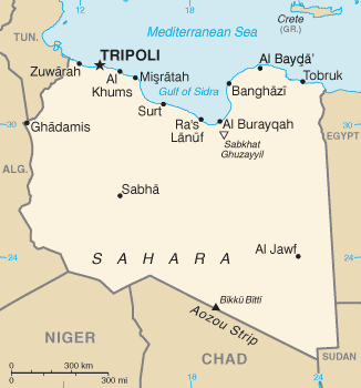
The Sirte Basin is a late Mesozoic and Cenozoic triple junction continental rift (extensional basin) along northern Africa that was initiated during the late Jurassic Period. It borders a relatively stable Paleozoic craton and cratonic sag basins along its southern margins. The province extends offshore into the Mediterranean Sea, with the northern boundary drawn at the 2,000 meter (m) bathymetric contour. It borders in the north on the Gulf of Sidra and extends south into northern Chad.
The Sirte Basin ranks 13th among the world's petroleum provinces, having proven oil reserves estimated at 43.1 billion barrels (6.85×10⁹ m3) of oil equivalent (36.7 bbl, 37.7×10¹² cu ft (1,070 km3) of gas, 0.1 bbl (0.016 m3) of NGL), an amount that constitutes 1.7% of the world’s known oil reserves. The basin consists of one dominant total petroleum system, known as the Sirte-Zelten.
The Late Cretaceous Sirte Shale is the primary hydrocarbon source bed. Reservoirs range in rock type and age from fractured Precambrian basement, clastic reservoirs in the Cambrian-Ordovician Gargaf Sandstone, and Lower Cretaceous Nubian Sandstone to Paleocene Zelten Formation and Eocene carbonates usually in the form of bioherms.
Hydrocarbon generation commenced about 50 million years ago (Ma) in the deeper basins, about 40 Ma in many other areas, and may continue to the present day. Geothermal gradients generally range from 1 °F/100 ft to 1.8 °F/100 ft; horsts and grabens generally have roughly equivalent thermal regimes relative to the primary source rock. Along the southwest and west margins of the province are extrusive igneous deposits that tend to diminish the hydrocarbon potential of these areas. The Gialo High is a relatively small horst block in the eastern Sirte Basin. It is most important and primarily known for the stacked oil fields in rocks ranging from the Early Cretaceous to Oligocene age. There are several billion barrels of oil reserves associated with the structure both over the crest of the horst as well as flanking the high in the adjacent graben.
Notes:
1. USGS 2002.
The land area in the Sirte basin is characterized by desert steppes and includes eolian deposits from the Rebiana and Kalansho Sand Sea of the Sahara Desert. In a relatively narrow, northern coastal strip, some land areas are as much as 47 m below sea level. The basin is floored by a northwest-southeast-trending mosaic of narrow horsts and grabens, an important structural characteristic that distinguishes it from the adjacent intracratonic Kufra, Murzuk, and Ghadames basins.
The area of the Sirte Basin occupies about 230,000 km2, with a wildcat drilling density of one new field wildcat per 145 km2. Overall drilling density of the basin is 3.3 wells per 100 km2, with an average field depth of 2,100 m. Recent indications of hydrocarbons within grabens suggest that these areas have potential as well as clastic reservoirs beneath the carbonate reservoirs in the Central Sirte Basin. The offshore area beyond 200 m depths is largely unexplored.
The Sirte Basin province is considered to be a type locality of a continental rift (extensional) area and is referred to as part of the Tethyan rift system. According to the designation scheme of Bally and Snelson, it is classified as 1211; a cratonic basin located on earlier rifted grabens on a rigid lithosphere and not associated with formation of megasutures. Clifford terms it as an interior fracture basin near the tectonic plate margin, which characteristically has an axis at an angle to that margin.
Hub AI
Sirte Basin AI simulator
(@Sirte Basin_simulator)
Sirte Basin
The Sirte Basin is a late Mesozoic and Cenozoic triple junction continental rift (extensional basin) along northern Africa that was initiated during the late Jurassic Period. It borders a relatively stable Paleozoic craton and cratonic sag basins along its southern margins. The province extends offshore into the Mediterranean Sea, with the northern boundary drawn at the 2,000 meter (m) bathymetric contour. It borders in the north on the Gulf of Sidra and extends south into northern Chad.
The Sirte Basin ranks 13th among the world's petroleum provinces, having proven oil reserves estimated at 43.1 billion barrels (6.85×10⁹ m3) of oil equivalent (36.7 bbl, 37.7×10¹² cu ft (1,070 km3) of gas, 0.1 bbl (0.016 m3) of NGL), an amount that constitutes 1.7% of the world’s known oil reserves. The basin consists of one dominant total petroleum system, known as the Sirte-Zelten.
The Late Cretaceous Sirte Shale is the primary hydrocarbon source bed. Reservoirs range in rock type and age from fractured Precambrian basement, clastic reservoirs in the Cambrian-Ordovician Gargaf Sandstone, and Lower Cretaceous Nubian Sandstone to Paleocene Zelten Formation and Eocene carbonates usually in the form of bioherms.
Hydrocarbon generation commenced about 50 million years ago (Ma) in the deeper basins, about 40 Ma in many other areas, and may continue to the present day. Geothermal gradients generally range from 1 °F/100 ft to 1.8 °F/100 ft; horsts and grabens generally have roughly equivalent thermal regimes relative to the primary source rock. Along the southwest and west margins of the province are extrusive igneous deposits that tend to diminish the hydrocarbon potential of these areas. The Gialo High is a relatively small horst block in the eastern Sirte Basin. It is most important and primarily known for the stacked oil fields in rocks ranging from the Early Cretaceous to Oligocene age. There are several billion barrels of oil reserves associated with the structure both over the crest of the horst as well as flanking the high in the adjacent graben.
Notes:
1. USGS 2002.
The land area in the Sirte basin is characterized by desert steppes and includes eolian deposits from the Rebiana and Kalansho Sand Sea of the Sahara Desert. In a relatively narrow, northern coastal strip, some land areas are as much as 47 m below sea level. The basin is floored by a northwest-southeast-trending mosaic of narrow horsts and grabens, an important structural characteristic that distinguishes it from the adjacent intracratonic Kufra, Murzuk, and Ghadames basins.
The area of the Sirte Basin occupies about 230,000 km2, with a wildcat drilling density of one new field wildcat per 145 km2. Overall drilling density of the basin is 3.3 wells per 100 km2, with an average field depth of 2,100 m. Recent indications of hydrocarbons within grabens suggest that these areas have potential as well as clastic reservoirs beneath the carbonate reservoirs in the Central Sirte Basin. The offshore area beyond 200 m depths is largely unexplored.
The Sirte Basin province is considered to be a type locality of a continental rift (extensional) area and is referred to as part of the Tethyan rift system. According to the designation scheme of Bally and Snelson, it is classified as 1211; a cratonic basin located on earlier rifted grabens on a rigid lithosphere and not associated with formation of megasutures. Clifford terms it as an interior fracture basin near the tectonic plate margin, which characteristically has an axis at an angle to that margin.
Recent media